Hopefully if there is some significant rain on Thursday into Friday, a fair amount of the snow will already have melted from warmer temps Tues-Thurs (above 40F for most during the day) and much of the rainfall would still just be absorbed into the still substantial snowpack, especially near the coast, preventing flooding issues, but that all needs to be watched.Are you kidding me? LOL
Now I don’t even know if it’s thread worthy to begin with.
But in all seriousness, if it rains as bad as some predict, that can’t be good.
Colleges
- American Athletic
- Atlantic Coast
- Big 12
- Big East
- Big Ten
- Colonial
- Conference USA
- Independents (FBS)
- Junior College
- Mountain West
- Northeast
- Pac-12
- Patriot League
- Pioneer League
- Southeastern
- Sun Belt
- Army
- Charlotte
- East Carolina
- Florida Atlantic
- Memphis
- Navy
- North Texas
- Rice
- South Florida
- Temple
- Tulane
- Tulsa
- UAB
- UTSA
- Boston College
- California
- Clemson
- Duke
- Florida State
- Georgia Tech
- Louisville
- Miami (FL)
- North Carolina
- North Carolina State
- Pittsburgh
- Southern Methodist
- Stanford
- Syracuse
- Virginia
- Virginia Tech
- Wake Forest
- Arizona
- Arizona State
- Baylor
- Brigham Young
- Cincinnati
- Colorado
- Houston
- Iowa State
- Kansas
- Kansas State
- Oklahoma State
- TCU
- Texas Tech
- UCF
- Utah
- West Virginia
- Illinois
- Indiana
- Iowa
- Maryland
- Michigan
- Michigan State
- Minnesota
- Nebraska
- Northwestern
- Ohio State
- Oregon
- Penn State
- Purdue
- Rutgers
- UCLA
- USC
- Washington
- Wisconsin
High Schools
- Illinois HS Sports
- Indiana HS Sports
- Iowa HS Sports
- Kansas HS Sports
- Michigan HS Sports
- Minnesota HS Sports
- Missouri HS Sports
- Nebraska HS Sports
- Oklahoma HS Sports
- Texas HS Hoops
- Texas HS Sports
- Wisconsin HS Sports
- Cincinnati HS Sports
- Delaware
- Maryland HS Sports
- New Jersey HS Hoops
- New Jersey HS Sports
- NYC HS Hoops
- Ohio HS Sports
- Pennsylvania HS Sports
- Virginia HS Sports
- West Virginia HS Sports
ADVERTISEMENT
OT: Potential Significant to Major Winter Storm Saturday, 1/29/22 (but high uncertainty)
- Thread starter RU848789
- Start date
Was wondering where Tom went after retirement - on to Twitter fame! He's one of the best winter weather experts out there - I liked him more than Postell who replaced him on TWC, kind of. 8" is still a pretty big event for you guys - skiing must be doing well down there.So much wind up here, it was hard to assess. I rode the ATV around the mountain top and saw exposed road surface at points and 24" drifts at others. In sheltered spots, depth looked to be 8" or so.
More from TN:
When you are near the edge of a storm and the projected snow was within 10 miles of you it seems being nitpickey to declare it a bust. I mean that requires some precision that is pretty difficult to expect
But it could be an issue if it doesn’t melt as fast as we want?Hopefully if there is some significant rain on Thursday into Friday, a fair amount of the snow will already have melted from warmer temps Tues-Thurs (above 40F for most during the day) and much of the rainfall would still just be absorbed into the still substantial snowpack, especially near the coast, preventing flooding issues, but that all needs to be watched.
Is that a yellow M&M?From Toms River:
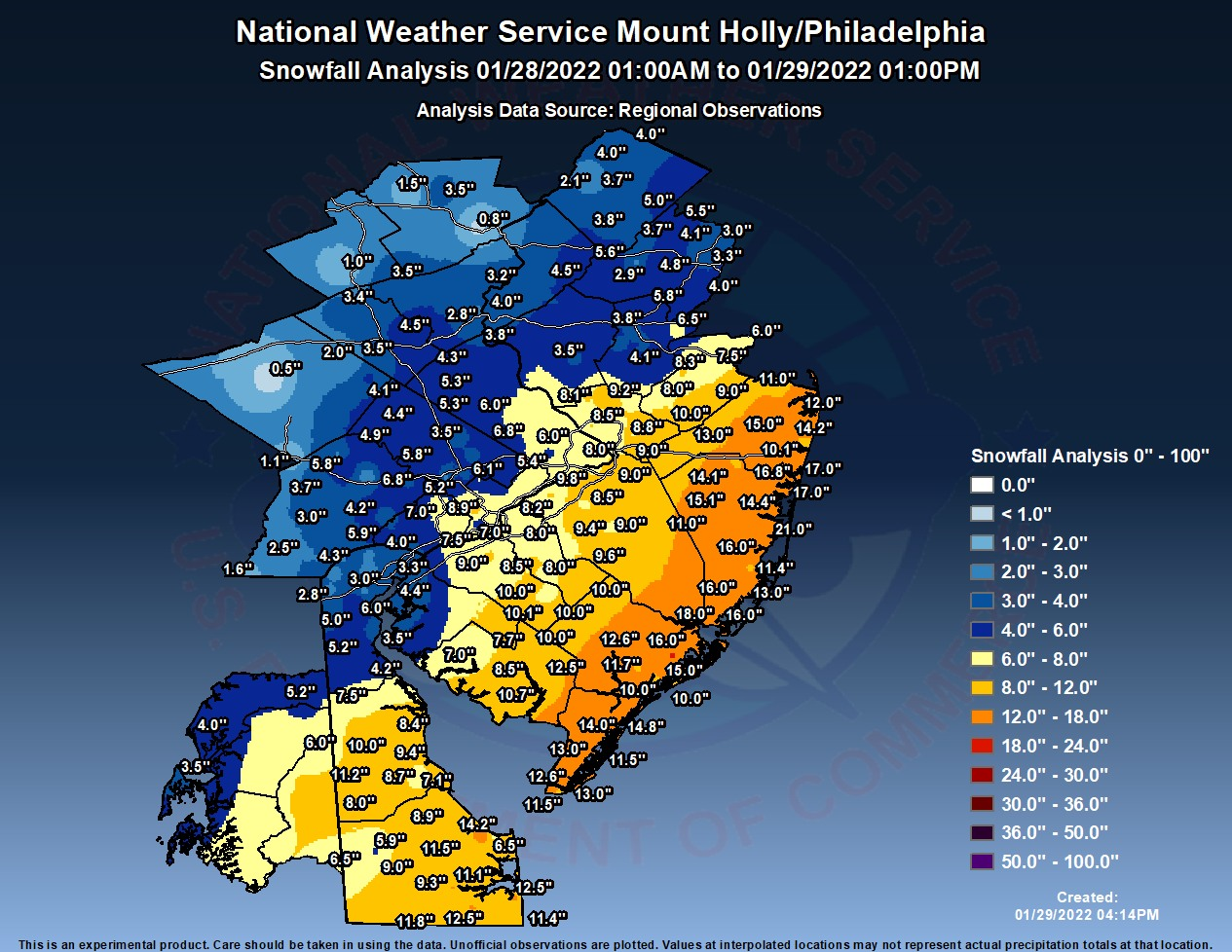
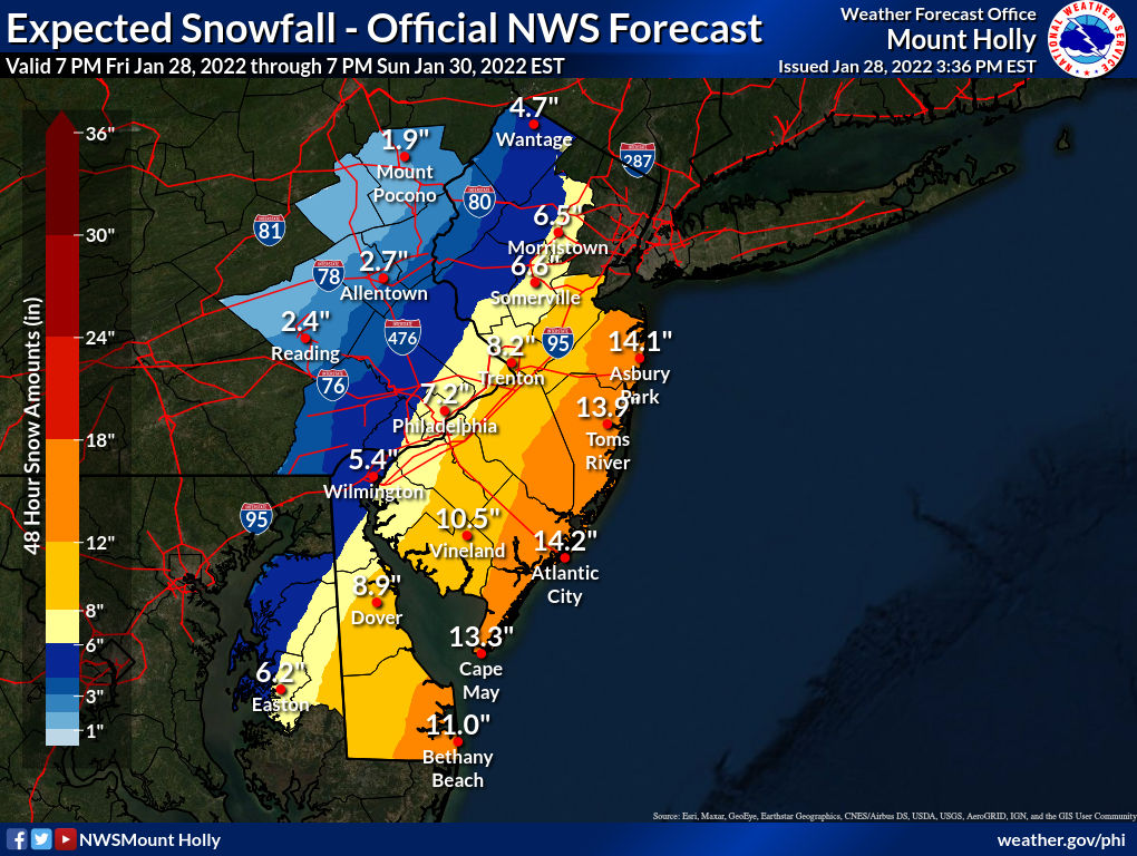
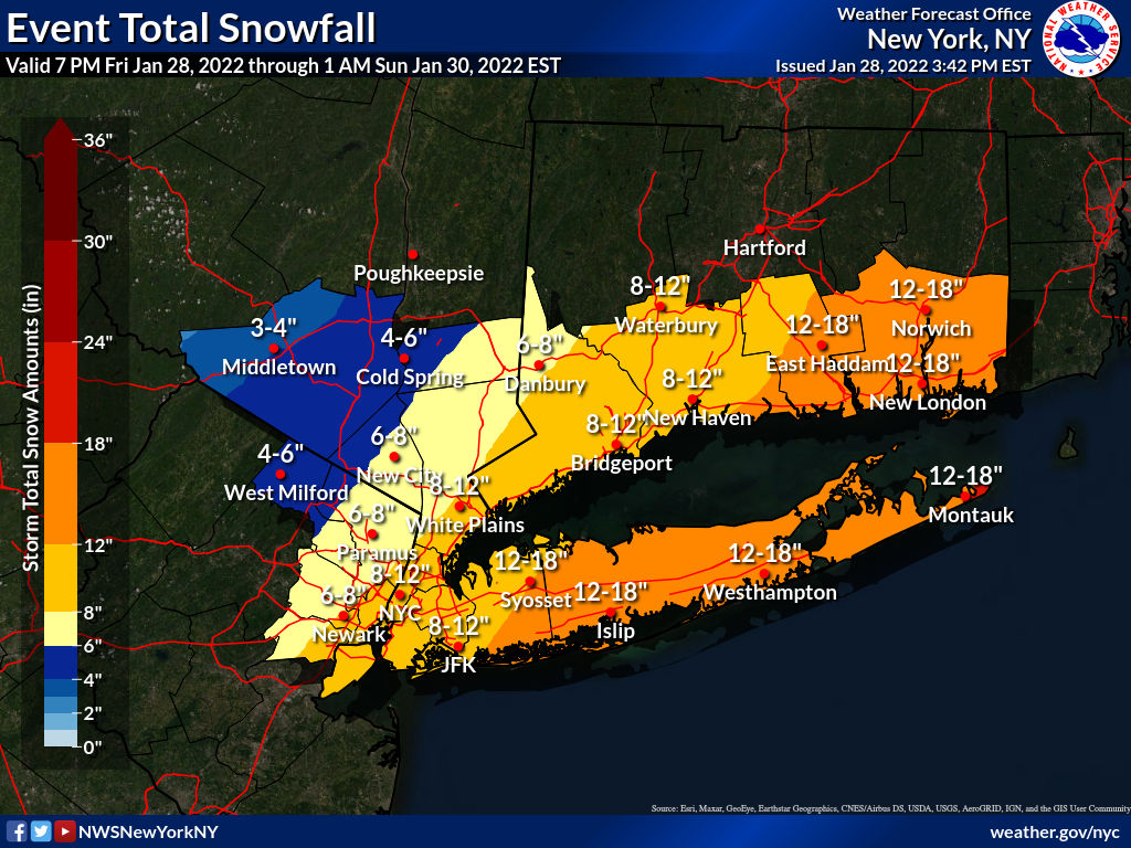
Agreed - for 98% of people in the Philly-NJ-NYC region these threads are for, the NWS forecast (and most others) was superb and where off, it wasn't off by a ton. Just look at the maps of the forecast vs. the actual - the colors line up almost perfectly, plus the forecasts of blizzards for the NJ Coast and LI verified, which is actually pretty amazing, as satisfying blizzard conditions for 3 hours is actually pretty rare. Haven't seen the actual snowfall map for NWS-NYC yet, but that forecast was also superb.
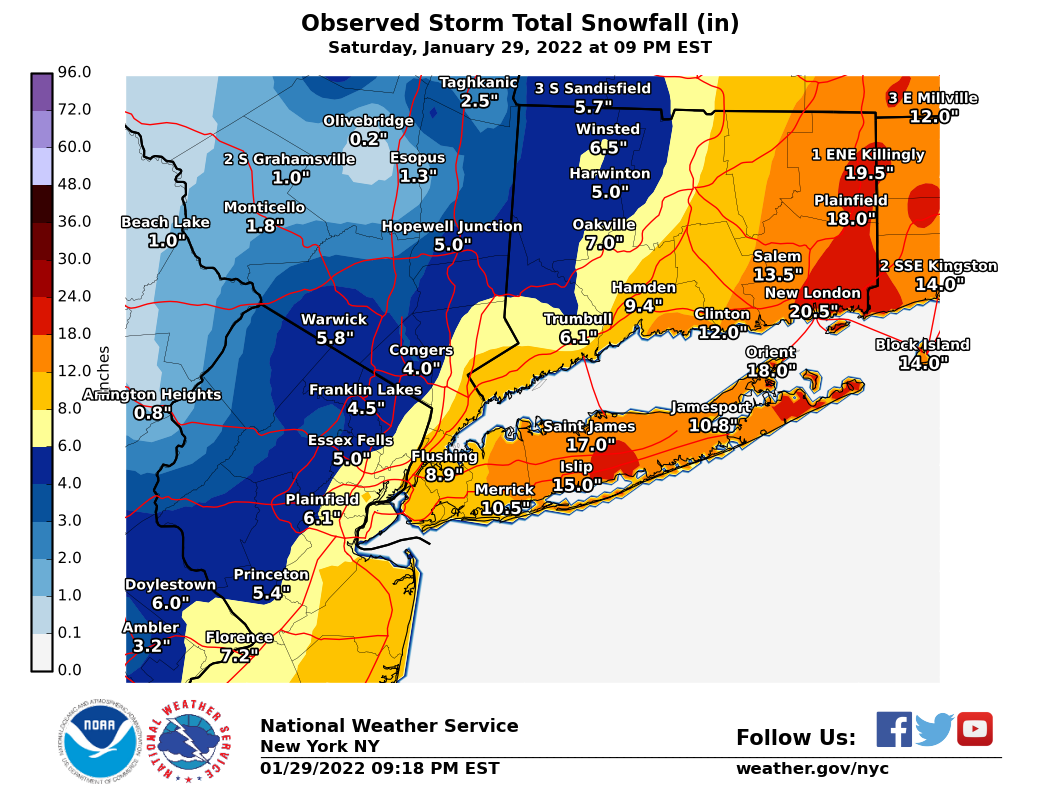
And here are the forecast and actual snowfall maps for the NWS-NYC, again showing this to be a generally superb forecast, where the misses were fairly small.
Paradoxically, the more snow you have left, the more likely most of the rain gets absorbed into the snowpack with less urban flooding, but that just kicks the urban and stream flooding risk can down the road. If there's less snowpack left, the same amount of rain may end up melting much more of it, so the total liquid runoff would increase.But it could be an issue if it doesn’t melt as fast as we want?
I posted 1-3/3-6/6-10 on wed then bumped to 3-6/6-10/10-16 on Thu. Came up shy in my neck of the woods and busted a little low down the beach. Verified in the cities. I'll take it.Yeah, the northern 2/3 of Somerset, eastern Morris and the northern half of Hunterdon all got a bit less than forecast, simply due to less precip, mostly from subsidence, as you said. Did I miss your forecast in the thread? You've been on a really good run and was curious how you did.
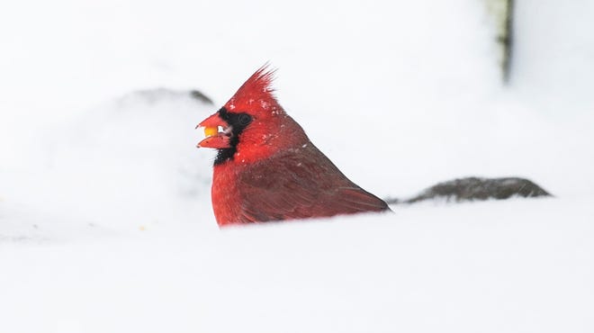
It's a nut or seed from an evergreen tree.Is that a yellow M&M?
Well said...Don't understand the quibbling or sniping about the forecast. As posted by #'s the forecast vs. the actual was very close in almost all areas. Don't recall a forecast panning out so well across the NY/NJ/PA/DE area this well in a long time? Pinpoint forecasts are impossible due to dry slots, blizzard conditions and other local conditions.
I'm used to simplifying (and often muddling) complicated scientific concepts. If only I could do as well in my work every day, I might be an overnight success! 🤣Well said...
Well done - that's a pretty good forecast to me - did you post them in this thread and I missed it? Hard to keep up with all the posts sometimes, lol. I would assume you'd agree that for the vast majority of folks, the NWS forecast was excellent. There are always going to be folks near the edges of forecast swaths who end up in a different swath, but that's not a major bust to me (like the NWS being off a bit in the northern 2/3 of Somerset and most of eastern Morris).I posted 1-3/3-6/6-10 on wed then bumped to 3-6/6-10/10-16 on Thu. Came up shy in my neck of the woods and busted a little low down the beach. Verified in the cities. I'll take it.
Niziol is on Roan Mountain, Tennessee. Given his love of winter weather, he's at ground zero to enjoy and study it, and share his insights. Just above the town of Roan Mountain, Carver's Gap is an AT trailhead that takes you north over the Roan Highlands, a spectacular hike. Hike south, up Roan Mountain itself, and you come upon Roan High Knob Shelter, the highest shelter on the entire AT.Was wondering where Tom went after retirement - on to Twitter fame! He's one of the best winter weather experts out there - I liked him more than Postell who replaced him on TWC, kind of. 8" is still a pretty big event for you guys - skiing must be doing well down there.
Our local ski resorts here are packed, yes. As are local rental homes and other lodging. BUT it's been sub-zero cold per the wind chill up on those mountain-top resorts. Today might reach freezing up top.
Who is this Troy and why’s he such a bad speller?Still haven't put my new TroyBilt to the test this year😤
I posted the first, not sure about the second. I think forecasters across the board did a great job with the forecast and it's messaging.Well done - that's a pretty good forecast to me - did you post them in this thread and I missed it? Hard to keep up with all the posts sometimes, lol. I would assume you'd agree that for the vast majority of folks, the NWS forecast was excellent. There are always going to be folks near the edges of forecast swaths who end up in a different swath, but that's not a major bust to me (like the NWS being off a bit in the northern 2/3 of Somerset and most of eastern Morris).
Looks like my yardFrom Toms River:

we have cardinals all the time
We have what seems like thousands of robins. In the summer, we have cardinals, and have seen eastern goldfinches too.Looks like my yard
we have cardinals all the time
Davin Wydners flight from Florida made it in yesterday !!!

 rutgerswire.usatoday.com

Recruiting insider: Davin Wydner not stopped by blizzard in making Rutgers football visit
Davin Wydner is currently on an official visit with Rutgers football.
Friday is being pushed by the Weather Channel.
Have they named it yet? It's not official until they do!
Landon. Ugh. Hate the names.Have they named it yet? It's not official until they do!
Of course they did. Landon.Have they named it yet? It's not official until they do!
Landon. Ugh. Hate the names.
Michael…
Langan
That's Langdon! 😜

With M up afterL, what trendy name will the next one be?
Maverick
Major
Maddox?
Miles
McKenzie
Mikaela?
So in year's past they had a front loader parked in our tennis court parking lot which would be used for huge dumps of snow. However, starting last year they utilize that plus 2 bobcats. So this is what I saw yesterday to handle 4 inches of snow:
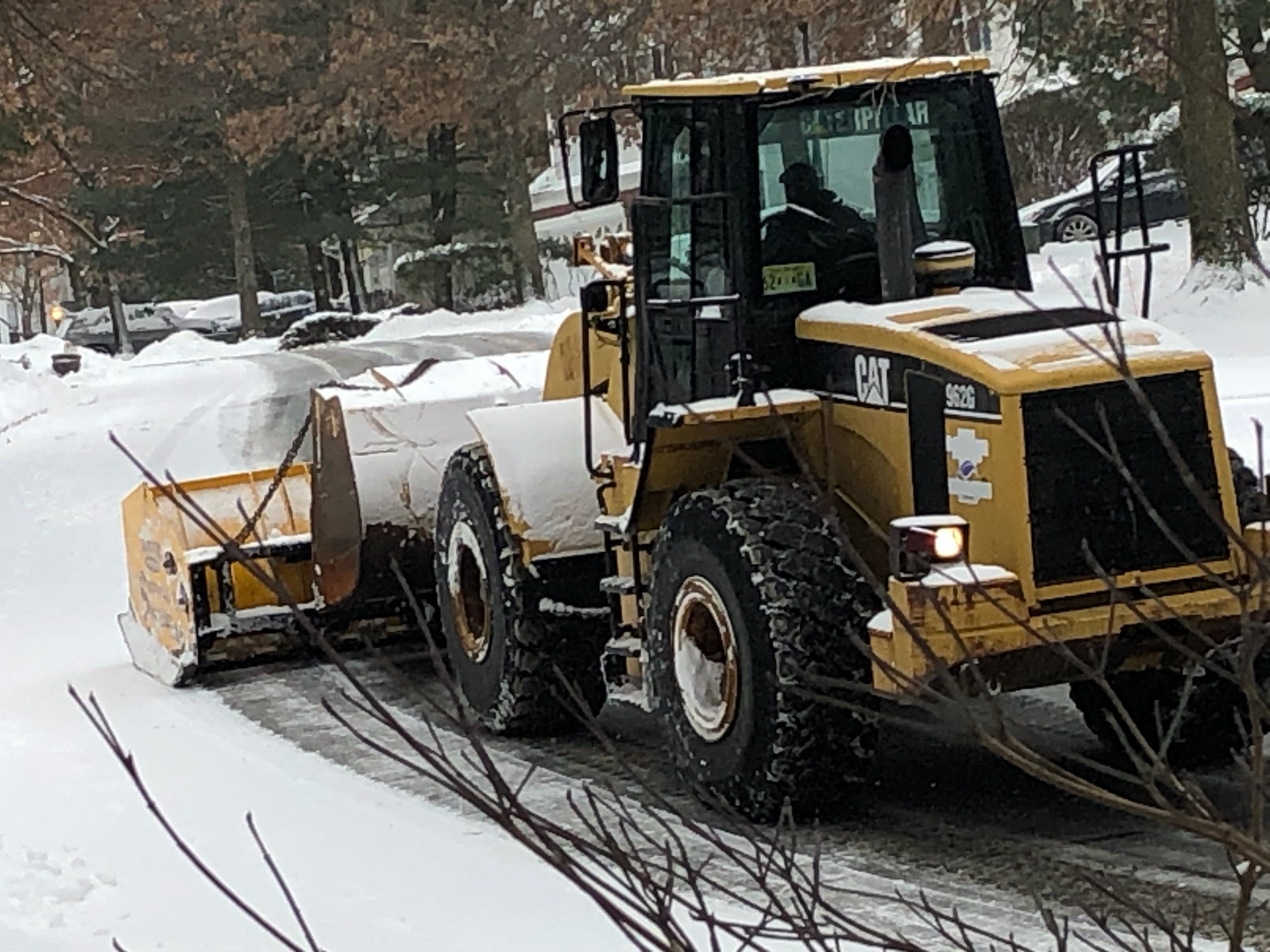
The downside of this is that it is far slower clearing our whole subdivision than a couple of trucks with plows. So we're paying big money for this, and, of course, the landscaper is utilizing his trucks elsewhere to make more money.

The downside of this is that it is far slower clearing our whole subdivision than a couple of trucks with plows. So we're paying big money for this, and, of course, the landscaper is utilizing his trucks elsewhere to make more money.
Friday's system is looking almost all wet by all the models, except that it may end as a period of freezing rain/sleet/snow with some accumuations possible well NW. Definitely not thread worthy yet.Actually the 0Z UK is a raging snowstorm, but it's alone in that, as the GFS/CMC show an all rain event with only some snow well north of I-84, although the Euro shows the cold air coming in fast enough for rain to snow with several inches. I do think a rainy solution is much more likely, but was having a little fun with folks with my teaser of a post, since it's pretty far out in time and nowhere near worth a thread IMO.
Similar threads
- Replies
- 748
- Views
- 38K
- Replies
- 44
- Views
- 3K
- Replies
- 152
- Views
- 8K
ADVERTISEMENT