ADVERTISEMENT

OT: Potential Significant to Major Winter Storm Saturday, 1/29/22 (but high uncertainty)

NWS:


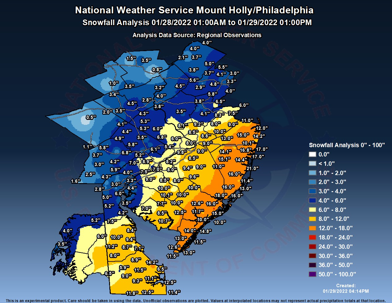
Here's an approximate look at how much snow has fallen so far, with many thanks to the hundreds of reports we've received from all of you! The map is limited by the spatial density of observations and will be refined further to smooth out a few outliers, but it provides a good overview. Also, while the map label displays an end time of 1PM, it is actually closer to 4PM (i.e., most reports before 4PM have been captured). Thanks again for all those reports!


272863885_312104857608952_5434934778052929576_n.jpg
This was my call last night

NW Jersey: 2-5
Hunterdon/Morris: 3-6
Somerset: 5-8
Middlesex/Union up to Newark and Bergen: 6-9
Mercer/Northern Burlington: 6-9
Inland South Jersey: 8-12
Monmouth/Ocean way from coast: 8-12
coastal NJ down to from Monmouth to AC 10-14...edit could see a tongue of 12-16

Philly: 5-8
NYC: 6-9

bravo Bac...I think Bergen is where I screwed up, northern somerset but everything else feel in line. You can see exactly where that tight gradient set up along the borders of southern borders of Hunterdon and Somerset to Mercer and along the western border of Somerset to Middlesex
 
I’m happy with about 7 total in Montclair.
Could have been worse.
I bet my man numbers would love Scotty to beam him to coastal New England for a few hours
LBI would've been good enough, lol. But that seems like cheating, as I want to experience snowstorms at my house. That doesn't rule out a road trip though - been wanting to do a road trip to the snow belt for a big lake effect snowstorm for years. Hoping next winter. Despite not getting a huge snowstorm, half of the fun for me is tracking and posting here and several other places and then sitting back and watching it all unfold from the recliner with my view of the snow falling and going out in it every 30 min or so to measure and take it all in. I even enjoy the shoveling, especially in the middle of the night in the utter silence of my little snow globe.
 
Anyone calling this one a bust should be banned from weather threads.
Agreed - for 98% of people in the Philly-NJ-NYC region these threads are for, the NWS forecast (and most others) was superb and where off, it wasn't off by a ton. Just look at the maps of the forecast vs. the actual - the colors line up almost perfectly, plus the forecasts of blizzards for the NJ Coast and LI verified, which is actually pretty amazing, as satisfying blizzard conditions for 3 hours is actually pretty rare. Haven't seen the actual snowfall map for NWS-NYC yet, but that forecast was also superb.

NpOL7x9.png


sPJpTTt.png
 
Jesus and have you done the same with every other post on this thread?? That is why I'm calling you out because you are wrong again and calling me out when you accept everyone else's measurements. Look at your posts again that I highlighted. Maps were way off. Your posts had maps with 8in. Any 8in in CC Philly? Not only that your posts with 8in + was after the event started and still wrong!
Again for the 1000th time measurements at the Philly Airport is in Delaware County.
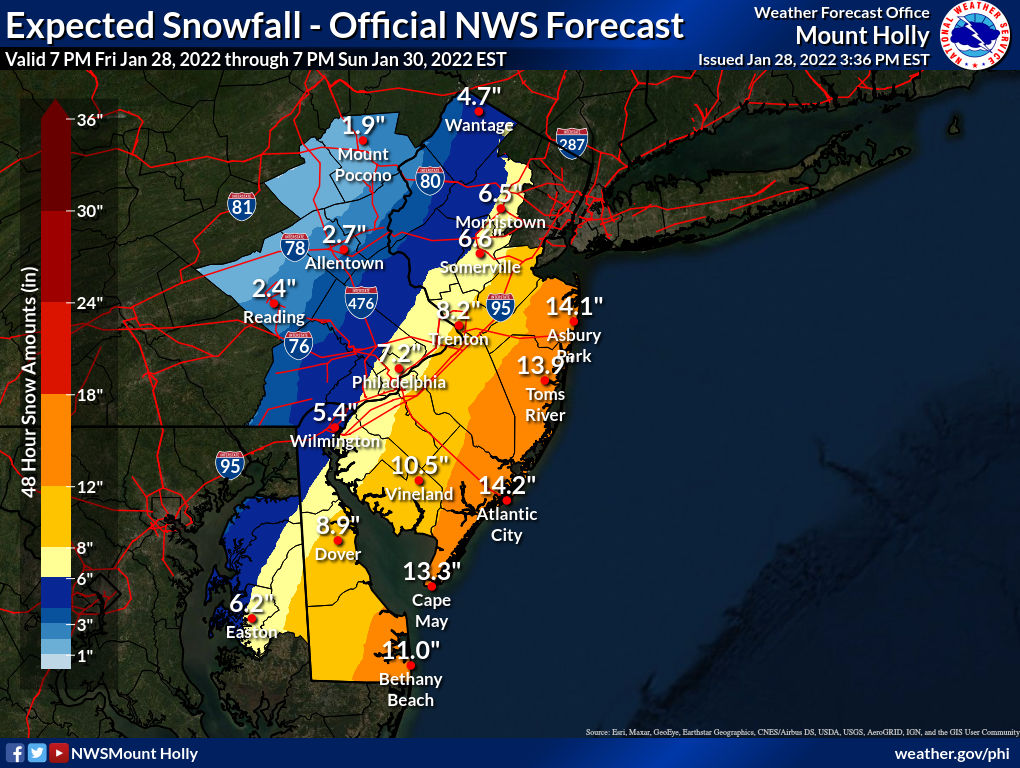
No, but you always whine bust and you're usually wrong, as you are again this time, so I usually try to correct such posts, especially when a forecast was so good (already did with T, so you're not alone). With regard to maps, the main one I posted a few times is the NWS one, below, which unequivocally shows Philly in the 6-8" yellow swath, as well as the NWS's best guess for 7.2" of snow in Philly, which is actually for 7.2" at Philadelphia Int'l Airport, the station of record for Philly. And the map of actual snowfall has, lo and behold, all of Philadelphia County in the 6-8" yellow swath - if that's not a bang on forecast, I don't know what is.

And with regard to what actually fell, those preliminary reports are just that - preliminary. Pretty much any reports before when the precip was over are generally dropped from the final reports and in this case, here are the only reports in the current (final, I believe) PNS. Yes, all three are between 6 and 8 inches and my guess is the other ones were eliminated because they were incomplete (from before the snow stopped - many early reports get eliminated in later reports - see the link) and they didn't update the NWS with final snowfalls. As an aside, if you measured the snowfall to be less than 6" in South Philly, maybe you should start posting accumulation reports (and I never said a word about South Philly - you brought it up later).

...Philadelphia County...
1 W Belmont 8.9 in 1230 PM 01/29 Trained Spotter
Philadelphia International A 7.5 in 0100 PM 01/29 ASOS
Chestnut Hill 6.1 in 0207 PM 01/29 Public

https://www.wrh.noaa.gov/total_forecast/getprod.php?afos=xxxpnsphi&wfo=phi&font=120&new=1&version=3

I also have zero idea why you're rambling about other maps and 8"+ as I never showed maps saying Philly was getting more than 8". The other forecast maps I showed from Lee Goldberg and Steve DiMartino were just additional forecasts, but the NWS is the main one I usually go by, but having said that, both of those other maps had Philly in a 6-12" swath, which is a bit wide, but that's what they showed (and those did verify). I have zero idea why you made some other post showing the Euro model output as that's irrelevant - it's not a forecast, it's just a model run.

And finally, we get to one thing you said that was right, but irrelevant. Yes, part of the airport is in Delaware County, but most of it is in Philadelphia County, as per this, from the wiki page: "Most of the airport property is in Philadelphia proper. The international terminal and the western end of the airfield are in Tinicum Township, Delaware County." And it does turn out that the weather station is in the Delaware County part, literally yards from Philadelphia. However, that's irrelevant, as per the words from NWS met, Mike Gorse, who I asked about this on line and who said, "It is technically in Delaware County. We list it as in Philadelphia County though for continuity plus it represents Philadelphia." Case closed.
https://en.wikipedia.org/wiki/Phila...property,in Tinicum Township, Delaware County.

sPJpTTt.png


NpOL7x9.png
 
No, but you always whine bust and you're usually wrong, as you are again this time, so I usually try to correct such posts, especially when a forecast was so good (already did with T, so you're not alone). With regard to maps, the main one I posted a few times is the NWS one, below, which unequivocally shows Philly in the 6-8" yellow swath, as well as the NWS's best guess for 7.2" of snow in Philly, which is actually for 7.2" at Philadelphia Int'l Airport, the station of record for Philly. And the map of actual snowfall has, lo and behold, all of Philadelphia County in the 6-8" yellow swath - if that's not a bang on forecast, I don't know what is.

And with regard to what actually fell, those preliminary reports are just that - preliminary. Pretty much any reports before when the precip was over are generally dropped from the final reports and in this case, here are the only reports in the current (final, I believe) PNS. Yes, all three are between 6 and 8 inches and my guess is the other ones were eliminated because they were incomplete (from before the snow stopped - many early reports get eliminated in later reports - see the link) and they didn't update the NWS with final snowfalls. As an aside, if you measured the snowfall to be less than 6" in South Philly, maybe you should start posting accumulation reports (and I never said a word about South Philly - you brought it up later).

...Philadelphia County...
1 W Belmont 8.9 in 1230 PM 01/29 Trained Spotter
Philadelphia International A 7.5 in 0100 PM 01/29 ASOS
Chestnut Hill 6.1 in 0207 PM 01/29 Public

https://www.wrh.noaa.gov/total_forecast/getprod.php?afos=xxxpnsphi&wfo=phi&font=120&new=1&version=3

I also have zero idea why you're rambling about other maps and 8"+ as I never showed maps saying Philly was getting more than 8". The other forecast maps I showed from Lee Goldberg and Steve DiMartino were just additional forecasts, but the NWS is the main one I usually go by, but having said that, both of those other maps had Philly in a 6-12" swath, which is a bit wide, but that's what they showed (and those did verify). I have zero idea why you made some other post showing the Euro model output as that's irrelevant - it's not a forecast, it's just a model run.

And finally, we get to one thing you said that was right, but irrelevant. Yes, part of the airport is in Delaware County, but most of it is in Philadelphia County, as per this, from the wiki page: "Most of the airport property is in Philadelphia proper. The international terminal and the western end of the airfield are in Tinicum Township, Delaware County." And it does turn out that the weather station is in the Delaware County part, literally yards from Philadelphia. However, that's irrelevant, as per the words from NWS met, Mike Gorse, who I asked about this on line and who said, "It is technically in Delaware County. We list it as in Philadelphia County though for continuity plus it represents Philadelphia." Case closed.
https://en.wikipedia.org/wiki/Philadelphia_International_Airport#:~:text=Most of the airport property,in Tinicum Township, Delaware County.

sPJpTTt.png


NpOL7x9.png
Love how you cherry pick. I'm not stupid. I reposted them yesterday. You arguing about Philly totals is as stupid as me trying arguing where you live. It was a bust where I live. Go argue with someone else. I've had enough of your crap.
 
  • Like
Reactions: goru1869
LBI would've been good enough, lol. But that seems like cheating, as I want to experience snowstorms at my house. That doesn't rule out a road trip though - been wanting to do a road trip to the snow belt for a big lake effect snowstorm for years. Hoping next winter. Despite not getting a huge snowstorm, half of the fun for me is tracking and posting here and several other places and then sitting back and watching it all unfold from the recliner with my view of the snow falling and going out in it every 30 min or so to measure and take it all in. I even enjoy the shoveling, especially in the middle of the night in the utter silence of my little snow globe.
I know what you mean about the shoveling at night. It can be quite peaceful
 
  • Like
Reactions: RU848789
I'm sure records for OC are sketchy at best, but AC's biggest January snowfall ever is 20.3", which means they couldn't have ever had a January with 2 one-foot storms - don't know about Feb, but unlikely. AC is also ahead of Burlington - VT, not NJ - in seasonal snowfall to date. Crazy.

https://www.accuweather.com/en/weat...zzard-warning-as-snowstorm-approaches/1132971
Atlantic City International Airport, with this storm, set a record for the most January snowfall since at least 1945. As of 1 p.m. Saturday, 33.2 inches of snow had fallen month to date, smashing the old January record of 20.3 inches in 1987.
 
Love how you cherry pick. I'm not stupid. I reposted them yesterday. You arguing about Philly totals is as stupid as me trying arguing where you live. It was a bust where I live. Go argue with someone else. I've had enough of your crap.
I thought Philly set a 1 day record for snowfall on for this date. Can you define bust? Forecast was off by an inch or two where you live, but the Northeast in general got pummeled.

Bust is a whiff when the storm fails to materialize….this storm hit, maybe not prrfectly everywhere….seems to be nit picky if you ask me
 
  • Like
Reactions: TRU2RU and RU848789
Just went outside to check, likely 4-5 inches at most. However, probably only half that to shovel due to the wind. Enough for the kids to play in and sled, so mission accomplished.

Definitely another forecast bust. Will they ever learn?
Montclair/Clifton seemed to get about 5-6 inches, which was in the 4-8 range of the forecast and down by Tom’s river about a foot which again was pretty accurate
 
Last edited:
  • Like
Reactions: RU848789
I will keep this simple. The storm was not a bust near the coast in Belmar. I will add that it is -2 with the wind factored in this morning.
Agreed. On LBI we got over a foot. Due to high winds there is an inch near the front of the house and 3-4 foot drifts on the lane. Wind chill this am was -4
 
  • Like
Reactions: Knight Shift
What’s this Friday shit all about numbers. I cancelled all my Friday night/Saturday plans this past week until this coming Friday night/Saturday. We got another one incoming?
 
Don't understand the quibbling or sniping about the forecast. As posted by #'s the forecast vs. the actual was very close in almost all areas. Don't recall a forecast panning out so well across the NY/NJ/PA/DE area this well in a long time? Pinpoint forecasts are impossible due to dry slots, blizzard conditions and other local conditions.


Friday is a rain event for everyone for now. There's are evolutions that could bring frozen precip into the picture but none of the models are suggesting that right now.
 
I thought Philly set a 1 day record for snowfall on for this date. Can you define bust? Forecast was off by an inch or two where you live, but the Northeast in general got pummeled.

Bust is a whiff when the storm fails to materialize….this storm hit, maybe not prrfectly everywhere….seems to be nit picky if you ask me
Maps provided on this thread had Philadelphia getting between 6 to 12 inches. TV stations in Philadelphia had the eastern part of the city including Center City in the 7-9 range. We got 4. Measurements from the airport, which are not even in Philadelphia is 10 miles Southwest of City Hall. A comparison even Numbers should understand is that is the distance from Metuchen to Staten Island.
One of the other measurements included in the list was Belmont. An area of Fairmount Park. Fairmount Park is 5x bigger then Central Park and 3x bigger then Metuchen. Both the airport and the park had measurable snow Friday. The city did not. I would call the difference between 4in and 7-9 a bust. At the same time I gave credit for the forecast along the coast as they nailed it.
 
Last edited:
Montclair/Clifton seemed to get about 5-6 inches, which was in the 4-8 range of the forecast and down by Tom’s river about a foot which again was pretty accurate
Around 16"-20" along the Ocean and Monmouth coasts so no "Bust" here.

"But the snow increased as you headed south and along the coast: Eatontown got 14 inches. Howell got 15 inches. Spring Lake Heights got 17 inches."

"Toms River and Ocean County got even more snow: Forked River had 17 inches. Beachwood logged 19 inches and Bayville had 21 inches."

 
  • Like
Reactions: RU848789
I got skunked in subsidence west of the good stuff. Readington, a touch under 4".
Still haven't put my new TroyBilt to the test this year😤
 
  • Like
Reactions: RU848789
One of the better weather threads, as I said earlier. Y'all ready for Friday?
Yeah, in the new thread.😎
Friday is being pushed by the Weather Channel.

Despite the risk of starting a skirmish, can you elaborate some re: "Friday"?

For the Manasquan area, this is what the NWS forecast says:

"
Friday
A chance of showers. Mostly cloudy, with a high near 48. Chance of precipitation is 50%."

What’s this Friday shit all about numbers. I cancelled all my Friday night/Saturday plans this past week until this coming Friday night/Saturday. We got another one incoming?
All of this will be discussed, including the below…
Friday is a rain event for everyone for now. There's are evolutions that could bring frozen precip into the picture but none of the models are suggesting that right now.
In the new thread.😊
 
Last edited:
On measurement, quibbling and bickering over totals:
Snowfall measurement is more complicated that one might think. The government has a 14-page manual with all the dirty details. It’s not beach reading. (Not that anything would have been Saturday at the Shore.)

 
  • Like
Reactions: RU848789
Friday is a rain event for everyone for now. There's are evolutions that could bring frozen precip into the picture but none of the models are suggesting that right now.
Actually the 0Z UK is a raging snowstorm, but it's alone in that, as the GFS/CMC show an all rain event with only some snow well north of I-84, although the Euro shows the cold air coming in fast enough for rain to snow with several inches. I do think a rainy solution is much more likely, but was having a little fun with folks with my teaser of a post, since it's pretty far out in time and nowhere near worth a thread IMO.
 
I got skunked in subsidence west of the good stuff. Readington, a touch under 4".
Still haven't put my new TroyBilt to the test this year😤
Yeah, the northern 2/3 of Somerset, eastern Morris and the northern half of Hunterdon all got a bit less than forecast, simply due to less precip, mostly from subsidence, as you said. Did I miss your forecast in the thread? You've been on a really good run and was curious how you did.
 
Actually the 0Z UK is a raging snowstorm, but it's alone in that, as the GFS/CMC show an all rain event with only some snow well north of I-84, although the Euro shows the cold air coming in fast enough for rain to snow with several inches. I do think a rainy solution is much more likely, but was having a little fun with folks with my teaser of a post, since it's pretty far out in time and nowhere near worth a thread IMO.
Are you kidding me? LOL

Now I don’t even know if it’s thread worthy to begin with.

But in all seriousness, if it rains as bad as some predict, that can’t be good.
 
LOL... #s kicks the hornet's nest then hits the exit? C'mon @RU848789. What's your read on "Friday" at this early point?
Just posted on it - not above having a little fun - it is just the weather, after all, lol - how much did you get from the storm? Saw there were some 6" amounts in the NC mountains from the southern low before the coastal formed on Friday, presumably.
 
  • Like
Reactions: RUinPinehurst
Just posted on it - not above having a little fun - it is just the weather, after all, lol - how much did you get from the storm? Saw there were some 6" amounts in the NC mountains from the southern low before the coastal formed on Friday, presumably.
So much wind up here, it was hard to assess. I rode the ATV around the mountain top and saw exposed road surface at points and 24" drifts at others. In sheltered spots, depth looked to be 8" or so.

More from TN:
 
  • Like
Reactions: RU848789
ADVERTISEMENT
ADVERTISEMENT