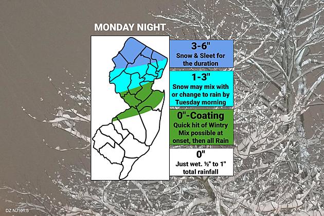
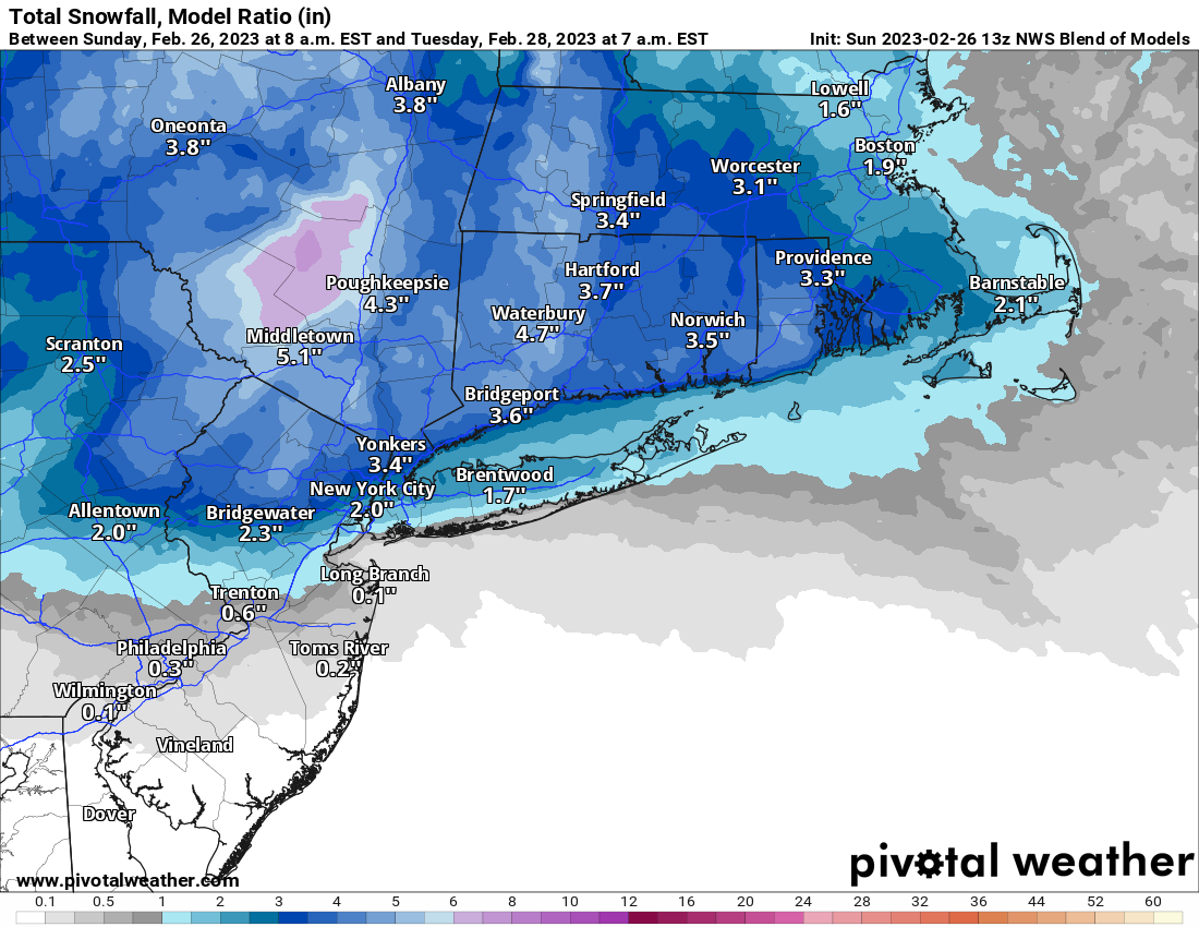
Been a bit busy with life (Melody Reunion was last night and recovery today was longer, given age, lol, plus I had to do a bunch of errands/chores), so just getting to this. Interestingly, the NWS did increase snowfall amounts a bit, as per the maps below from this morning, but not nearly as much as most models are showing (as per the model blend map below). This was especially true for the NYC office, as there is now a significant discontinuity between the NYC/Philly offices, with NYC being more bullish, especially near/along 78. NWS-NYC has 2-3" along 78 from Newark to NE Somerset County, while NWS-Philly has only 1" along 78 from NE Somerset County out to Clinton with <1" south of there. I'm also surprised they didn't explain the reasoning behind discounting most of the models showing at least a couple of inches in much of CNJ south of 78 and for all of NYC.
Given that the 12Z models which came out noon-ish today mostly held serve showing even an inch or so down to 276/195 and a few inches from there up to 78 (i.e., most of CNJ) and several inches along/N of 78 and 5-7" along/N of 80 (except for the NAM, which showed little snow S of 78), it will be interesting to see if the NWS adjusts snowfall upwards with this afternoon's packages - I think they will. Having said that, areas S of 78 are the most likely to see some or mostly rain (and maybe all rain close to 276/195 and south of there), which would wash away anything less than 1-2" of snow (about 0.5-0.75" of total liqud equivalent precip is forecast).
In addition, there is also some signal that there could be a warm layer aloft, melting the snow a few thousand feet up, but having it freeze into sleet falling through the colder layer towards the surface - this is most likely to occur south of 80 (north of there is more likely to stay below 32F throughout the entire atmospheric column). Sleet is just as impactful as snow for the same frozen mass (except for visibility issues) - it just is only about 1/3 as deep on the ground (and melts slower, due to the much lower surface area exposed per unit volume for each crystal). Still ~36 hours from when the models initiated (7 am EST) to when the event will start tomorrow late afternoon/early evening.
https://www.weather.gov/phi/