
Could have told you that 2 days ago!Done here. Barely stuck to anything. Is this a dusting or just nuisance snow?
Massive bust!
Colleges
- American Athletic
- Atlantic Coast
- Big 12
- Big East
- Big Ten
- Colonial
- Conference USA
- Independents (FBS)
- Junior College
- Mountain West
- Northeast
- Pac-12
- Patriot League
- Pioneer League
- Southeastern
- Sun Belt
- Army
- Charlotte
- East Carolina
- Florida Atlantic
- Memphis
- Navy
- North Texas
- Rice
- South Florida
- Temple
- Tulane
- Tulsa
- UAB
- UTSA
- Boston College
- California
- Clemson
- Duke
- Florida State
- Georgia Tech
- Louisville
- Miami (FL)
- North Carolina
- North Carolina State
- Pittsburgh
- Southern Methodist
- Stanford
- Syracuse
- Virginia
- Virginia Tech
- Wake Forest
- Arizona
- Arizona State
- Baylor
- Brigham Young
- Cincinnati
- Colorado
- Houston
- Iowa State
- Kansas
- Kansas State
- Oklahoma State
- TCU
- Texas Tech
- UCF
- Utah
- West Virginia
- Illinois
- Indiana
- Iowa
- Maryland
- Michigan
- Michigan State
- Minnesota
- Nebraska
- Northwestern
- Ohio State
- Oregon
- Penn State
- Purdue
- Rutgers
- UCLA
- USC
- Washington
- Wisconsin
High Schools
- Illinois HS Sports
- Indiana HS Sports
- Iowa HS Sports
- Kansas HS Sports
- Michigan HS Sports
- Minnesota HS Sports
- Missouri HS Sports
- Nebraska HS Sports
- Oklahoma HS Sports
- Texas HS Hoops
- Texas HS Sports
- Wisconsin HS Sports
- Cincinnati HS Sports
- Delaware
- Maryland HS Sports
- New Jersey HS Hoops
- New Jersey HS Sports
- NYC HS Hoops
- Ohio HS Sports
- Pennsylvania HS Sports
- Virginia HS Sports
- West Virginia HS Sports
ADVERTISEMENT
You are using an out of date browser. It may not display this or other websites correctly.
You should upgrade or use an alternative browser.
You should upgrade or use an alternative browser.
OT: Significant Winter Storm 2/27-28 (esp along/N of 78); and update on Fri storm (p. 6)
- Thread starter RU848789
- Start date

5 pages for a nothing storm. Didn't the OP promise to leave and not do any more weather posts this year? LOL!Could have told you that 2 days ago!
BOOM! Officially calling it:Yup its all rain now
All hail King Nam!

It was advertised as a significant storm along/N of 78 (3" or more, which should verify) and the troll brothers are way south of 78 (~15 miles) and predicted to be on the border between the 1-2" to 2-3" swaths and reports were of about 1.5" from where they are, which is a minor bust, at most. Almost hit 2" here and Metuchen was in the 1-2" swath, close to the 2-3" swath, so that's a pretty good forecast. My guess is most locations won't be too far off what the NWS forecasted.Not a bust for a good portion of us. Lots of delayed openings and school closures already.
Certainly not a big storm but being the first of the season.it was an event for sure
We've had a minor snow miracle, as it just flipped back to a snow/sleet mixture 10 minutes ago and we now have 0.3" of sleet/snow mix since the lull (luckily sleet doesn't melt or compact nearly as quickly as snow, so the 0.2" of sleet we had didn't budge over the last hour of mostly rain with some sleet), bringing our total snow/sleet accumulation to 2.0". Not sure how much longer this will last, but it was a nice surprise.We've had a decent rate of mostly sleet falling since about 10:45 pm, with about 0.2" sleet accumulation, bringing our total snow/sleet accumulation to 1.9" (yes, sleet counts). Looks like the snow might be over as it's raining south of the Driscoll Bridge just about 5 miles SE from here, although if we get more intensity, it could flip back to snow as snow is only about 5 miles N of me, lol. It's 34F.
You may still flip back to snow/sleet, looking at the radar, although you may only have another 15-20 min of precip left in this batch and the precip looks much more scattered after that. NWS predicted 3-4" for your location, so that's a good forecast.A solid 3” accumulation in Warren atop the second Watchung ridge. Switched to freezing rain now.
Almost time for a thread on the Friday night event - could end up somewhat similar to this one with several inches along/N of 78 and more along/N of 80, with minor accumulations (and a fair amount of rain) for areas S of 78 and along/SE of 95. 4 days away, so let's see what tomorrow's models say...
Done here. Barely stuck to anything. Is this a dusting or just nuisance snow?
Massive bust!
How can a storm that was forecasted to me minor ever be a massive bust?
Seems like an oxymoron
Yet youre in this thread participating all nightNot even a nuisance event imby
Weird
The oxymoron was calling this a "significant" storm.How can a storm that was forecasted to me minor ever be a massive bust?
Seems like an oxymoron
Hawthorne NJ checking in at 5 inches. New puppy loving it
If this thread is not for you, please do us all a favor and just stay away then instead of being a constant d*ckhead.5 pages for a nothing storm. Didn't the OP promise to leave and not do any more weather posts this year? LOL!
Was just gonna apply the same fix.FIFY
5.75" here in Towaco and our forecast was for 5-8. We had no mixing at all. It is still flurrying here now.
People here in Sedona are in disbelief that until yesterday, no snow in NJ. Checked our cameras at home in Monmouth county, and all rain.Was just gonna apply the same fix.
5.75" here in Towaco and our forecast was for 5-8. We had no mixing at all. It is still flurrying here now.
Woke up here to major winter storm warning for tomorrow night in Sedona. Another 8 plus inches predicted.
Do you foresee that impacting flights into Newark? 10 pm landing Friday.Almost time for a thread on the Friday night event - could end up somewhat similar to this one with several inches along/N of 78 and more along/N of 80, with minor accumulations (and a fair amount of rain) for areas S of 78 and along/SE of 95. 4 days away, so let's see what tomorrow's models say...
NWS has it too warm along the coast. Hope it stays that way.Almost time for a thread on the Friday night event - could end up somewhat similar to this one with several inches along/N of 78 and more along/N of 80, with minor accumulations (and a fair amount of rain) for areas S of 78 and along/SE of 95. 4 days away, so let's see what tomorrow's models say...
I will tell you the sea is angry my friend, like an old man trying to return soup at a deli.Do you foresee that impacting flights into Newark? 10 pm landing Friday.
Was the total precipitation in Sedona much higher than normal this winter?People here in Sedona are in disbelief that until yesterday, no snow in NJ. Checked our cameras at home in Monmouth county, and all rain.
Woke up here to major winter storm warning for tomorrow night in Sedona. Another 8 plus inches predicted.
They were fine for my commute from NP to New Brunswick. They looked good on the news in other parts of the state.How are the roads? From traffic cameras they don't look bad. Looks like fair number of schools pulled the trigger very early last night when they may have been able to get away with a delayed opening.
Dan Zarrow 101.5
Bergen County
Forecast: 3-6+" West, 1-3" East6.0" Oakland
5.0" Montvale
4.8" Fair Lawn
3.8" Bergenfield
3.6" Tenafly
Essex County
Forecast: 1-3"4.8" Verona
4.1" Cedar Grove
4.0" West Orange
2.5" Maplewood
1.7" Newark Airport
Hudson County
Forecast: 1-3"
2.5" Harrison
Hunterdon County
Forecast: 1-3"3.5" Clinton
3.0" Lebanon
2.8" High Bridge
2.5" Readington
2.5" Holland
1.2" Flemington (at 9:20 p.m.)
Mercer County
Forecast: 0-1"1.0" Trenton Mercer Airport (at 9 p.m.)
1.0" West Windsor
0.6" Hamilton Square (at 9:45 p.m.)
Middlesex County
Forecast: 1-3" North, 0-1" Central/South2.1" Hopelawn
1.9" Metuchen
1.7" Woodbridge
1.4" North Brunswick
1.0" Old Bridge
0.8" South River
Monmouth County
Forecast: 0-1" Inland, 0" CoastMorris County
Forecast: 3-6+" North, 1-3" South6.0" Kinnelon
5.8" Brookside
5.8" Mine Hill
5.3" Randolph
5.3" Rockaway
5.3" Denville
5.2" Randolph
4.0" Morristown
4.0" Mendham
Passaic County
Forecast: 3-6+" North, 1-3" South6.0" Bloomingdale
5.5" Wayne
4.8" Little Falls
4.6" Hawthorne
4.4" Pompton Lakes
Somerset County
Forecast: 1-3"3.5" Watchung
3.0" Franklin
3.0" Warren
2.9" Bernards
2.7" Green Brook
2.0" Neshanic Station (at 11:20 p.m.)
1.5" Bridgewater (at 11 p.m.)
Sussex County
Forecast: 3-6+"6.9" Vernon
6.4" Montague
6.2" Wantage
5.5" Hardyston
4.4" Franklin
4.3" Sparta
4.0" Andover
Union County
Forecast: 1-3"3.0" Clark
1.5" New Providence
1.0" Cranford
1.0" Westfield
Warren County
Forecast: 3-6+" North, 1-3" South4.3" Blairstown
4.1" Frelinghuysen
4.0" Hackettstown
3.7" Mansfield
2.3" Stewartsville
2.2" Harmony
5"? Wow, Fair Lawn -- if we got 2" that's a lot.Hawthorne NJ checking in at 5 inches. New puppy loving it
That's hard to pin down. Can't find an accurate website with data. It has not snowed much in the last 5-10 years, so this winter feels higher than normal. But found this:Was the total precipitation in Sedona much higher than normal this winter?
How many days does it snow in Sedona?
Throughout the year, in Sedona, Arizona, there are 10.6 snowfall days, and 8.9" (226mm) of snow is accumulated.
Yearly & Monthly weather - Sedona, AZ
Sedona, Arizona, USA - Climate and weather forecast by month. Detailed climate information with charts - average monthly weather with temperature, pressure, humidity, precipitation, wind, daylight, sunshine, visibility, and UV index data. December is the month when Sedona sees the average lowest...

Weather averages Sedona, Arizona
Climate Data Sedona. Monthly temperature, precipitation and climate graph.
 www.usclimatedata.com
Could have told you that 2 days ago!
5 pages for a nothing storm. Didn't the OP promise to leave and not do any more weather posts this year? LOL!
BOOM! Officially calling it:

Too bad you won't promise to stop trolling #s threads. Don't you have something better to do in your life.5 pages for a nothing storm. Didn't the OP promise to leave and not do any more weather posts this year? LOL!
It appears the NWS was close to spot on.
Whale soup? 😀I will tell you the sea is angry my friend, like an old man trying to return soup at a deli.
Seems like the forecast was spot on.Dan Zarrow 101.5
Bergen County
Forecast: 3-6+" West, 1-3" East
6.0" Oakland
5.0" Montvale
4.8" Fair Lawn
3.8" Bergenfield
3.6" Tenafly
Essex County
Forecast: 1-3"
4.8" Verona
4.1" Cedar Grove
4.0" West Orange
2.5" Maplewood
1.7" Newark Airport
Hudson County
Forecast: 1-3"
2.5" Harrison
Hunterdon County
Forecast: 1-3"
3.5" Clinton
3.0" Lebanon
2.8" High Bridge
2.5" Readington
2.5" Holland
1.2" Flemington (at 9:20 p.m.)
Mercer County
Forecast: 0-1"
1.0" Trenton Mercer Airport (at 9 p.m.)
1.0" West Windsor
0.6" Hamilton Square (at 9:45 p.m.)
Middlesex County
Forecast: 1-3" North, 0-1" Central/South
2.1" Hopelawn
1.9" Metuchen
1.7" Woodbridge
1.4" North Brunswick
1.0" Old Bridge
0.8" South River
Monmouth County
Forecast: 0-1" Inland, 0" Coast
Morris County
Forecast: 3-6+" North, 1-3" South
6.0" Kinnelon
5.8" Brookside
5.8" Mine Hill
5.3" Randolph
5.3" Rockaway
5.3" Denville
5.2" Randolph
4.0" Morristown
4.0" Mendham
Passaic County
Forecast: 3-6+" North, 1-3" South
6.0" Bloomingdale
5.5" Wayne
4.8" Little Falls
4.6" Hawthorne
4.4" Pompton Lakes
Somerset County
Forecast: 1-3"
3.5" Watchung
3.0" Franklin
3.0" Warren
2.9" Bernards
2.7" Green Brook
2.0" Neshanic Station (at 11:20 p.m.)
1.5" Bridgewater (at 11 p.m.)
Sussex County
Forecast: 3-6+"
6.9" Vernon
6.4" Montague
6.2" Wantage
5.5" Hardyston
4.4" Franklin
4.3" Sparta
4.0" Andover
Union County
Forecast: 1-3"
3.0" Clark
1.5" New Providence
1.0" Cranford
1.0" Westfield
Warren County
Forecast: 3-6+" North, 1-3" South
4.3" Blairstown
4.1" Frelinghuysen
4.0" Hackettstown
3.7" Mansfield
2.3" Stewartsville
2.2" Harmony
Thanks #s
Geeze, I thought you'd be fantasizing about them as sheep.
We are up in the highest part of Hawthorne near North Haledon. We usually get more then the center of town by an inch or 2 just due to elevation5"? Wow, Fair Lawn -- if we got 2" that's a lot.
It's true that, In addition to pointing out the undeniably truth that they are a wanna-be mean girls clique, I do sometimes also see them as a flock of easily shepherded sheep.Geeze, I thought you'd be fantasizing about them as sheep.
But that was more of a CE board thing.
Dan Zarrow 101.5
Bergen County
Forecast: 3-6+" West, 1-3" East
6.0" Oakland
5.0" Montvale
4.8" Fair Lawn
3.8" Bergenfield
3.6" Tenafly
Essex County
Forecast: 1-3"
4.8" Verona
4.1" Cedar Grove
4.0" West Orange
2.5" Maplewood
1.7" Newark Airport
Hudson County
Forecast: 1-3"
2.5" Harrison
Hunterdon County
Forecast: 1-3"
3.5" Clinton
3.0" Lebanon
2.8" High Bridge
2.5" Readington
2.5" Holland
1.2" Flemington (at 9:20 p.m.)
Mercer County
Forecast: 0-1"
1.0" Trenton Mercer Airport (at 9 p.m.)
1.0" West Windsor
0.6" Hamilton Square (at 9:45 p.m.)
Middlesex County
Forecast: 1-3" North, 0-1" Central/South
2.1" Hopelawn
1.9" Metuchen
1.7" Woodbridge
1.4" North Brunswick
1.0" Old Bridge
0.8" South River
Monmouth County
Forecast: 0-1" Inland, 0" Coast
Morris County
Forecast: 3-6+" North, 1-3" South
6.0" Kinnelon
5.8" Brookside
5.8" Mine Hill
5.3" Randolph
5.3" Rockaway
5.3" Denville
5.2" Randolph
4.0" Morristown
4.0" Mendham
Passaic County
Forecast: 3-6+" North, 1-3" South
6.0" Bloomingdale
5.5" Wayne
4.8" Little Falls
4.6" Hawthorne
4.4" Pompton Lakes
Somerset County
Forecast: 1-3"
3.5" Watchung
3.0" Franklin
3.0" Warren
2.9" Bernards
2.7" Green Brook
2.0" Neshanic Station (at 11:20 p.m.)
1.5" Bridgewater (at 11 p.m.)
Sussex County
Forecast: 3-6+"
6.9" Vernon
6.4" Montague
6.2" Wantage
5.5" Hardyston
4.4" Franklin
4.3" Sparta
4.0" Andover
Union County
Forecast: 1-3"
3.0" Clark
1.5" New Providence
1.0" Cranford
1.0" Westfield
Warren County
Forecast: 3-6+" North, 1-3" South
4.3" Blairstown
4.1" Frelinghuysen
4.0" Hackettstown
3.7" Mansfield
2.3" Stewartsville
2.2" Harmony
Middlesex County
Forecast: 1-3" North, 0-1" Central/South2.1" Hopelawn
1.9" Metuchen
1.7" Woodbridge
1.4" North Brunswick
1.0" Old Bridge
0.8" South River
Thought "Hopelawn" must have been some sort of special subdivision of Metuchen where the trained spotter is a guy with a suspect ruler having the first 1.5" chopped off the end.
Who knew Hopelawn was an area of Woodbridge? Poor Metuchen lost the Middlesex snow lottery.
@RU848789 - your "numbers" were dead on for Metuchen.
Current forecast by most is for mostly rain, so if that verifies, no. However, there are some models showing a few inches of snow for EWR for Friday afternoon/evening, so if things trend toward a colder/snowier solution, it's possible there could be delays (probably minor, as temps will likely be at or just above 32F, limiting accumulation on pavement and certainly on treated surfaces). Still a little early to know for sure.Do you foresee that impacting flights into Newark? 10 pm landing Friday.
Yeah, the 1.9" total in Metuchen wasn't mine, as my final was 2.0" with the late sleetfest, but I missed my house prediction of 2.5" by a little. Thought everyone know where Hopelawn was, lol. Considering Metuchen was right on the 2" line NWS forecast with less forecast to our south (and verified with the numbers above), I'd say they did pretty well for Middlesex County (and elsewhere).Middlesex County
Forecast: 1-3" North, 0-1" Central/South
2.1" Hopelawn
1.9" Metuchen
1.7" Woodbridge
1.4" North Brunswick
1.0" Old Bridge
0.8" South River
Thought "Hopelawn" must have been some sort of special subdivision of Metuchen where the trained spotter is a guy with a suspect ruler having the first 1.5" chopped off the end.
Who knew Hopelawn was an area of Woodbridge? Poor Metuchen lost the Middlesex snow lottery.
@RU848789 - your "numbers" were dead on for Metuchen.
Was pretty clear that the "significant" applied mainly to areas along/N of 78 as per the thread title and those folks generally got 2.5-3.5" (exactly what was predicted by the NWS) with little to no rain, which is significant. And areas along/N of 80 generally got 4-6" as predicted, while areas south of about Ewing to Perth Amboy generally got 1" or less, as predicted.The oxymoron was calling this a "significant" storm.
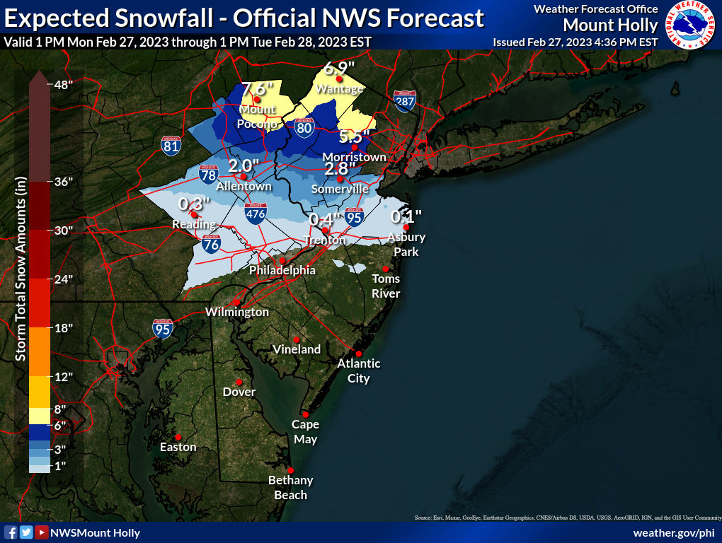
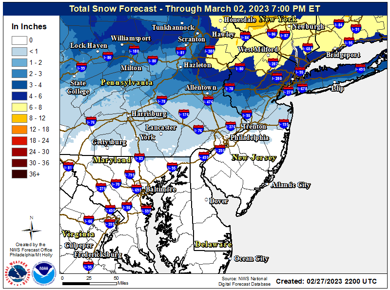
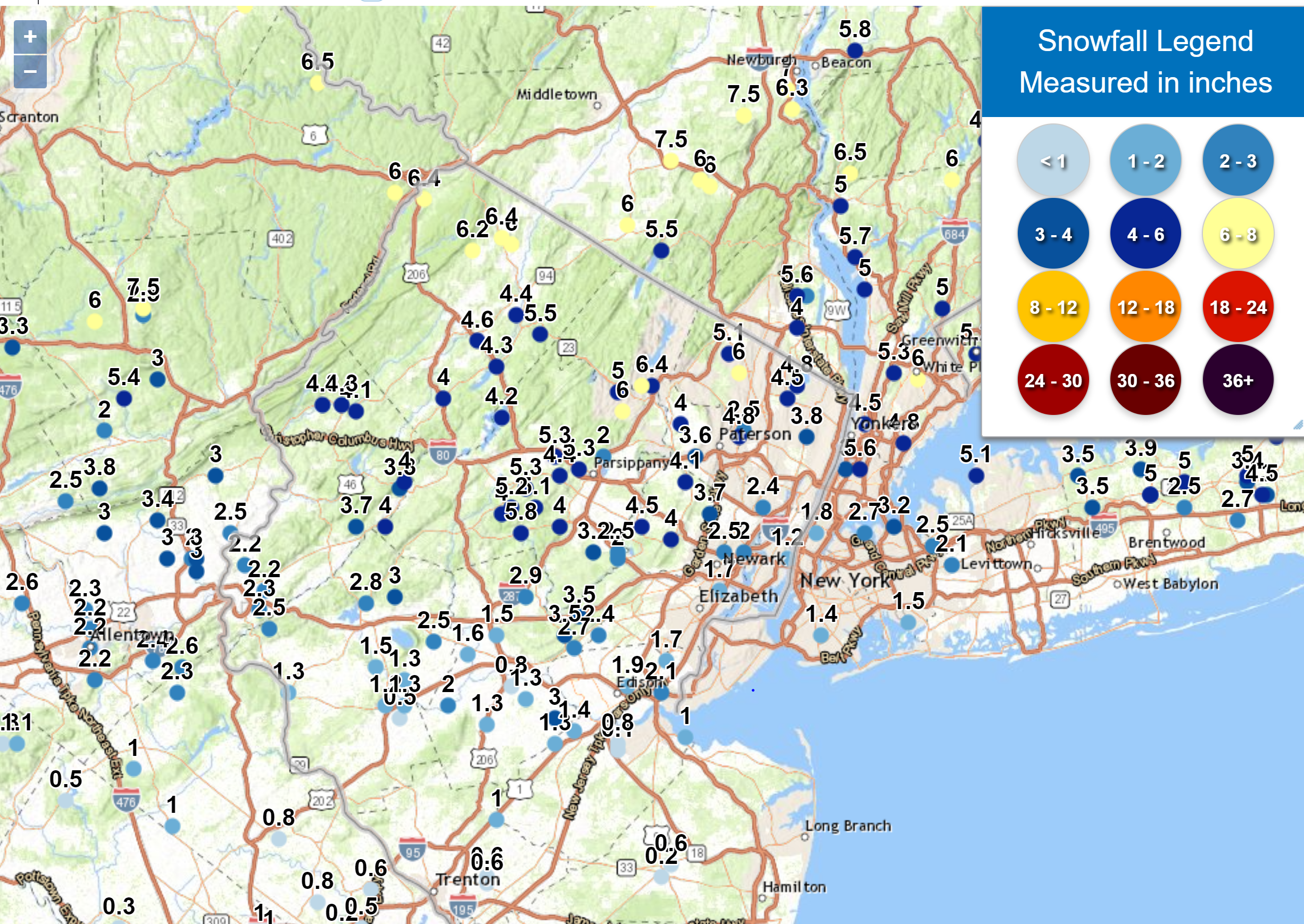
I'd say this was one of the best snowfall forecasts ever by the NWS, which is pretty easy to see from the graphic of reported snowfall vs the NWS predictions above (reproduced the regional one, below, as it includes NWS Philly and NYC forecasts). Areas along 78 generally got 2.5-3.5" with little to no rain but some sleet as predicted, areas along/N of 80 generally got 4-6" with all snow as predicted (even including the Bronx), while areas south of about Ewing to Perth Amboy generally got 1" or less, as predicted. And their prediction for my house in Metuchen was 2" and I got...wait for it...2".Well, at least the NWS addressed the discontinuities I discussed earlier (I had emailed them about it, as I'm sure many others did) between the Philly and NYC offices - this can be seen best in the 3rd graphic below showing the whole region. Specifically, the maps show 2-3" for northern Middlesex, adjacent to Union and SI, which also show 2-3" there, while northern Somerset now has 3-4", which is the same as western Union. For places getting 1-2" snow or less, most of the storm will likely be rain with maybe 1/2-3/4" of rain. No other major changes in the NWS maps, which also align pretty well with most media weather sources. Note that anywhere that gets 5"+ of fairly wet snow that clings to trees could see downed trees and power outages (most likely between 78 and 80; north of 80 the snow should be drier and temps will be below 32F).
Basically, there is going to be a sharp south to north gradient with <1" likely along 195/276 or SE of about the Middlesex/Monmouth border increasing to maybe 1-2" for central Bucks to southern Somerset to most of Middlesex, increasing to 3-4" along 78 and then to 4-6" along 80 and up to the Tappan Zee in the Hudson Valley and 5-8" north of there to 84 and beyond...and with 8-12" for most of the ski resorts in NY and New England. The NWS has 2-3" for most of southern NYC/southern LI to 3-5" for northern NYC (Bronx especially) and northern LI.
A few reminders: the heaviest precip will likely be from 7 pm to 3 am, where 6" of snow will likely fall for anyone who gets all snow, meaning an hour earlier changeover could cut an inch of snow, while an hour later could add an inch of snow. And with such steep gradients, predictions of snow could easily be off by 2-3" for locations south of 80, where the mixing with sleet and changeover to rain are expected, as accuracy of 1F is just very hard to achieve and that can make a huge difference. Could easily be the kind of storm with 1" in NB, 3" in Plainfield and 6" in Morristown, over just 20 miles - very hard to predict that accurately.
Also, while many are concerned about low ratio snow and melting, unless one is right where it's changing to sleet/rain, I think we'll get decent ratios (10:1 and better N of 78) for this one, with good lift and and expected good dendritic growth zone snow crystal growth, assuming the whole column stays at 32F or below (not a given). Also, the fact that the surface temp will likely be 33-34F south of 78 and in NYC will not matter much especially because there shouldn't be too much melting/aggregation going on in the last maybe 200-400' near the surface where it's 33-34F, i.e., for the most part, I suspect the crystal morphology, created in the DGZ, will remain largely unchanged. And keep in mind that at the actual surface, once the snowfall rate exceeds the melting rate (we'll have good rates for that), the temp of the "surface" i.e., the snow on the ground, is actually 32F, not 33-34F of the air, so much less melting goes on at the surface when one has a frozen layer on that surface. Lastly, all of the snow will fall at night, so there won't be any influence of the indirect sun.
Just started snowing here around 6 pm at 37F (was 42F just 90 minutes ago).
https://www.weather.gov/phi/
https://www.33andrain.com/topic/2129-feb-27-28-winter-storm-obsdiscussion/page/31/
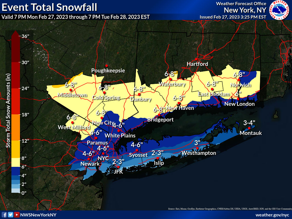
The only area their forecast was a bit low was some of NYC and adjacent NENJ, where there were predictions for 2-4/3-5" and most got 1-3" (at least for central/southern NYC and eastern Union/Esses and Hudson); the LI and Hudson Valley forecasts were also quite good, with ~2" on the south shore of LI up to 5" on the north shore, as predicted and 5-7" for most of the Hudson Valley as predicted. I still think the Central Park measurement of 1.8" was quite low, especially given LGA getting 2.7" (that's a hot topic on the weather boards since others in the CPK area reported up to 3").
The oxymoron was calling this a "significant" storm.
my comment stands
the forecast was for a minor storm.
it was a minor storm.
the snow fall was basically exactly within the ranges forecasted as shown above. impressively so.
how does that even remotely classify as a "massive bust"?
#'s choice to use the word "significant" in the title of this thread has no bearing on the topic of the accuracy of the forecast ... except to provide an opportunity, for the few who feel strangely compelled to give #'s shit, to call him for his word usage. these people need to get a life.
Last edited:
Similar threads
- Replies
- 472
- Views
- 18K
- Replies
- 131
- Views
- 5K
- Replies
- 74
- Views
- 2K
ADVERTISEMENT
ADVERTISEMENT