
Dan Zarrow update this AM: Sloppy, wintry weather for NJ Monday night: Shovels north, umbrellas south

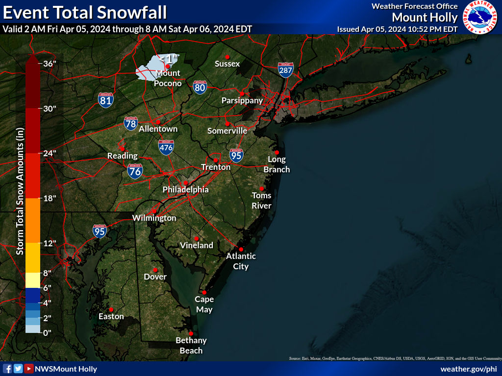
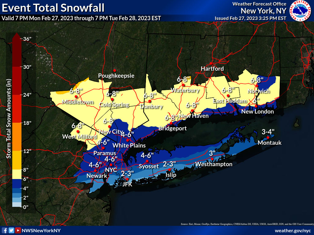
I'll admit, I was pleased to see my predictions for the NWS next forecast package coming largely to fruition, as they increased snowfall amounts along and south of 78, including the 95 corridor from NYC to at least New Brunswick, as well as addressed the inter-office discrepancies discussed above. The 3" line moved from about 80 down to 78, whereas this morning 78 was roughly a 1" snowfall line and the 1" line now is much further south, from about Ewing to Keyport. In addition, the 4" line is now a bit south of 80.
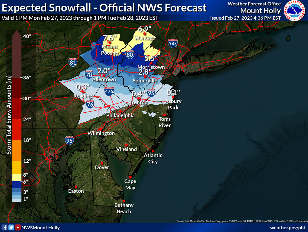
As a result, advisories have been posted by the NWS-Philly office for Monroe (Poconos) and Sussex for 4-6" of snow, for Northampton/Carbon (PA) and Warren/Morris for 3-5" of snow (including a bit of sleet), and for Berks/Upper Bucks, Hunterdon and Somerset for 1-3' of snow/sleet with a changeover to rain probable; all of these areas could also see a bit of freezing rain on top of the snow. The NWS-NYC posted advisories for 3-5" of snow for Western Union/Western Essex and Passaic, Bergen and Rockland/Westchester and points N of there (and for most of CT).
Significant snow probably holds off until after rush hour on Monday evening, but road conditions in the advisory areas will likely be a problem all night and for the Tuesday morning commute. Also, potentially heavy, wet snow (especially between 78 and 80 where mostly wet snow wil fall - it'll be drier N of 80 where it will be colder), if areas get 5-6" or more (possible), there could be scattered downed trees/power outages.
No advisories for the next tier of counties along/near the 95 corridor (including NENJ/NYC/LI) and down towards 195/276, but those areas are generally in the 1-2" swath, so some snow is forecast before the changeover to rain and there is still some upside on those snow numbers in some of the models at this point. Given how this winter has gone, I'll take 1-2" snow/sleet and then rain; I'm going with a guess of 2.5" for Metuchen. One last point: the precip will start near sunset on Monday and continue into the wee hours of Tuesday, meaning there will not be any snow accumulation issues related to indirect sunlight (snow may have a hard time sticking initially, though, since temps will be in the mid-30s when the precip starts.
https://www.weather.gov/phi/
https://www.americanwx.com/bb/topic/58901-22823-storm-threat/page/13/
Coming from the shore, so no problems expected until closer to EWRAll depends where she's coming from. If it's NW of EWR, could be an issue, if not, probably not much of an issue.
Since the heaviest precip should be over by 2-3 am, I would expect that even if EWR gets the 4-6" forecast by the NWS, it would be well plowed by sunrise on any major highways, plus temps will be above freezing by sunrise so melting will be going on, so I'm guessing the drive will be ok.Coming from the shore, so no problems expected until closer to EWR
Only for hapless morons such as yourself.^^^^^ Truth!
See, that's a perfect storm for me. Get to see some come down overnight and then it's off the roads by morning. What about the end of the week now?Since the heaviest precip should be over by 2-3 am, I would expect that even if EWR gets the 4-6" forecast by the NWS, it would be well plowed by sunrise on any major highways, plus temps will be above freezing by sunrise so melting will be going on, so I'm guessing the drive will be ok.
Did you actually miss the small book I wrote above around 11 am, with 3 graphics? :>)So, has tonight's storm just gone away, has nothing changed since this morning, or have our intrepid weather forecasters just been too busy to post any updates?
For most of NJ, it will be a nothing to nuisance event.So, has tonight's storm just gone away, has nothing changed since this morning, or have our intrepid weather forecasters just been too busy to post any updates?
Sorry numbers, I'm actually a big fan of your reports and read your 10:55 a.m. report with graphics carefully. I guess I was just hoping it might be time for an update - but I candidly admit that I don't remember when the Oz and 6z and 12z and 18z take place, etc. Thanks for all you do!Did you actually miss the small book I wrote above around 11 am, with 3 graphics?
What a change today! Depending on where you measure 4-7" of snow! Melting fast though.
id be shocked if newark gets 4-6Since the heaviest precip should be over by 2-3 am, I would expect that even if EWR gets the 4-6" forecast by the NWS, it would be well plowed by sunrise on any major highways, plus temps will be above freezing by sunrise so melting will be going on, so I'm guessing the drive will be ok.
Visiting. We come here 3-4 times per yearAre you living there or visiting?
Visiting. We come here 3-4 times per year
I dunno, it got pretty cold out there all of the sudden. Maybe things are trending colder and it over-performs?id be shocked if newark gets 4-6
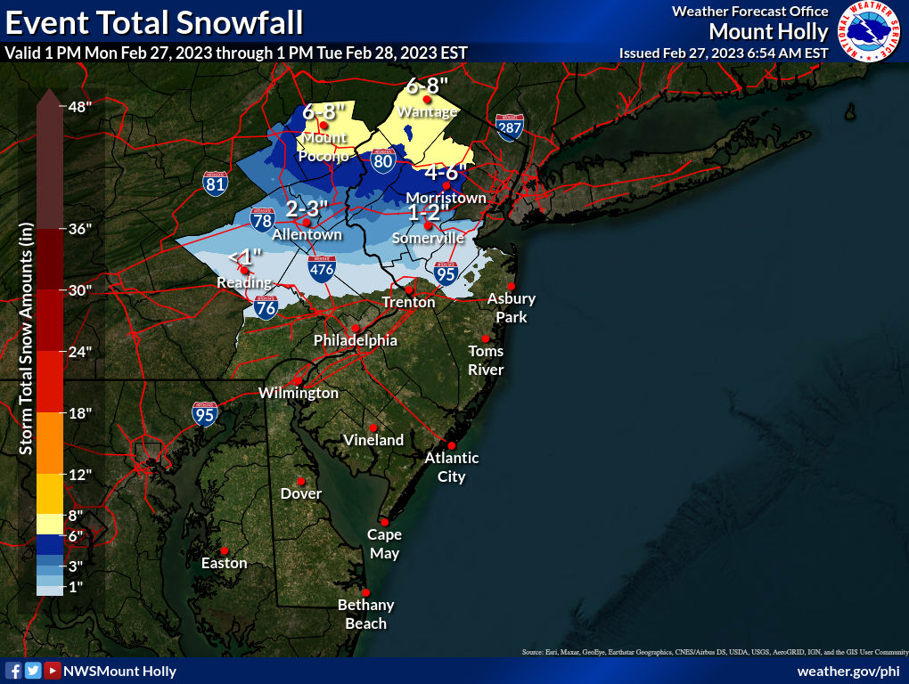
Not sure where you got that, but Morristown is predicted to be in the 3-6" range (5.5" on the latest map from the NWS). There will be significant snow on the roads there. I'll trade places with you...Thanks #'s. I'll plan on 1-3" here in Morristown.
Crap. I have to trek into the city tomorrow morning for a meeting.Not sure where you got that, but Morristown is predicted to be in the 3-6" range (5.5" on the latest map from the NWS). There will be significant snow on the roads there. I'll trade places with you...
Very complex forecast, especially for CNJ/areas S of 78. To illustrate, models are showing anywhere from 1" to 5" at my house in Metuchen and similar for most of the area S of 78 in NJ/NYC. Also, note that in areas that get 1-2" of snow, the snow will be folllowed up by up to 1/2" of rain, washing away most of the snow, especially with temps just above 32F S of 78. Precip should start by 5-7 pm with the heaviest precip through 4-5 am and much lighter after that.
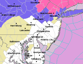
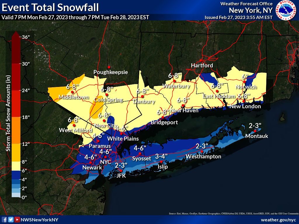
Updated NWS maps/guidances are out and they seem reasonable for areas along/N of 78, where 3-5" are forecast with 5-8" along and N of 80. Warnings (pink counties below) are up for 5-8" for Monroe, Sussex, Morris, Passaic, NW Bergen and the Hudson Valley N of NYC, while advisories (blue counties below) are up for Carbon, the Lehigh Valley and Warren for 3-6" of snow and for Upper Bucks, Hunterdon and Somerset for 2-4" (with southern parts of those counties likely getting the 2" and northern parts of those counties getting close to 4").
And the NWS-NYC has advisories up for 3-5" for Union, Essex, Hudson and the northern half of NYC/LI vs. 2-4" for the southern half of NYC (SI/Brooklyn, southern Queens) and the southern half of LI. And, of course, Middlesex County, especially the northern half, is adjacent to counties with advisories, but has none (this has happened many times before). Probably the biggest question for these snowfall forecasts is whether and to what extent sleet mixes in, as that could hold accumulations below forecast (although it's just as impactful from a snow removal/driving perspective, except for not being a visibility issue).
Given all of that it's almost impossible to predict what's going to happen in much of CNJ, south of 78, as it's the battleground for snow vs. rain with a difference of one degree F somewhere in the column several thousand feet up being the difference between areas that get 1" of snow then 1/2" of rain vs. areas that get 3" of snow then 1/4" of rain and the NWS and others are showing that difference over 5-10 miles from south to north in CNJ. A general 1-3" is a good guess, as many have, with the 3" near 78 and the 1" maybe 10-20 miles south of there, although several models have 1" down to 276/195 in PA/NJ.
To complicate matters, the NWS snowfall maps are essentially discontinuous in our area as often happens between offices. There's simply no way SI can be 2-3" down to the mouth of the Raritan and to have NE Middlesex County north of the Raritan, at least, at <1" into a narrow strip of 1-2" along Union County/SI, plus there's 1-2" in NW Middlesex up against 4-6" in Union County across the border to the north. I get they're thinking a pretty steep gradient from south to north, but I've never seen a gradient from 1" in Metuchen to 2" in Woodbridge to 3" in Rahway along the NJ Tpk over a 6 mile stretch, as per the point and clicks.
Finally, I'll stick with my 2.5" forecast for Metuchen, since every model is showing at least 2" for Metuchen with some up to 4-5", albeit with 1" or less not more than 10 mile south of here in some models. I guess we'll just see.
https://www.weather.gov/phi/
https://www.33andrain.com/topic/2129-feb-27-28-winter-storm-obsdiscussion/page/24/
Wednesday forecast for Sedona!Not sure where you got that, but Morristown is predicted to be in the 3-6" range (5.5" on the latest map from the NWS). There will be significant snow on the roads there. I'll trade places with you...
What’s going on out there? Thought you were trying to escape that mayhem?!Wednesday forecast for Sedona!
Wednesday
Snow. High near 40. Breezy, with a south wind 15 to 24 mph, with gusts as high as 37 mph. Chance of precipitation is 100%. New snow accumulation of 2 to 4 inches possible.
Wednesday Night
Snow, mainly before 11pm. The snow could be heavy at times. Low around 26. Southwest wind 9 to 18 mph becoming west after midnight. Winds could gust as high as 28 mph. Chance of precipitation is 80%. New snow accumulation of 2 to 4 inches possible.
A couple of mets said the sleet was likely due to lighter precip and poor snow growth up at ~15K feet and should flip to snow, as precip intensity increases and snow crystals grow better up around 15K feet, as it has over the last 15 minutes in most of EPA. All snow here now and falling decently with a coating on the ground.Have had off and on light snow with no accumulation, since it's still 36F (was 42F 2 hours ago, so it's dropping). Heavy precip looks to be getting close to SNJ/Mercer/Hunterdon with much of it is a sleet/snow mix and rain further south, so it's possible we'll see more sleet than expected in areas forecast to get snow, but it's hard to know how this will change as it reaches CNJ/NNJ. Should be some moderate to heavy precip in NJ in the next 10-15 min and for most of the rest of us including NENJ/NYC in 30-45 min.
It's the end of the world as we know it. Dinosaurs in Flagstaff using snowblowers. . . . .What’s going on out there? Thought you were trying to escape that mayhem?!

