You are Bac’s biggest ass-kisser on here it’s disgusting!
The two of you are the F’ing worst! If you don’t like to read the information numbers puts on here, then do us all a favor and just don’t read the sh*t!
I go to numbers’ post as my first source of snow forecasting, not to read you kissing Bactotherac’s ass every time he sh*ts all over a post by Numbers.
It’s simple man! Just don’t open the damn post! You only come on here to give him sh*t and it’s annoying as hell to those who just want to see the latest maps and predictions.


Colleges
- American Athletic
- Atlantic Coast
- Big 12
- Big East
- Big Ten
- Colonial
- Conference USA
- Independents (FBS)
- Junior College
- Mountain West
- Northeast
- Pac-12
- Patriot League
- Pioneer League
- Southeastern
- Sun Belt
- Army
- Charlotte
- East Carolina
- Florida Atlantic
- Memphis
- Navy
- North Texas
- Rice
- South Florida
- Temple
- Tulane
- Tulsa
- UAB
- UTSA
- Boston College
- California
- Clemson
- Duke
- Florida State
- Georgia Tech
- Louisville
- Miami (FL)
- North Carolina
- North Carolina State
- Pittsburgh
- Southern Methodist
- Stanford
- Syracuse
- Virginia
- Virginia Tech
- Wake Forest
- Arizona
- Arizona State
- Baylor
- Brigham Young
- Cincinnati
- Colorado
- Houston
- Iowa State
- Kansas
- Kansas State
- Oklahoma State
- TCU
- Texas Tech
- UCF
- Utah
- West Virginia
- Illinois
- Indiana
- Iowa
- Maryland
- Michigan
- Michigan State
- Minnesota
- Nebraska
- Northwestern
- Ohio State
- Oregon
- Penn State
- Purdue
- Rutgers
- UCLA
- USC
- Washington
- Wisconsin
High School
- Illinois HS Sports
- Indiana HS Sports
- Iowa HS Sports
- Kansas HS Sports
- Michigan HS Sports
- Minnesota HS Sports
- Missouri HS Sports
- Nebraska HS Sports
- Oklahoma HS Sports
- Texas HS Hoops
- Texas HS Sports
- Wisconsin HS Sports
- Cincinnati HS Sports
- Delaware
- Maryland HS Sports
- New Jersey HS Hoops
- New Jersey HS Sports
- NYC HS Hoops
- Ohio HS Sports
- Pennsylvania HS Sports
- Virginia HS Sports
- West Virginia HS Sports
ADVERTISEMENT
Install the app
How to install the app on iOS
Follow along with the video below to see how to install our site as a web app on your home screen.
Note: This feature may not be available in some browsers.
You are using an out of date browser. It may not display this or other websites correctly.
You should upgrade or use an alternative browser.
You should upgrade or use an alternative browser.
OT: Significant Winter Storm Likely on Thursday (2/18)
- Thread starter RU848789
- Start date

Yeah, but you know that things are going to change back and forth until you get within 48-72 hours, so why make an issue out of it?im talking about mid range....4-6 days before...lotta hype for nothing


how much is snow and how much is sleet is always a concern...I think 4-8/6-10 are good starting points depending where everyone is
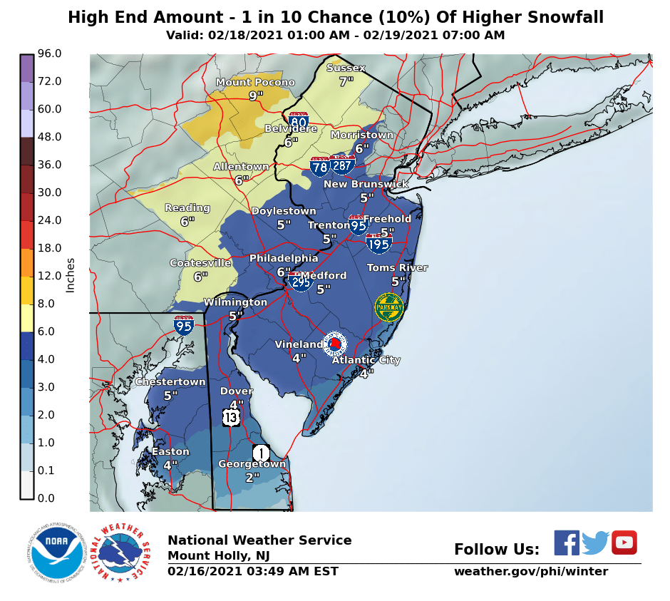
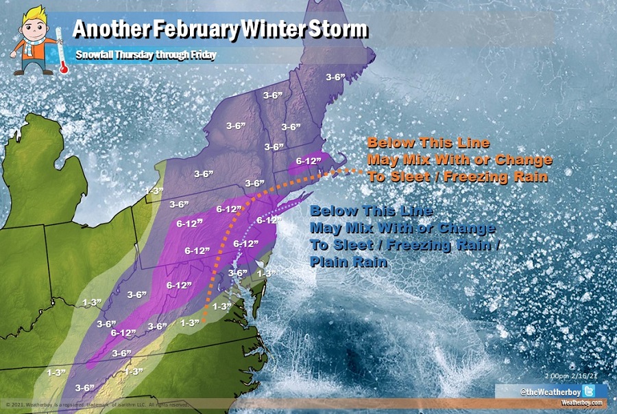
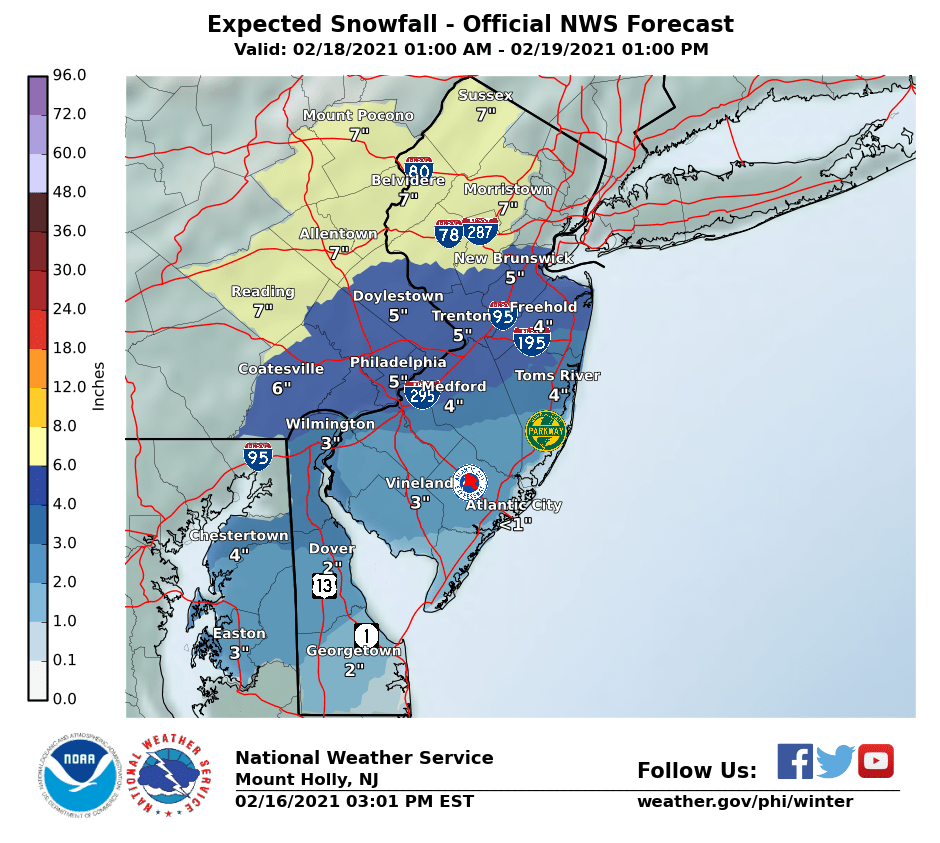
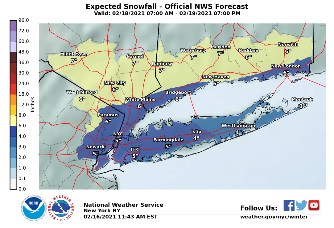
Briefly, all of the 12Z models show roughly 4-8/6-10" for the vast majority of the Philly-NJ-NYC region for Thursday from sunrise through early Friday; some of that may be sleet, which won't change the mass, but will change the depth. Too far out to predict who gets sleet and how much, but sleet is most likely along and SE of 95. Should see updated NWS maps at 4 pm along with winter storm watches for most. Things could still change, but this is what the models are showing, overall, now.NWS issued snowfall maps, below, with a general 4-6" of snow for most and 6-8" for NWNJ/Poconos/Lehigh Valley, starting around sunrise on Thursday and lasting through the evening. In their discussion, they talk a fair amount about a front end thump of snow, followed by a potential mix or changeover to sleet as far NW as the 95 corridor and maybe even inland of that a bit - as we saw for 12/16, that's very difficult to predict, as is the best banding for snow, but with a track just off the coast, the best banding is often in our NW areas, inland of 95. There's also a risk of a changeover to plain rain, especially near/along the coast (and especially south of 195).
The other big question is how much precip do we get? Most models are showing around 1" of liquid equivalent meaning most of the precip would be snow/sleet, at least along and NW of 95, Still 48 hours out from the start of the event, so changes are clearly still possible, which is why it's not worth diving too deeply into the details of the models or the NWS forecast yet. Suffice it to say that the NWS said they'll likely be issuing warnings at 4 pm, unless there is some major shift in the 12Z models coming out shortly. And FYI, the 12Z NAM just came out and backed off the insane 2"+ of precip from last night with 1-1.5" of precip and almost all of it frozen along and NW of 95 (i.e., (6-12" of snow/sleet with a bit of freezing rain at the end, early Friday) - closer to the other models last night (which are more like 4-8" snow/sleet for most).
https://www.weather.gov/phi/
Last edited:
Currently trading at 1.21 United States Dollars.So, how's the Euro looking about now?
You are Bac’s biggest ass-kisser on here it’s disgusting!
The two of you are the F’ing worst! If you don’t like to read the information numbers puts on here, then do us all a favor and just don’t read the sh*t!
I go to numbers’ post as my first source of snow forecasting, not to read you kissing Bactotherac’s ass every time he sh*ts all over a post by Numbers.
It’s simple man! Just don’t open the damn post! You only come on here to give him sh*t and it’s annoying as hell to those who just want to see the latest maps and predictions.
perfectly said! What a troll!
12z euro is in and it has a similar look as the nam with 4-8+ inches for Thur/Fri. Euro interestingly enough keeps it all snow for most of the storm. The trend this season has been for storms to come more north than modeled... will this one break that pattern?

NWS issued snowfall maps, below, with a general 4-6" of snow for most and 6-8" for NWNJ/Poconos/Lehigh Valley, starting around sunrise on Thursday and lasting through the evening. In their discussion, they talk a fair amount about a front end thump of snow, followed by a potential mix or changeover to sleet as far NW as the 95 corridor and maybe even inland of that a bit - as we saw for 12/16, that's very difficult to predict, as is the best banding for snow, but with a track just off the coast, the best banding is often in our NW areas, inland of 95. There's also a risk of a changeover to plain rain, especially near/along the coast (and especially south of 195).
The other big question is how much precip do we get? Most models are showing around 1" of liquid equivalent meaning most of the precip would be snow/sleet, at least along and NW of 95, Still 48 hours out from the start of the event, so changes are clearly still possible, which is why it's not worth diving too deeply into the details of the models or the NWS forecast yet. Suffice it to say that the NWS said they'll likely be issuing warnings at 4 pm, unless there is some major shift in the 12Z models coming out shortly. And FYI, the 12Z NAM just came out and backed off the insane 2"+ of precip from last night with 1-1.5" of precip and almost all of it frozen along and NW of 95 (i.e., (6-12" of snow/sleet with a bit of freezing rain at the end, early Friday) - closer to the other models last night (which are more like 4-8" snow/sleet for most).
https://www.weather.gov/phi/
Briefly, all of the 12Z models show roughly 4-8/6-10" for the vast majority of the Philly-NJ-NYC region for Thursday from sunrise through early Friday; some of that may be sleet, which won't change the mass, but will change the depth. Too far out to predict who gets sleet and how much, but sleet is most likely along and SE of 95. Should see updated NWS maps at 4 pm along with winter storm watches for most. Things could still change, but this is what the models are showing, overall, now.
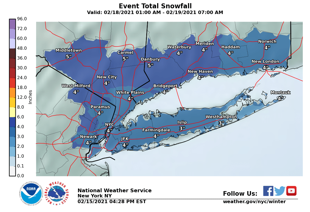
As expected, the NWS in Philly issued watches for the entire 95 corridor up to SE Bucks/Montco in PA and Mercer/Middlesex in NJ for 3-6" of snow and for all points NW of there in NNJ/NE PA for 5-8" of snow, as less mixing is expected NW of 95; watches were not issued for SENJ, since there's too much uncertainty over mixing/changeover to sleet and maybe rain. The NWS-NYC simply issued blanket watches for their entire area for 4-8" of snow (that includes Union up to Bergen in NJ, NYC, LI, and SENY/SWCT. Snow should start around sunrise Thursday and go through at least early Friday morning before sunrise. Updated maps are below.
https://www.weather.gov/phi/
Lee Goldberg said that he had to check further before committing to any totals.
90 days ago,Accu-Weather called this storm to hit on the 17th,so they just missed by a day.I checked that out back then because of a doctor's appointment that I have tomorrow morning.
90 days ago,Accu-Weather called this storm to hit on the 17th,so they just missed by a day.I checked that out back then because of a doctor's appointment that I have tomorrow morning.
I like this one a lot. I suspect 10-12" totals across N and maybe CNJ
Again, CNJ is going to get the worst of it. Just shoot me.
I picked the wrong winter for my snowblower to break down. The auger crank broke, and I can’t get the part. Sigh.
I shouldn't... but I will.It looks like the wet heavy stuff
That's what she said.
NWS:
A *new* Winter Storm Watch is now in effect for Thursday and Friday. For more details, check:


A *new* Winter Storm Watch is now in effect for Thursday and Friday. For more details, check:
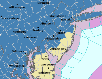
Right on cue the National Weather Service has issued a Winter Storm Watch for Thursday's storm for everyone highlighted in blue. A general 4-8+ inches is expected. Models have so far continued to shift south or hold storm position which would limit any mixing

So it's your fault!I picked the wrong winter for my snowblower to break down. The auger crank broke, and I can’t get the part. Sigh.
I shouldn't... but I will.
That's what she said.
You have a sheep that talks?
You are Bac’s biggest ass-kisser on here it’s disgusting!
The two of you are the F’ing worst! If you don’t like to read the information numbers puts on here, then do us all a favor and just don’t read the sh*t!
I go to numbers’ post as my first source of snow forecasting, not to read you kissing Bactotherac’s ass every time he sh*ts all over a post by Numbers.
It’s simple man! Just don’t open the damn post! You only come on here to give him sh*t and it’s annoying as hell to those who just want to see the latest maps and predictions.
BAC and T2K ... perfect together. Dumb and Dumber
They haven't seen the 18Z NAM, lol. Likely overdone, but it picks up better on mesoscale banding vs. the global models - probably shows the ceiling for this storm. Also note that that model doesn't show sleet at all, so areas south of 195 will still likely be getting significant sleet, which is still impactful (2" of snow and 1" of sleet is the same mass as 5" of snow).I like this one a lot. I suspect 10-12" totals across N and maybe CNJ

Last edited:

I did, actually. But alas, she was abused by an unknown assailant during a Halloween party. She speaks no more.You have a sheep that talks?
Maybe take off the muzzle...I did, actually. But alas, she was abused by an unknown assailant during a Halloween party. She speaks no more.
For me I come to this board to read #'s forecasts. Even my family asks me to check the forecast on the Rutgers board because we are big skiers. With that said I know he "wish-casts" for snow so he is the optimist. Bac is the realist and in my opinion is usually more correct. A great example was last weekend. If I listened to the mainstream forecast, no way I drive up to Hunter Mt. last Sunday AM. Read this board and got up early and hit the road. No snow on the way up. Flurries while I was there. No snow on the way home until the NJ border. Live in Bergen so minimal impact (had about 7-8 inches of fluffy snow). It was a great day to ski and I would have missed it if not for this board.

Yes- and Bac is a great poster on these threads when he chooses not to go into ball busting mode.For me I come to this board to read #'s forecasts. Even my family asks me to check the forecast on the Rutgers board because we are big skiers. With that said I know he "wish-casts" for snow so he is the optimist. Bac is the realist and in my opinion is usually more correct. A great example was last weekend. If I listened to the mainstream forecast, no way I drive up to Hunter Mt. last Sunday AM. Read this board and got up early and hit the road. No snow on the way up. Flurries while I was there. No snow on the way home until the NJ border. Live in Bergen so minimal impact (had about 7-8 inches of fluffy snow). It was a great day to ski and I would have missed it if not for this board.
Not going to speak for Bac, but I think it's the "wish-casting" that makes him that way. I appreciate the opposing perspectives. I actually like when those 2 go back and forth. Just not a fan of everyone else just in the thread just to bust balls. This is where the Current Events board impacts the regular boards.Yes- and Bac is a great poster on these threads when he chooses not to go into ball busting mode.
Well, I mean, as you know, she got deflated. And thus tossed in the garbage. 😢Maybe take off the muzzle...
I have to disagree there and this is coming from someone who hates snow. I think numbers puts all the possibilities on the table from high to low end based on the models. Haven’t met #s in person but have met bac (where else but at the RAC) and he’s a good dude. Just likes busting weather balls. When you filter out the noise, this is some of the best info out there.Not going to speak for Bac, but I think it's the "wish-casting" that makes him that way. I appreciate the opposing perspectives. I actually like when those 2 go back and forth. Just not a fan of everyone else just in the thread just to bust balls. This is where the Current Events board impacts the regular boards.
I have no problem with the give & take between #s and bac. Bac knows his weather. It’s all the other noise from the trolls who make these threads unbearable.

Off topic, but this map annoys me. The size of the text is typically associated with the size of a city. Bigger cities, bigger font.
Using that logic on this map you’d think that Pittsburgh is bigger than Philadelphia and Cleveland, or that Binghamton is bigger than Syracuse, or that Richmond is bigger than Norfolk, or that Raleigh is bigger than Charlotte, or that Buffalo is bigger than Toronto.
I’m probably the only person on earth annoyed by this but thanks for listening to this complaint.
I have no problem with the give & take between #s and bac. Bac knows his weather. It’s all the other noise from the trolls who make these threads unbearable.
This sums it up perfectly.
Looks like it is pushing to the north. Too bad! :)
Similar threads
- Replies
- 62
- Views
- 2K
- Replies
- 608
- Views
- 18K
OT: Minor to Moderate (2-4?) Snowfall Likely Sat morning (2/17); will be <32F, so expect slick roads
- Replies
- 213
- Views
- 5K
- Replies
- 592
- Views
- 16K
- Replies
- 771
- Views
- 20K
ADVERTISEMENT
Latest posts
-
-

-
FB Recruiting Rutgers strikes in North Carolina again, landing 2025 LB Isaiah Deloatch
- Latest: William J. Leggett
-

ADVERTISEMENT