ADVERTISEMENT

OT: Hurricane Ian to Bring Major to Catastrophic Impacts to Cuba/Florida (and 2022 Tropical Weather Thread):

I just got a message from my sister in Cape Coral. Everyone's OK.
Serious roof damage and the neighborhood looks like a war zone. No power or water right now.
Also said there was looting at the local Home Depot and 7-11.
She wanted to know if she can take advantage of those free plane rides to Martha's Vineyard that their governor is offering.
Funny, what position does she play?

 
  • Like
Reactions: newell138
I have a friend that just moved to Florida a little over a month ago. Evidently there is a 30 day waiting period for your home owners insurance to take effect (not sure if that’s just the storm related portions). His policy became active 4 days ago. Cutting it a little close.
 
You're mostly wrong on this too. If you're simply talking about localized waves hitting dunes that's very different from a surge (which is not the waves - it's the baseline ocean level going up) where the water on the ocean and bay side, which are generally continuous for barrier islands, rises 10 feet, for example, everywhere on that barrier island below 10 feet above normally dry ground will be inundated from a little to up to 10 feet. Period. Of course I'm being a bit simplistic, since to go into all of the gory details would require a lot more time, math and physics and my training in those is not a "hobby" - pretty sure I know those fundamental sciences far better than almost anyone, especially on a message board. And it's not just an animation - have you seen the footage of live flooding and subsequent damage of the barrier islands that were totally inundated
I'm not looking to argue. Just sharing reality. We have 4-6 ft storm surges in the area. St. Augustine is flooded downtown with a 9 ft elevation. Jacksonville Beach and Ponte Vedra are bone dry even in the lowest of areas.

This all rose out of a question on flood insurance and the damages done by wind vs flood. Your animations would imply flood is the issue when in reality it is quite the opposite. Flood damage from storm surge does not occur like annimated.

Below is the picture of Hurricane Matthew storm surge higher than my elevation breaching the dunes a mere 100 yds away. We didn't get a drop of water. Maybe because the winds were coming from the west at this time and pushing the water out of the intracoastal and St, Johns River allowing this water to drain into the much lower intracoastal..

Hurricane-Matthew-Florida-677963.jpg
 
Last edited:
Fort Meyers
Fd1hlKlXoAcb0k6
As an FYI - none of these homes will collect a penny from flood insurance. Its all likely viewed as wind damage.

Only way to collect from flood insurance is if there is no damage to the structure and water intruded from the ground up.
 
  • Like
Reactions: Knightmoves
As an FYI - none of these homes will collect a penny from flood insurance. Its all likely viewed as wind damage.

Only way to collect from flood insurance is if there is no damage to the structure and water intruded from the ground up.
I think the insurance companies will find it politically untenable not to pay out.
 
I think the insurance companies will find it politically untenable not to pay out.
Not at all. If you have damage to the structure, then it is wind damage that likely covers. I'm just sharing because so many people are confused about flood insurance and the government subsidy.
 
  • Like
Reactions: newell138 and pmvon
Not at all. If you have damage to the structure, then it is wind damage that likely covers. I'm just sharing because so many people are confused about flood insurance and the government subsidy.
Storm surge? A wall of water could have dealt the fatal "blow." Regardless, have to think those homes had Federal Flood Insurance, although I believe there is a cap on the coverage, likely less than the value of the structure/s.
 
I was curious about what DeSantis actually said when he voted against Sandy Aid in 2013. This was the most I could find. I am interested to understand the fuller context on his big switch from against disaster aid to now for disaster aid.

A DeSantis quote from another article
The problem with the Sandy package was, if you look at it, only 30 percent of it was going to be spent in the first two years," DeSantis said in an interview recently at his St. Augustine office. "It actually appropriated money out to 2020 and 2021, things that could not in any way be said to be emergency spending. It just was so much extraneous stuff."

Would he vote against disaster relief if a hurricane hit his district?

"If a hurricane came here, I would want any relief plan to be fiscally responsible," he said. " would not want to add extra things and say that because this is a vehicle that's moving, let's try to Christmas tree it out."
 
Whereabouts?

My Parent’s house was in Veronawalk right off of Collier. Wondering how the area made out.
My friend Bob lives in Veronawalk. He said there’s no flooding and no wind damage to the units. He did say that there are down palm trees and he has no power.
 
  • Like
Reactions: rurichdog
Okay experts.. what am I seeing in this radar image.. Ian is near Georgia now... is that the jet stream stealing its moisture and sending it all teh way to Ireland/UK on way to Norway? And is that stuff down around the ABC islands going to form a hurricane too?
Ian-after-Florida-Near-Georgia.jpg
 
  • Like
Reactions: RU-05
My friend Bob lives in Veronawalk. He said there’s no flooding and no wind damage to the units. He did say that there are down palm trees, and he has no power.
Thanks.

I swear that lifestyle and that location helped my Dad make it to 92 and Mom is still kicking at 89.
 
Folks, may I suggest we drop the debate about emergency spending? None of us want this thread locked. Let's stick to talking about the forecast and about what is happening on the ground.
So you’re saying there should be a thread just for this particular event. Great idea.👍
 
Sorry, but the first part is mostly wrong. Water is essentially "continuous" meaning it will equalize its height by flowing from the source of rising water (the ocean in this case of surge) to areas on land that are normally dry and connected areas like inlets, bays and intracoastal areas. If the water rises 10 feet across the board from what it normally is at, say, high tide, that water will flood anywhere on land that is less than 10 feet in height above that high tide line, so if your house is 11 feet above that level, you'll still be a foot above the rising water, but a house at 6 feet above that high tide level will have 4 feet of flooding in this scenario.

Just look at the animation below, which shows the difference between normal water levels in Naples and the modeled credible worst case water levels in Naples after 12 feet of surge, showing vast majorities of the area under at least some water (some places have a foot of water, while others have 5 feet or more). In the 10 foot surge scenario I discussed above, only places above 10 feet won't flood, which is why they always only evacuate low lying areas, below the predicted worst surge and not everyone else, since they're above the surge level. Of course, low/high tides affect these numbers as does the additive effect of 1-2 feet of rainfall.

With regard to inland areas, both wind and flooding from torrential rains are very impactful, as large areas can become inundated and flooded when there are these incredible 10-20" rainfall amounts in a short time. You are correct, however, that wind can impact everyone and cause all kinds of damage - and lead to significant water damage from falling rain if a roof is damaged or windows broken (but that's really due to wind). One other complicating factor from an insurance perspective is that storm surge from a tropical storm is typically not covered by flood insurance - only surge flooding from hurricanes is, which is why it was such a big deal that Sandy was classified as extratropical (and not a hurricane) at landfall, meaning many people had difficulty getting coverage for surge flooding (iirc, this was later corrected for most, as some friends have told me, but in some cases it took years).


Also, here's the USGS elevation map, which one can use to check the elevation of any point in the US. If one zooms in on these coastal areas of SW FL, it's clear that large areas are at less than 10 feet of elevation, which is why the 10-15' storm surges observed for many areas produced such catastrophic flooding.

https://en-us.topographic-map.com/maps/c3a/Fort-Myers/
One small problem, Professor. According to boots on the ground reports, that predicted catastrophic flooding in the Naples area didn't pan out that way. And according to the topographic map posted in the same post, you'd need 30+ feet of storm surge to flood hakfway to Lake Okeechobee as predicted...
 
  • Like
Reactions: BigEastPhil
I'm not looking to argue. Just sharing reality. We have 4-6 ft storm surges in the area. St. Augustine is flooded downtown with a 9 ft elevation. Jacksonville Beach and Ponte Vedra are bone dry even in the lowest of areas.

This all rose out of a question on flood insurance and the damages done by wind vs flood. Your animations would imply flood is the issue when in reality it is quite the opposite. Flood damage from storm surge does not occur like annimated.

Below is the picture of Hurricane Matthew storm surge higher than my elevation breaching the dunes a mere 100 yds away. We didn't get a drop of water. Maybe because the winds were coming from the west at this time and pushing the water out of the intracoastal and St, Johns River allowing this water to drain into the much lower intracoastal..

Hurricane-Matthew-Florida-677963.jpg
I think you're just using flawed logic to explain your observations. I don't doubt at all that Jacksonville Beach and Ponte Vedra experience very little flooding from4-6 feet of storm surge, because they're not narrow barrier islands and the elevations for both areas go from essentially 0 ft at the ocean to 10 feet or more within about a block of the beach, presumably due to dunes and the natural elevation, since a few blocks inland from the ocean both areas are 15+ feet, so there's no reason those locations would ever flood from a 4-6 foot surge above normal high tide level. Also, the intracoastal is 1-2 miles inland of those locations and that intracoastal is also at 0 feet elevation (same as the ocean as they're closely connected) and if there's 4-6 feet of surge that goes into that intracoastal (and the St. John's River nearby), that's also not going to flood Jacksonville Beach or Ponte Vedra from the backside, since the elevation from the intracoastal also goes up quite quickly to 10'+ a few blocks towards those locations.

With regard to St. Augustine, your comment that a location that is at 9 feet of elevation floods from 4-6 foot surge simply makes no sense, as that can't be enough to flood an area that high in elevation. Also, just cruising around on the USGS elevation site, it looks like almost all of downtown St. Augustine is above 10 feet, except right at the very edges by the ocean and the intracoastal, so I would think a 4-6 foot surge wouldn't result in much flooding beyond the immediate coast. This is in contrast to what we just saw throughout SW FL, where the various barrier islands and decent sections of inland residential areas along inlets and estuaries are mostly <10 feet - and those areas likely experienced 10-20 feet of storm surge, given how much flooding was observed.

https://en-us.topographic-map.com/maps/c3a/Fort-Myers/

At this point we don't have great measurements of the surge yet, but I did come across a report of 18 feet of storm surge in Punta Gorda and Port Charlotte, which means that was likely the amount throughout that area, probably including Captiva, Sanibel, Ft. Myers Beach, etc (which probably were even a bit higher, as they're closer to the ocean - yes, there is some gradient moving from the ocean to inland even in water, just like there is in a river - that gradient is needed to overcome the friction from the ground to allow flow). That's biblical storm surge and the footage proves it.

https://earthsky.org/earth/hurricane-ian-september-2022-florida-us-east/
 
One small problem, Professor. According to boots on the ground reports, that predicted catastrophic flooding in the Naples area didn't pan out that way. And according to the topographic map posted in the same post, you'd need 30+ feet of storm surge to flood hakfway to Lake Okeechobee as predicted...
Not sure what you're trying to say - there was catastrophic surge flooding in Naples, as seen in countless videos/pics, presumably in the locations generally less than 10-12 feet in elevation as the surge was likely in that range (it was 18 feet in Punta Gorda, as I just posted and with Naples further away from Ian's center, one would think the surge would be less at Naples - that's a guess - haven't seen a reliable report of surge from there yet). Also, I don't recall anyone saying there would be surge halfway to Okeechobee, but it's worth noting that the lake is at about 10 feet in elevation and is connected to the GOM via Ft. Myers and a river from there to the lake, so in theory, the 18' of surge in the Ft. Myers area could have led to some surge well up river.
 
Well, got back from my late night at the Borgata in the wee hours and just woke up; was at least able to keep up with events last night via my phone and this thread and the one on AmericanWx. Crazy day and night for Florida - hopefully the death toll isn't too high - 5 confirmed deaths as of now, but unfortunately that number is expected to go up, perhaps considerably, given the number of desparate 911 calls received that couldn't be responded to in the midst of the storm. Not going to rehash what has gone on so far, but figured an update on Ian's forecast from here on was in order.

Ian


Ian Impacts

Well, got back from my late night at the Borgata in the wee hours and recently woke up; was at least able to keep up with events last night via my phone and this thread and the one on AmericanWx. Crazy day and night for Florida - hopefully the death toll isn't too high - 5 confirmed deaths as of now (first link below), but unfortunately that number is expected to go up, perhaps considerably, given the number of desperate 911 calls received that couldn't be responded to in the midst of the storm.

https://www.telegraph.co.uk/world-n...ida-latest-news-tracker-tropical-storm-path1/

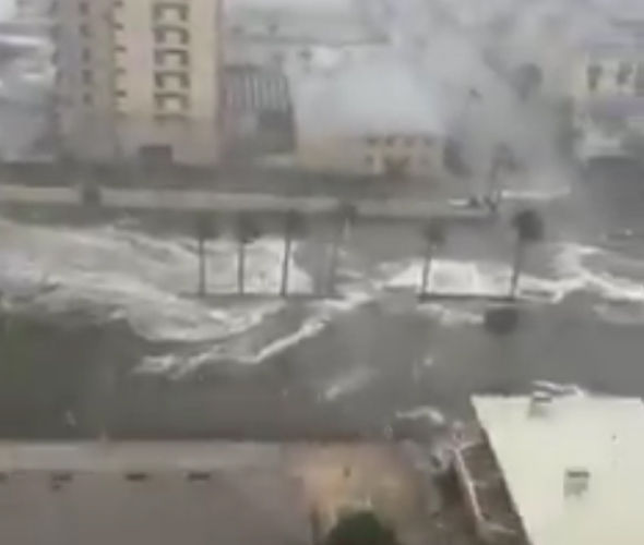
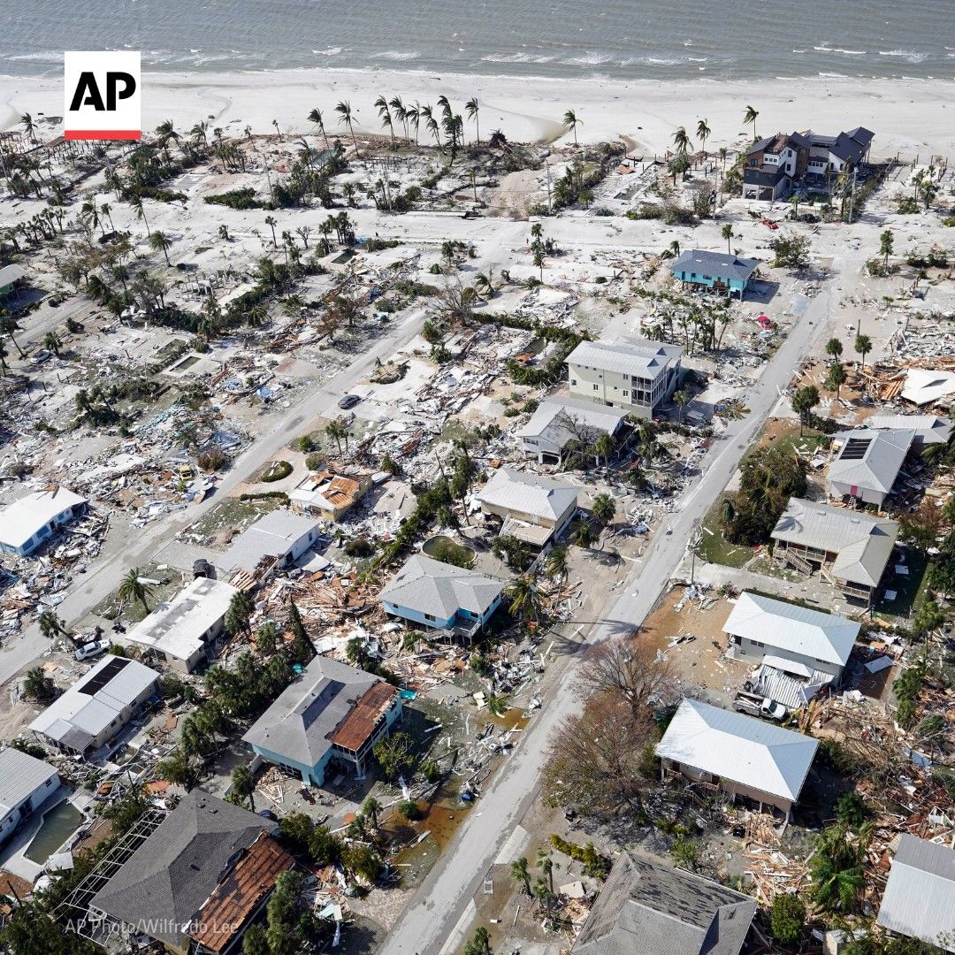
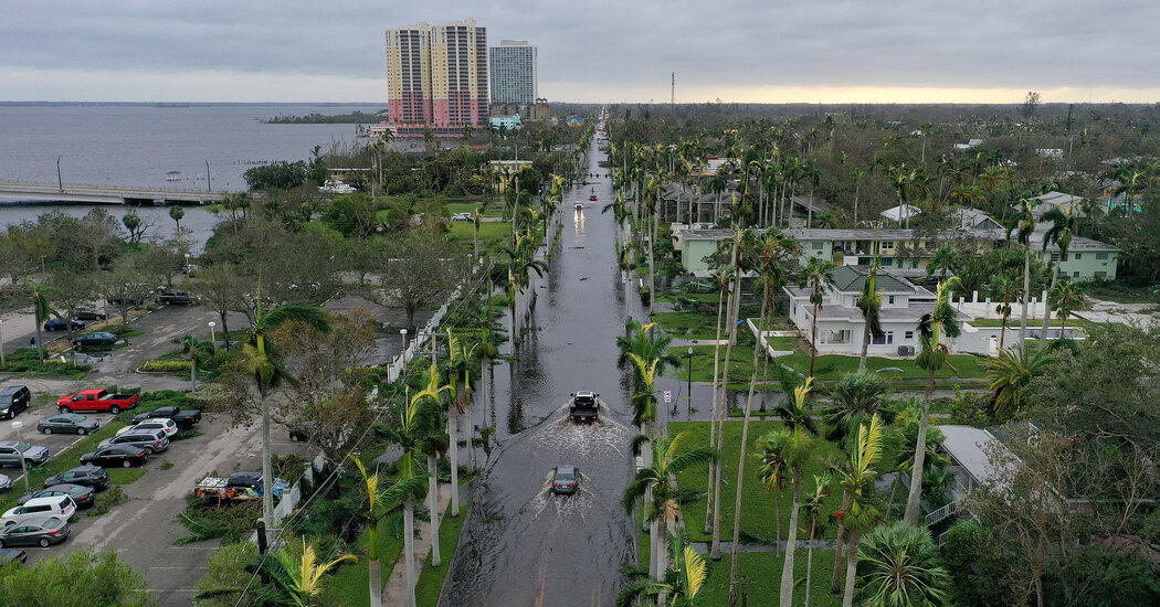
Between the incredible storm surges from about Englewood down to Marco Island and the 10-20" of rain through a wide swath of central Florida, mostly along and NW of the track (Tampa to Orlando to Daytona for example), the flooding has just been catastrophic for so many. In addition, of course, the incredible winds near landfall and even inland, as Ian weakened very slowly (possibly due to the "brown ocean effect" discussed last night) brought devastation to many, as did the 100+ small tornadoes observed. Given all that and the over 2 million "customers" (so likely 4-5 million people) without power in FL, Ian is likely to become the most expensive hurricane in history. Not going to rehash, in detail, what has gone on so far, although the 2nd link has some excellent videos on the impact from all over Florida and the 3rd link has a nice overview of storm impacts.

https://www.wpbf.com/article/videos-hurricane-ian/41433985#

https://www.nytimes.com/live/2022/09/29/us/hurricane-ian-florida

Ian Forecast:

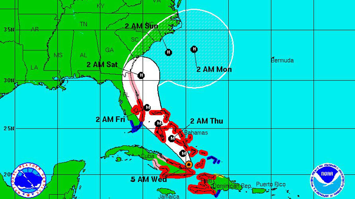
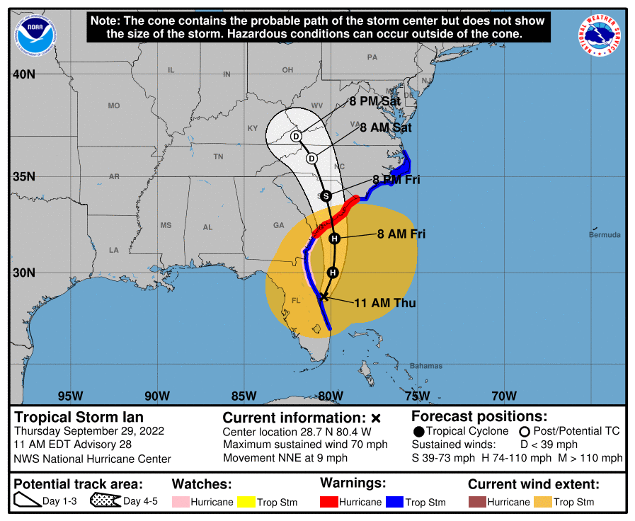
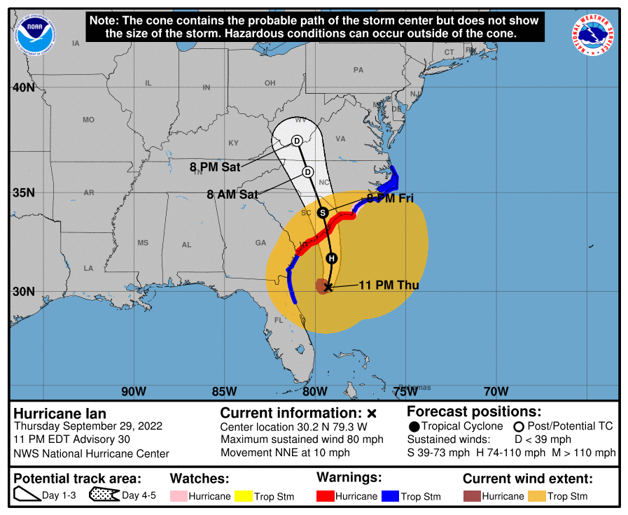
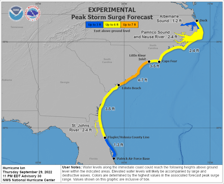
Since Ian moved more quickly across Florida than expected and with a further SE than forecast track, this means the "starting point" for Ian's next phase is as a stronger storm (spent ~12 hours less over land) which will head further north. This means that Ian still has 70 mph winds as it has emerged north of Cape Canaveral (vs. yesterday's forecast of north of Daytona late Thursday night) and is now expected to become a hurricane with 75-80 mph winds as it curves towards another landfall around Charleston Friday morning (vs. yesterday's forecast of near Savannah as a 50 mph TS).

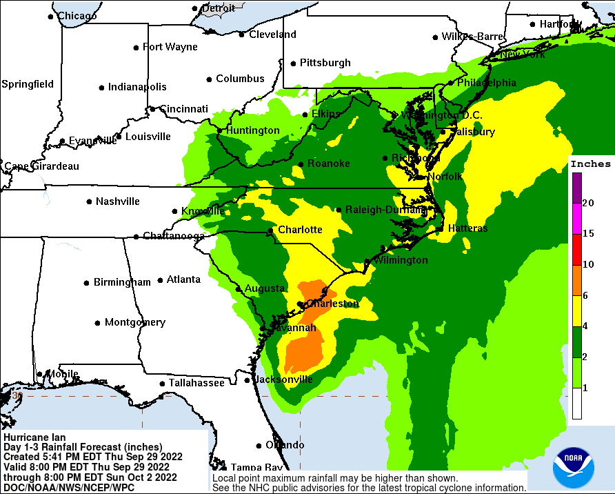
Looking ahead, Ian is expected to continue heading NE for a bit, but to then bend back NW towards Charleston, given interactions with the approaching trough/front along the SE US - this interaction has also led to Ian becoming somewhat of a "hybrid" cyclone with a combination of tropical and non-tropical characteristics, especially the large swaths of precipitation well to the NW of the storm (more like a cold core low pressure system), which will continue, bringing heavy rains well inland of its track and into the mid-Atlantic.

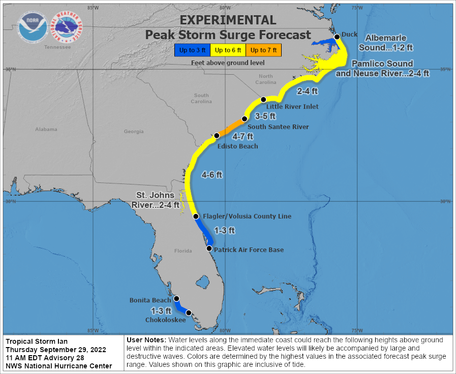
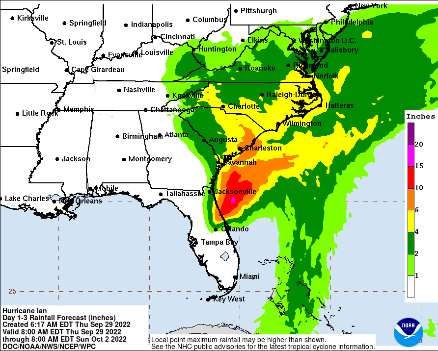
Ian will NOT regain strength beyond Cat 1, like it had, but still a Cat 1 hurricane is going to have significant impacts to the SE coast with storm surges in the 3-5/4-7 foot range, which could lead to substantial flooding, especially to the NE of the track (so Charleston should hope for the track to be NE of the city which would provide offshore winds, greatly reducing surge). While there will be some wind damage along the coast, by far, the greatest threat is the surge damage. There will also likely be 4-8" rainfall amounts in much of SC/NC along the coast and somewhat inland as Ian dissipates in western NC by Saturday, which will lead to some inland flooding. Several inches of rain are also likely up through VA/MD/DE and possibly even 1-2" in our area, especially near the coast.

FORECAST POSITIONS AND MAX WINDS

INIT 29/1500Z 28.7N 80.4W 60 KT 70 MPH
12H 30/0000Z 30.0N 79.9W 65 KT 75 MPH
24H 30/1200Z 31.8N 79.8W 65 KT 75 MPH
36H 01/0000Z 34.0N 80.3W 45 KT 50 MPH...INLAND
48H 01/1200Z 35.9N 81.1W 30 KT 35 MPH...POST-TROP/EXTRATROP
60H 02/0000Z 37.0N 82.0W 15 KT 15 MPH...POST-TROP/EXTRATROP
72H 02/1200Z...DISSIPATED

b1xuxwh.png


JyxLyuR.png


JPaZ6cQ.gif

Ian regained hurricane status at 5 pm with 75 mph winds and they're now up to 85 mph, as the storm is moving towards landfall along the SC coast in about 18 hours, when the forecast calls for an 85 mph hurricane (it's not expected to strengthen much at all due to shear). As we've seen all along for Ian, the actual track keeps being a bit south or east of the forecast track and that is continuing, as landfall is now forecast to be about 50 miles NE of Charleston, as opposed to being very close to Charleston 12 hours ago.

That is a significant relief for Charleston, if it verifies, as it now ought to mostly experience offshore winds as Ian approaches, which should limit surge. However, the surge forecasts weren't decreased yet, as I'm guessing the NHC doesn't want to have people there let their guard down, since the track could shift back closer to Charleston. But surges in NE SC and SW NC could easily be in the 4-7' predicted - likely not catastrophic, except for low-lying areas.

As Ian moves inland, the winds will not die down that quickly, partly because Ian has become a bit of a hybrid storm based on interactions with the stalled frontal system in the SE US (which runs up to our area), so it's not deriving all of its energy from ocean water evaporation (getting some from baroclinic sources, i.e., the gradient from warm to cold air masses, as we see with most lows in our area, including nor'easters). Hence TS force winds are expected a couple of hundred miles inland in SC and NC, as well as heavy rains with 4-8" forecast.

For our area, the main issue is just the rain from a combination of Ian's remnants (which will dissipate in western VA) and that stalled front which extends up to our area. We could get 2-4" along the coast and in SNJ/DE and 1-2" along the 95 corridor, but much less well NW - and we can use the rain, which will mostly fall on Saturday into Sunday.

https://www.nhc.noaa.gov/graphics_at4.shtml?start#contents

aPexTQB.png


0FkUPiv.png


UKerB1X.gif
 
Folks, may I suggest we drop the debate about emergency spending? None of us want this thread locked. Let's stick to talking about the forecast and about what is happening on the ground.
Agreed. It's certainly an interesting topic, but it derails this thread and is starting to get a bit chippy, which could lead to mod action. Maybe it should be in a separate thread.
 
  • Like
Reactions: thegock


Good explanation of Flood insurance, glad to see FEMA changed some of their guidelines but sad to see homeowners drop their insurance due to the rise of insurance premiums.

Lot of people going to move out of Florida after they lose their home.
 
Last edited:


Good explanation of Flood insurance, glad to see FEMA changed some of their guidelines but sad to see homeowners drop their insurance due to the rise of insurance premiums.

Lot of people going to move out of Florida after they lose their home.
Did Rutgers have Flood insurance to cover multiple years of Flood damage? Or were you referring to flood insurance? 😉
 
I think you're just using flawed logic to explain your observations. I don't doubt at all that Jacksonville Beach and Ponte Vedra experience very little flooding from4-6 feet of storm surge, because they're not narrow barrier islands and the elevations for both areas go from essentially 0 ft at the ocean to 10 feet or more within about a block of the beach, presumably due to dunes and the natural elevation, since a few blocks inland from the ocean both areas are 15+ feet, so there's no reason those locations would ever flood from a 4-6 foot surge above normal high tide level. Also, the intracoastal is 1-2 miles inland of those locations and that intracoastal is also at 0 feet elevation (same as the ocean as they're closely connected) and if there's 4-6 feet of surge that goes into that intracoastal (and the St. John's River nearby), that's also not going to flood Jacksonville Beach or Ponte Vedra from the backside, since the elevation from the intracoastal also goes up quite quickly to 10'+ a few blocks towards those locations.

With regard to St. Augustine, your comment that a location that is at 9 feet of elevation floods from 4-6 foot surge simply makes no sense, as that can't be enough to flood an area that high in elevation. Also, just cruising around on the USGS elevation site, it looks like almost all of downtown St. Augustine is above 10 feet, except right at the very edges by the ocean and the intracoastal, so I would think a 4-6 foot surge wouldn't result in much flooding beyond the immediate coast. This is in contrast to what we just saw throughout SW FL, where the various barrier islands and decent sections of inland residential areas along inlets and estuaries are mostly <10 feet - and those areas likely experienced 10-20 feet of storm surge, given how much flooding was observed.

https://en-us.topographic-map.com/maps/c3a/Fort-Myers/

At this point we don't have great measurements of the surge yet, but I did come across a report of 18 feet of storm surge in Punta Gorda and Port Charlotte, which means that was likely the amount throughout that area, probably including Captiva, Sanibel, Ft. Myers Beach, etc (which probably were even a bit higher, as they're closer to the ocean - yes, there is some gradient moving from the ocean to inland even in water, just like there is in a river - that gradient is needed to overcome the friction from the ground to allow flow). That's biblical storm surge and the footage proves it.

https://earthsky.org/earth/hurricane-ian-september-2022-florida-us-east/
Again all good. But maybe you can explain the simulations you shared from Twitter showing expected massive flooding in areas that have elevations much higher than the storm surge ever was or expected to be. On another note just skip it.

personally I just got done cleaning up and fixing the fence that blew away. We were lucky.. As expected the 50 hours of wind destroyed the beaches in NE Florida. I’ve seen pics of 10-15 foot drops offs at the end of people’s yards. Heading up now.
 
ADVERTISEMENT