
Smart move, some body got to help them out or go to a nursing home. I rather kill myself than go to a nursing home.Same here, it was in Naples.
My Parents just got too old to be that far away all by themselves. Moved back up to be closer to family.
Colleges
- American Athletic
- Atlantic Coast
- Big 12
- Big East
- Big Ten
- Colonial
- Conference USA
- Independents (FBS)
- Junior College
- Mountain West
- Northeast
- Pac-12
- Patriot League
- Pioneer League
- Southeastern
- Sun Belt
- Army
- Charlotte
- East Carolina
- Florida Atlantic
- Memphis
- Navy
- North Texas
- Rice
- South Florida
- Temple
- Tulane
- Tulsa
- UAB
- UTSA
- Boston College
- California
- Clemson
- Duke
- Florida State
- Georgia Tech
- Louisville
- Miami (FL)
- North Carolina
- North Carolina State
- Pittsburgh
- Southern Methodist
- Stanford
- Syracuse
- Virginia
- Virginia Tech
- Wake Forest
- Arizona
- Arizona State
- Baylor
- Brigham Young
- Cincinnati
- Colorado
- Houston
- Iowa State
- Kansas
- Kansas State
- Oklahoma State
- TCU
- Texas Tech
- UCF
- Utah
- West Virginia
- Illinois
- Indiana
- Iowa
- Maryland
- Michigan
- Michigan State
- Minnesota
- Nebraska
- Northwestern
- Ohio State
- Oregon
- Penn State
- Purdue
- Rutgers
- UCLA
- USC
- Washington
- Wisconsin
High Schools
- Illinois HS Sports
- Indiana HS Sports
- Iowa HS Sports
- Kansas HS Sports
- Michigan HS Sports
- Minnesota HS Sports
- Missouri HS Sports
- Nebraska HS Sports
- Oklahoma HS Sports
- Texas HS Hoops
- Texas HS Sports
- Wisconsin HS Sports
- Cincinnati HS Sports
- Delaware
- Maryland HS Sports
- New Jersey HS Hoops
- New Jersey HS Sports
- NYC HS Hoops
- Ohio HS Sports
- Pennsylvania HS Sports
- Virginia HS Sports
- West Virginia HS Sports
ADVERTISEMENT
You are using an out of date browser. It may not display this or other websites correctly.
You should upgrade or use an alternative browser.
You should upgrade or use an alternative browser.
OT: Hurricane Ian to Bring Major to Catastrophic Impacts to Cuba/Florida (and 2022 Tropical Weather Thread):
- Thread starter RU848789
- Start date

I hope they increase flood insurance by 15-20% for the next 5 years. I’m tire of paying for these people moving to Florida. I was even thinking about buying something down there but I’m smarter.It's almost as if some of these places shouldn't be developed.
Been texting with the parents in East Naples. They're fine, condo is fine. No flooding by them besides low-lying areas that drain poorly on a good day. No power obviously.
Whereabouts?Been texting with the parents in East Naples. They're fine, condo is fine. No flooding by them besides low-lying areas that drain poorly on a good day. No power obviously.
My Parent’s house was in Veronawalk right off of Collier. Wondering how the area made out.
He said he took his car to high ground - high enough? We shall see.Except the cars
Just heard from buddy who's on the east coast barrier island in Melbourne Beach, here's what he shared:
Ian just passed us and now we're in tropical storm conditions but we truly dodged a bullet. The yard is completely trashed but no damage to the house, the gazebo, the pump house, the tool shed or the Jeep...even though it was covered completely with shredded plants and trees. Also we never lost power. We were very lucky there because many in our subdivision have been without power since yesterday...two of them our neighbors 2 and 3 houses down the street. It's still very windy and we're under a flash flood emergency with over half the area flooded. The winds and rains are expected to continue all day, and once Ian gets out into the Atlantic everyone on the east coast need to keep an eye on it. The west coast truly got hammered and right now the estimate is that there are at least 200 fatalities. The recovery in this area will take years.
CountrysideWhereabouts?
My Parent’s house was in Veronawalk right off of Collier. Wondering how the area made out.
Hope everyone is faring well. I keep thinking of Humphrey Bogart tying himself to a tree as he rode out the hurricane in Key Largo.
Last edited:
Spoke to my father in Tarpon Springs this morning. He said it was rainy and windy thats it for him. The power flickered a few times but they never lost it. He did mention that next time he will evacuate though. I guess he saw the damage by constantly watching the news. Smart move IMO
What strikes me is the wide path of damage in FL and the pending second landfall in SC then the move in upcountry SC and then into western NC.
But in FL as a focus, where is the "manpower" going to come from to do all the debris removal, rebuilding, etc.?
The labor just is not available, and then there's the needed equipment and materials, and associated inflated costs.
That's a whole second wave of devastation to come.
But in FL as a focus, where is the "manpower" going to come from to do all the debris removal, rebuilding, etc.?
The labor just is not available, and then there's the needed equipment and materials, and associated inflated costs.
That's a whole second wave of devastation to come.
50 foot section of the causeway has been destroyed (see pic in above post).
The island probably was inundated, mostly if not completely. The surge would have receded by now, but there is no way to get vehicles on or off the island until the causeway is repaired.
Very little of the overall damage is caused by water. Vast majority is covered under the wind policy which us Floridians pay a boatload for. Thanks for the concern.I hope they increase flood insurance by 15-20% for the next 5 years. I’m tire of paying for these people moving to Florida. I was even thinking about buying something down there but I’m smarter.
Sanibel Causeway lot worse than that original photo i saw (that i think was posted here)
Maybe Martha's Vineyard can send some people down to help that are looking for work? :)What strikes me is the wide path of damage in FL and the pending second landfall in SC then the move in upcountry SC and then into western NC.
But in FL as a focus, where is the "manpower" going to come from to do all the debris removal, rebuilding, etc.?
The labor just is not available, and then there's the needed equipment and materials, and associated inflated costs.
That's a whole second wave of devastation to come.
Anyways is this supposed to strengthen back to a hurricane when it leaves FL and hits the Atlantic again before moving to SC?
Yes. Hurricane again already. Cat 1.Maybe Martha's Vineyard can send some people down to help that are looking for work? :)
Anyways is this supposed to strengthen back to a hurricane when it leaves FL and hits the Atlantic again before moving to SC?
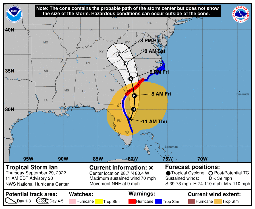
Well, got back from my late night at the Borgata in the wee hours and just woke up; was at least able to keep up with events last night via my phone and this thread and the one on AmericanWx. Crazy day and night for Florida - hopefully the death toll isn't too high - 5 confirmed deaths as of now, but unfortunately that number is expected to go up, perhaps considerably, given the number of desparate 911 calls received that couldn't be responded to in the midst of the storm. Not going to rehash what has gone on so far, but figured an update on Ian's forecast from here on was in order.
Ian
Ian Impacts
Well, got back from my late night at the Borgata in the wee hours and recently woke up; was at least able to keep up with events last night via my phone and this thread and the one on AmericanWx. Crazy day and night for Florida - hopefully the death toll isn't too high - 5 confirmed deaths as of now (first link below), but unfortunately that number is expected to go up, perhaps considerably, given the number of desperate 911 calls received that couldn't be responded to in the midst of the storm.
https://www.telegraph.co.uk/world-n...ida-latest-news-tracker-tropical-storm-path1/
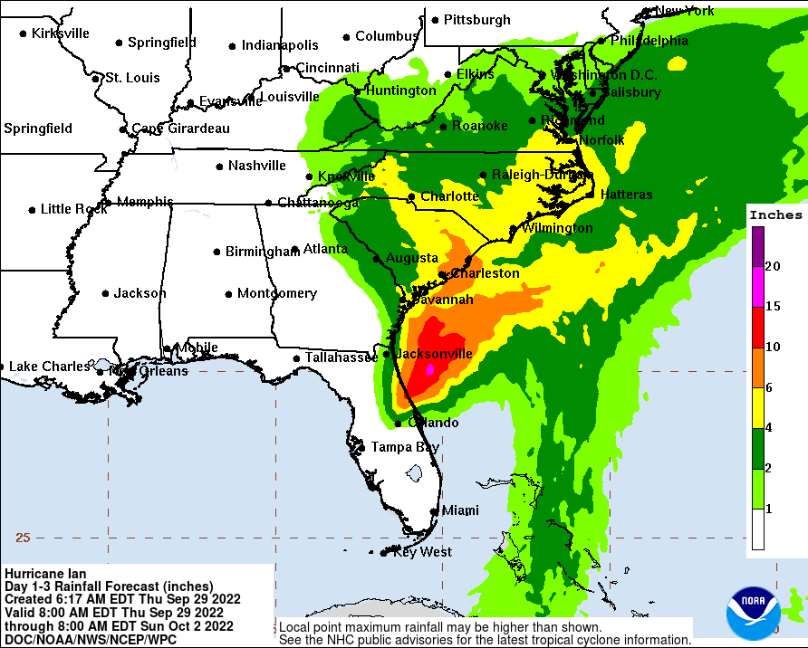
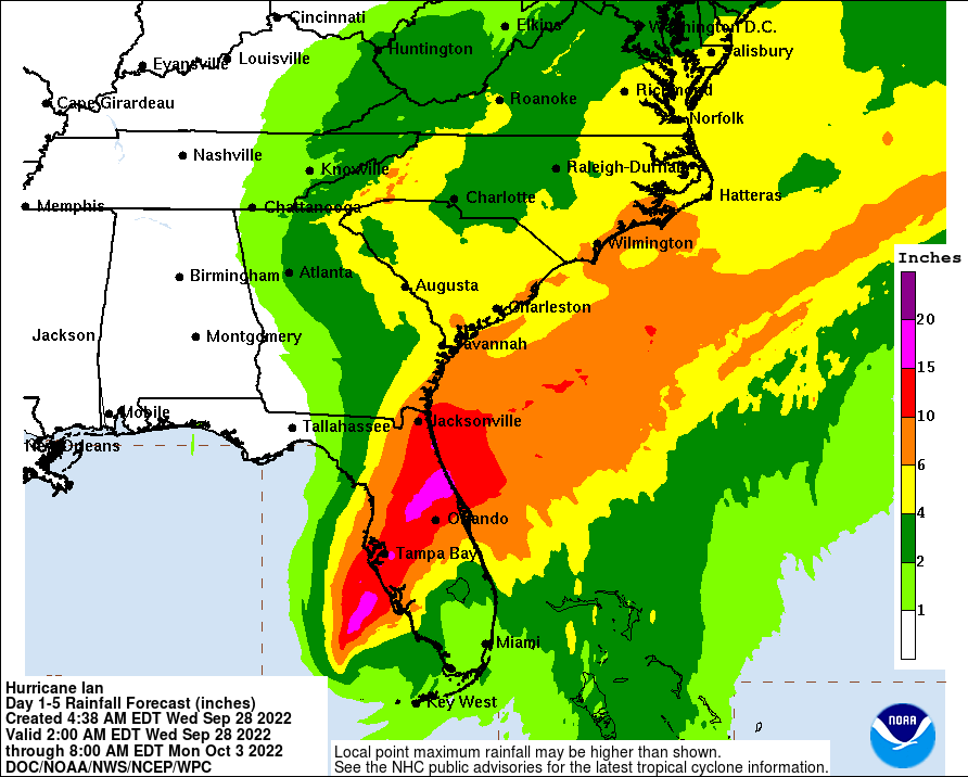
Between the incredible storm surges from about Englewood down to Marco Island and the 10-20" of rain through a wide swath of central Florida, mostly along and NW of the track (Tampa to Orlando to Daytona for example), the flooding has just been catastrophic for so many. In addition, of course, the incredible winds near landfall and even inland, as Ian weakened very slowly (possibly due to the "brown ocean effect" discussed last night) brought devastation to many, as did the 100+ small tornadoes observed. Given all that and the over 2 million "customers" (so likely 4-5 million people) without power in FL, Ian is likely to become the most expensive hurricane in history. Not going to rehash, in detail, what has gone on so far, although the 2nd link has some excellent videos on the impact from all over Florida and the 3rd link has a nice overview of storm impacts.
https://www.wpbf.com/article/videos-hurricane-ian/41433985#
https://www.nytimes.com/live/2022/09/29/us/hurricane-ian-florida
Ian Forecast:
Since Ian moved more quickly across Florida than expected and with a further SE than forecast track, this means the "starting point" for Ian's next phase is as a stronger storm (spent ~12 hours less over land) which will head further north. This means that Ian still has 70 mph winds as it has emerged north of Cape Canaveral (vs. yesterday's forecast of north of Daytona late Thursday night) and is now expected to become a hurricane with 75-80 mph winds as it curves towards another landfall around Charleston Friday morning (vs. yesterday's forecast of near Savannah as a 50 mph TS).
Looking ahead, Ian is expected to continue heading NE for a bit, but to then bend back NW towards Charleston, given interactions with the approaching trough/front along the SE US - this interaction has also led to Ian becoming somewhat of a "hybrid" cyclone with a combination of tropical and non-tropical characteristics, especially the large swaths of precipitation well to the NW of the storm (more like a cold core low pressure system), which will continue, bringing heavy rains well inland of its track and into the mid-Atlantic.
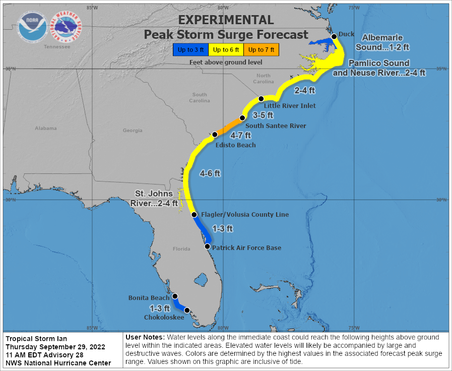
Ian will NOT regain strength beyond Cat 1, like it had, but still a Cat 1 hurricane is going to have significant impacts to the SE coast with storm surges in the 3-5/4-7 foot range, which could lead to substantial flooding, especially to the NE of the track (so Charleston should hope for the track to be NE of the city which would provide offshore winds, greatly reducing surge). While there will be some wind damage along the coast, by far, the greatest threat is the surge damage. There will also likely be 4-8" rainfall amounts in much of SC/NC along the coast and somewhat inland as Ian dissipates in western NC by Saturday, which will lead to some inland flooding. Several inches of rain are also likely up through VA/MD/DE and possibly even 1-2" in our area, especially near the coast.
FORECAST POSITIONS AND MAX WINDS
INIT 29/1500Z 28.7N 80.4W 60 KT 70 MPH
12H 30/0000Z 30.0N 79.9W 65 KT 75 MPH
24H 30/1200Z 31.8N 79.8W 65 KT 75 MPH
36H 01/0000Z 34.0N 80.3W 45 KT 50 MPH...INLAND
48H 01/1200Z 35.9N 81.1W 30 KT 35 MPH...POST-TROP/EXTRATROP
60H 02/0000Z 37.0N 82.0W 15 KT 15 MPH...POST-TROP/EXTRATROP
72H 02/1200Z...DISSIPATED
Ian
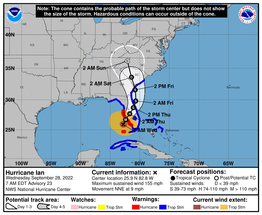
Given the 6:35 am upgrade of Ian to 155 mph and the new graphics/forecast put out by the NHC, I decided to delete my post from about 20 minutes ago and replace it with this one to avoid confusion...
𝗜𝗮𝗻 𝘂𝗽 𝘁𝗼 𝟭𝟱𝟱 𝗺𝗽𝗵 𝗻𝗼𝘄 - 𝘁𝗵𝗶𝘀 𝗶𝘀 𝗮𝗻 𝗲𝘅𝘁𝗿𝗮𝗼𝗿𝗱𝗶𝗻𝗮𝗿𝗶𝗹𝘆 𝗱𝗮𝗻𝗴𝗲𝗿𝗼𝘂𝘀 𝘀𝘁𝗼𝗿𝗺.
Unfortunately for FL, Ian strengthened significantly after completing its eyewall replacement cycle overnight, going from 120 mph at 11 pm to 140 mph as of 5 am and then to 155 mph as of 6:35 am, as the NHC just put out an emergency update with that new information from a hurricane hunter flight. Pressure has dropped from 952 mbar to 942 mbar overnight and then dropped to 936 mbar as of the 6:35 am update, linked below.
https://www.nhc.noaa.gov/.../MIATCUAT4+shtml/280955.shtml?
This is now a very strong Cat 4 hurricane and almost a cat 5 hurricane (157 mph) and unlikely to weaken much in the next 12-15 hours before landfall, which is currently forecast to be in the Cape Haze/Boca Grande barrier island area and then inland, heading NNE, about 5-10 miles west of the Port Charlotte/Punta Gorda area (a minor shift of 5-10 miles NW of the 11 pm track, as Ian made a northward wobble overnight); this track would be about 20-25 miles NW of Captiva and Fort Myers and about 40-50 miles NW of Naples.
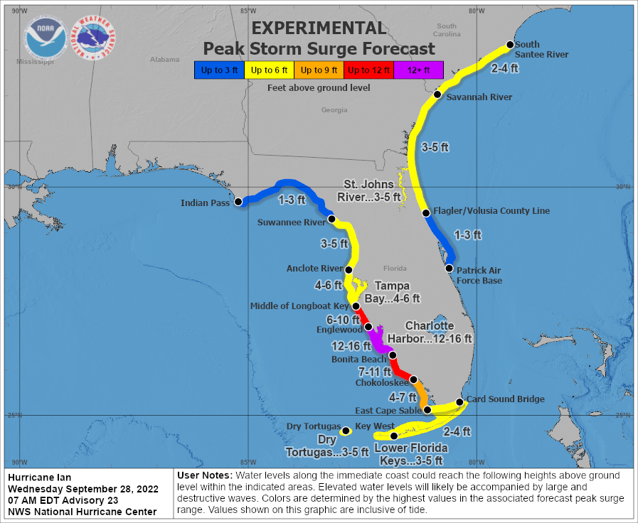
The storm surge forecast was also updated, given the upgraded strength of the storm, increasing storm surge forecasts by a few feet across the board from landfall and south of there with 12-16' of storm surge now predicted from Englewood to Bonita Beach and 7-11' from Bonita Beach to just south of Marco Island. This is very bad.
Note that hurricane force winds extend about 40 miles from the center of the storm and tropical storm force winds extend about 175 miles from the center of the storm. If this track verifies, Naples/Marco Island would be spared the worst of the winds, but not the worst of the storm surge, as per the NHC surge forecast. And to make matters worse, both the GFS and Euro models show the storm slowing down in its path across Florida, taking about 36 hours to go from landfall to just north of Daytona Beach, exacerbating the already torrential amount of rainfall forecast to fall (10-15" and locally up to 20" across a large swath of FL, including Tampa, Orlando and JAX). And there have already been dozens of small tornadoes with many more to come, especially along and on the right side of the storm's track.
Beyond that, Ian will emerge off the NE FL coast, likely still as a tropical storm with 50 mph winds and then head up the coast and back onto land somewhere around Savannah, GA on Friday afternoon, before dissipating to a remnant low by the time it reaches Spartanburg, SC late Saturday night and moisture from the system and a secondary low, which will move towards DelMarVa will likely bring heavy rain (2-4" possible) to DelMarVa and probably SNJ from late Saturday into Monday, with maybe 1-2" of rain for CNJ/NNJ/NYC area (could be much drier, could be wetter - high uncertainty on rainfall for our area).
https://www.nhc.noaa.gov/text/refresh/MIATCPAT4+shtml/280856.shtml?
FORECAST POSITIONS AND MAX WINDS
INIT 28/1100Z 25.9N 82.8W 135 KT 155 MPH
12H 28/1800Z 26.7N 82.4W 135 KT 155 MPH
24H 29/0600Z 27.7N 81.7W 80 KT 90 MPH...INLAND
36H 29/1800Z 28.7N 81.1W 50 KT 60 MPH...INLAND
48H 30/0600Z 29.8N 80.7W 45 KT 50 MPH...OVER WATER
60H 30/1800Z 31.6N 80.8W 45 KT 50 MPH
72H 01/0600Z 33.6N 81.4W 30 KT 35 MPH...INLAND
96H 02/0600Z 36.1N 82.1W 25 KT 30 MPH...POST-TROP/INLAND
120H 03/0600Z...DISSIPATED
Ian Impacts
Well, got back from my late night at the Borgata in the wee hours and recently woke up; was at least able to keep up with events last night via my phone and this thread and the one on AmericanWx. Crazy day and night for Florida - hopefully the death toll isn't too high - 5 confirmed deaths as of now (first link below), but unfortunately that number is expected to go up, perhaps considerably, given the number of desperate 911 calls received that couldn't be responded to in the midst of the storm.
https://www.telegraph.co.uk/world-n...ida-latest-news-tracker-tropical-storm-path1/
Between the incredible storm surges from about Englewood down to Marco Island and the 10-20" of rain through a wide swath of central Florida, mostly along and NW of the track (Tampa to Orlando to Daytona for example), the flooding has just been catastrophic for so many. In addition, of course, the incredible winds near landfall and even inland, as Ian weakened very slowly (possibly due to the "brown ocean effect" discussed last night) brought devastation to many, as did the 100+ small tornadoes observed. Given all that and the over 2 million "customers" (so likely 4-5 million people) without power in FL, Ian is likely to become the most expensive hurricane in history. Not going to rehash, in detail, what has gone on so far, although the 2nd link has some excellent videos on the impact from all over Florida and the 3rd link has a nice overview of storm impacts.
https://www.wpbf.com/article/videos-hurricane-ian/41433985#
https://www.nytimes.com/live/2022/09/29/us/hurricane-ian-florida
Ian Forecast:
Since Ian moved more quickly across Florida than expected and with a further SE than forecast track, this means the "starting point" for Ian's next phase is as a stronger storm (spent ~12 hours less over land) which will head further north. This means that Ian still has 70 mph winds as it has emerged north of Cape Canaveral (vs. yesterday's forecast of north of Daytona late Thursday night) and is now expected to become a hurricane with 75-80 mph winds as it curves towards another landfall around Charleston Friday morning (vs. yesterday's forecast of near Savannah as a 50 mph TS).
Looking ahead, Ian is expected to continue heading NE for a bit, but to then bend back NW towards Charleston, given interactions with the approaching trough/front along the SE US - this interaction has also led to Ian becoming somewhat of a "hybrid" cyclone with a combination of tropical and non-tropical characteristics, especially the large swaths of precipitation well to the NW of the storm (more like a cold core low pressure system), which will continue, bringing heavy rains well inland of its track and into the mid-Atlantic.
Ian will NOT regain strength beyond Cat 1, like it had, but still a Cat 1 hurricane is going to have significant impacts to the SE coast with storm surges in the 3-5/4-7 foot range, which could lead to substantial flooding, especially to the NE of the track (so Charleston should hope for the track to be NE of the city which would provide offshore winds, greatly reducing surge). While there will be some wind damage along the coast, by far, the greatest threat is the surge damage. There will also likely be 4-8" rainfall amounts in much of SC/NC along the coast and somewhat inland as Ian dissipates in western NC by Saturday, which will lead to some inland flooding. Several inches of rain are also likely up through VA/MD/DE and possibly even 1-2" in our area, especially near the coast.
FORECAST POSITIONS AND MAX WINDS
INIT 29/1500Z 28.7N 80.4W 60 KT 70 MPH
12H 30/0000Z 30.0N 79.9W 65 KT 75 MPH
24H 30/1200Z 31.8N 79.8W 65 KT 75 MPH
36H 01/0000Z 34.0N 80.3W 45 KT 50 MPH...INLAND
48H 01/1200Z 35.9N 81.1W 30 KT 35 MPH...POST-TROP/EXTRATROP
60H 02/0000Z 37.0N 82.0W 15 KT 15 MPH...POST-TROP/EXTRATROP
72H 02/1200Z...DISSIPATED
Last edited:
I'm no insurance expert but I can't see how this could possibly be true in this storm given the size of the storm surge and flooding that is happening. Maybe its because the wind damage happens over such a larger area (i.e. the whole state) whereby the flooding damage is only by the coast and other flooding rivers etc.Very little of the overall damage is caused by water. Vast majority is covered under the wind policy which us Floridians pay a boatload for. Thanks for the concern.
Bingo.I'm no insurance expert but I can't see how this could possibly be true in this storm given the size of the storm surge and flooding that is happening. Maybe its because the wind damage happens over such a larger area (i.e. the whole state) whereby the flooding damage is only by the coast and other flooding rivers etc.
While this is certainly not 100% true but think of the ocean anywhere. The water is at some level and the beach slopes upwards to the natural dunes and then down from there. Homes built near the ocean often are 8-10 feet above the water line. I live 100 feet from the water and in the case when the hurricane water breached the dunes it ran right down the streets to the low spots and drained to the intercoastal. Nothing really breached the 4 foot curb and this was with 8-10 ft surges. Where you have flooding is along bays and inlets (like the west coast) where thousands of years of waves have not built up the dunes or like St. Augustine where the flooding occurs inside the bay on the coast.
So net net the flooding is localized but that is all you see on the news. However, wind hits everybody. Also most flooding just requires you to replace flooring and some sheetrock. Wind damage causes new roofs and structures. There will be virtully zero flooding off of the immediate coastal low lying areas but people even in the middile of the state will have wind damege, espcially from thise lovely Like Oaks falling.
Definitely correct that winds affect a much larger area.I'm no insurance expert but I can't see how this could possibly be true in this storm given the size of the storm surge and flooding that is happening. Maybe its because the wind damage happens over such a larger area (i.e. the whole state) whereby the flooding damage is only by the coast and other flooding rivers etc.
The other thing that is often misunderstood is that a standard homeowners insurance policy automatically covers the peril of wind. That same standard homeowners policy does NOT cover the peril of flood. A separate flood policy needs to be purchased.
That same standard homeowners policy does NOT cover the peril of flood. A separate flood policy needs to be purchased.
I’m fine with insurance companies taking care of wind damage but the flood insurance is being taken care by the Federal government.
I’m fine with insurance companies taking care of wind damage but the flood insurance is being taken care by the Federal government.
Not entirely. Private insurance carriers can and do assume flood risk. Very common to do so when insuring businesses rather than individuals.That same standard homeowners policy does NOT cover the peril of flood. A separate flood policy needs to be purchased.
I’m fine with insurance companies taking care of wind damage but the flood insurance is being taken care by the Federal government.
GOD BLESS Everyone.Get power back soonest.Just heard from buddy who's on the east coast barrier island in Melbourne Beach, here's what he shared:
Well, now we can relax.GOD BLESS Everyone.Get power back soonest.
Glad you’re okay.👍
You OK, sir? I assume the storm missed your area?GOD BLESS Everyone.Get power back soonest.
I just got a message from my sister in Cape Coral. Everyone's OK.My mom, my sister, her daughter, son-in-law, and three kids all live in Cape Coral....just outside Fort Myers. Scary times....though they've been down there for years and have been through this crap before.
Serious roof damage and the neighborhood looks like a war zone. No power or water right now.
Also said there was looting at the local Home Depot and 7-11.
She wanted to know if she can take advantage of those free plane rides to Martha's Vineyard that their governor is offering.
50ft is what you see gone.. who knows how much if it has been undermined and is unstable.50 foot section of the causeway has been destroyed (see pic in above post).
The island probably was inundated, mostly if not completely. The surge would have receded by now, but there is no way to get vehicles on or off the island until the causeway is repaired.
Sorry, but the first part is mostly wrong. Water is essentially "continuous" meaning it will equalize its height by flowing from the source of rising water (the ocean in this case of surge) to areas on land that are normally dry and connected areas like inlets, bays and intracoastal areas. If the water rises 10 feet across the board from what it normally is at, say, high tide, that water will flood anywhere on land that is less than 10 feet in height above that high tide line, so if your house is 11 feet above that level, you'll still be a foot above the rising water, but a house at 6 feet above that high tide level will have 4 feet of flooding in this scenario.Bingo.
While this is certainly not 100% true but think of the ocean anywhere. The water is at some level and the beach slopes upwards to the natural dunes and then down from there. Homes built near the ocean often are 8-10 feet above the water line. I live 100 feet from the water and in the case when the hurricane water breached the dunes it ran right down the streets to the low spots and drained to the intercoastal. Nothing really breached the 4 foot curb and this was with 8-10 ft surges. Where you have flooding is along bays and inlets (like the west coast) where thousands of years of waves have not built up the dunes or like St. Augustine where the flooding occurs inside the bay on the coast.
So net net the flooding is localized but that is all you see on the news. However, wind hits everybody. Also most flooding just requires you to replace flooring and some sheetrock. Wind damage causes new roofs and structures. There will be virtully zero flooding off of the immediate coastal low lying areas but people even in the middile of the state will have wind damege, espcially from thise lovely Like Oaks falling.
Just look at the animation below, which shows the difference between normal water levels in Naples and the modeled credible worst case water levels in Naples after 12 feet of surge, showing vast majorities of the area under at least some water (some places have a foot of water, while others have 5 feet or more). In the 10 foot surge scenario I discussed above, only places above 10 feet won't flood, which is why they always only evacuate low lying areas, below the predicted worst surge and not everyone else, since they're above the surge level. Of course, low/high tides affect these numbers as does the additive effect of 1-2 feet of rainfall.
With regard to inland areas, both wind and flooding from torrential rains are very impactful, as large areas can become inundated and flooded when there are these incredible 10-20" rainfall amounts in a short time. You are correct, however, that wind can impact everyone and cause all kinds of damage - and lead to significant water damage from falling rain if a roof is damaged or windows broken (but that's really due to wind). One other complicating factor from an insurance perspective is that storm surge from a tropical storm is typically not covered by flood insurance - only surge flooding from hurricanes is, which is why it was such a big deal that Sandy was classified as extratropical (and not a hurricane) at landfall, meaning many people had difficulty getting coverage for surge flooding (iirc, this was later corrected for most, as some friends have told me, but in some cases it took years).
Also, here's the USGS elevation map, which one can use to check the elevation of any point in the US. If one zooms in on these coastal areas of SW FL, it's clear that large areas are at less than 10 feet of elevation, which is why the 10-15' storm surges observed for many areas produced such catastrophic flooding.
https://en-us.topographic-map.com/maps/c3a/Fort-Myers/
Wow. I assume that's Fort Myers Beach, correct? Much lower elevation than most of Fort Myers, the city.Fort Meyers
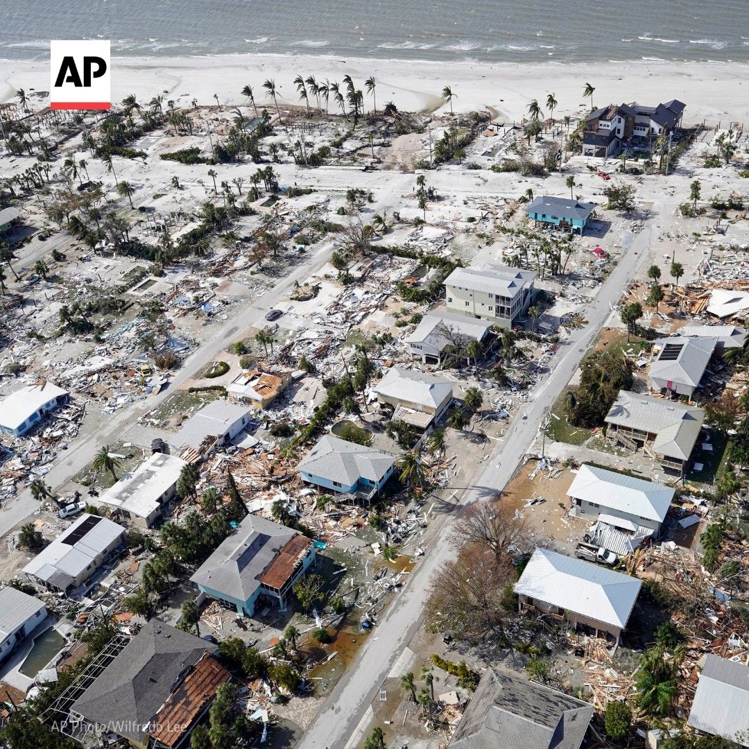
Here's the Fort Myers Beach pier, before and after, followed by a short video of the close up of the damage there. Plenty of similar footage from Marco Island, Naples, Bonita Beach, Sanibel, Punta Gorda, Port Charlotte, etc. Heartbreaking and breathtaking at the power of nature at the same time.
So net net the flooding is localized but that is all you see on the news. However, wind hits everybody. Also most flooding just requires you to replace flooring and some sheetrock. Wind damage causes new roofs and structures.
Back in the day I did demo on a few wood houses
Its an eye-opener to realize how easy they come apart
Nails are nothing - just big tacks
Two guys with a sledge, a bar and sawsall can take a house down pretty easy
I'm not surprised wind can take homes down in severe fashion
I was in a wood home for Sandy and 80 mph winds for only 30 seconds and felt the place moving
A few more mph/seconds and something was going to give
One thing we won't debate is that I have practical experience in dealing with flooding and your training is mostly via a hobby. You are not taking into the effect of the dunes which actually have a huge impact.Sorry, but the first part is mostly wrong. Water is essentially "continuous" meaning it will equalize its height by flowing from the source of rising water (the ocean in this case of surge) to areas on land that are normally dry and connected areas like inlets, bays and intracoastal areas. If the water rises 10 feet across the board from what it normally is at, say, high tide, that water will flood anywhere on land that is less than 10 feet in height above that high tide line, so if your house is 11 feet above that level, you'll still be a foot above the rising water, but a house at 6 feet above that high tide level will have 4 feet of flooding in this scenario.
Just look at the animation below, which shows the difference between normal water levels in Naples and the modeled credible worst case water levels in Naples after 12 feet of surge, showing vast majorities of the area under at least some water (some places have a foot of water, while others have 5 feet or more). In the 10 foot surge scenario I discussed above, only places above 10 feet won't flood, which is why they always only evacuate low lying areas, below the predicted worst surge and not everyone else, since they're above the surge level. Of course, low/high tides affect these numbers as does the additive effect of 1-2 feet of rainfall.
With regard to inland areas, both wind and flooding from torrential rains are very impactful, as large areas can become inundated and flooded when there are these incredible 10-20" rainfall amounts in a short time. You are correct, however, that wind can impact everyone and cause all kinds of damage - and lead to significant water damage from falling rain if a roof is damaged or windows broken (but that's really due to wind). One other complicating factor from an insurance perspective is that storm surge from a tropical storm is typically not covered by flood insurance - only surge flooding from hurricanes is, which is why it was such a big deal that Sandy was classified as extratropical (and not a hurricane) at landfall, meaning many people had difficulty getting coverage for surge flooding (iirc, this was later corrected for most, as some friends have told me, but in some cases it took years).
Also, here's the USGS elevation map, which one can use to check the elevation of any point in the US. If one zooms in on these coastal areas of SW FL, it's clear that large areas are at less than 10 feet of elevation, which is why the 10-15' storm surges observed for many areas produced such catastrophic flooding.
https://en-us.topographic-map.com/maps/c3a/Fort-Myers/
Here is the problem with your thinking with respect to the Ocean side. Assume a waves comes in and goes over the 8 foot dune. That is an 8+ foot surge as reported. The wave goes out and any of the water that makes it to the other side of the dune dissipates looking for the lowest point. If the dunes are 7.5 feet and the wave is 8 feet then the surge is an 8 foot surge with an effective 6 inches of the surge impacting homes. Only 6 inches makes it over the dune. The next wave comes in and again breaches the dune for another 8+ foot surge as reported with little water impacting the residential areas.. The water on the other side that has made it over the dune again dissipates to the lowest point.
With respect to your comment about water being essentially continuous, I agree it is in a lab because if water was continuous, there would be no currents but I'll skip that point.
I live on a barrier island that is about 1 mile wide. To have a wave that breaches an 8 foot dune might only require the ocean levels to be 3-4 feet or so above normal backed by tremendous winds. You do realize that the water rises as waves come in don't you. The ocean level is going up and down many many feet with each wave. Therefore if the ocean is 3 feet or so above normal the intracoastal is likely only 3 feet or so above normal (depending on how the winds and tide effect the water flow as we see with current) even though the ocean is generating 8 foot storm surges. That is why people living near the ocean at elevations much lower than ocean storm surges never get flooded.
Stop believing simplistic animations. Next hurricane I'll have the spare bedroom ready for you so you can get real life experience. Thanks for what you do.
You're mostly wrong on this too. If you're simply talking about localized waves hitting dunes that's very different from a surge (which is not the waves - it's the baseline ocean level going up) where the water on the ocean and bay side, which are generally continuous for barrier islands, rises 10 feet, for example, everywhere on that barrier island below 10 feet above normally dry ground will be inundated from a little to up to 10 feet. Period. Of course I'm being a bit simplistic, since to go into all of the gory details would require a lot more time, math and physics and my training in those is not a "hobby" - pretty sure I know those fundamental sciences far better than almost anyone, especially on a message board. And it's not just an animation - have you seen the footage of live flooding and subsequent damage of the barrier islands that were totally inundated? They certainly look a lot like that animation to me (and of course, that animation is likely not granular enough to be "perfect" but it conveys the point).One thing we won't debate is that I have practical experience in dealing with flooding and your training is mostly via a hobby. You are not taking into the effect of the dunes which actually have a huge impact.
Here is the problem with your thinking with respect to the Ocean side. Assume a waves comes in and goes over the 8 foot dune. That is an 8+ foot surge as reported. The wave goes out and any of the water that makes it to the other side of the dune dissipates looking for the lowest point. If the dunes are 7.5 feet and the wave is 8 feet then the surge is an 8 foot surge with an effective 6 inches of the surge impacting homes. Only 6 inches makes it over the dune. The next wave comes in and again breaches the dune for another 8+ foot surge as reported with little water impacting the residential areas.. The water on the other side that has made it over the dune again dissipates to the lowest point.
With respect to your comment about water being essentially continuous, I agree it is in a lab because if water was continuous, there would be no currents but I'll skip that point.
I live on a barrier island that is about 1 mile wide. To have a wave that breaches an 8 foot dune might only require the ocean levels to be 3-4 feet or so above normal backed by tremendous winds. You do realize that the water rises as waves come in don't you. The ocean level is going up and down many many feet with each wave. Therefore if the ocean is 3 feet or so above normal the intracoastal is likely only 3 feet or so above normal (depending on how the winds and tide effect the water flow as we see with current) even though the ocean is generating 8 foot storm surges. That is why people living near the ocean at elevations much lower than ocean storm surges never get flooded.
Stop believing simplistic animations. Next hurricane I'll have the spare bedroom ready for you so you can get real life experience. Thanks for what you do.
Last edited:
That same standard homeowners policy does NOT cover the peril of flood. A separate flood policy needs to be purchased.
I’m fine with insurance companies taking care of wind damage but the flood insurance is being taken care by the Federal government.
Do people in Florida need three policies - homeowners, flood and wind?
Similar threads
- Replies
- 553
- Views
- 33K
- Replies
- 369
- Views
- 17K
- Replies
- 13
- Views
- 770
ADVERTISEMENT
ADVERTISEMENT