
Colleges
- American Athletic
- Atlantic Coast
- Big 12
- Big East
- Big Ten
- Colonial
- Conference USA
- Independents (FBS)
- Junior College
- Mountain West
- Northeast
- Pac-12
- Patriot League
- Pioneer League
- Southeastern
- Sun Belt
- Army
- Charlotte
- East Carolina
- Florida Atlantic
- Memphis
- Navy
- North Texas
- Rice
- South Florida
- Temple
- Tulane
- Tulsa
- UAB
- UTSA
- Boston College
- California
- Clemson
- Duke
- Florida State
- Georgia Tech
- Louisville
- Miami (FL)
- North Carolina
- North Carolina State
- Pittsburgh
- Southern Methodist
- Stanford
- Syracuse
- Virginia
- Virginia Tech
- Wake Forest
- Arizona
- Arizona State
- Baylor
- Brigham Young
- Cincinnati
- Colorado
- Houston
- Iowa State
- Kansas
- Kansas State
- Oklahoma State
- TCU
- Texas Tech
- UCF
- Utah
- West Virginia
- Illinois
- Indiana
- Iowa
- Maryland
- Michigan
- Michigan State
- Minnesota
- Nebraska
- Northwestern
- Ohio State
- Oregon
- Penn State
- Purdue
- Rutgers
- UCLA
- USC
- Washington
- Wisconsin
High Schools
- Illinois HS Sports
- Indiana HS Sports
- Iowa HS Sports
- Kansas HS Sports
- Michigan HS Sports
- Minnesota HS Sports
- Missouri HS Sports
- Nebraska HS Sports
- Oklahoma HS Sports
- Texas HS Hoops
- Texas HS Sports
- Wisconsin HS Sports
- Cincinnati HS Sports
- Delaware
- Maryland HS Sports
- New Jersey HS Hoops
- New Jersey HS Sports
- NYC HS Hoops
- Ohio HS Sports
- Pennsylvania HS Sports
- Virginia HS Sports
- West Virginia HS Sports
ADVERTISEMENT
OT: Hurricane Ian to Bring Major to Catastrophic Impacts to Cuba/Florida (and 2022 Tropical Weather Thread):
- Thread starter RU848789
- Start date
I started a separate thread for soon-to-be-Hermine.


On vacation with family so pretty busy and didn't see it. I think we can live with 2 threads, but not my call...been talking about this threat since Tuesday night.I started a separate thread for soon-to-be-Hermine.
The convection is still displaced west of the center of circulation, so it might not be named a TS until tonight, which might allow TD-10 just off the African coast to be named first, which that the Caribbean storm might be named Ian.
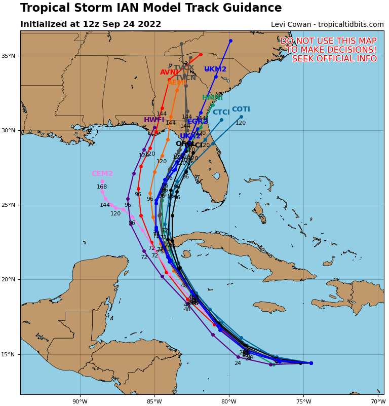
People also need to realize that we're still 5+ days from any possible FL landfall, and the model spread (even within a single model's ensemble runs, using some variation across initial conditions to illustrate model uncertainty and sensitivity to small changes in these inputs) shows potential landfalls from Pensacola to the western Bahamas.
But with very likely low shear and high oceanic heat content along its forecast track (and tracking over a relatively flat western Cuba) this is a potentially explosive storm, especially as it nears Cuba and then Florida. Dr. Knabb, former NHC director, just said all this on TWC, which has really become an excellent source on tropical systems over the last several years.
That will likely shift over the coming days.
TD-10 near the Cape Verde Islands just became Hermine, while TD-9 remains a tropical depression, so TD-9 in the Caribbean will very likely become Ian in the next 6-12 hours. Regardless, the 5 pm advisory, which just came out, has likely-Ian now becoming a major, Cat 3 hurricane at landfall in SW FL on Weds am. As I said above, though, the cone of uncertainty on track is quite large and intensity forecasts are even less accurate than track forecasts, so we have a long way to go to see where, when, and how strong the storm is at landfall.
https://www.nhc.noaa.gov/graphics_at4.shtml?start#contents
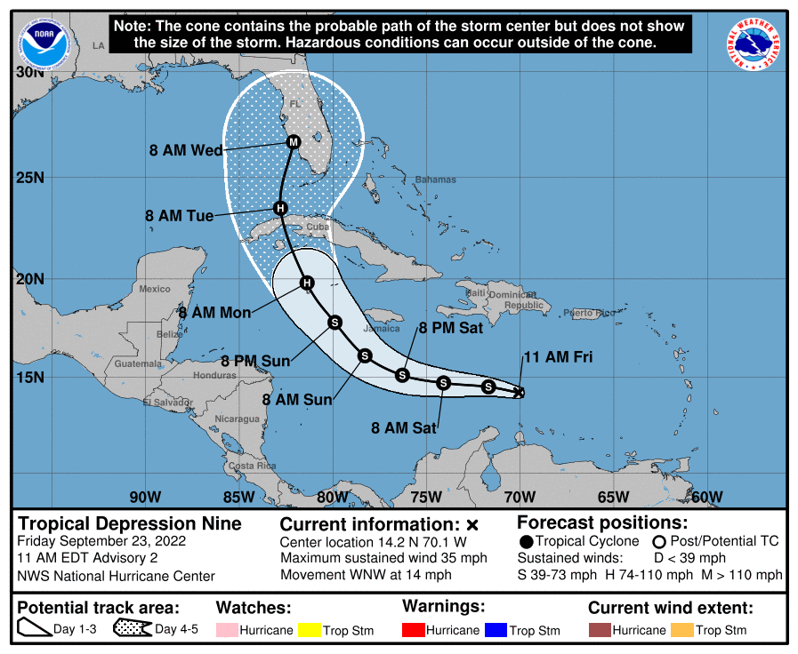
https://www.nhc.noaa.gov/graphics_at4.shtml?start#contents
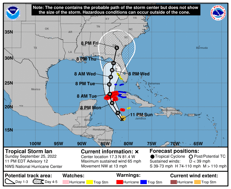
We finally have Tropical Storm Ian (40 mph winds) as of 11 pm. No major changes to the forecast track or intensity, with Ian still forecast to go over western Cuba and then to make landfall in SW Florida as a Cat 3 hurricane, although again, nearly 5 days out the uncertainty on track and intensity are quite high, so interests from the FL panhandle to Miami still need to be watching this closely.
https://www.nhc.noaa.gov/graphics_at4.shtml?start#contents
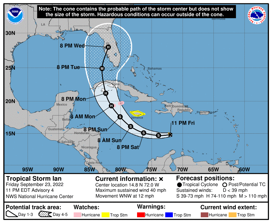
FORECAST POSITIONS AND MAX WINDS
INIT 24/0300Z 14.8N 72.0W 35 KT 40 MPH
12H 24/1200Z 14.7N 73.9W 40 KT 45 MPH
24H 25/0000Z 15.1N 76.3W 45 KT 50 MPH
36H 25/1200Z 16.1N 78.4W 50 KT 60 MPH
48H 26/0000Z 17.6N 80.1W 60 KT 70 MPH
60H 26/1200Z 19.3N 81.5W 75 KT 85 MPH...NEAR GRAND CAYMAN
72H 27/0000Z 21.2N 82.4W 90 KT 105 MPH
96H 28/0000Z 24.9N 83.0W 100 KT 115 MPH
120H 29/0000Z 28.0N 82.0W 95 KT 110 MPH...OVER FLORIDA
And Fiona is just a few hours away from landfall in eastern Nova Scotia with winds expected to be near 100 mph at landfall (currently 105 mph), which is almost unheard of for Canada. Fiona is going to do significant damage from winds, surge and rain.
https://www.nhc.noaa.gov/text/refresh/MIATCPAT2+shtml/240253.shtml?
https://www.nhc.noaa.gov/graphics_at4.shtml?start#contents
FORECAST POSITIONS AND MAX WINDS
INIT 24/0300Z 14.8N 72.0W 35 KT 40 MPH
12H 24/1200Z 14.7N 73.9W 40 KT 45 MPH
24H 25/0000Z 15.1N 76.3W 45 KT 50 MPH
36H 25/1200Z 16.1N 78.4W 50 KT 60 MPH
48H 26/0000Z 17.6N 80.1W 60 KT 70 MPH
60H 26/1200Z 19.3N 81.5W 75 KT 85 MPH...NEAR GRAND CAYMAN
72H 27/0000Z 21.2N 82.4W 90 KT 105 MPH
96H 28/0000Z 24.9N 83.0W 100 KT 115 MPH
120H 29/0000Z 28.0N 82.0W 95 KT 110 MPH...OVER FLORIDA
And Fiona is just a few hours away from landfall in eastern Nova Scotia with winds expected to be near 100 mph at landfall (currently 105 mph), which is almost unheard of for Canada. Fiona is going to do significant damage from winds, surge and rain.
https://www.nhc.noaa.gov/text/refresh/MIATCPAT2+shtml/240253.shtml?
Last edited:
A hurricane? On Oak Island??!!
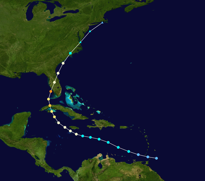
Eerily similar (Charley's track is the first graphic below) and would've been even more similar if Ian had formed 2 days ago, as its track across the Leeward Islands into the Caribbean was also very close to Charley's. And any storm heading mostly northward near/along Florida means tiny track errors can have huge downstream track changes.The track forecast is so similar to Charley. With the shape of the Florida coast, slight path changes make a huge difference in where the eye crosses the coast.
Looks like the one off the west coast of Africa must have been juicing as it beefed up faster than the now named Ian.
Probably ate a lot of lo-bro.
Current growth of TS Ian is still being inhibited by north-northwesterly shear, however the center of low pressure is now located beneath the eastern edge of convection, cloud tops on the western side of the storm have gotten colder and the shear is expected to ease over the next day or so.
There is still a very broad spread in the models relative to Ian's track. The NHC guidance, below, is as always the current best estimate but is subject to change five days from U.S. landfall. What is expected is that Ian will undergo a period of Rapid Intensification and ultimately make landfall as a major hurricane of Category 3 or higher.
At this time, pretty much everyone on the Florida Gulf Coast should closely monitor Ian's progress and make initial preparations for landfall.
Well said. Minor correction: it's been experiencing northeasterly shear and that shear is just about over, so between that and the abnormally warm waters in the Caribbean and GOM, everything is primed for rapid intensification. Cat 4 is not out of the question at landfall somewhere on the FL west coast (the NHC track is on the eastern edge of the model consensus, so a nudge west in the forecast track might be seen at 11 am). .Current growth of TS Ian is still being inhibited by north-northwesterly shear, however the center of low pressure is now located beneath the eastern edge of convection, cloud tops on the western side of the storm have gotten colder and the shear is expected to ease over the next day or so.
There is still a very broad spread in the models relative to Ian's track. The NHC guidance, below, is as always the current best estimate but is subject to change five days from U.S. landfall. What is expected is that Ian will undergo a period of Rapid Intensification and ultimately make landfall as a major hurricane of Category 3 or higher.
At this time, pretty much everyone on the Florida Gulf Coast should closely monitor Ian's progress and make initial preparations for landfall.
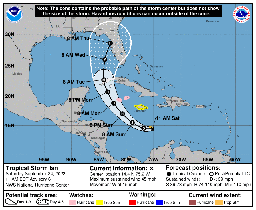
We finally have Tropical Storm Ian (40 mph winds) as of 11 pm. No major changes to the forecast track or intensity, with Ian still forecast to go over western Cuba and then to make landfall in SW Florida as a Cat 3 hurricane, although again, nearly 5 days out the uncertainty on track and intensity are quite high, so interests from the FL panhandle to Miami still need to be watching this closely.
https://www.nhc.noaa.gov/graphics_at4.shtml?start#contents
FORECAST POSITIONS AND MAX WINDS
INIT 24/0300Z 14.8N 72.0W 35 KT 40 MPH
12H 24/1200Z 14.7N 73.9W 40 KT 45 MPH
24H 25/0000Z 15.1N 76.3W 45 KT 50 MPH
36H 25/1200Z 16.1N 78.4W 50 KT 60 MPH
48H 26/0000Z 17.6N 80.1W 60 KT 70 MPH
60H 26/1200Z 19.3N 81.5W 75 KT 85 MPH...NEAR GRAND CAYMAN
72H 27/0000Z 21.2N 82.4W 90 KT 105 MPH
96H 28/0000Z 24.9N 83.0W 100 KT 115 MPH
120H 29/0000Z 28.0N 82.0W 95 KT 110 MPH...OVER FLORIDA
And Fiona is just a few hours away from landfall in eastern Nova Scotia with winds expected to be near 100 mph at landfall (currently 105 mph), which is almost unheard of for Canada. Fiona is going to do significant damage from winds, surge and rain.
https://www.nhc.noaa.gov/text/refresh/MIATCPAT2+shtml/240253.shtml?
The NE-ly shear Ian has been experiencing for the past few days is just about over, so between that and the abnormally warm waters in the Caribbean and GOM, which Ian will be traversing, everything is primed for rapid intensification. Cat 4 is not out of the question at landfall somewhere on the FL west coast, despite the forecast Cat 3 strength of 115 mph (intensity forecasts are generally more inaccurate than track forecasts). Currently, Ian is still at 45 mph, but the storm is starting to become much better organized with regard to convection, circulation and outflow. Also, the NHC forecast track is on the eastern edge of the model consensus, so a nudge west in the forecast track was made with the 11 am package, with estimated landfall just north of Tampa, now.
https://www.nhc.noaa.gov/
FORECAST POSITIONS AND MAX WINDS
INIT 24/1500Z 14.4N 75.2W 40 KT 45 MPH
12H 25/0000Z 14.5N 76.8W 45 KT 50 MPH
24H 25/1200Z 15.5N 78.9W 55 KT 65 MPH
36H 26/0000Z 17.0N 80.7W 70 KT 80 MPH
48H 26/1200Z 18.8N 82.3W 85 KT 100 MPH
60H 27/0000Z 20.7N 83.4W 95 KT 110 MPH
72H 27/1200Z 22.7N 84.1W 100 KT 115 MPH
96H 28/1200Z 26.0N 83.9W 105 KT 120 MPH
120H 29/1200Z 28.6N 82.9W 95 KT 110 MPH
Fiona made landfall several hours ago with 90 mph winds on the eastern end of Nova Scotia. Damage is extensive there and on Prince Edward Island with most people out of power - many are saying this is the worst storm to hit there in a long, long time - see the link below for reports on the damage and impacts.
https://www.cnn.com/americas/live-news/fiona-storm-path-nova-scotia/index.html
Yes, the 11 am forecast did nudge the track west a bit with landfall now forecast to be a bit north of Tampa at about 120 mph (high uncertainty still)...Well said. Minor correction: it's been experiencing northeasterly shear and that shear is just about over, so between that and the abnormally warm waters in the Caribbean and GOM, everything is primed for rapid intensification. Cat 4 is not out of the question at landfall somewhere on the FL west coast (the NHC track is on the eastern edge of the model consensus, so a nudge west in the forecast track might be seen at 11 am). .
Possibly, in a week or so, but too far out to predict with much accuracy...What’s the long term. Will remnants come up this way?
Possibly, in a week or so, but too far out to predict with much accuracy...
Charlie is a good analog, but I was chatting with Gary S. yesterday and whether it plays out is questionable as per high pressure progged over upper NY / NE. We should have a better idea in a couple of days.
Also worth pointing out (just cuz it's interesting) that the decreased landfall intensity forecasted with the left-shift in track is likely due to prolonged interaction of Q1 / Q2 with the Florida coast.
This thing's gonna oscillate for another 48 hours before the track really settles in. Still, I'd probably gas up the gennie if I was in the Tampa St. Pete area.
I have to drive home (Jersey City to Columbia, SC) next weekend. It looks like I may either need to leave earlier than planned or take an extra day off. Extra day off meets with my approval.
The NW Caribbean is where many monsters have taken off like Gilbert and Wilma. Everyone on the Gulf Coast of Florida needs to be prepared to evacuate if the track settles on their area.
The NW Caribbean is where many monsters have taken off like Gilbert and Wilma. Everyone on the Gulf Coast of Florida needs to be prepared to evacuate if the track settles on their area.
Yeah, the 12Z model spread on track past about FL is fairly large, as per below, so hard to say much about where it goes after that. I do think it's a decent guess that Ian will head across FL and be lifted back out to sea by the strong trough coming through the eastern US on Weds/Thursday, but that's a bit of a guess.Charlie is a good analog, but I was chatting with Gary S. yesterday and whether it plays out is questionable as per high pressure progged over upper NY / NE. We should have a better idea in a couple of days.
Also worth pointing out (just cuz it's interesting) that the decreased landfall intensity forecasted with the left-shift in track is likely due to prolonged interaction of Q1 / Q2 with the Florida coast.
This thing's gonna oscillate for another 48 hours before the track really settles in. Still, I'd probably gas up the gennie if I was in the Tampa St. Pete area.
Good point on the prolonged interaction with land possibly weakening Ian before landfall, although we've sometimes seen that overpredicted, probably given how low/flat FL is. And as many have noted, with the angle of approach, a 10-20 mile track shift west or east now or in the next day or so could easily be the difference in a landfall on the panhandle vs. one in Naples.
A hurricane? On Oak Island??!!
Maybe the winds finally uncover all the hidden gold?
Well, they don't call it The Big Bend for nothin'. 11PM guidance shifts north, once again, and aims Ian at the astonishingly unpopulated area between Fish Creek and Alligator Point.
If you've never been to the Big Bend region, I highly recommend it. A number of Wildlife Management Areas and Aquatic Preserves with almost nobody living in this coastal region that stretches for about 100 miles from Cedar Key up to Apalachee Bay.

If you've never been to the Big Bend region, I highly recommend it. A number of Wildlife Management Areas and Aquatic Preserves with almost nobody living in this coastal region that stretches for about 100 miles from Cedar Key up to Apalachee Bay.
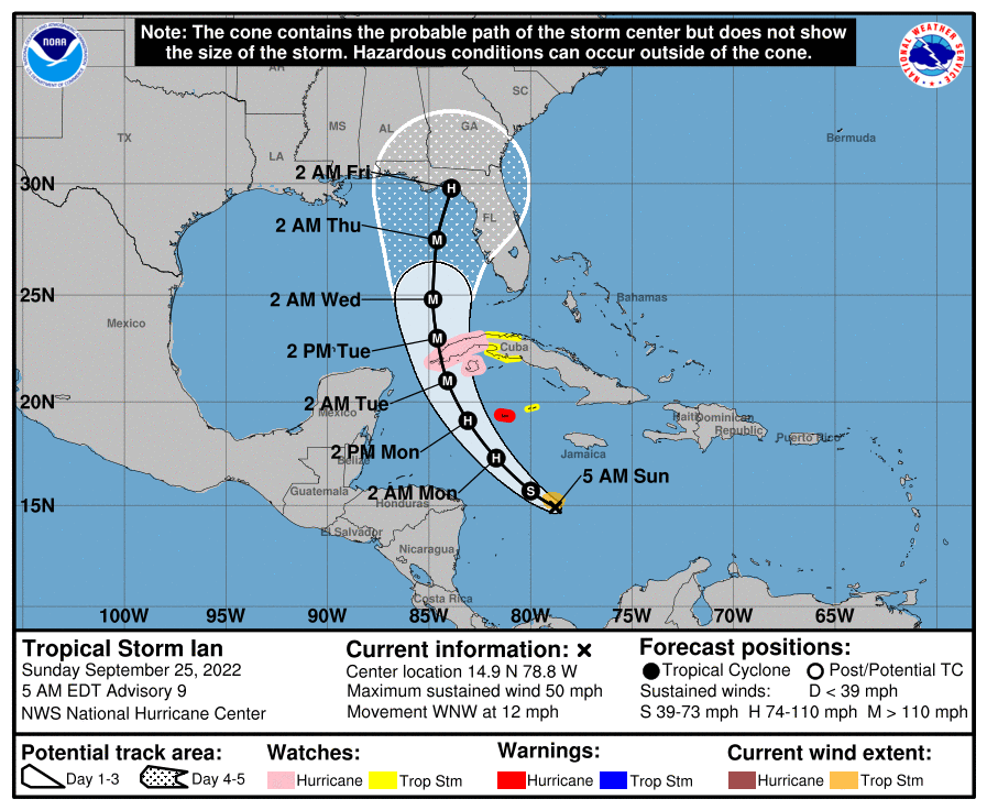
The 5 am advisory (1st graphic below and the table of positions of the storm below that) maintains the westward shift of Ian, with landfall still forecast for the Big Bend area, which is fortunate for two reasons: as you said, it's sparsely populated, limiting damage/impact, but perhaps more importantly, the forecast is calling for significant weakening of the storm from off the coast of Florida, due to increased shear, where Ian is forecast to have ~140 mph winds (Cat 4) well west of the Keys, decreasing to ~120 mph off the coast of Tampa to just ~90 mph at landfall. Having said that, as per below, folks from Tampa to Pensacola still need to watching this closely, as the model spread on track is quite high, as per the 2nd graphic below - and if landfall were to occur closer to Tampa, winds would likely to still be in the 120 mph range.Well, they don't call it The Big Bend for nothin'. 11PM guidance shifts north, once again, and aims Ian at the astonishingly unpopulated area between Fish Creek and Alligator Point.
If you've never been to the Big Bend region, I highly recommend it. A number of Wildlife Management Areas and Aquatic Preserves with almost nobody living in this coastal region that stretches for about 100 miles from Cedar Key up to Apalachee Bay.
Ian currently is at 50 mph, but is starting to get more organized (the surface and mid-level centers of circulation are still not aligned though) and poised to start rapid intensification over the next 2 days, as it's expected to go from 50 mph now to ~120 mph in 2 days as it strikes the far western tip of Cuba. I will say that's a very hopeful forecast, but if I lived near the landfall area, I wouldn't want to bank on that much weakening, which is unusual, as large hurricanes sometimes "make their own weather" so to speak and aren't impacted as much as expected by shear. Let's hope the forecast is correct on the weakening (and maybe not as much strengthening as forecast).
With regard to the greater than usual uncertainty in the storm's forecast track, as well as the predicted weakening as the storm approaches the panhandle (if it takes that track), the nuggets, below, from the NHC explain their thinking well; the 2nd link, from TWC does a nice job of providing a comprehensive storm overview. But there's much that can go wrong with this forecast, as per the NHC discussion.
With respect to our area, it's still too early to have confidence in any forecast, given the range of possibilities for landfall a couple of days prior to any impacts in our area. However, impacts are quite possible either from remnants of the storm (if it stays inland - meaning likely possible heavy rains from a tropical depression or just a remnant low) or from the storm if it crosses over FL into the Atlantic and weakens, but remains a TS/hurricane and heads up the coast, possibly near us - best case for us would be if it emerged into the Atlantic and went out to sea.
https://www.nhc.noaa.gov/text/refresh/MIATCDAT4+shtml/241454.shtml?
https://weather.com/safety/hurricane/news/2022-09-25-tropical-storm-hurricane-ian-florida-cuba
Even with the addition of the NOAA G-IV synoptic
surveillance dropsonde data and additional upper-air balloon
releases across much of the United States, the spread in the
guidance has not narrowed from before. The UKMET and ECMWF models
continue to hold firm along the eastern side of the guidance and
show a track into west-central Florida, while the GFS and HWRF
remain one the western side, taking the Ian into the central or
western Florida panhandle. The updated NHC track continues to
split these differences and remains closest to the TVCA multi-model
consensus, and the latest GFS ensemble mean. The new track is very
similar to the previous advisory. With the cross-track spreading
remaining between 200-220 n mi at days 4 and 5, it cannot be
overstated that significant uncertainty remains in Ian's long-range
prediction.
After that time, a significant increase in southwesterly shear is
predicted by the global models, and weakening is forecast to occur
while Ian approaches the Florida coast. Despite the reduction in
intensity, Ian is likely to have an expanding wind field and will be
slowing down by that time, which will have the potential to produce
significant wind and storm surge impacts.
FORECAST POSITIONS AND MAX WINDS
INIT 25/0900Z 14.9N 78.8W 45 KT 50 MPH
12H 25/1800Z 15.7N 80.0W 55 KT 65 MPH
24H 26/0600Z 17.3N 81.7W 70 KT 80 MPH
36H 26/1800Z 19.1N 83.1W 90 KT 105 MPH
48H 27/0600Z 21.0N 84.1W 105 KT 120 MPH
60H 27/1800Z 23.0N 84.6W 115 KT 130 MPH
72H 28/0600Z 24.8N 84.8W 120 KT 140 MPH
96H 29/0600Z 27.5N 84.6W 105 KT 120 MPH
120H 30/0600Z 29.8N 83.9W 80 KT 90 MPH
Good stories on the impacts of Fiona on Atlantic Canada, from Nova Scotia to Prince Edward Island and Labrador/Newfoundland in the links below. Devastating surge, flooding from rains and wind damage were seen across the area, including loss of power to most residents in these areas - they're already calling Fiona "Canada's Sandy." Meteorologically, Fiona shattered the all-time Canadian low pressure record with 931 mbar recorded in Nova Scotia (previous record was 940 mbar). And even if the system wasn't technically a hurricane at landfall, as it had transitioned to a post-tropical storm (primarily cold core), it certainly had Cat 2 winds at landfall of 90-100 mph - the highest gust recorded was 111 mph in NS.
https://www.nytimes.com/article/tropical-storm-fiona-hurricane.html
https://www.cnn.com/2022/09/24/weather/hurricane-fiona-canada-saturday/index.html
https://www.nytimes.com/article/tropical-storm-fiona-hurricane.html
https://www.cnn.com/2022/09/24/weather/hurricane-fiona-canada-saturday/index.html
I can't wait to see how Electric cars handle the hurricane evacuations. Clogged roadways filled with dead batteries. The gift that keeps on giving from your Liberal fear mongers.
Last edited:
Hmm, very interesting point!I can't wait to see how Electric cars handle the hurricane evacuations. Clogged roadways filled with dead batteries. The gift that keeps on giving from your Liberal fear mongers.
ne
The 5 am advisory (1st graphic below and the table of positions of the storm below that) maintains the westward shift of Ian, with landfall still forecast for the Big Bend area, which is fortunate for two reasons: as you said, it's sparsely populated, limiting damage/impact, but perhaps more importantly, the forecast is calling for significant weakening of the storm from off the coast of Florida, due to increased shear, where Ian is forecast to have ~140 mph winds (Cat 4) well west of the Keys, decreasing to ~120 mph off the coast of Tampa to just ~90 mph at landfall. Having said that, as per below, folks from Tampa to Pensacola still need to watching this closely, as the model spread on track is quite high, as per the 2nd graphic below - and if landfall were to occur closer to Tampa, winds would likely to still be in the 120 mph range.
Ian currently is at 50 mph, but is starting to get more organized (the surface and mid-level centers of circulation are still not aligned though) and poised to start rapid intensification over the next 2 days, as it's expected to go from 50 mph now to ~120 mph in 2 days as it strikes the far western tip of Cuba. I will say that's a very hopeful forecast, but if I lived near the landfall area, I wouldn't want to bank on that much weakening, which is unusual, as large hurricanes sometimes "make their own weather" so to speak and aren't impacted as much as expected by shear. Let's hope the forecast is correct on the weakening (and maybe not as much strengthening as forecast).
With regard to the greater than usual uncertainty in the storm's forecast track, as well as the predicted weakening as the storm approaches the panhandle (if it takes that track), the nuggets, below, from the NHC explain their thinking well; the 2nd link, from TWC does a nice job of providing a comprehensive storm overview. But there's much that can go wrong with this forecast, as per the NHC discussion.
With respect to our area, it's still too early to have confidence in any forecast, given the range of possibilities for landfall a couple of days prior to any impacts in our area. However, impacts are quite possible either from remnants of the storm (if it stays inland - meaning likely possible heavy rains from a tropical depression or just a remnant low) or from the storm if it crosses over FL into the Atlantic and weakens, but remains a TS/hurricane and heads up the coast, possibly near us - best case for us would be if it emerged into the Atlantic and went out to sea.
https://www.nhc.noaa.gov/text/refresh/MIATCDAT4+shtml/241454.shtml?
https://weather.com/safety/hurricane/news/2022-09-25-tropical-storm-hurricane-ian-florida-cuba
Even with the addition of the NOAA G-IV synoptic
surveillance dropsonde data and additional upper-air balloon
releases across much of the United States, the spread in the
guidance has not narrowed from before. The UKMET and ECMWF models
continue to hold firm along the eastern side of the guidance and
show a track into west-central Florida, while the GFS and HWRF
remain one the western side, taking the Ian into the central or
western Florida panhandle. The updated NHC track continues to
split these differences and remains closest to the TVCA multi-model
consensus, and the latest GFS ensemble mean. The new track is very
similar to the previous advisory. With the cross-track spreading
remaining between 200-220 n mi at days 4 and 5, it cannot be
overstated that significant uncertainty remains in Ian's long-range
prediction.
After that time, a significant increase in southwesterly shear is
predicted by the global models, and weakening is forecast to occur
while Ian approaches the Florida coast. Despite the reduction in
intensity, Ian is likely to have an expanding wind field and will be
slowing down by that time, which will have the potential to produce
significant wind and storm surge impacts.
FORECAST POSITIONS AND MAX WINDS
INIT 25/0900Z 14.9N 78.8W 45 KT 50 MPH
12H 25/1800Z 15.7N 80.0W 55 KT 65 MPH
24H 26/0600Z 17.3N 81.7W 70 KT 80 MPH
36H 26/1800Z 19.1N 83.1W 90 KT 105 MPH
48H 27/0600Z 21.0N 84.1W 105 KT 120 MPH
60H 27/1800Z 23.0N 84.6W 115 KT 130 MPH
72H 28/0600Z 24.8N 84.8W 120 KT 140 MPH
96H 29/0600Z 27.5N 84.6W 105 KT 120 MPH
120H 30/0600Z 29.8N 83.9W 80 KT 90 MPH
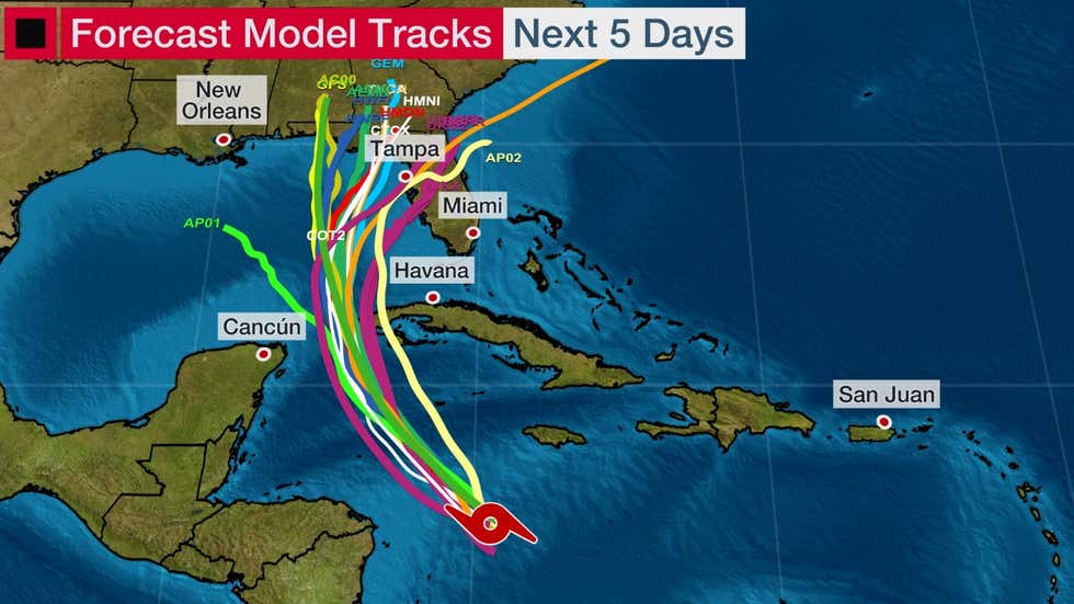
Not much change in Ian over the past 12 hours, with the storm not consolidating and strengthening - winds not having increased at all vs. the prediction of winds increasing from 45 to 65 mph over the last 12 hours. However, the NHC and every expert I've seen still expect the consolidation and rapid intensification tonight through tomorrow, such that Ian is still expected to be a major hurricane as it crosses western Cuba on Tuesday morning, as well as during its trip north just off the Florida coast, with landfall still a guess, i.e., being anywhere from Pensacola to south of Tampa by Thursday/Friday.
My guess is we won't see convergence of model solutions (Euro has landfall near Tampa, while the GFS has it near Pensacola with most others between those) until Ian gets better organized/stronger and starts moving more quickly to the north, which will provide more accurate initial conditions for future model runs. Until then, everyone on the FL coast needs to watch this closely. One other point: even if Ian hits the Big Bend or the panhandle without striking the western Gulf coast, that doesn't mean there won't be major impacts from Tampa northward (and even down to Naples), as a major hurricane 50-100 miles offshore will still bring torrential rains and significant storm surge, plus at at least strong TS force winds. Still too early to predict impacts north of FL and especially in our area.
https://www.nhc.noaa.gov/graphics_at4.shtml?start#contents
FORECAST POSITIONS AND MAX WINDS
INIT 25/2100Z 16.2N 80.3W 40 KT 45 MPH
12H 26/0600Z 17.3N 81.5W 50 KT 60 MPH
24H 26/1800Z 19.2N 82.9W 70 KT 80 MPH
36H 27/0600Z 21.1N 83.7W 90 KT 105 MPH
48H 27/1800Z 23.0N 84.2W 105 KT 120 MPH
60H 28/0600Z 24.8N 84.4W 115 KT 130 MPH
72H 28/1800Z 26.2N 84.4W 110 KT 125 MPH
96H 29/1800Z 28.3N 84.0W 85 KT 100 MPH
120H 30/1800Z 31.0N 83.0W 50 KT 60 MPH...INLAND
Well, the oft-promised rapid intensification looks like it's finally underway, as Ian is starting to look very impressive with deep convection blowing up around the storm's center, which is more organized than it's been, to date, and winds picking up from 45 mph at 5 pm to 65 pm at 11 pm. And winds are forecast to increase to 115 mph by Tuesday morning as the storm passes over western Cuba and to 130 mph as the storm approaches the FL Gulf coast, although some weakening is forecast after that, as the storm makes landfall somewhere from Tampa to the Big Bend.Not much change in Ian over the past 12 hours, with the storm not consolidating and strengthening - winds not having increased at all vs. the prediction of winds increasing from 45 to 65 mph over the last 12 hours. However, the NHC and every expert I've seen still expect the consolidation and rapid intensification tonight through tomorrow, such that Ian is still expected to be a major hurricane as it crosses western Cuba on Tuesday morning, as well as during its trip north just off the Florida coast, with landfall still a guess, i.e., being anywhere from Pensacola to south of Tampa by Thursday/Friday.
My guess is we won't see convergence of model solutions (Euro has landfall near Tampa, while the GFS has it near Pensacola with most others between those) until Ian gets better organized/stronger and starts moving more quickly to the north, which will provide more accurate initial conditions for future model runs. Until then, everyone on the FL coast needs to watch this closely. One other point: even if Ian hits the Big Bend or the panhandle without striking the western Gulf coast, that doesn't mean there won't be major impacts from Tampa northward (and even down to Naples), as a major hurricane 50-100 miles offshore will still bring torrential rains and significant storm surge, plus at at least strong TS force winds. Still too early to predict impacts north of FL and especially in our area.
https://www.nhc.noaa.gov/graphics_at4.shtml?start#contents
FORECAST POSITIONS AND MAX WINDS
INIT 25/2100Z 16.2N 80.3W 40 KT 45 MPH
12H 26/0600Z 17.3N 81.5W 50 KT 60 MPH
24H 26/1800Z 19.2N 82.9W 70 KT 80 MPH
36H 27/0600Z 21.1N 83.7W 90 KT 105 MPH
48H 27/1800Z 23.0N 84.2W 105 KT 120 MPH
60H 28/0600Z 24.8N 84.4W 115 KT 130 MPH
72H 28/1800Z 26.2N 84.4W 110 KT 125 MPH
96H 29/1800Z 28.3N 84.0W 85 KT 100 MPH
120H 30/1800Z 31.0N 83.0W 50 KT 60 MPH...INLAND
The NHC track was shifted back east some, as the GFS moved the track east (landfall at the Big Bend) towards where the Euro has been, without wavering for awhile (Euro has landfall around Tampa). Having said that, everywhere from about Naples to Panama City still is in the cone of uncertainty for landfall and even if the storm stays offshore up the FL coast, impacts will be substantial (and perhaps catastrophic where the storm comes close enough or makes landfall) to coastal areas with regard to surge, winds, and flooding rains, especially if the storm slows down significantly, as some models are showing. It is starting to look like the remnants of the storm might impact our area next weekend, but still too early to forecast the exact impacts.
https://www.nhc.noaa.gov/graphics_at4.shtml?start#contents
FORECAST POSITIONS AND MAX WINDS
INIT 26/0300Z 17.3N 81.4W 55 KT 65 MPH
12H 26/1200Z 18.7N 82.3W 65 KT 75 MPH
24H 27/0000Z 20.8N 83.5W 85 KT 100 MPH
36H 27/1200Z 22.7N 84.0W 100 KT 115 MPH
48H 28/0000Z 24.7N 84.1W 105 KT 120 MPH
60H 28/1200Z 26.2N 83.8W 115 KT 130 MPH
72H 29/0000Z 27.6N 83.5W 105 KT 120 MPH
96H 30/0000Z 29.0N 83.2W 80 KT 90 MPH
120H 01/0000Z 32.0N 82.5W 40 KT 45 MPH...INLAND
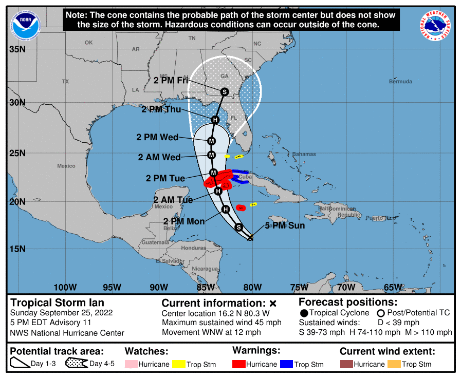
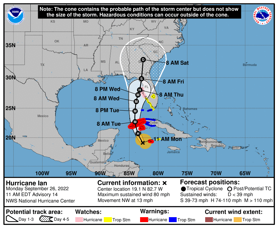
Ian became a hurricane as of the 5 am advisory and is up to 80 mph with the 11 am advisory, although it didn't strengthen quite as much as expected, as there is still some dry air working its way into the storm, but that is forecast to abate and when it does, more intensification will occur. Despite that, the NHC has upped the forecast strength of Ian once it exits the west coast of Cuba, with winds forecast to reach 140 mph (Cat 4) as it reaches the latitude of Key West (although it'll be 200 miles west of there at that time) through when it is at the latitude of Fort Myers (and it'll be close to the coast or even making landfall if the Euro/UK are correct, as they show landfall around Tampa Thursday morning, although the NHC track is still offshore a bit with landfall a bit north of there (but impacts would still be substantial to catastrophic with that track). The storm is forecast to weaken some to maybe 110 mph as it nears Tampa though and north of there. Still too early to predict impacts here, but some rain is looking likely by the weekend.
FORECAST POSITIONS AND MAX WINDS
INIT 26/1500Z 19.1N 82.7W 70 KT 80 MPH
12H 27/0000Z 20.7N 83.5W 90 KT 105 MPH
24H 27/1200Z 22.7N 84.0W 105 KT 120 MPH
36H 28/0000Z 24.5N 84.0W 120 KT 140 MPH
48H 28/1200Z 26.1N 83.8W 120 KT 140 MPH
60H 29/0000Z 27.2N 83.5W 105 KT 120 MPH
72H 29/1200Z 28.0N 83.2W 90 KT 105 MPH
96H 30/1200Z 29.8N 82.9W 55 KT 65 MPH...INLAND
120H 01/1200Z 32.8N 82.6W 30 KT 35 MPH...INLAND
Similar threads
- Replies
- 553
- Views
- 34K
- Replies
- 412
- Views
- 22K
- Replies
- 13
- Views
- 805
ADVERTISEMENT
ADVERTISEMENT