You've never seen cars that ran out of gas on the highways during evacuations?I can't wait to see how Electric cars handle the hurricane evacuations. Clogged roadways filled with dead batteries. The gift that keeps on giving from your Liberal fear mongers.
Colleges
- American Athletic
- Atlantic Coast
- Big 12
- Big East
- Big Ten
- Colonial
- Conference USA
- Independents (FBS)
- Junior College
- Mountain West
- Northeast
- Pac-12
- Patriot League
- Pioneer League
- Southeastern
- Sun Belt
- Army
- Charlotte
- East Carolina
- Florida Atlantic
- Memphis
- Navy
- North Texas
- Rice
- South Florida
- Temple
- Tulane
- Tulsa
- UAB
- UTSA
- Boston College
- California
- Clemson
- Duke
- Florida State
- Georgia Tech
- Louisville
- Miami (FL)
- North Carolina
- North Carolina State
- Pittsburgh
- Southern Methodist
- Stanford
- Syracuse
- Virginia
- Virginia Tech
- Wake Forest
- Arizona
- Arizona State
- Baylor
- Brigham Young
- Cincinnati
- Colorado
- Houston
- Iowa State
- Kansas
- Kansas State
- Oklahoma State
- TCU
- Texas Tech
- UCF
- Utah
- West Virginia
- Illinois
- Indiana
- Iowa
- Maryland
- Michigan
- Michigan State
- Minnesota
- Nebraska
- Northwestern
- Ohio State
- Oregon
- Penn State
- Purdue
- Rutgers
- UCLA
- USC
- Washington
- Wisconsin
High Schools
- Illinois HS Sports
- Indiana HS Sports
- Iowa HS Sports
- Kansas HS Sports
- Michigan HS Sports
- Minnesota HS Sports
- Missouri HS Sports
- Nebraska HS Sports
- Oklahoma HS Sports
- Texas HS Hoops
- Texas HS Sports
- Wisconsin HS Sports
- Cincinnati HS Sports
- Delaware
- Maryland HS Sports
- New Jersey HS Hoops
- New Jersey HS Sports
- NYC HS Hoops
- Ohio HS Sports
- Pennsylvania HS Sports
- Virginia HS Sports
- West Virginia HS Sports
ADVERTISEMENT
You are using an out of date browser. It may not display this or other websites correctly.
You should upgrade or use an alternative browser.
You should upgrade or use an alternative browser.
OT: Hurricane Ian to Bring Major to Catastrophic Impacts to Cuba/Florida (and 2022 Tropical Weather Thread):
- Thread starter RU848789
- Start date
You've never seen cars that ran out of gas on the highways during evacuations?
Still, you can always bring gas to them and move em out
Youre gonna a need a very large gas powered generator to move all those cars again. Or a lot of tow trucks
#s / 4Real - I’m Assuming FSU game in Tallahasses is postponed on Saturday?
Need to change flights etc if so
Need to change flights etc if so
No idea, but given the forecast, no need to cancel at this time, as the storm should be well NE of Tallahassee by 8 am and the game is at 3:30 pm. However, I suspect they'll cancel out of caution in case the forecast changes (always possible).#s / 4Real - I’m Assuming FSU game in Tallahasses is postponed on Saturday?
Need to change flights etc if so
Still, you can always bring gas to them and move em out
Youre gonna a need a very large gas powered generator to move all those cars again. Or a lot of tow trucks
Or just a Ford F-150 Lightning.
Because they're a bunch of wusses! It's just a little rain and wind. This is football! A man's game! Where men are men and sheep are scared!No idea, but given the forecast, no need to cancel at this time, as the storm should be well NE of Tallahassee by 8 am and the game is at 3:30 pm. However, I suspect they'll cancel out of caution in case the forecast changes (always possible).
Cancel THIS, weather wusses! 🤪
If you live in Florida anywhere near the Gulf Coast from Apalachicola to Ft. Myers, and especially anywhere within 20-30 miles of Tampa/St. Pete, it's time to start thinking about rushing preparations to completion or perhaps evacuating.Ian became a hurricane as of the 5 am advisory and is up to 80 mph with the 11 am advisory, although it didn't strengthen quite as much as expected, as there is still some dry air working its way into the storm, but that is forecast to abate and when it does, more intensification will occur. Despite that, the NHC has upped the forecast strength of Ian once it exits the west coast of Cuba, with winds forecast to reach 140 mph (Cat 4) as it reaches the latitude of Key West (although it'll be 200 miles west of there at that time) through when it is at the latitude of Fort Myers (and it'll be close to the coast or even making landfall if the Euro/UK are correct, as they show landfall around Tampa Thursday morning, although the NHC track is still offshore a bit with landfall a bit north of there (but impacts would still be substantial to catastrophic with that track). The storm is forecast to weaken some to maybe 110 mph as it nears Tampa though and north of there. Still too early to predict impacts here, but some rain is looking likely by the weekend.
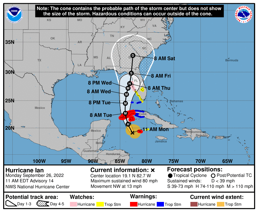
FORECAST POSITIONS AND MAX WINDS
INIT 26/1500Z 19.1N 82.7W 70 KT 80 MPH
12H 27/0000Z 20.7N 83.5W 90 KT 105 MPH
24H 27/1200Z 22.7N 84.0W 105 KT 120 MPH
36H 28/0000Z 24.5N 84.0W 120 KT 140 MPH
48H 28/1200Z 26.1N 83.8W 120 KT 140 MPH
60H 29/0000Z 27.2N 83.5W 105 KT 120 MPH
72H 29/1200Z 28.0N 83.2W 90 KT 105 MPH
96H 30/1200Z 29.8N 82.9W 55 KT 65 MPH...INLAND
120H 01/1200Z 32.8N 82.6W 30 KT 35 MPH...INLAND
Unfortunately, it's game on for Hurricane Ian, as the storm is rapidly intensifying, with winds up to 100 mph (a 20 mph increase over 6 hours) and much more impressive circulation, deep convection, symmetry and outflow, all hallmarks of a rapidly intensifying system. Unfortunately, Ian is forecast to be up to 120 mph as it crosses the far west end of Cuba tomorrow morning and to reach up to 140 mph as it reaches the latitude of Key West on Wednesday morning (but it will be over 100 miles west of KW at that time, so impacts there should not be major, although 2-4' storm surge could lead to significant flooding).
The storm is forecast to weaken some (good for obvious reasons) and to slow down (bad, as it will extend the time of surge/winds/rain) as it then travels NNE towards Tampa, given predicted increases in SW shear from the approaching major front in the eastern US, but is still forecast to be at 115 mph as it just about makes landfall in the Tampa/St. Petersburg area Thursday morning (the forecast has it being about 20 miles off the coast of St. Pete Thursday morning) and the forecast then has it further weakening to about 85 mph as it makes landfall somewhere between Clearwater and Cedar Key Thursday evening.
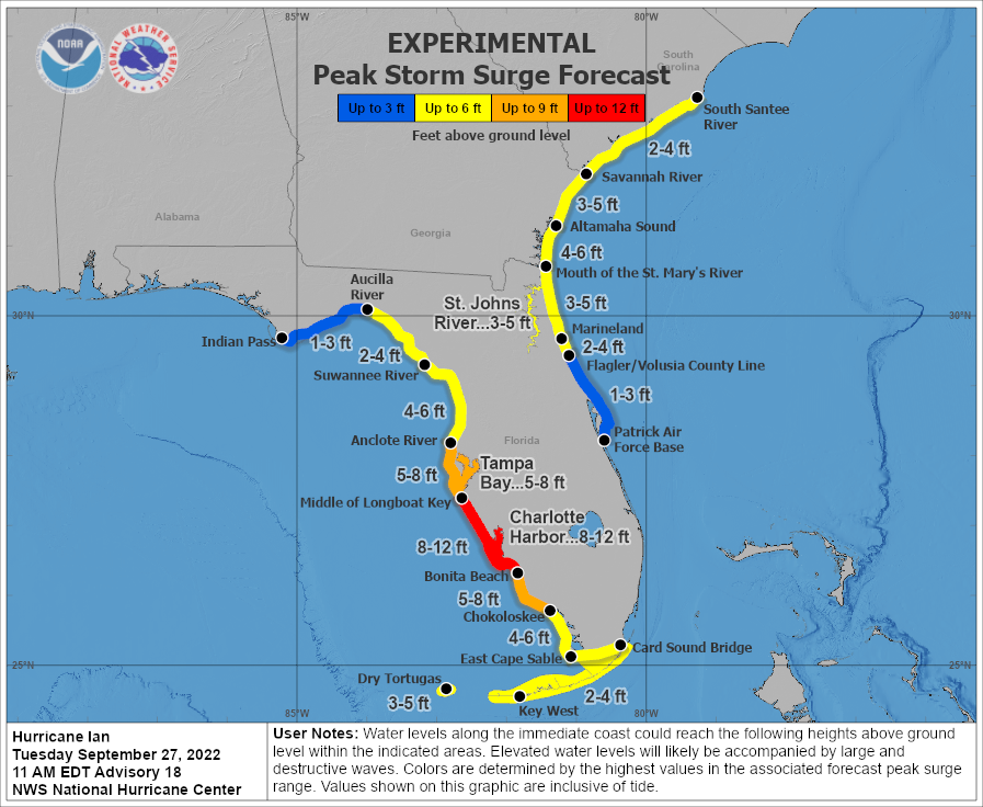
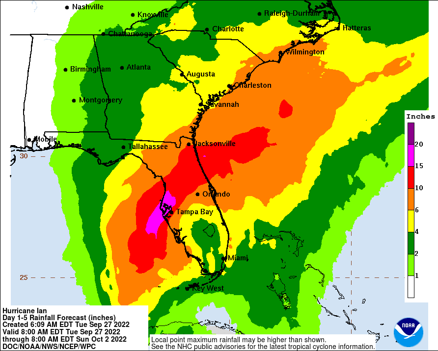
Having said that, the cone of uncertainty still includes landfall potential anywhere from Ft. Myers to Apalachicola and impacts in that entire area will be significant, including well inland. Storm surges of 5-10 feet area being predicted for the Tampa/St. Pete area (including all of the Tampa Bay) and 4-8' north of there to the Suwanee River and south of there to about Ft. Myers, as per the graphic below. This will be major to catastrophic in most of those locations. The NHC is even predicting 2-4' surges for NE FL and SE GA. Obviously, 115+ mph winds could bring major damage and even 85 mph winds can bring damage as the storm weakens some. In addition, widespread rainfall of 6-10" will be common throughout almost all of Florida (and locally more, especially near Tampa), as per the graphic below, which will lead to major flooding. And finally, storms like this always bring the threat of tornadoes, especially to the NE and E of the storm's center, which will include most of Florida.
Beyond Florida, the storm will slowly weaken to a TS in northern Florida, near Jacksonville, and then a tropical depression/remnant low near the Augusta GA area by Saturday afternoon, where the main threats will be flooding rains (4-6" possible) and possible tornadoes. Impacts for our area are not expected to be major, as rain from the remnant low by Sunday is the only threat - and we could use the rain - but the remnants may miss to our SE. Ian is not expected to reemerge into the Atlantic to regain TS status.
https://www.nhc.noaa.gov/graphics_at4.shtml?start#contents
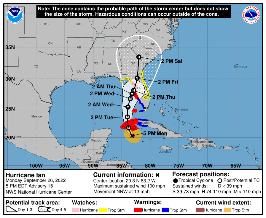
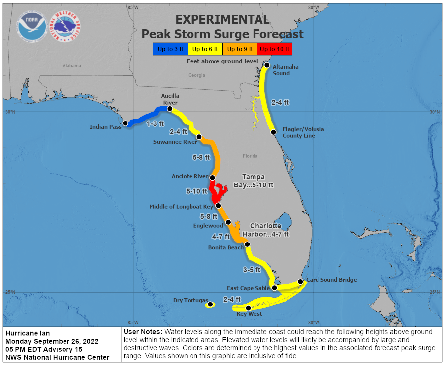
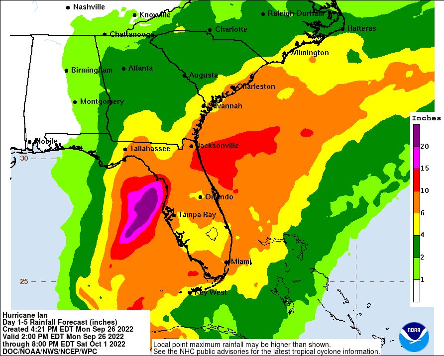
FORECAST POSITIONS AND MAX WINDS
INIT 26/2100Z 20.3N 83.2W 85 KT 100 MPH
12H 27/0600Z 21.7N 83.8W 105 KT 120 MPH
24H 27/1800Z 23.6N 84.0W 115 KT 130 MPH
36H 28/0600Z 25.3N 83.9W 120 KT 140 MPH
48H 28/1800Z 26.7N 83.5W 115 KT 130 MPH
60H 29/0600Z 27.5N 83.2W 100 KT 115 MPH
72H 29/1800Z 28.1N 82.9W 75 KT 85 MPH
96H 30/1800Z 30.1N 82.3W 45 KT 50 MPH...INLAND
120H 01/1800Z 33.5N 82.0W 25 KT 30 MPH...INLAND
But the problem is the aftermath, right?No idea, but given the forecast, no need to cancel at this time, as the storm should be well NE of Tallahassee by 8 am and the game is at 3:30 pm. However, I suspect they'll cancel out of caution in case the forecast changes (always possible).
For some locations, yes, but if the NHC forecast track is close to correct, Tallahassee will be well to the west of that track, on the weak side of the storm, so all they'll likely see is some tropical storm force winds and heavy rain, but likely not damaging winds nor flooding rains and they're very unlikely to see any tornadoes, so the aftermath will likely not be much of an issue.But the problem is the aftermath, right?
Smart move - Thursday and Friday in JAX will be a mess (and potentially dangerous)...Canceled my business trip to Jacksonville on Wednesday night.
Looks to be bad.
My guess is yes as the cone of uncertainty does have Atlanta in its sights. I guess the question is if the games can’t be played - what is plan b? I would guess neutral site.I wonder if Mets/Braves will be affected this weekend
In the grand scheme of things, this is a petty issue compared to what people may have to deal with due to the storm.
College GameDay is in Clemson on Saturday. It's going to be great to see everyone get drenched.
You've never seen cars that ran out of gas on the highways during evacuations?
You lost
The 11 pm advisory is the worst case scenario with regard to track, as the forecast track was shifted about 15 miles east, putting landfall right around St. Pete Beach on Thursday morning with 110-120 mph winds, meaning Tampa Bay would be just on the NE or more powerful quadrant of the storm at landfall, which would likely make for catastrophic storm surge right up into the Bay and into downtown Tampa Bay. And the catastrophic storm surge would extend down to about Fort Myers with even Naples at risk.If you live in Florida anywhere near the Gulf Coast from Apalachicola to Ft. Myers, and especially anywhere within 20-30 miles of Tampa/St. Pete, it's time to start thinking about rushing preparations to completion or perhaps evacuating.
Unfortunately, it's game on for Hurricane Ian, as the storm is rapidly intensifying, with winds up to 100 mph (a 20 mph increase over 6 hours) and much more impressive circulation, deep convection, symmetry and outflow, all hallmarks of a rapidly intensifying system. Unfortunately, Ian is forecast to be up to 120 mph as it crosses the far west end of Cuba tomorrow morning and to reach up to 140 mph as it reaches the latitude of Key West on Wednesday morning (but it will be over 100 miles west of KW at that time, so impacts there should not be major, although 2-4' storm surge could lead to significant flooding).
The storm is forecast to weaken some (good for obvious reasons) and to slow down (bad, as it will extend the time of surge/winds/rain) as it then travels NNE towards Tampa, given predicted increases in SW shear from the approaching major front in the eastern US, but is still forecast to be at 115 mph as it just about makes landfall in the Tampa/St. Petersburg area Thursday morning (the forecast has it being about 20 miles off the coast of St. Pete Thursday morning) and the forecast then has it further weakening to about 85 mph as it makes landfall somewhere between Clearwater and Cedar Key Thursday evening.
Having said that, the cone of uncertainty still includes landfall potential anywhere from Ft. Myers to Apalachicola and impacts in that entire area will be significant, including well inland. Storm surges of 5-10 feet area being predicted for the Tampa/St. Pete area (including all of the Tampa Bay) and 4-8' north of there to the Suwanee River and south of there to about Ft. Myers, as per the graphic below. This will be major to catastrophic in most of those locations. The NHC is even predicting 2-4' surges for NE FL and SE GA. Obviously, 115+ mph winds could bring major damage and even 85 mph winds can bring damage as the storm weakens some. In addition, widespread rainfall of 6-10" will be common throughout almost all of Florida (and locally more, especially near Tampa), as per the graphic below, which will lead to major flooding. And finally, storms like this always bring the threat of tornadoes, especially to the NE and E of the storm's center, which will include most of Florida.
Beyond Florida, the storm will slowly weaken to a TS in northern Florida, near Jacksonville, and then a tropical depression/remnant low near the Augusta GA area by Saturday afternoon, where the main threats will be flooding rains (4-6" possible) and possible tornadoes. Impacts for our area are not expected to be major, as rain from the remnant low by Sunday is the only threat - and we could use the rain - but the remnants may miss to our SE. Ian is not expected to reemerge into the Atlantic to regain TS status.
https://www.nhc.noaa.gov/graphics_at4.shtml?start#contents


FORECAST POSITIONS AND MAX WINDS
INIT 26/2100Z 20.3N 83.2W 85 KT 100 MPH
12H 27/0600Z 21.7N 83.8W 105 KT 120 MPH
24H 27/1800Z 23.6N 84.0W 115 KT 130 MPH
36H 28/0600Z 25.3N 83.9W 120 KT 140 MPH
48H 28/1800Z 26.7N 83.5W 115 KT 130 MPH
60H 29/0600Z 27.5N 83.2W 100 KT 115 MPH
72H 29/1800Z 28.1N 82.9W 75 KT 85 MPH
96H 30/1800Z 30.1N 82.3W 45 KT 50 MPH...INLAND
120H 01/1800Z 33.5N 82.0W 25 KT 30 MPH...INLAND
Ian is up to 105 mph, so the strengthening has at least slowed down a bit, but the storm is still forecast to reach 140 mph off the coast of SW FL before weakening some before landfall (hopefully). The storm is still 60 hours from landfall, but the cone of uncertainty is narrowing, meaning the error on the track and intensity forecast has gone down considerably (but there's still some uncertainty). The rest of the impacts outlined in the quoted post are largely unchanged.
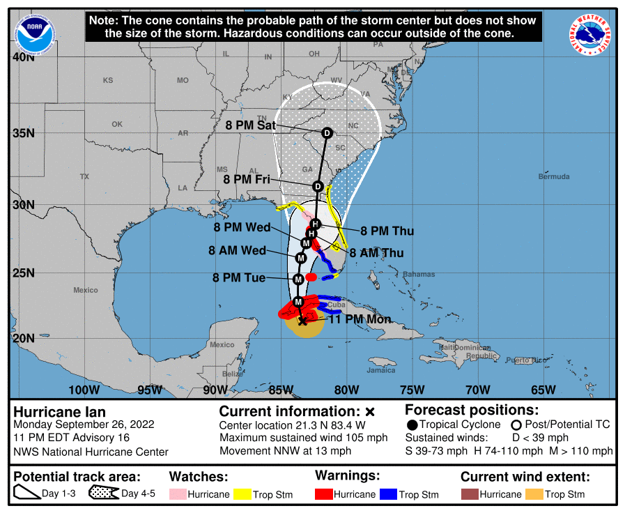
FORECAST POSITIONS AND MAX WINDS
INIT 27/0300Z 21.3N 83.4W 90 KT 105 MPH
12H 27/1200Z 22.8N 83.7W 105 KT 120 MPH
24H 28/0000Z 24.5N 83.7W 120 KT 140 MPH
36H 28/1200Z 26.1N 83.5W 115 KT 130 MPH
48H 29/0000Z 27.2N 83.1W 105 KT 120 MPH
60H 29/1200Z 27.9N 82.7W 95 KT 110 MPH...INLAND
72H 30/0000Z 28.6N 82.4W 65 KT 75 MPH...INLAND
96H 01/0000Z 31.3N 82.2W 30 KT 35 MPH...INLAND
120H 02/0000Z 35.0N 81.5W 25 KT 30 MPH...INLAND
Worth noting that we haven't seen a major hurricane hit the Tampa area in 101 years and the population has gone from 300K to 3MM since then, so this is a setup for catastrophe if the current forecast holds.
electric car batteries last for 30 hours when the car is not moving.You've never seen cars that ran out of gas on the highways during evacuations?
OK, so where do you go to fill up a can of electricity, Ace?You've never seen cars that ran out of gas on the highways during evacuations?
The 11 pm advisory is the worst case scenario with regard to track, as the forecast track was shifted about 15 miles east, putting landfall right around St. Pete Beach on Thursday morning with 110-120 mph winds, meaning Tampa Bay would be just on the NE or more powerful quadrant of the storm at landfall, which would likely make for catastrophic storm surge right up into the Bay and into downtown Tampa Bay. And the catastrophic storm surge would extend down to about Fort Myers with even Naples at risk.
Ian is up to 105 mph, so the strengthening has at least slowed down a bit, but the storm is still forecast to reach 140 mph off the coast of SW FL before weakening some before landfall (hopefully). The storm is still 60 hours from landfall, but the cone of uncertainty is narrowing, meaning the error on the track and intensity forecast has gone down considerably (but there's still some uncertainty). The rest of the impacts outlined in the quoted post are largely unchanged.

FORECAST POSITIONS AND MAX WINDS
INIT 27/0300Z 21.3N 83.4W 90 KT 105 MPH
12H 27/1200Z 22.8N 83.7W 105 KT 120 MPH
24H 28/0000Z 24.5N 83.7W 120 KT 140 MPH
36H 28/1200Z 26.1N 83.5W 115 KT 130 MPH
48H 29/0000Z 27.2N 83.1W 105 KT 120 MPH
60H 29/1200Z 27.9N 82.7W 95 KT 110 MPH...INLAND
72H 30/0000Z 28.6N 82.4W 65 KT 75 MPH...INLAND
96H 01/0000Z 31.3N 82.2W 30 KT 35 MPH...INLAND
120H 02/0000Z 35.0N 81.5W 25 KT 30 MPH...INLAND
Ian made landfall around 3:30 am in western Cuba with 125 mph winds and damage is reportedly devastating to areas close to the storm. The 5 am advisory moved the track of Ian SE about 10 miles so landfall would be right up the Tampa Bay sometime Thursday morning, instead of on St. Pete Beach. No significant changes in intensity forecast, as Ian is still forecast to strengthen from the current 125 mph winds to 140 mph over the next day or so (Cat 4), but to weaken to about 120 mph (Cat 3) at landfall, due to increased SW shear (but I'd hate to be relying on that). Given the SE-ward shift in the track over the past couple of model cycles, the one significant forecast change from the NHC has been to extend the 5-10 foot storm surge forecast south to Bonita Beach, just south of Ft. Myers. Note that if the storm track shifts any further SE, Tampa/St. Pete would be spared the worst of the storm surge. Since the 11 am advisory comes out shortly, will update this including updated graphics around then.
Petty but yet you provided an answer.My guess is yes as the cone of uncertainty does have Atlanta in its sights. I guess the question is if the games can’t be played - what is plan b? I would guess neutral site.
In the grand scheme of things, this is a petty issue compared to what people may have to deal with due to the storm.
Wow, the NHC made a significant shift of about 30 miles SE in Ian's track: instead of landfall right into Tampa Bay, it's now forecast to be between Sarasota and Ft. Myers, which would spare Tampa the worst of the surge/winds and bring that worst surge and winds to areas from Naples to Sarasota - if the current forecast holds - remember, we're still 36-48 hours from landfall so some changes can still occur from here. Don't have time for a full analysis, but below are the various updated graphics for the storm.Ian made landfall around 3:30 am in western Cuba with 125 mph winds and damage is reportedly devastating to areas close to the storm. The 5 am advisory moved the track of Ian SE about 10 miles so landfall would be right up the Tampa Bay sometime Thursday morning, instead of on St. Pete Beach. No significant changes in intensity forecast, as Ian is still forecast to strengthen from the current 125 mph winds to 140 mph over the next day or so (Cat 4), but to weaken to about 120 mph (Cat 3) at landfall, due to increased SW shear (but I'd hate to be relying on that). Given the SE-ward shift in the track over the past couple of model cycles, the one significant forecast change from the NHC has been to extend the 5-10 foot storm surge forecast south to Bonita Beach, just south of Ft. Myers. Note that if the storm track shifts any further SE, Tampa/St. Pete would be spared the worst of the storm surge. Since the 11 am advisory comes out shortly, will update this including updated graphics around then.
https://www.nhc.noaa.gov/graphics_at4.shtml?start#contents
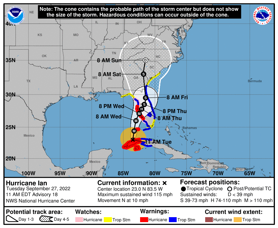
FORECAST POSITIONS AND MAX WINDS
INIT 27/1500Z 23.0N 83.5W 100 KT 115 MPH
12H 28/0000Z 24.4N 83.3W 115 KT 130 MPH
24H 28/1200Z 26.0N 83.0W 115 KT 130 MPH
36H 29/0000Z 27.1N 82.5W 110 KT 125 MPH
48H 29/1200Z 27.8N 82.1W 75 KT 85 MPH...INLAND
60H 30/0000Z 28.5N 81.7W 60 KT 70 MPH...INLAND
72H 30/1200Z 29.5N 81.5W 50 KT 60 MPH...INLAND
96H 01/1200Z 33.0N 81.8W 35 KT 40 MPH...INLAND
120H 02/1200Z 35.0N 81.5W 25 KT 30 MPH...POST-TROP/EXTRATROP
We moved to St. Augustine in April. Just got our storm surge warning as we’re about 10 miles from the ocean and maybe 5 from the St. John’s river. Nobody seems terribly concerned, but there’s definitely an air of caution as we run errands. They’re forecasting for 8-12” of rain and tropical storm winds starting mid-day Thursday.
As well you should.I started a separate thread for soon-to-be-Hermine.
New event = new thread.
This Ian is now a big deal and many of us have family and friends affected by it.
It warrants its own coverage.
I will say, @RU848789 you seem to be one of the few who have listed Cuba as place to be concerned about. It’s like others don’t care. 🤷♂️
Last edited:
There is a precedent for the neutral site. We have seen it in football. As a Cubs fan, I remember the Cubs playing the Astros in Milwaukee due to Ike. Carlos Zambrano threw a no hitter.My guess is yes as the cone of uncertainty does have Atlanta in its sights. I guess the question is if the games can’t be played - what is plan b? I would guess neutral site.
In the grand scheme of things, this is a petty issue compared to what people may have to deal with due to the storm.
I have lived in the Jacksonville/Ponte Vedra area for 30+ years. Unless you have a home on the St. Johns or a creek off the river you should be absolutely fine from a flooding perspective. I have been perfectly safe evacuating to 95 and you are likely west of that. If the house is new then the roof and windows will provide more than enough safety from the expected wind. Biggest fear is from trees rather than water. Other good news is that if you lose power it is usually for a very short period after the storm.We moved to St. Augustine in April. Just got our storm surge warning as we’re about 10 miles from the ocean and maybe 5 from the St. John’s river. Nobody seems terribly concerned, but there’s definitely an air of caution as we run errands. They’re forecasting for 8-12” of rain and tropical storm winds starting mid-day Thursday.
As an FYI - my aunt lives in a retirement home in Ponte Vedra less than a mile from both the intracoastal and Ocean. They are not evacuating as of 12:00 Tuesday.
Good luck.
Thanks, you too. My parents are in Nocatee. We’re maybe 2 miles west of 95 and the house is 3 years old. We’ll be ready to ride it out!I have lived in the Jacksonville/Ponte Vedra area for 30+ years. Unless you have a home on the St. Johns or a creek off the river you should be absolutely fine from a flooding perspective. I have been perfectly safe evacuating to 95 and you are likely west of that. If the house is new then the roof and windows will provide more than enough safety from the expected wind. Biggest fear is from trees rather than water. Other good news is that if you lose power it is usually for a very short period after the storm.
As an FYI - my aunt lives in a retirement home in Ponte Vedra less than a mile from both the intracoastal and Ocean. They are not evacuating as of 12:00 Tuesday.
Good luck.
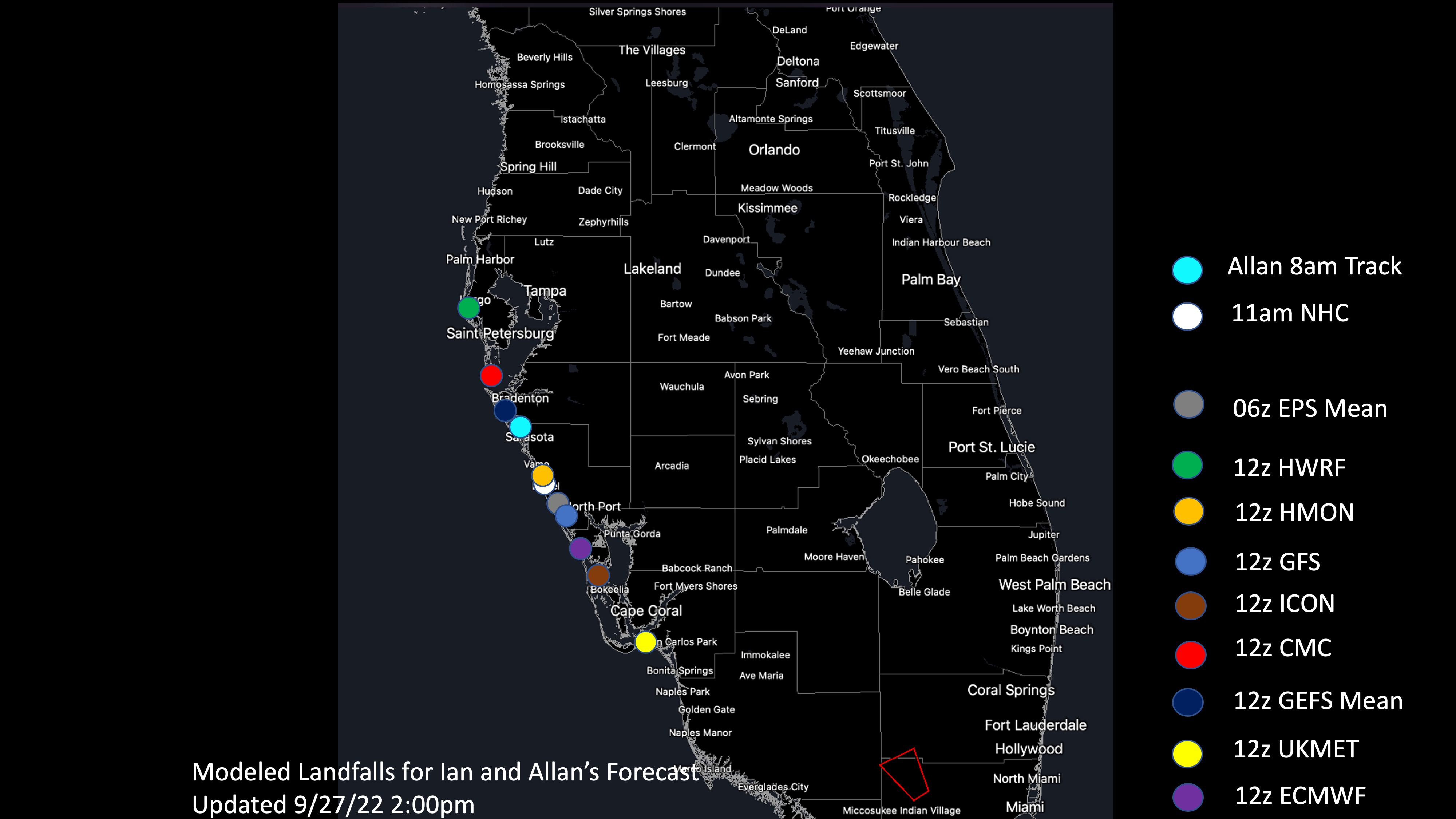
Great graphic from a met on AmericanWx, showing all of the landfall locations from the 12Z model suite from a few hours ago. Everywhere from Tampa to Fort Myers needs to be on high alert for landfall, and especially everyone from about Sarasota to Port Charlotte - and with regard to storm surge and the highest winds, everyone south to at least Naples could easily be in the worst of it, especially if the track shifts any further south. At the 2 pm advisory, Ian had strengthened back up to 120 mph winds and looks like it will still get stronger. Next NHC update is at 5 pm. People along the FL Gulf Coast have until about 6 am tomorrow to finish preps and/or evacuate, as conditions will start going really downhill after that. Back to the beach for me, lol.

Way too late for a new thread and I've updated the thread title regularly, so people should know this is the thread for this storm. And people should care about death and destruction anywhere, but especially in the US and nearby places where people likely have family and friends.As well you should.
New event = new thread.
This Ian is now a big deal and many of us have family and friends affected by it.
It warrants its own coverage.
I will say, @RU848789 you seem to be one of the few who have listed Cuba as place to be concerned about. It’s like others don’t care. 🤷♂️
unlikely anything significant - hopefully some rain, as we need it, but wind is very unlikely, unless Ian reemerges into the Atlantic after going inland through GA/SC/NC, which is a possibility - but even then, significant impacts are unlikely to make it north of DelMarVa (but need to still watch it closely). And it could be a close call with how far north heavy rain comes, as per the graphic below...Wow . This looks bad .
any effects for nj ?

Last edited:
As we have discussed in the past the mobile aspect makes it a pain in ass to follow threads like this.Way too late for a new thread and I've updated the thread title regularly, so people should know this is the thread for this storm. And people should care about death and destruction anywhere, but especially in the US and nearby places where people likely have family and friends.
The next one, new thread. Please. 😉
But back to Cuba…I still find it weird how little coverage/concern there seems to be. Granted our media should be more concerned about CONUS but even CNN and the BBC (for example), not so much with regard to Fidel’s place.
Wow, the NHC made a significant shift of about 30 miles SE in Ian's track: instead of landfall right into Tampa Bay, it's now forecast to be between Sarasota and Ft. Myers, which would spare Tampa the worst of the surge/winds and bring that worst surge and winds to areas from Naples to Sarasota - if the current forecast holds - remember, we're still 36-48 hours from landfall so some changes can still occur from here. Don't have time for a full analysis, but below are the various updated graphics for the storm.
https://www.nhc.noaa.gov/graphics_at4.shtml?start#contents


FORECAST POSITIONS AND MAX WINDS
INIT 27/1500Z 23.0N 83.5W 100 KT 115 MPH
12H 28/0000Z 24.4N 83.3W 115 KT 130 MPH
24H 28/1200Z 26.0N 83.0W 115 KT 130 MPH
36H 29/0000Z 27.1N 82.5W 110 KT 125 MPH
48H 29/1200Z 27.8N 82.1W 75 KT 85 MPH...INLAND
60H 30/0000Z 28.5N 81.7W 60 KT 70 MPH...INLAND
72H 30/1200Z 29.5N 81.5W 50 KT 60 MPH...INLAND
96H 01/1200Z 33.0N 81.8W 35 KT 40 MPH...INLAND
120H 02/1200Z 35.0N 81.5W 25 KT 30 MPH...POST-TROP/EXTRATROP
Summary: the models and the NHC are predicting another shift SE with the track, which probably will spare Tampa/St. Pete the worst impacts, but will bring the worst impacts (6-10'+ surge and 120-125 mph winds at the coast and even 100 mph winds a bit inland, plus torrential rains everywhere) from about Sarasota down through Fort Myers and probably even Naples. If you're in an area at high risk of storm surge and/or where the highest winds will be, evacuation is your best option. Now. For others, consult your local officials for guidance.
Details: As mentioned a bit earlier, the 12Z models showed an even further shift SE for Ian's track relative to the 11 am NHC advisory, so with the 5 pm advisory, the track was shifted another ~15 miles SE, which might not sound like much, but, if it verifies (and we're now within 24-30 hours of landfall, so errors and forecast uncertainty are getting much smaller), will have a huge impact on many coastal locations.
So, the official forecast has landfall right around Port Charlotte and locations from about Sarasota down to Naples could also see that landfall, given the uncertainties; see the first graphic. Tampa isn't officially out of the cone, but it seems very unlikely now to bear the brunt of a direct hit, which is major good news for that highly populated area (i.e., much less surge and lower winds).
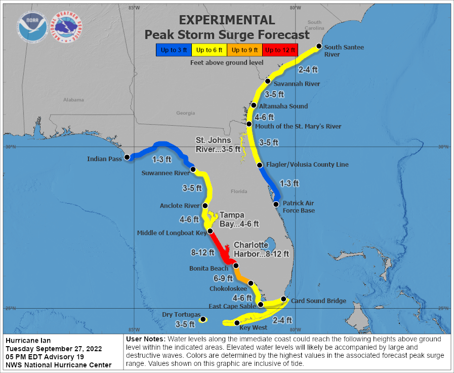
From landfall to about 20-30 miles SE of landfall (Port Charlotte to Bonita Beach as of now), where the most powerful winds are and where wind direction is directly on-shore, storm surge is likely to be catastrophic, i.e., 6-10 feet with locally up to 12 feet above the normal high tide level. And even another 20 miles south of Bonita Beach, down through Naples, 5-8' surge is forecast, which is close to catastrophic for many. The currently predicted surge is the 2nd graphic below. Obviously, areas along and SE of the track will also be seeing the worst winds of 120-125 mph at landfall, so damage in those areas along the coast from winds could be catastrophic and even 20-30 miles inland where ~100 mph gusts are still likely, wind damage will likely be substantial. Power outages will be widespread throughout most of the state.
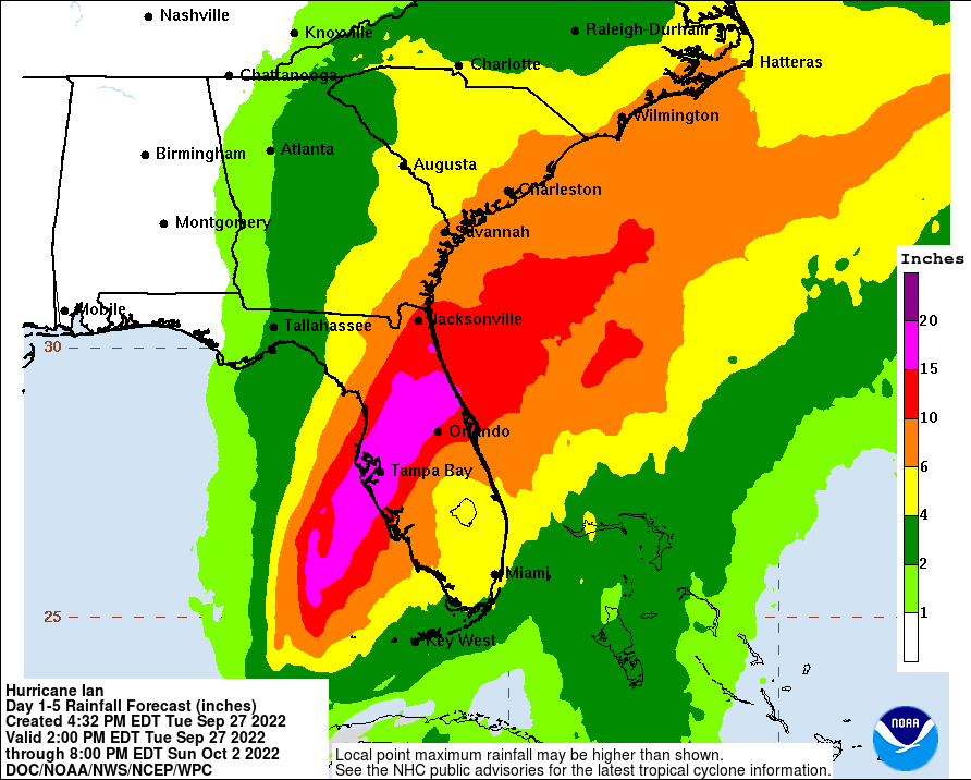
In addition, for much of the state of Florida, 6-10" of rain or more are forecast, with a large swath of 15-20" rains from Tampa to Orlando to Daytona Beach. These will be torrential, flooding rains that will become life-threatening for some. See the rainfall graphic below. Also, we can't forget that isolated tornadoes usually accompany landfalling hurricanes, especially along and east of the track, meaning much of FL will be at risk of small tornadoes that can still do major damage.
Even up through Jacksonville and coastal GA/SC, up to 10" of rain is currently forecast, with lesser amounts inland, as Ian is expected to cross from SW FL to NE FL from Wednesday thru Friday and it might even emerge in the Atlantic off the coast of NE FL/GA for a bit, before making another landfall, as a moderate tropical storm somewhere in GA/SC, after which the storm should dissipate in interior SC/NC by Saturday afternoon. There are even 3-5' storm surges predicted for parts of NE FL, GA, and SC, which will bring some flooding to those areas. Lastly, impacts to our area should be mainly just rain, which is needed, but the heaviest rains are likely to stay down towards the DelMarVa.
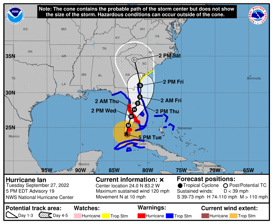
FORECAST POSITIONS AND MAX WINDS
INIT 27/2100Z 24.0N 83.2W 105 KT 120 MPH
12H 28/0600Z 25.3N 82.9W 115 KT 130 MPH
24H 28/1800Z 26.6N 82.5W 115 KT 130 MPH
36H 29/0600Z 27.6N 82.0W 70 KT 80 MPH...INLAND
48H 29/1800Z 28.5N 81.5W 55 KT 65 MPH...INLAND
60H 30/0600Z 29.4N 81.2W 45 KT 50 MPH...INLAND
72H 30/1800Z 31.0N 81.1W 45 KT 50 MPH...OVER WATER
96H 01/1800Z 34.5N 82.0W 25 KT 30 MPH...POST-TROP/EXTRATROP
120H 02/1800Z...DISSIPATED
Similar threads
- Replies
- 553
- Views
- 33K
- Replies
- 373
- Views
- 18K
- Replies
- 488
- Views
- 21K
- Replies
- 13
- Views
- 772
ADVERTISEMENT
ADVERTISEMENT
