What about Venice Florida?
I know people there looks like it could be ground zero.
What do you say on this?
Venice looking problematic.
What about Venice Florida?
I know people there looks like it could be ground zero.
What do you say on this?
Not sure. I think they can do fishing, but we were more into sightseeing and checking out secluded beaches.
I'm aware, as are they. They're closer to 75 than the waterfront so storm surge isn't an immediate threat. They're in a newer development with new hurricane glass and hurricane shutters. Old fart stubbornness is real.I'm sure you know much of this, but remember, Irma was a 115 mph Cat 3 that struck Marco Island, about 15-20 miles south of Naples, meaning Naples was on the weak side of the storm. If Ian comes ashore around Port Charlotte (~60 miles north), as a 125-130 mph storm as currently forecast, I'd agree that Naples will not have much more than maybe 70 mph gusts, but the surge is still going to be significantly greater than what it was for Irma, being on the strong side of the storm. And if the track moves another 20 miles south, Naples could then experience catastrophic storm surge and hurricane force winds.
The little one likes to go fast! :)Ah.
That's... very manly.
Power boats is for fishin'. Everything else is sailing.
Or a long winded thread that started in June. 😉You must've gone to charm school. T2K pulled the same crap on the run-up to Sandy, downplaying the potential impacts right up until landfall, as he thinks trolling is even ok in life and death scenarios. And I get that people should likely be seeking critical safety info from official sources, but there are some who do come here and other message boards for such info and they shouldn't have to put up with his crap.
HA! HA! e5fdny from downtown:Or a long winded thread that started in June. 😉

Summary: the models and the NHC are predicting another shift SE with the track, which probably will spare Tampa/St. Pete the worst impacts, but will bring the worst impacts (6-10'+ surge and 120-125 mph winds at the coast and even 100 mph winds a bit inland, plus torrential rains everywhere) from about Sarasota down through Fort Myers and probably even Naples. If you're in an area at high risk of storm surge and/or where the highest winds will be, evacuation is your best option. Now. For others, consult your local officials for guidance.
Details: As mentioned a bit earlier, the 12Z models showed an even further shift SE for Ian's track relative to the 11 am NHC advisory, so with the 5 pm advisory, the track was shifted another ~15 miles SE, which might not sound like much, but, if it verifies (and we're now within 24-30 hours of landfall, so errors and forecast uncertainty are getting much smaller), will have a huge impact on many coastal locations.
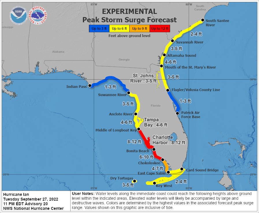
So, the official forecast has landfall right around Port Charlotte and locations from about Sarasota down to Naples could also see that landfall, given the uncertainties; see the first graphic. Tampa isn't officially out of the cone, but it seems very unlikely now to bear the brunt of a direct hit, which is major good news for that highly populated area (i.e., much less surge and lower winds).
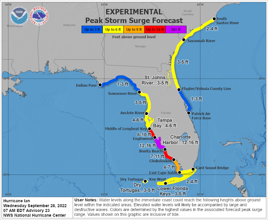
From landfall to about 20-30 miles SE of landfall (Port Charlotte to Bonita Beach as of now), where the most powerful winds are and where wind direction is directly on-shore, storm surge is likely to be catastrophic, i.e., 6-10 feet with locally up to 12 feet above the normal high tide level. And even another 20 miles south of Bonita Beach, down through Naples, 5-8' surge is forecast, which is close to catastrophic for many. The currently predicted surge is the 2nd graphic below. Obviously, areas along and SE of the track will also be seeing the worst winds of 120-125 mph at landfall, so damage in those areas along the coast from winds could be catastrophic and even 20-30 miles inland where ~100 mph gusts are still likely, wind damage will likely be substantial. Power outages will be widespread throughout most of the state.
In addition, for much of the state of Florida, 6-10" of rain or more are forecast, with a large swath of 15-20" rains from Tampa to Orlando to Daytona Beach. These will be torrential, flooding rains that will become life-threatening for some. See the rainfall graphic below. Also, we can't forget that isolated tornadoes usually accompany landfalling hurricanes, especially along and east of the track, meaning much of FL will be at risk of small tornadoes that can still do major damage.
Even up through Jacksonville and coastal GA/SC, up to 10" of rain is currently forecast, with lesser amounts inland, as Ian is expected to cross from SW FL to NE FL from Wednesday thru Friday and it might even emerge in the Atlantic off the coast of NE FL/GA for a bit, before making another landfall, as a moderate tropical storm somewhere in GA/SC, after which the storm should dissipate in interior SC/NC by Saturday afternoon. There are even 3-5' storm surges predicted for parts of NE FL, GA, and SC, which will bring some flooding to those areas. Lastly, impacts to our area should be mainly just rain, which is needed, but the heaviest rains are likely to stay down towards the DelMarVa.
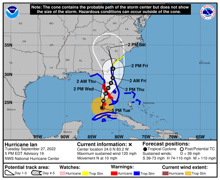
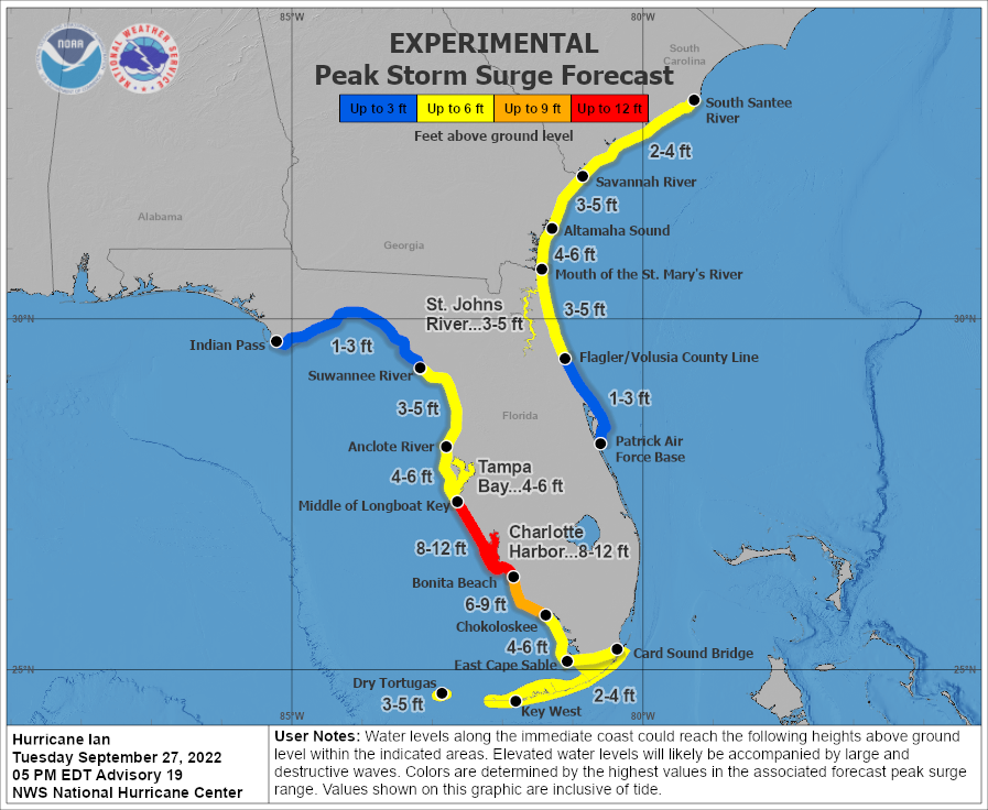
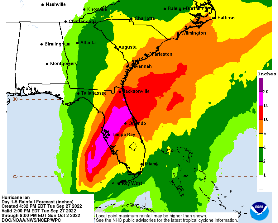
FORECAST POSITIONS AND MAX WINDS
INIT 27/2100Z 24.0N 83.2W 105 KT 120 MPH
12H 28/0600Z 25.3N 82.9W 115 KT 130 MPH
24H 28/1800Z 26.6N 82.5W 115 KT 130 MPH
36H 29/0600Z 27.6N 82.0W 70 KT 80 MPH...INLAND
48H 29/1800Z 28.5N 81.5W 55 KT 65 MPH...INLAND
60H 30/0600Z 29.4N 81.2W 45 KT 50 MPH...INLAND
72H 30/1800Z 31.0N 81.1W 45 KT 50 MPH...OVER WATER
96H 01/1800Z 34.5N 82.0W 25 KT 30 MPH...POST-TROP/EXTRATROP
120H 02/1800Z...DISSIPATED
Sorry, but this will likely be much worse than anything they've ever seen, especially in Cape Coral. Charley was a fast moving, small storm, while Ian is a slow moving, large storm, meaning much more storm surge, rain and prolonged winds.My mom, my sister, her daughter, son-in-law, and three kids all live in Cape Coral....just outside Fort Myers. Scary times....though they've been down there for years and have been through this crap before.
We were barely past 1/2 page of posts when I started talking about a vigorous tropical wave last Tuesday evening (before 4Real started his thread), which eventually became Ian, so not very long-winded. The mods folded his thread into this one. And I've updated the thread title a few times to reflect Ian's importance. Respectfully, you're feeding the troll here, which isn't helpful.Or a long winded thread that started in June. 😉
@RU4Real was doing pretty good with his. Or did it merge?
You know my opinion on this…We were barely past 1/2 page of posts when I started talking about a vigorous tropical wave last Tuesday evening (before 4Real started his thread), which eventually became Ian, so not very long-winded. The mods folded his thread into this one. And I've updated the thread title a few times to reflect Ian's importance. Respectfully, you're feeding the troll here, which isn't helpful.
When Charley hit this area, there was widespread destruction. I remember many families living in downtown Tampa hotels.The storm has been upgraded to a category 4 hurricane as of 5 AM. Top sustained winds of 140 mph. Pressure down to 942 millibars. The center projected to be on Fla. coast by late this afternoon around the Port Charlotte, Punta Gorda region.
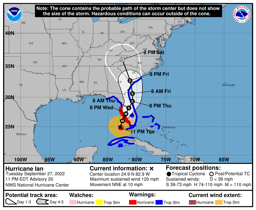
The 11 pm NHC advisory is in and there is only a small SE shift in Ian's forecast track, as landfall has shifted about 10 miles SE from about Englewood to Boca Grande (the barrier island) up through the Port Charlotte/Punta Gorda area in SW FL, around mid/late afternoon tomorrow, and given that we're within 18 hours of landfall, the uncertainty on that track is shrinking rapidly, so landfall will now almost certainly be within 15-20 miles of the forecast track, i.e., between about Venice and Captiva (and inland to Ft. Myers).
Winds are at 120 mph and are forecast to be 130 mph at landfall (low end Cat 4) and are still forecast to be around 75 mph as the storm reaches Orlando by around noon on Thursday. The only noteworthy change in predicted impacts vs. 5 pm was increasing the storm surge forecast from Bonita Beach to Everglades City (which includes Naples and Marco Island) to 6-10', which will likely result in catastrophic surge in some areas. Incredible rainfall amounts up to 20"+ are still being forecast for large parts of Florida and isolated tornadoes are also forecast (and have been seen already).
FYI, Ian has mostly completed an "eyewall replacement cycle" and is still looking pretty healthy and the further SE and earlier landfall is making it more likely the forecast SW shear from the approaching trough in the SE US will not significantly weaken the storm before landfall, as was forecast when landfall was expected to be much further north, near Tampa Bay. That's why the NHC is sticking to 130 mph winds at landfall. It's going to be a really bad day in SW FL and much of the rest of the state over the next 2 days. Some of the geeky details above are discussed in the AmericanWx thread linked below.
https://www.nhc.noaa.gov/graphics_at4.shtml?start#contents
https://www.americanwx.com/bb/topic/58177-hurricane-ian/page/80/
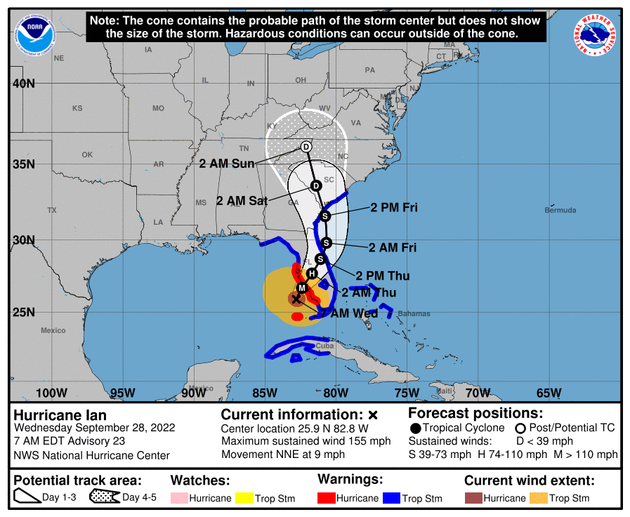

FORECAST POSITIONS AND MAX WINDS
INIT 28/0300Z 24.9N 82.9W 105 KT 120 MPH
12H 28/1200Z 26.0N 82.5W 115 KT 130 MPH
24H 29/0000Z 27.2N 81.9W 110 KT 125 MPH...INLAND
36H 29/1200Z 28.2N 81.4W 60 KT 70 MPH...INLAND
48H 30/0000Z 29.3N 80.8W 45 KT 50 MPH...OVER WATER
60H 30/1200Z 30.6N 80.8W 45 KT 50 MPH
72H 01/0000Z 32.7N 81.2W 30 KT 35 MPH...INLAND
96H 02/0000Z 36.0N 82.5W 25 KT 30 MPH...POST-TROP/INLAND
120H 03/0000Z...DISSIPATED

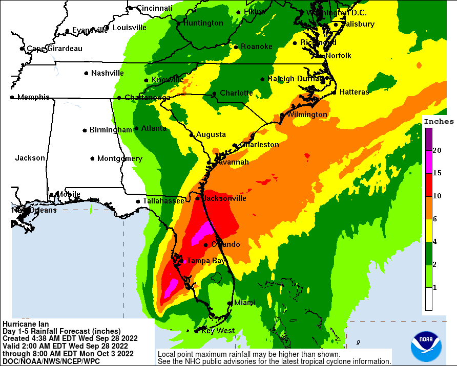
yeah, me 🤞 looking like it is going to come up I-4The projected rain totals in this thing are insane. Saw a projected 20+ inches in the Orlando area.
Appears that way. Looking at the projected path Charleston would get hit with the upper right quadrant (think us and Sandy). I think they said it would be a triple land hit by the time it gets to GA/SC.Charleston SC could get flooded out ?
How fast is this moving?
I am watching at the gym right now and it says about 55 miles from Naples yet the winds are lower than I thought they would be at this point.
No holler. The measured winds rarely verify over land, due to frictional effects, decreasing their speed (much less friction over water), combined with the fact that many weather stations tend to get obliterated before recording the highest gusts or sustained winds. That's why I tend to believe that the highest recorded gusts over land are a better indicator of the winds being actually felt in that area.9 mph at present.
@RU848789 probably gonna holler at this, but as a veteran of a few of these storms I can tell you that these max winds are not generally widespread. You don't have to get very far from the Quadrant 1 eyewall to see average wind speeds drop from these max winds that get reported - winds which, as a reminder, the recon flights spend a couple hours actually searching for.
The wind speed that's important in these situations is the one lifting the roof from your house.
And Charley was a much smaller (1/3 the size of Ian), fast moving storm, limiting damage, especially storm surge. Ian will be much worse, especially with the upgrade to 155 mph winds. I can only imagine what would have happened if Ian kept its track towards Tampa with this kind of strength with 3+MM people in its path.When Charley hit this area, there was widespread destruction. I remember many families living in downtown Tampa hotels.
By the way, Cantore is in Punta Gorda, so no surprise that's likely ground zero...


A pretty scary tweet and graphic on the very likely coming storm surge for the Port Charlotte/Punta Gorda/Fort Myers area, showing how much land will likely become submerged...
44 tornado warnings from Ian, so far, and many more to come...
And here's another interesting tidbit I came across (American Wx), stating that the western eyewall looks to be as strong as the NE eyewall, which is usually somewhat stronger.
The storm has already moved north of Marco. Reports are pretty good. Naples should be only modestly impacted as well.
Yeah, 7-11 feet of storm surge for Marco to Naples to Bonita Beach is "only modestly impacted" - you really should have your posting privileges revoked in this thread. Friggin' troll - grow up.The storm has already moved north of Marco. Reports are pretty good. Naples should be only modestly impacted as well.
The storm has already moved north of Marco. Reports are pretty good. Naples should be only modestly impacted as well.
It's easier if you ignore him, but see my posts above. Hoping my friend's place not far from Tigertail Beach survives modestly unscathed.Yeah, 7-11 feet of storm surge for Marco to Naples to Bonita Beach is "only modestly impacted" - you really should have your posting privileges revoked in this thread. Friggin' troll - grow up.
Reports from the S Collier and Winterberry area are all good. Wind is diminishing. Minor flooding, but Marco is built for occasional flooding.It's easier if you ignore him, but see my posts above. Hoping my friend's place not far from Tigertail Beach survives modestly unscathed.
Reports from the S Collier and Winterberry area are all good. Wind is diminishing. Minor flooding, but Marco is built for occasional flooding.
Sorry if you guys don't like good news.
Wrong again. Dr. Postell on TWC just reported that the surge in Naples is up to almost 3 feet, the 4th highest in recorded history and will likely get to at least 7 feet which would be the worst in recorded history. Naples and Marco don't need a direct hit to have major to catastrophic storm surge, as this powerful storm is to the NNW of them bringing SW winds right onshore for the next many hours.Reports from the S Collier and Winterberry area are all good. Wind is diminishing. Minor flooding, but Marco is built for occasional flooding.
Sorry if you guys don't like good news.
Why would you post something about "good news" during this ? Not everyone is focused on the narrow areas you describe. I have family in Cape Coral, Fort Myers, and Port Charlotte who I hope will be as lucky as you suggest. Jeez. Just save it for when it's over and if it isn't as bad as predicted then you can claim "victory".Reports from the S Collier and Winterberry area are all good. Wind is diminishing. Minor flooding, but Marco is built for occasional flooding.
Sorry if you guys don't like good news.
As you know, I prefer facts, not emotion.Wrong again. Dr. Postell on TWC just reported that the surge in Naples is up to almost 3 feet, the 4th highest in recorded history and will likely get to at least 7 feet which would be the worst in recorded history. Naples and Marco don't need a direct hit to have major to catastrophic storm surge, as this powerful storm is to the NNW of them bringing SW winds right onshore for the next many hours.
So we can only comment about certain areas impacted by the storm at certain times? Please post a list of the rules. Thanks!Why would you post something about "good news" during this ? Not everyone is focused on the narrow areas you describe. I have family in Cape Coral, Fort Myers, and Port Charlotte who I hope will be as lucky as you suggest. Jeez. Just save it for when it's over and if it isn't as bad as predicted then you can claim "victory".
I think we both know your undertone is this isn't as bad as is being suggested when it has barely even begun.So we can only comment about certain areas impacted by the storm at certain times? Please post a list of the rules. Thanks!