ADVERTISEMENT

OT: Major winter storm 3/20-21?

pretty shocked that Mt Holly is being incredibly bullish seeing that outlets like WCTC have 5-10 for the area not 12-14 and tv mets settlling in 6-12 range. Dan Zarrow from 101.5 at 6-12

last night Euro did move southeast, didnt see Numbers mention that...kept those foot plus potential toward the shore but cutting most others back to 6-10. 6z NAM moved even further southeast with sharp cutoffs maybe 3-5 in central jersey but those bigger amounts only along the immediate coast. So you can see slight shifts can drastically change. Other models held serve basically so we will see today to look for any trends and if the nam/euro were on to something with their shifts
I was a little surprised they increased so much also...my thinking is more like 8-12 with local bands of 12-16".
 
I was a little surprised they increased so much also...my thinking is more like 8-12 with local bands of 12-16".


I would think 8-12 is more appropriate if they want to be bullish....even in my nws winterstormwarning its for 8-14 then why did I see a map with 12-18 inches..wtf?

that nam run today is going to be big if its consistent to last night. Also what are you thoughts on if today's wave is further south having an impact on tomorrows wave
 
Dan Zarrow....101.5

What’s the latest forecast update?
Happy First Day of Spring! Our complicated nor'easter storm system has arrived, and weather conditions will deteriorate significantly over the next 48 hours.

All week long, as both computer models and meteorologists have struggled to get a handle on this storm's impacts, I stuck to one very important rule: Given the numerous challenges of late-season snowstorms, I would not promote major snow totals unless there is sufficient evidence to support such a forecast.

in-art-close-icon-128x128-16481b937f87b244a645cdbef0d930f8.png

–– ADVERTISEMENT ––


unmiss-sound-button-muted-e74d67a0c85c3548f07d7564782a269c.svg

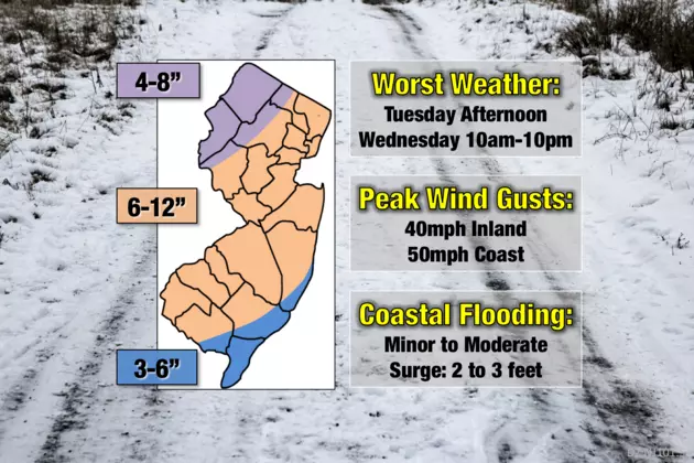
Well, there is now clear evidence that this is going to be a significant storm for New Jersey. We find ourselves right in the bullseye of snowfall from this pair of storms. My latest math shows most of the state receiving 6 inches of heavy, wet snow by Thursday morning. If heavier snow bands set up, and if surfaces are cold enough to sustain accumulation, totals will push closer to a foot.

In addition, this storm will bring the return of fierce wind gusts and coastal flooding. No matter where you live in the great Garden State, you will feel severe impacts from this storm.


Will I make it to work/school Tuesday morning?
Yes, no problem. Showers and sprinkles have started to pop in South Jersey, but the radar has been mostly quiet so far. Bands of wintry mix (mostly rain and sleet) will slowly spread through New Jersey Tuesday morning. Don't expect much to start — our atmosphere is pretty dry right now, and temperatures will be above-freezing at precipitation onset.

How does my Tuesday evening commute look?
Here's where things start to get sloppy. By Tuesday afternoon, the wintry mix will get heavier, and we'll transition to a bit more snow than rain/sleet. Given the temperature of the air and the ground, snowflakes are going to struggle to accumulate (especially on treated surfaces) initially. Still, a slushy inch or two will be possible on the roads by this evening's commute, especially along the Interstate 295 corridor in southwestern New Jersey. A bit slippery, with pockets of low visibility, but travel conditions will be mostly manageable during the day on Tuesday.

Will I make it to work/school OK Wednesday morning?
Maybe. As we transition from low pressure #1 to low pressure #2, the spread and intensity of snowfall will increase through the Wednesday morning hours. By about 9 a.m., bands of very heavy snow become possible, pushing road conditions downhill very quickly.

What about my drive home Wednesday afternoon?
Not looking good. The heaviest snowfall of the entire storm will occur from Wednesday late morning through Wednesday early evening. In the heaviest snow bands, near-zero visibility and rapid accumulation (1+ inch an hour) will be possible. I wouldn't want to be driving anywhere during that period of time (say, 10 a.m. to 10 p.m.)

Given the inclement and downright dangerous weather conditions, widespread school closings are likely on Wednesday.

When will the snow finally end?
As our storm system pushes out to sea, snowfall will taper from west to east through early Thursday morning. Snow should be done completely daybreak Thursday.

If the highest snow totals verify, I expect another round of school delays and closings on Thursday.

High temperatures will be in the 40s with increasing sunshine through the upcoming weekend, kickstarting the snow melt nicely.

Are we going to see power outages again?
Probably. Once again, with temperatures near the freezing mark, this snow is going to be wet and heavy. Peak wind gusts will hit 40 mph across interior New Jersey, with 50+ mph gusts possible along the coast.

As we've seen several times already this month, dense snow and fierce wind gusts are not a good combination. Scattered power outages are likely once again.

Are we going to see coastal flooding again?
Yes. Even though the latest tidal guidance is a few inches lower than last night, the situation along the coast remains very concerning. A persistent on-shore flow during storm #1 will push a lot of water toward the Jersey Shore through the duration of storm #2.

For at least three high tide cycles in a row, tidal waterways will be pushed dramatically higher:
--Tuesday late evening... about 2 feet of surge, minor to moderate flooding
--Wednesday morning... about 3 feet of surge, moderate flooding
--Wednesday late evening... 2 to 3 feet of surge, moderate flooding

What warnings and advisories have been issued?
--Wind Advisory from 8 a.m. Tuesday to 6 p.m. Tuesday for coastal Atlantic and Cape May counties.

--Coastal Flood Warning from 8 p.m. Tuesday to 5 a.m. Thursday for Atlantic, southeastern Burlington, Cape May, Cumberland, and Ocean counties.

--Winter Storm Warning from 6 p.m. Tuesday to 2 a.m. Thursday for Atlantic, Burlington, Camden, Cape May, Cumberland, Gloucester, Hunterdon, Mercer, Middlesex, Monmouth, Morris, Ocean, Salem, Somerset, Sussex, and Warren counties.

--Winter Storm Warning from Midnight Wednesday to 8 a.m. Thursday for Bergen, Essex, Hudson, Passaic, and Union counties.

--Coastal Flood Advisory from 9 a.m. Wednesday to 5 a.m. Thursday for Middlesex and Monmouth counties.

--Coastal Flood Advisory from Noon Wednesday to 5 a.m. Thursday for Salem county.
 
Never heard that before--- seems like a strange question but where do I spray cooking oil on my snowblower? down into the chute? does this really work?
I use wd40 silicone spray but I've read that PAM cooking spray works too. When I made the reminder in the last storm thread some people used the cooking spray and they thought it helped. Basically any sort of lubricant should be helpful, I've even read Crisco but I wouldn't use that myself.

I spray it on the shovel and wipe it down and for the blower I spray it on all the parts that come in contact with snow (chute, impeller, augur blades) and then wipe it down. I do it about 15 min before going out so it has time to set in, whether that matters or not I don't know.

It's not perfect and it doesn't mean nothing will clog or stick but I've been doing it for years and to me there's a big difference before I started the practice of doing it and after I found out about it. The frequency of issues was a lot less for me.
 
  • Like
Reactions: phs73rc77gsm83
I use wd40 silicone spray but I've read that PAM cooking spray works too. When I made the reminder in the last storm thread some people used the cooking spray and they thought it helped. Basically any sort of lubricant should be helpful, I've even read Crisco but I wouldn't sue that myself.

I spray it on the shovel and wipe it down and for the blower I spray it on all the parts that come in contact with snow (chute, impeller, augur blades) and then wipe it down. I do it about 15 min before going out so it has time to set in, whether that matters or not I don't know.

It's not perfect and it doesn't mean nothing will clog or stick but I've been doing it for years and to me there's a big difference before I started the practice of doing it and after I found out about it. The frequency of issues was a lot less for me.
PAM or PAN?
giphy.gif
 
  • Like
Reactions: gregkoko
At least my snowblower auger is auguring again (replaced belt as suggested here). Thanks!!!
I'm tempted to try but chicken lol. Mine is still working but I know could give out possibly if the load of wet snow at the end of the drive becomes too much. I opened up the cover and see the dust from the belt being frayed a little and seems a little loose too.

I've looked at all the youtube videos but worry about the reassembly and messing something up. Taking apart always easy...putting back together not so much if you're not the most mechanically inclined lol. While it's working for the most part not sure I want to mess with it, if it stopped then there's less to lose.
 
2 feet possible if bands set up. Zarrow just mentioned 12 if bands set and could be more.
NWS just upped Hillsborough 11 to 15. So if bands set up we can approach 2 ft
 
Backed to being NAMed again...big hit
Keep up the good work with your info! WeatherWorks says 5-10 inches, see below. Personally, we are in FL for a spring break vacation until Saturday. Good luck to all!

WW:
Update on Complex Storm System...We are awaiting a first area of precip that likely provides a snow / sleet mix this afternoon. While this isn't viewed as the "worst" of the storm, be mindful that sleet is more dense than snow and can accumulate more easily despite the March Sun angle. Should any prolonged burst of sleet occur this afternoon - early eve, pavements can cover. We then expect a lull in mixed precip for a few hours during the overnight hours before things become steady once again towards daybreak as a coastal low develops. Any mix with sleet to start changes to all snow thru the AM, which can be heavy at times into the afternoon. While pavements may have a tough time accumulating after 9-10 AM, the intensity may be enough to recover any treated surfaces. This will be especially true with any banded snow that persists towards and after sunset. Snow gradually tapers off during the evening, ending around midnight.
 
Looks like Low stayed SE compared to last night but when back to having more moisture North and West. And just sits in the same spot and even moves west at one point.

I’m als starting to wonder if sun angle will really have much of an effect N&W of 95. Some parts of the state will get snow and ice today which will cool streets and the sun will never have a chance to come out tomorrow.

And for me in Northern Morris County it was 23 degrees at 7am. That’s cold
 
The real question is, what is the weather after the storm? Are we going to warm back up so I can practice/play games?
 
  • Like
Reactions: ATIOH
This is a joke.

Every storm so far was first thought to have gone south and miss us, then of course it ends up going north for a direct hit and worse case scenario

I hate winter
I hate snow
I hate ice
I hate downed trees
I hate downed power lines
I hate no power
I hate Dave Curran
I hate Sewercuse
 
  • Like
Reactions: LevaosLectures
I'm tempted to try but chicken lol. Mine is still working but I know could give out possibly if the load of wet snow at the end of the drive becomes too much. I opened up the cover and see the dust from the belt being frayed a little and seems a little loose too.

I've looked at all the youtube videos but worry about the reassembly and messing something up. Taking apart always easy...putting back together not so much if you're not the most mechanically inclined lol. While it's working for the most part not sure I want to mess with it, if it stopped then there's less to lose.

Mine had stopped working altogether (auger).

Only main issue I had was I didn't get the right replacement belt (was too small and wouldn't go over the top pulley). Online it told me one belt for my model, but when I removed my belt (cut it off - easier than maneuvering it off) it had a different model number. I exchanged for the correct belt without a problem.

On installation (I have a Toro), the only issue I had was sliding the new belt onto the lower pulley - there is something on the bottom pulley that presses against the belt and you have to keep that pulled away as you slip the new belt on. Some scraped up wrist/hand events doing that.

After installation, the other minor issue was that the auger was augering without even pressing the handle since I had tightened the control cable up due to the loose belt. Just had to loosen the cable again to fix that.

Now the snowblower is back to working as good as new!
 
  • Like
Reactions: rutgersguy1
This is a joke.

Every storm so far was first thought to have gone south and miss us, then of course it ends up going north for a direct hit and worse case scenario

I hate winter
I hate snow
I hate ice
I hate downed trees
I hate downed power lines
I hate no power
I hate Dave Curran
I hate Sewercuse

My friend, we finally have something on which we agree.
 
  • Like
Reactions: Proud NJ Sports Fan
ADVERTISEMENT
ADVERTISEMENT