It's Saturday night during the time of COVID, so why not another live 0Z model thread? The linked post just below has last night's thread, which has a lot of background info on the models, so I won't repeat that here and will focus on sharing the model graphics and any key comments. I had to use a link rather than the actual post, since I tried to use the post and the board said I couldn't post more than 20 images - now we know, lol.
https://rutgers.forums.rivals.com/t...e-over-150-inches-of-snow.210476/post-4929875
First up, as always, is the 0Z NAM, which is an absolute bomb for all of CNJ/NNJ (>12" everywhere and near 20" close to NYC) and is a nuclear bomb for NYC/LI, with 20-26" of snow. However snowfall drops off S of a line from about Trenton to Brick, but not steeply as the 6" line is still from Chester to AC. There's a serious snow hole for DC/Balt, which get 2 feet in some models. If the DC peeps get hosed again (they've had <1" snow over last winter and this one so far), I fear for them, lol.

Next up is the RGEM (Canadian mesoscale model) and if the NAM was a bomb, I don't even know what to call this, as it's off-the-charts, especially in E-PA (with a max of 51"), but also for most of NJ and NYC.

Next is the GFS, which is a ho-hum 12-20" for almost all of the area, except SE NJ and the new and improved GFSv16, which will be replacing the old GFS. How do we know it's improved? Well it has a maximum for the entire run, right over my house with 24". Holy crap if we come anywhere close to these models it's going to be a tough couple of days around here for many, as if COVID wasn't enough.


JFC look at the 0Z Canadian (CMC). No words...

And now for the outlier again, somewhat - the 0Z UK. The map might look like it's just less precip compared to the others, but actually, the thermal profile has the surface going above 32F for much of Monday afternoon/evening when the heaviest precip is falling. That occurs as far inland as the TPK and while 1.5-2.0" of liquid falls (15-20" worth of snow) only areas west of the TPK look like all/mostly snow. NYC for example probably sees half the precip as rain.
The problem with this, as I was discussing with some mets on 33andrain is that the layers above at 925 mbar, 850 mbar and 750 mbar never get above 32F. The key question is whether the flakes melt in the column or not and with maybe only a few hundred feet near the surface above 32F, I doubt the sub-32F flakes (it's well below 32F higher up in the column) will melt while traversing that small warm layer. If I knew where the temp went above 32F and the depth of that layer, I could do those calcs - or at least I could've 30 years ago, lol, as that's chem eng'g 101 stuff. Also, if the flakes don't melt (it takes time for them to melt) 33-34F wet snow falling on 32F snow at the surface will not melt. So, it's possible the model thermals are off - or not, as it's also very possible the model is seeing this correctly. As an aside, there are many things one could question for the very snowy models (they simply look too high), too, so it's not like I'm just picking on this one.

And the 0Z Euro, which looks about identical to the 12Z run and maybe a little less snowy than the 18Z run, but still a big hit with 12-18" widespread for the area. Temps did get up to above 32F at the surface near the end of the run, but after almost all the precip fell (ends as some snizzle) - will have to keep an eye on that, as even a 25 mile shift NW in the track would bring rain to much of LI and the CNJ coast and maybe to the 95 corridor.

1:30 am Edit: Final comments after this thread. All the usual caveats apply regarding what could still go wrong with the forecast, but we have almost model consensus right now (and have basically had it since last night and certainly this afternoon) only about 24 hours from the model data input to the start of the storm Sunday evening (it’s a 36-48 hour storm!) on one of the biggest snowstorms we’ve seen in this area, especially for areas north of 276/195 in EPA, CNJ, NNJ, and SENY/NYC/LI. So, we’re close enough now that any major deviations from a major (8-12”) to historic (12-20” with even more possible for some) snowstorm are unlikely, although not impossible, as we know from past history. Philly is very close to being in this consensus, too, while most of SNJ, especially towards the coast, is not, although they could get in on snows greater than 12” too, but the consensus isn’t there at this time.
I’m nearly certain the NWS (and media) snowfall forecasts will go up at 4 am from a general 8-12”/10-15” for most probably to at least 12-18” for most (and maybe 18-24” for some, although hard to say exactly where that might be), with lesser amounts south of 276/195 (8-12”?) and in SENJ (4-8”?). Near blizzard conditions are also possible on Monday with low visibilities when it's snowing heavily and winds gusting to 30-40 mph near the coast. And where the snow is wet and heavy, downed trees/limbs/wires could lead to power outages. One more risk: there will be widespread minor tidal flooding throughout the coastal areas. This is looking like a serious and potentially dangerous storm. Stay safe everyone.
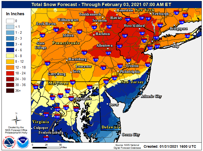
Just for completeness and comparison to previous runs, here are the 12Z models with no individual model commentary. They're basically quite similar to the 0Z suite, except for a few being more expansive with the snowfall shield, especially SW towards Philly and S towards the coast in SNJ (and for LI). I also included the latest regional NWS snowfall map to see what's being predicted, based somewhat on these models (plus many other things). We're in for a snowy (mostly) 36-42 hours for all of the Philly-NJ-NYC area, as per the NWS map, which looks pretty reasonable to me. After this it's radar and sky watching, with some shoveling and snow angels thrown in. Have fun, but stay safe.