
Funny you say that but one time me and some buddies hiked all the way to the top for a weekend of camping. Coincidentally it was the weekend we beat PSU in the 80s. We lugged coolers of beer, food and sleeping bags all the way up and it was brutal. To this day we refer to it as the trail of tears. Good time though once we made it upIt was really windy. It sounded so eerie. We were also the only people there it seemed. I must have said "Is this real life?" ten times. Lol
It's beautiful there no doubt about it. It just felt really long and as if no end was in sight. haha
Colleges
- American Athletic
- Atlantic Coast
- Big 12
- Big East
- Big Ten
- Colonial
- Conference USA
- Independents (FBS)
- Junior College
- Mountain West
- Northeast
- Pac-12
- Patriot League
- Pioneer League
- Southeastern
- Sun Belt
- Army
- Charlotte
- East Carolina
- Florida Atlantic
- Memphis
- Navy
- North Texas
- Rice
- South Florida
- Temple
- Tulane
- Tulsa
- UAB
- UTSA
- Boston College
- California
- Clemson
- Duke
- Florida State
- Georgia Tech
- Louisville
- Miami (FL)
- North Carolina
- North Carolina State
- Pittsburgh
- Southern Methodist
- Stanford
- Syracuse
- Virginia
- Virginia Tech
- Wake Forest
- Arizona
- Arizona State
- Baylor
- Brigham Young
- Cincinnati
- Colorado
- Houston
- Iowa State
- Kansas
- Kansas State
- Oklahoma State
- TCU
- Texas Tech
- UCF
- Utah
- West Virginia
- Illinois
- Indiana
- Iowa
- Maryland
- Michigan
- Michigan State
- Minnesota
- Nebraska
- Northwestern
- Ohio State
- Oregon
- Penn State
- Purdue
- Rutgers
- UCLA
- USC
- Washington
- Wisconsin
High Schools
- Illinois HS Sports
- Indiana HS Sports
- Iowa HS Sports
- Kansas HS Sports
- Michigan HS Sports
- Minnesota HS Sports
- Missouri HS Sports
- Nebraska HS Sports
- Oklahoma HS Sports
- Texas HS Hoops
- Texas HS Sports
- Wisconsin HS Sports
- Cincinnati HS Sports
- Delaware
- Maryland HS Sports
- New Jersey HS Hoops
- New Jersey HS Sports
- NYC HS Hoops
- Ohio HS Sports
- Pennsylvania HS Sports
- Virginia HS Sports
- West Virginia HS Sports
ADVERTISEMENT
You are using an out of date browser. It may not display this or other websites correctly.
You should upgrade or use an alternative browser.
You should upgrade or use an alternative browser.
OT: NJ Hiking Trails
- Thread starter Jm0513
- Start date

If you want a good hiking read check this out. The story is about my nephew and his future wife he met while hiking the pacific crest trail. I’m biased but it’s really good. His wife is the authorEverything a person wants PLUS really, really, really big spiders.
This was not an easy hike. Wind, rain, we somehow got off our trail and walked 4hrs straight. I fell flat on my face, I think I fractured my rib.
Lol
Amazon product ASIN 1530854067
Hartshorne park is a very good one but it’s in Highlands not Atlantic highlands.Hartshorne Park in Atlantic Highlands is a great place. Hike up to the top and there are ocean and NYC views.
Always liked Schooley Mtn Park in Morris, too.
Can't forget Hacklebarney.
Always merge the two into one. One of my favorite parts of NJ ...would have looked hard at living there if I'd stayed in the state.Hartshorne park is a very good one but it’s in Highlands not Atlantic highlands.
Always merge the two into one. One of my favorite parts of NJ ...would have looked hard at living there if I'd stayed in the state.
Had a friend that lived in Locust, back in the day. NEVER knew it was back there. Took a turn and came out near that building/hotel/condo on the top of the ridge (the one you see from Sandy Hook). I never would have known that whole area back in there unless we were friends, and I knew the shore pretty well. I said in an earlier post, you could end up lost for some time deep in the woods, there. Definitely a hidden gem of a spot.
After getting my second Pfizer vaccine, I finally resumed my AT hike and a few days ago completed the Smokies in five days, picking up a stretch of trail I missed pre-COVID. Anyway, I've now hiked from Springer Mountain GA to Damascus VA, some 470 miles. Taking some R&R time at home this week before resuming next week, starting in Damascus and trekking north.
Thanks. I'm DTS this weekend. Maybe I'll check one of these out.
DTS?Thanks. I'm DTS this weekend. Maybe I'll check one of these out.
I'm trying to come up with a three letter acronym the meaning of which translates roughly to: "calling up Mildone to go for a drive and have lunch somewhere nice". Alas, I cannot figure out a three letter acronym that works. 😥
Cue one of the vast legions that dislike me (and who could fault their judgement?) to suggest "DTS would have to equal Definitely Totally Stupid" which is what anybody would have to be to go for a drive and have lunch with me. Those legions are so mean, sometimes. 😀
D(Don't) T(Think) S(So)DTS?
I'm trying to come up with a three letter acronym the meaning of which translates roughly to: "calling up Mildone to go for a drive and have lunch somewhere nice". Alas, I cannot figure out a three letter acronym that works. 😥
Cue one of the vast legions that dislike me (and who could fault their judgement?) to suggest "DTS would have to equal Definitely Totally Stupid" which is what anybody would have to be to go for a drive and have lunch with me. Those legions are so mean, sometimes. 😀
Hahahahahah
DTS=down the shore
D(Don't) T(Think) S(So)
Hahahahahah
DTS=down the shore
Any trails in the woods around here would require hip waders after last weekend.
Aw man. And I'd have brought donuts to leave for your significant other and everything. 😉D(Don't) T(Think) S(So)
Hahahahahah
DTS=down the shore
Have fun at the beach. Gonna be pretty warm up here; might be cooler down there with ocean breezes.
DTS?
I'm trying to come up with a three letter acronym the meaning of which translates roughly to: "calling up Mildone to go for a drive and have lunch somewhere nice". Alas, I cannot figure out a three letter acronym that works. 😥
Cue one of the vast legions that dislike me (and who could fault their judgement?) to suggest "DTS would have to equal Definitely Totally Stupid" which is what anybody would have to be to go for a drive and have lunch with me. Those legions are so mean, sometimes. 😀
How about a 4-letter acronym?
MILF: Mildone Investigates Ladies 'n Food
No worries. I got away.I just got to Point..seems I may be hiking afterall..smh
AT update.... Last week, I hiked northward to Lickskillet Hollow in VA, Mile 604.9. Biggest mileage day was 26 into Damascus, VA, motivated by getting into town to avoid a T storm.
Typical day, though, is anywhere from 15 to 20 miles. It's really more about the time spent hiking vs distance on a given day. Tend to start early (7:30-ish) and hike until 4 or so. Full disclosure: I'm 62, so I'm not as ambitious as the younger hikers. If a bad-weather stretch is ahead, I'll hike in rain/snow, but I'll get off trail that night to dry out.
Full pack weight in warmer weather is around 28 lbs, about 5 more lbs in colder weather.
Anyway, will resume the northward trek next week. For those interested in long-distance hiking--the AT in particular--post any questions here, and I'll respond.
Lastly, the old Rutgers gang has been following along on my exploits. Seems I've piqued their interest, enough so that three want to join me in hiking the 73-miles of trail in NJ. Trying to plan that around the MSU homegame in early October.
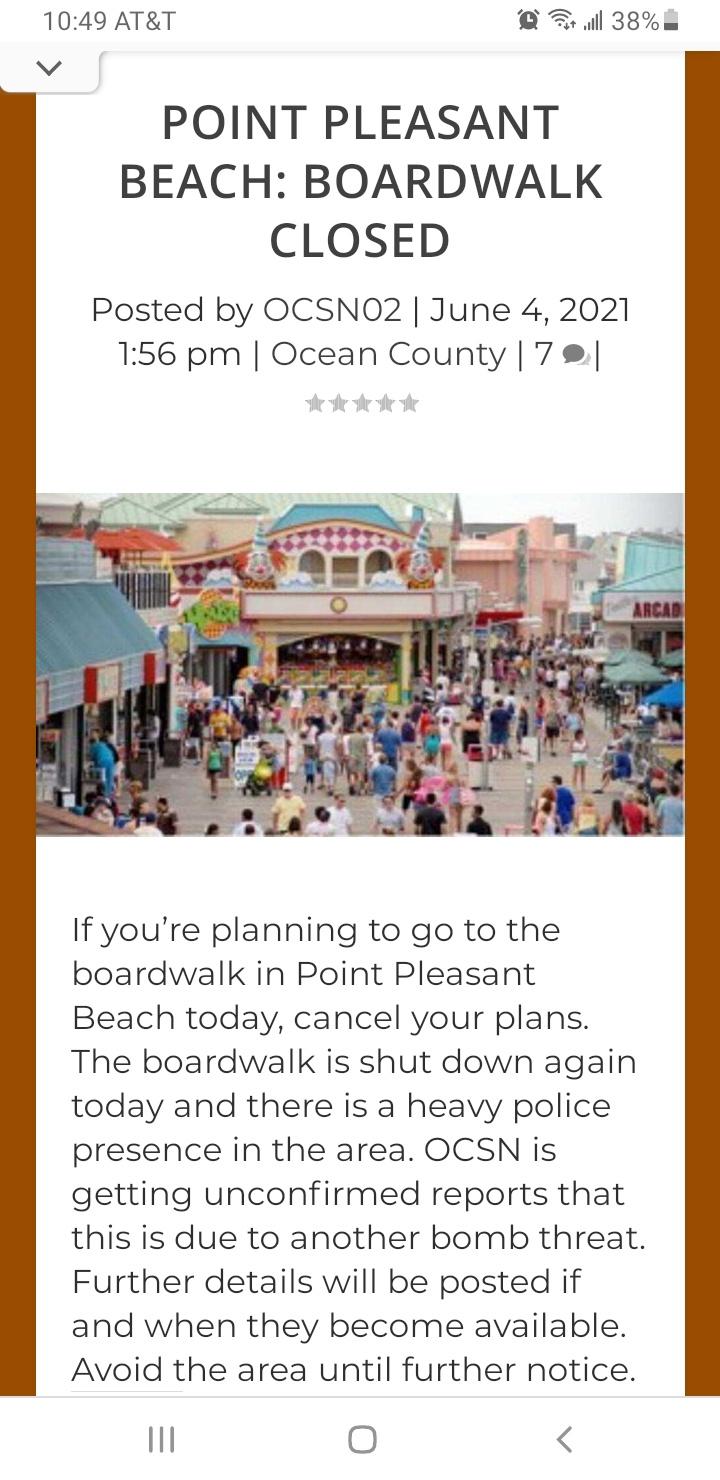
That's one empty beach. What happened?
I stood there for 5 seconds wondering is this real life? Did someone slip something in my Avocado Toast?? Could this beach really not have another human on it?That's one empty beach. What happened?
Nope...
Just a bomb scare!
Last edited:

South Mountain Reservation Is Home To A Fairy Trail In New Jersey
Explore a beautiful and enchanting fairy trail in New Jersey when you visit South Mountain Reservation! Kids and adults alike will love it.
Let me know when you get close to PA, I may be able to work some trail magic for you.AT update.... Last week, I hiked northward to Lickskillet Hollow in VA, Mile 604.9. Biggest mileage day was 26 into Damascus, VA, motivated by getting into town to avoid a T storm.
Typical day, though, is anywhere from 15 to 20 miles. It's really more about the time spent hiking vs distance on a given day. Tend to start early (7:30-ish) and hike until 4 or so. Full disclosure: I'm 62, so I'm not as ambitious as the younger hikers. If a bad-weather stretch is ahead, I'll hike in rain/snow, but I'll get off trail that night to dry out.
Full pack weight in warmer weather is around 28 lbs, about 5 more lbs in colder weather.
Anyway, will resume the northward trek next week. For those interested in long-distance hiking--the AT in particular--post any questions here, and I'll respond.
Lastly, the old Rutgers gang has been following along on my exploits. Seems I've piqued their interest, enough so that three want to join me in hiking the 73-miles of trail in NJ. Trying to plan that around the MSU homegame in early October.
You gonna clear the way with a tank?Let me know when you get close to PA, I may be able to work some trail magic for you.
Outdoors related—

 www.nj.com
Trooper, bicyclist save kayakers who fell overboard in Monmouth County waters
Two women were rescued Sunday after falling overboard into the water under the Glimmer Glass Drawbridge in Manasquan, authorities said.
You gonna clear the way with a tank?
Let me know when you get close to PA, I may be able to work some trail magic for you.
Thanks for your kind offer. I just got back home from a five-day AT section, now having covered the trail up to Mile 677.7 (northbound mileage), which is VA-42/Newport, Virginia. Portions of the trail there weave across the VA-WV state line.
Nice section, but the heat of summer is kicking in, and lots of blowdowns and overgrowth made it extra challenging. My last day (yesterday) covered 25 miles! And a 10-mile stretch of trail didn't have any water sources. In that situation, the best "trail magic" is a water and Gatorade cache. Electrolyte supplements are essential, for sure. Unfortunately, no trail magic at those road crossings yesterday.
My intent is to make my way up north, gradually, and eventually hike the whole trail. This summer I was looking at covering up to Harpers Ferry WV. We'll see. I've become a "fair weather" hiker, of late. While hiking in rain is ok for a day (especially a warm day), I'm not a fan of tenting a second consecutive night in rain. At that point, I retreat off trail to a motel to dry out. Thunderstorms are avoided at all costs. Nothing like being up on an exposed elevated ridge in lightning. So I look for a five-day fair-weather window when planning a section now.
PA, as you may know, is lovingly referred to by hikers as "Rocksylvania" as the northern section of the trail in PA is blanketed in rocks. Extra tough on the feet and ankles.
Yup, I am perhaps unfortunately very familiar with the Rocksylvania nickname. My offer of some trail magic still stands whether you get up into this area this year or next.Thanks for your kind offer. I just got back home from a five-day AT section, now having covered the trail up to Mile 677.7 (northbound mileage), which is VA-42/Newport, Virginia. Portions of the trail there weave across the VA-WV state line.
Nice section, but the heat of summer is kicking in, and lots of blowdowns and overgrowth made it extra challenging. My last day (yesterday) covered 25 miles! And a 10-mile stretch of trail didn't have any water sources. In that situation, the best "trail magic" is a water and Gatorade cache. Electrolyte supplements are essential, for sure. Unfortunately, no trail magic at those road crossings yesterday.
My intent is to make my way up north, gradually, and eventually hike the whole trail. This summer I was looking at covering up to Harpers Ferry WV. We'll see. I've become a "fair weather" hiker, of late. While hiking in rain is ok for a day (especially a warm day), I'm not a fan of tenting a second consecutive night in rain. At that point, I retreat off trail to a motel to dry out. Thunderstorms are avoided at all costs. Nothing like being up on an exposed elevated ridge in lightning. So I look for a five-day fair-weather window when planning a section now.
PA, as you may know, is lovingly referred to by hikers as "Rocksylvania" as the northern section of the trail in PA is blanketed in rocks. Extra tough on the feet and ankles.
I'm thinking some magic mushrooms?Yup, I am perhaps unfortunately very familiar with the Rocksylvania nickname. My offer of some trail magic still stands whether you get up into this area this year or next.
highest point in NJ
https://www.alltrails.com/parks/us/new-jersey/high-point-state-park
or maybe go North into NY to West Point.. see what the Dutch settlers and artists saw in the Hudson Valley.. when they painted what they saw, the folks back home didn't believe them.
https://www.alltrails.com/lists/new-york-near-west-point
I can't speak to hiking through High Point State Park. But it's a very beautiful area of NJ.highest point in NJ
https://www.alltrails.com/parks/us/new-jersey/high-point-state-park
or maybe go North into NY to West Point.. see what the Dutch settlers and artists saw in the Hudson Valley.. when they painted what they saw, the folks back home didn't believe them.
https://www.alltrails.com/lists/new-york-near-west-point
Driving through it, on Route 23, and continuing up through Port Jervis into NYS state along Route 97 (which curves alongside the Delaware River for awhile) can be a blast. Very scenic drive, with some cut-outs for parking. And great potential for, uh, enthusiastic driving, during low-traffic times.
A day spent hiking up in that area w/a good friend (I'm just sayin', @Jm0513, 😉), and then driving along those roads in a fun car could be a really fun day.
My boys are 9 and 11 and want to start some longer hikes. Scouts, love camping, etc. Can anyone recommend a 12-20 mile hike in NJ that will allow us to hike for a day, camp over night, then finish the next day?
I would assume the Appalachian Trail in the NW corner would be where you should start looking. But I would also assume.. given the population in NJ.. camping sites might be hard to come by re: bookings.My boys are 9 and 11 and want to start some longer hikes. Scouts, love camping, etc. Can anyone recommend a 12-20 mile hike in NJ that will allow us to hike for a day, camp over night, then finish the next day?
My boys are 9 and 11 and want to start some longer hikes. Scouts, love camping, etc. Can anyone recommend a 12-20 mile hike in NJ that will allow us to hike for a day, camp over night, then finish the next day?
You might want to check out entering the AT from a trailhead on the NY/NJ border, there’s a small parking lot across the street from a Greenwood Lake marina. Hike to Waywayanda, not sure how long it is, might not be long enough for what you are looking for but there’s camp sites and your boys can enjoy swimming/fishing the next day.
College student was in ICU from a bite from a Copperhead on a hike at Baldpate Mountain
 www.nj.com
Rare venomous snake bite on N.J. hike put college student in ICU. He’s now recovering at home.
Kevin Murray spent three days in the hospital after being bitten on the ankle by the venomous copperhead last week in Mercer County.
Jeez. Maybe I shouldn't be so hell-bent on moving into the mountains after all.College student was in ICU from a bite from a Copperhead on a hike at Baldpate Mountain
Rare venomous snake bite on N.J. hike put college student in ICU. He’s now recovering at home.
Kevin Murray spent three days in the hospital after being bitten on the ankle by the venomous copperhead last week in Mercer County.
If I read correctly, it seems the kid recovered okay even without requiring anti-venom. So that's good.
Jeez, used to trail-run there all the time.College student was in ICU from a bite from a Copperhead on a hike at Baldpate Mountain
Rare venomous snake bite on N.J. hike put college student in ICU. He’s now recovering at home.
Kevin Murray spent three days in the hospital after being bitten on the ankle by the venomous copperhead last week in Mercer County.
My first trip was as a scout in Pennsylvania (it was more difficult than it needed to be). If you are looking for a scout trip, it's tough to plan because a lot of places are limiting the size of groups to minimize impact (NY is a real pain in the neck). If you are not going with a group it opens up options. The AT is the easiest because unless there are restrictions, you can camp anywhere along it for the night. Most folks stay near the designated campsites/shelters and that is usually where you'll find water sources. It's not a bad idea to buy a good set of maps and a trail guide. My kid's first trips were along the AT in CT (near Bear Mt.). I haven't hiked between High Point and the NY border, but that's probably a good place to look for hikes. Pay attention to elevation as much as distance and keep the distance to a minimum for the first few trips. 7 or 8 miles with all your gear is good the first time out (that's when you'll figure out how much stuff you don't need). Good luck!My boys are 9 and 11 and want to start some longer hikes. Scouts, love camping, etc. Can anyone recommend a 12-20 mile hike in NJ that will allow us to hike for a day, camp over night, then finish the next day?
Last edited:
Let me tell you a story about two young boys, with a Tupperware container, trying to catch a Copperhead till their Mom came outside the Cabin. Those were not good times.College student was in ICU from a bite from a Copperhead on a hike at Baldpate Mountain
Rare venomous snake bite on N.J. hike put college student in ICU. He’s now recovering at home.
Kevin Murray spent three days in the hospital after being bitten on the ankle by the venomous copperhead last week in Mercer County.
Last edited:
Late to the thread- did you hike that day?I stood there for 5 seconds wondering is this real life? Did someone slip something in my Avocado Toast?? Could this beach really not have another human on it?
Nope...
Just a bomb scare!
There are some really great hiking trails in Allaire State Park. Main trailhead is on Hospital Road, but it can be busy with Mountain Bikers. On the other side of the main parking lot, there is a trail that leads to the dinosaurs--that may have been covered in this thread. There are also some decent trails across from the historic part of Allaire State Park on Atlantic Ave that loop around the old Brisbane Child Treatment Center.
Out near the disc golf course and campground on Atlantic Ave, there are some trails that lead to an old stone and railroad tie bridge over a creek.
College student was in ICU from a bite from a Copperhead on a hike at Baldpate Mountain
Rare venomous snake bite on N.J. hike put college student in ICU. He’s now recovering at home.
Kevin Murray spent three days in the hospital after being bitten on the ankle by the venomous copperhead last week in Mercer County.
Nasty.
Been a lot of snakes down on trails because of drought. Not nearly as many rattlers as last year, but a lot of gopher snakes that have a very similar color pattern - only more rectangular than diamond (which you can't make out from afar). Nearly had a heart attack when I ran right on top of one with my bike because I couldn't stop in time. Huge sigh of relief when it slithered into the brush without an ear-piercing rattle and I eyed the squares and no rattle tail.
. On the other side of the main parking lot, there is a trail that leads to the dinosaurs--that may have been covered in this thread.
No it wasn’t covered in this thread. I tagged you but you decided to blow me off. O and My God was it hot out there today. I decided to call it quits before someone keeled over and died. Mainly me.
Similar threads
- Replies
- 42
- Views
- 2K
OT: Minor to Moderate (2-4?) Snowfall Likely Sat morning (2/17); will be <32F, so expect slick roads
- Replies
- 213
- Views
- 8K
- Replies
- 592
- Views
- 22K
- Replies
- 608
- Views
- 21K
- Replies
- 125
- Views
- 4K
ADVERTISEMENT
ADVERTISEMENT