I predict less than an inch of rain for most of the State.
A typical summer day or two.
Nothing to see here
A typical summer day or two.
Nothing to see here


Follow along with the video below to see how to install our site as a web app on your home screen.
Note: This feature may not be available in some browsers.
Is he not aware that cyclones don't form over the Atlantic? Isn't this common knowledge?
Still not convinced it's thread worthy, lol. An inch or two of rain with minimal other impacts isn't usually noteworthy, although there is still potential for 2-4" of rain, which would be noteworthy.
Yeah, but look what happened in the t-storm thread when I merely made a post suggesting the possibility of a tropical storm forming and moving much closer to the coast - which is what actually is occurring, even though that was a low probability a few days ago, but obviously possible. The bash brothers do that all the time and it gets old.I’m trying to be nice...
We would rather you start it than somebody else. :Wink:
I think he's being funny or trying to. Generally, a cyclone is any low pressure system anywhere, but more formally, named tropical systems in the Indian Ocean area (and southern hemisphere) are called "cyclones." As per the map.Huh?
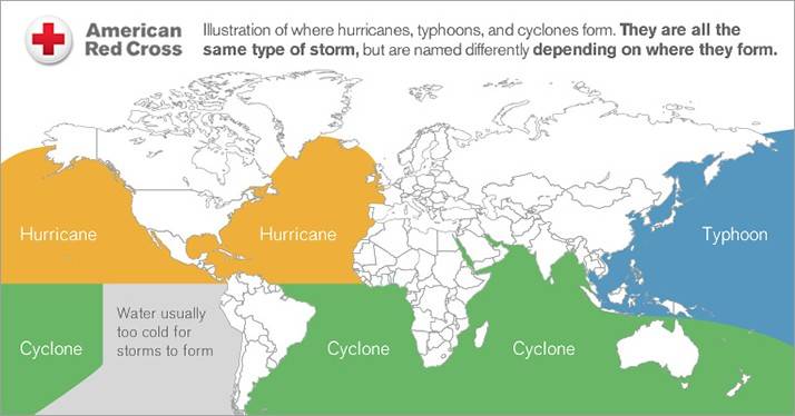
I think he's being funny or trying to. Generally, a cyclone is any low pressure system anywhere, but more formally, named tropical systems in the Indian Ocean area (and southern hemisphere) are called "cyclones." As per the map.
Still not convinced it's thread worthy, lol. An inch or two of rain with minimal other impacts isn't usually noteworthy, although there is still potential for 2-4" of rain, which would be noteworthy.
I’m trying to be nice...
We would rather you start it than somebody else. :Wink:
Thank goodness we have a pro in this thread. This thread was amateur hour before you got here!That map is not particularly helpful, as this is not a typical tropical system and those are mostly tropical models. The global and mesoscale models are the ones to watch here and unfortunately, they're all over the place right now with track and intensity, including the 12Z models coming out now. GFS is a serious rainstorm (2-3"), while the NAM and CMC are modest storms with <1/2" for most, except along the coast with more. Pros are going to have a very tough forecast to make with such model variability.
Tropical Storm Warning posted, just now. Just got the alert.

Sorry, my friend, it's really looking like a washout all day tomorrow. Every model is now showing at least 1" for the 95 corridor, with most showing 1-3", although a couple are showing a sharp cutoff, not too far west of the TPK, which means there is still some small possibility that enough of a shift east will occur between now and tomorrow to greatly reduce the amount of rain for NB, but that's looking much less likely than this morning. The other dim hope is that the system speeds up a little, as one model shows, with the rain being mostly over by 5-6 pm. Again low probability, but keep an eye on it.doesn’t sound promising. I’ll check here for an update after tonight’s runs. :).
Maybe we should have an outdoor dining weather report?
Didn't @bac2therac shame you in the other thread for suggesting the possibility of this much rain?Yep, just checked 2 minutes ago and no update. Hmmmm, key messages say 3-5" and up to 8" locally. NWS still only calling for 1-3", which I think makes sense looking at the models, but the coast especially could be in for some serious rain and the NHC is looking at a few of the tropical models which are showing 3-5" of rain.
https://www.nhc.noaa.gov/graphics_at1.shtml?start#contents
Key Messages:
1. Fay is expected to produce 3 to 5 inches of rain with isolated
totals of 8 inches along and near the track across the mid-Atlantic
states into southeast New York and southern New England. These rains
may result in flash flooding where the heaviest amounts occur.
Widespread river flooding is not expected at this time.
2. Tropical storm conditionsare expected along portions of the
mid-Atlantic and northeast coast Friday and Friday night, and a
Tropical Storm Warning has been issued for the coasts of New Jersey,
New York and Connecticut, including Long Island.
FORECAST POSITIONS AND MAX WINDS
INIT 09/2100Z 35.5N 74.9W 40 KT 45 MPH
12H 10/0600Z 37.1N 74.7W 45 KT 50 MPH
24H 10/1800Z 39.0N 74.3W 45 KT 50 MPH
36H 11/0600Z 41.6N 73.6W 35 KT 40 MPH...INLAND
48H 11/1800Z 45.3N 72.4W 25 KT 30 MPH...INLAND
60H 12/0600Z 49.1N 70.3W 20 KT 25 MPH...POST-TROP/EXTRATROP
72H 12/1800Z...DISSIPATED
And here's the NWS discussion...
Area Forecast Discussion
National Weather Service Mount Holly NJ
326 PM EDT Thu Jul 9 2020
SHORT TERM /6 PM THIS EVENING THROUGH FRIDAY NIGHT/...
The low is forecast to work its way up the coasts of Delaware and
New Jersey on Friday, before moving into New England on Friday night.
Rain showers and scattered thunderstorms are expected for Friday.
The rain will be heavy at times. Rainfall totals of 1 to 3 inches
should be common in our region with locally higher amounts possible
based on the nature of the system.
The back edge of the heavy rain is anticipated to lift gradually
northward across our region during the afternoon and evening hours.
The chance of showers will likely decrease on Friday night.
The wind is expected to favor the northeast on Friday at speeds of
10 to 20 MPH with gusts near 30 MPH near the coast, and around 10
MPH inland. The wind should become light and variable on Friday
night.
Highs on Friday are forecast to be in the upper 70s and lower 80s.
Lows on Friday night should favor the upper 60s and lower 70s.
This storm will be long gone, but still could be some summer t-storms, with no rain in some spots and 1/4" or more in others - where is impossible to predict...I have an outdoor gathering scheduled for 3 PM Saturday in Morris County ……… should I stick with it or reschedule to Sunday ?
Sorry, my friend, it's really looking like a washout all day tomorrow. Every model is now showing at least 1" for the 95 corridor, with most showing 1-3", although a couple are showing a sharp cutoff, not too far west of the TPK, which means there is still some small possibility that enough of a shift east will occur between now and tomorrow to greatly reduce the amount of rain for NB, but that's looking much less likely than this morning. The other dim hope is that the system speeds up a little, as one model shows, with the rain being mostly over by 5-6 pm. Again low probability, but keep an eye on it.
Sorry, my friend, it's really looking like a washout all day tomorrow. Every model is now showing at least 1" for the 95 corridor, with most showing 1-3", although a couple are showing a sharp cutoff, not too far west of the TPK, which means there is still some small possibility that enough of a shift east will occur between now and tomorrow to greatly reduce the amount of rain for NB, but that's looking much less likely than this morning. The other dim hope is that the system speeds up a little, as one model shows, with the rain being mostly over by 5-6 pm. Again low probability, but keep an eye on it.
Now looking worse for rainfall, if the latest model runs (pretty strong consensus - see my last post) are correct, as nor'easters are generally cold core storms with less energy than tropical systems, which are warm core systems (deriving energy from the warm waters of the ocean) - less energy means less potential rainfall usually. This storm isn't looking hellacious for winds and coastal flooding, but we're now likely to see flooding rains in urban areas and probably some streams and rivers. Going to be watching my roof and basement closely, lol.Same, better or worse than typical nor'easter?
Didn't @bac2therac shame you in the other thread for suggesting the possibility of this much rain?
A public apology is in order.
Yes, the Brothers Grim did their usual number. As I said in the other thread, the big, big rains might not verify, but the storm becoming tropical and the track shifting 100-200 miles west of the Monday forecast occurred and all I ever said was that that was possible back on Monday (but unlikely, although it needed to be watched carefully). I've never cared about being challenged, as I'll argue just about anything, but I just dislike the over-the-top snark.
https://rutgers.forums.rivals.com/t...orms-today-in-central-nj.198991/#post-4628424

Explanation: XFinity=Comcast=Horrific.Getting HAMMERED here in OC right now with heavy rain and wind. Can someone explain to me why my cable TV keeps going out? I had DirecTV for the last 10 years and hardly ever had a problem but just switched to Xfinity a month ago when DTV raised my rate by almost $75 per month.
Explanation: XFinity=Comcast=Horrific.
You only live once. Take it to the Xtreme brother!Was planning on tubing the Delaware water gap tomorrow. I'm guessing the water levels will be dangerous. Anyone live up that way have any insight? We usually launch from Frenchtown
May be a function of location too. We have had FIOS in two Monmouth county towns, and it has been flawless. Comcast was terrible.All cable companies suck. I’ve been without Verizon Fios service since Monday because of the storm. A tech was supposed to show up yesterday never showed. Getting to talk to a person there is a nightmare.
Was planning on tubing the Delaware water gap tomorrow. I'm guessing the water levels will be dangerous. Anyone live up that way have any insight? We usually launch from Frenchtown
My neighbor drives the rescue boat on the river in Lambertville. He will be called out a good 8-10 times this weekend I’m sure.Was planning on tubing the Delaware water gap tomorrow. I'm guessing the water levels will be dangerous. Anyone live up that way have any insight? We usually launch from Frenchtown
A friend would like to know if the bash brothers are Bac and T2K?Yeah, but look what happened in the t-storm thread when I merely made a post suggesting the possibility of a tropical storm forming and moving much closer to the coast - which is what actually is occurring, even though that was a low probability a few days ago, but obviously possible. The bash brothers do that all the time and it gets old.
My neighbor drives the rescue boat on the river in Lambertville. He will be called out a good 8-10 times this weekend I’m sure.
And you will be wrong.I don't see Sussex, Warren, Morris getting much effect of rain from this.
100% dry so far
And you will be wrong.


