Yes it is now and for the last 1/2 hour or so, we'll see how much accumulates. This to me is the last hurrah if it doesn't gather now, it won't. Footprints on that 3/4 of an inch from getting the mail still haven't even fully filled in yet.Coming down heavy in South Brunswick.


Colleges
- American Athletic
- Atlantic Coast
- Big 12
- Big East
- Big Ten
- Colonial
- Conference USA
- Independents (FBS)
- Junior College
- Mountain West
- Northeast
- Pac-12
- Patriot League
- Pioneer League
- Southeastern
- Sun Belt
- Army
- Charlotte
- East Carolina
- Florida Atlantic
- Memphis
- Navy
- North Texas
- Rice
- South Florida
- Temple
- Tulane
- Tulsa
- UAB
- UTSA
- Boston College
- California
- Clemson
- Duke
- Florida State
- Georgia Tech
- Louisville
- Miami (FL)
- North Carolina
- North Carolina State
- Pittsburgh
- Southern Methodist
- Stanford
- Syracuse
- Virginia
- Virginia Tech
- Wake Forest
- Arizona
- Arizona State
- Baylor
- Brigham Young
- Cincinnati
- Colorado
- Houston
- Iowa State
- Kansas
- Kansas State
- Oklahoma State
- TCU
- Texas Tech
- UCF
- Utah
- West Virginia
- Illinois
- Indiana
- Iowa
- Maryland
- Michigan
- Michigan State
- Minnesota
- Nebraska
- Northwestern
- Ohio State
- Oregon
- Penn State
- Purdue
- Rutgers
- UCLA
- USC
- Washington
- Wisconsin
High School
- Illinois HS Sports
- Indiana HS Sports
- Iowa HS Sports
- Kansas HS Sports
- Michigan HS Sports
- Minnesota HS Sports
- Missouri HS Sports
- Nebraska HS Sports
- Oklahoma HS Sports
- Texas HS Hoops
- Texas HS Sports
- Wisconsin HS Sports
- Cincinnati HS Sports
- Delaware
- Maryland HS Sports
- New Jersey HS Hoops
- New Jersey HS Sports
- NYC HS Hoops
- Ohio HS Sports
- Pennsylvania HS Sports
- Virginia HS Sports
- West Virginia HS Sports
ADVERTISEMENT
Install the app
How to install the app on iOS
Follow along with the video below to see how to install our site as a web app on your home screen.
Note: This feature may not be available in some browsers.
You are using an out of date browser. It may not display this or other websites correctly.
You should upgrade or use an alternative browser.
You should upgrade or use an alternative browser.
OT: Potential Winter Storm on 3/7-8
- Thread starter RU848789
- Start date

weather report says till 6 but the radar says what you are seeing IMHO...Looks like the back edge is approaching fast to Philly and here in Washington Crossing. Is this almost over here? Please say yes :pray:
I just lost a 6 year old Weeping Willow I have been babying and was turning into a backyard feature..FRACK! (or should I say crack. Right in half!)..and right after I did the front walk with the blower I turned around to see a somewhat large branch right where I finished. Didn't even hear the thing come down.
How much longer are we getting the heavy bands for?for those not getting it whether you are to the northeast toward NYC or southeast toward the shore...you will soon enough..the heaviest bands are going to pivot your way. I have been getting raked the past 90 minutes and that band looks like it is pivoting and combining with band of shore that will slide from southwest to northeast.
http://weather.cod.edu/satrad/nexrad/index.php?type=DIX-N0Q-1-48
Well good thing it didn't come down on you. :)weather report says till 6 but the radar says what you are seeing IMHO...
I just lost a 6 year old Weeping Willow I have been babying and was turning into a backyard feature..FRACK! (or should I say crack. Right in half!)..and right after I did the front walk with the blower I turned around to see a somewhat large branch right where I finished. Didn't even hear the thing come down.
Great job in this thread! Very concise and actionable info you are providing.you can see the pivot movement...somerset county was ripping for almost 2 hours but now that seems to have slid southward and now creating a death band in southwestern jersey that is going to pinwheel

weather report says till 6 but the radar says what you are seeing IMHO...
I just lost a 6 year old Weeping Willow I have been babying and was turning into a backyard feature..FRACK! (or should I say crack. Right in half!)..and right after I did the front walk with the blower I turned around to see a somewhat large branch right where I finished. Didn't even hear the thing come down.
Did the trunk split down the middle? We had the same happen to a Japanese maple some years ago. We wrapped rope around the trunk to hold it together, and the tree mended itself, and we cut the rope loose some months later. It's 20' tall now.
How much longer are we getting the heavy bands for?
probably two more hours of accumulating snows for us at least but I would imagine the worst for us was probably 2-330PM...that will not be true for those to the east of us
I've also read about the pam cooking spray but I use WD40 silicone spray I don't think it gets shot over everything, it's just a coating and I wipe it down. There's no way to know I even used it if you looked.Pam cooking spray. You don't want to shoot WD-40 all over your lawn or street.
Fresh updates to all the warnings and advisories from NWS-Philly. Still calling for an additional 5-8" for the 95 corridor from Philly to Newark. Updated warnings for NWS-NYC are down below.
URGENT - WINTER WEATHER MESSAGE
National Weather Service Mount Holly NJ
329 PM EST Wed Mar 7 2018
A compact but powerful nor`easter will skirt the New Jersey
coast this afternoon before heading toward Cape Cod this evening.
It will produce periods of heavy precipitation. All locations
along and west of the Interstate 95 corridor are vulnerable to
heavy snow, with the greatest uncertainty within 20 miles east of
Interstate 95. Otherwise, there is very high confidence that this
storm will make travel difficult or nearly impossible at times
late this morning and this afternoon across much of eastern
Pennsylvania and northern New Jersey, basically from near
Philadelphia, west and north to the New York state border and
beyond. Highest snow accumulations will be in the hilly areas.
Unnecessary travel is not recommended today. Thereafter,
communities will need tonight and Thursday morning to dig out.
Caution is advised for those with heart problems as over exertion
removing wet snow could prompt a heart attack.
Middlesex-Mercer-Eastern Chester-Eastern Montgomery-Lower Bucks-
Including the cities of New Brunswick, Trenton, West Chester,
Kennett Square, Norristown, Lansdale, Morrisville, and Doylestown
329 PM EST Wed Mar 7 2018
...WINTER STORM WARNING REMAINS IN EFFECT UNTIL 3 AM EST
THURSDAY...
* WHAT...Heavy snow. Additional snow accumulations of 5 to 8
inches are expected.
New Castle-Western Monmouth-Salem-Gloucester-Camden-
Northwestern Burlington-
Including the cities of Wilmington, Freehold, Pennsville,
Glassboro, Camden, Cherry Hill, Moorestown, and Mount Holly
329 PM EST Wed Mar 7 2018
...WINTER STORM WARNING REMAINS IN EFFECT UNTIL 3 AM EST
THURSDAY...
* WHAT...Heavy snow. Additional snow accumulations of 3 to 5
inches are expected.
Warren-Morris-Hunterdon-Somerset-Berks-Lehigh-Northampton-
Western Chester-Western Montgomery-Upper Bucks-
Including the cities of Washington, Morristown, Flemington,
Somerville, Reading, Allentown, Bethlehem, Easton, Honey Brook,
Oxford, Collegeville, Pottstown, Chalfont, and Perkasie
329 PM EST Wed Mar 7 2018
...WINTER STORM WARNING REMAINS IN EFFECT UNTIL 3 AM EST
THURSDAY...
* WHAT...Heavy snow. Additional snow accumulations of 4 to 7
inches are expected.
Sussex-Carbon-Monroe-
Including the cities of Newton, Jim Thorpe, and Stroudsburg
329 PM EST Wed Mar 7 2018
...WINTER STORM WARNING REMAINS IN EFFECT UNTIL 3 AM EST
THURSDAY...
* WHAT...Heavy snow. Additional snow accumulations of 3 to 6
inches, with localized amounts up to 8 inches, are expected.
Delaware-Philadelphia-
Including the cities of Media and Philadelphia
329 PM EST Wed Mar 7 2018
...WINTER STORM WARNING REMAINS IN EFFECT UNTIL 3 AM EST
THURSDAY...
* WHAT...Heavy snow. Additional snow accumulations of 5 to 8
inches are expected.
* WHERE...Delaware and Philadelphia counties.
Edit - updated warnings for NWS-NYC. Reduced amounts a bit vs. earlier, since they haven't gotten much in the City.
URGENT - WINTER WEATHER MESSAGE
National Weather Service New York NY
340 PM EST Wed Mar 7 2018
URGENT - WINTER WEATHER MESSAGE
National Weather Service New York NY
340 PM EST Wed Mar 7 2018
Richmond (Staten Island)-Kings (Brooklyn)-Northwestern Suffolk-
Southwestern Suffolk-Southern Queens-Southern Nassau-
340 PM EST Wed Mar 7 2018
...WINTER STORM WARNING REMAINS IN EFFECT UNTIL 4 AM EST
THURSDAY...
* WHAT...Heavy snow. Total snow accumulations of 5 to 9 inches
are expected, highest amounts for northern and western sections.
Snowfall rates of 1 to 3 inches per hour expected into this
evening.
URGENT - WINTER WEATHER MESSAGE
National Weather Service New York NY
340 PM EST Wed Mar 7 2018
Hudson-Southern Westchester-New York (Manhattan)-Bronx-
Northern Queens-Northern Nassau-
340 PM EST Wed Mar 7 2018
...WINTER STORM WARNING REMAINS IN EFFECT UNTIL 4 AM EST
THURSDAY...
* WHAT...Heavy snow. Total snow accumulations of 7 to 11 inches
are expected. Snowfall rates of 1 to 3 inches per hour expected
into this evening.
URGENT - WINTER WEATHER MESSAGE
National Weather Service New York NY
340 PM EST Wed Mar 7 2018
Western Passaic-Eastern Passaic-Western Bergen-Western Essex-
Orange-Putnam-Rockland-Northern Westchester-
340 PM EST Wed Mar 7 2018
...WINTER STORM WARNING REMAINS IN EFFECT UNTIL 4 AM EST
THURSDAY...
* WHAT...Heavy snow. Total snow accumulations of 12 to 20 inches
are expected, highest amounts across higher elevations. Snowfall
rates of 1 to 3 inches per hour expected into early this
evening.
URGENT - WINTER WEATHER MESSAGE
National Weather Service New York NY
340 PM EST Wed Mar 7 2018
Eastern Bergen-Eastern Essex-Western Union-Eastern Union-
340 PM EST Wed Mar 7 2018
...WINTER STORM WARNING REMAINS IN EFFECT UNTIL 4 AM EST
THURSDAY...
* WHAT...Heavy snow. Total snow accumulations of 7 to 14 inches
are expected. Snowfall rates of 1 to 3 inches per hour expected
into early this evening.
URGENT - WINTER WEATHER MESSAGE
National Weather Service Mount Holly NJ
329 PM EST Wed Mar 7 2018
A compact but powerful nor`easter will skirt the New Jersey
coast this afternoon before heading toward Cape Cod this evening.
It will produce periods of heavy precipitation. All locations
along and west of the Interstate 95 corridor are vulnerable to
heavy snow, with the greatest uncertainty within 20 miles east of
Interstate 95. Otherwise, there is very high confidence that this
storm will make travel difficult or nearly impossible at times
late this morning and this afternoon across much of eastern
Pennsylvania and northern New Jersey, basically from near
Philadelphia, west and north to the New York state border and
beyond. Highest snow accumulations will be in the hilly areas.
Unnecessary travel is not recommended today. Thereafter,
communities will need tonight and Thursday morning to dig out.
Caution is advised for those with heart problems as over exertion
removing wet snow could prompt a heart attack.
Middlesex-Mercer-Eastern Chester-Eastern Montgomery-Lower Bucks-
Including the cities of New Brunswick, Trenton, West Chester,
Kennett Square, Norristown, Lansdale, Morrisville, and Doylestown
329 PM EST Wed Mar 7 2018
...WINTER STORM WARNING REMAINS IN EFFECT UNTIL 3 AM EST
THURSDAY...
* WHAT...Heavy snow. Additional snow accumulations of 5 to 8
inches are expected.
New Castle-Western Monmouth-Salem-Gloucester-Camden-
Northwestern Burlington-
Including the cities of Wilmington, Freehold, Pennsville,
Glassboro, Camden, Cherry Hill, Moorestown, and Mount Holly
329 PM EST Wed Mar 7 2018
...WINTER STORM WARNING REMAINS IN EFFECT UNTIL 3 AM EST
THURSDAY...
* WHAT...Heavy snow. Additional snow accumulations of 3 to 5
inches are expected.
Warren-Morris-Hunterdon-Somerset-Berks-Lehigh-Northampton-
Western Chester-Western Montgomery-Upper Bucks-
Including the cities of Washington, Morristown, Flemington,
Somerville, Reading, Allentown, Bethlehem, Easton, Honey Brook,
Oxford, Collegeville, Pottstown, Chalfont, and Perkasie
329 PM EST Wed Mar 7 2018
...WINTER STORM WARNING REMAINS IN EFFECT UNTIL 3 AM EST
THURSDAY...
* WHAT...Heavy snow. Additional snow accumulations of 4 to 7
inches are expected.
Sussex-Carbon-Monroe-
Including the cities of Newton, Jim Thorpe, and Stroudsburg
329 PM EST Wed Mar 7 2018
...WINTER STORM WARNING REMAINS IN EFFECT UNTIL 3 AM EST
THURSDAY...
* WHAT...Heavy snow. Additional snow accumulations of 3 to 6
inches, with localized amounts up to 8 inches, are expected.
Delaware-Philadelphia-
Including the cities of Media and Philadelphia
329 PM EST Wed Mar 7 2018
...WINTER STORM WARNING REMAINS IN EFFECT UNTIL 3 AM EST
THURSDAY...
* WHAT...Heavy snow. Additional snow accumulations of 5 to 8
inches are expected.
* WHERE...Delaware and Philadelphia counties.
Edit - updated warnings for NWS-NYC. Reduced amounts a bit vs. earlier, since they haven't gotten much in the City.
URGENT - WINTER WEATHER MESSAGE
National Weather Service New York NY
340 PM EST Wed Mar 7 2018
URGENT - WINTER WEATHER MESSAGE
National Weather Service New York NY
340 PM EST Wed Mar 7 2018
Richmond (Staten Island)-Kings (Brooklyn)-Northwestern Suffolk-
Southwestern Suffolk-Southern Queens-Southern Nassau-
340 PM EST Wed Mar 7 2018
...WINTER STORM WARNING REMAINS IN EFFECT UNTIL 4 AM EST
THURSDAY...
* WHAT...Heavy snow. Total snow accumulations of 5 to 9 inches
are expected, highest amounts for northern and western sections.
Snowfall rates of 1 to 3 inches per hour expected into this
evening.
URGENT - WINTER WEATHER MESSAGE
National Weather Service New York NY
340 PM EST Wed Mar 7 2018
Hudson-Southern Westchester-New York (Manhattan)-Bronx-
Northern Queens-Northern Nassau-
340 PM EST Wed Mar 7 2018
...WINTER STORM WARNING REMAINS IN EFFECT UNTIL 4 AM EST
THURSDAY...
* WHAT...Heavy snow. Total snow accumulations of 7 to 11 inches
are expected. Snowfall rates of 1 to 3 inches per hour expected
into this evening.
URGENT - WINTER WEATHER MESSAGE
National Weather Service New York NY
340 PM EST Wed Mar 7 2018
Western Passaic-Eastern Passaic-Western Bergen-Western Essex-
Orange-Putnam-Rockland-Northern Westchester-
340 PM EST Wed Mar 7 2018
...WINTER STORM WARNING REMAINS IN EFFECT UNTIL 4 AM EST
THURSDAY...
* WHAT...Heavy snow. Total snow accumulations of 12 to 20 inches
are expected, highest amounts across higher elevations. Snowfall
rates of 1 to 3 inches per hour expected into early this
evening.
URGENT - WINTER WEATHER MESSAGE
National Weather Service New York NY
340 PM EST Wed Mar 7 2018
Eastern Bergen-Eastern Essex-Western Union-Eastern Union-
340 PM EST Wed Mar 7 2018
...WINTER STORM WARNING REMAINS IN EFFECT UNTIL 4 AM EST
THURSDAY...
* WHAT...Heavy snow. Total snow accumulations of 7 to 14 inches
are expected. Snowfall rates of 1 to 3 inches per hour expected
into early this evening.
Last edited:
Overall this thing underperformed.
for some it did, for some it delivered, verdict will be what it does in NE NJ, North Jersey coast and NYC
Fresh updates to all the warnings and advisories from NWS-Philly. Still calling for an additional 5-8" for the 95 corridor from Philly to Newark:
RGENT - WINTER WEATHER MESSAGE
National Weather Service Mount Holly NJ
329 PM EST Wed Mar 7 2018
A compact but powerful nor`easter will skirt the New Jersey
coast this afternoon before heading toward Cape Cod this evening.
It will produce periods of heavy precipitation. All locations
along and west of the Interstate 95 corridor are vulnerable to
heavy snow, with the greatest uncertainty within 20 miles east of
Interstate 95. Otherwise, there is very high confidence that this
storm will make travel difficult or nearly impossible at times
late this morning and this afternoon across much of eastern
Pennsylvania and northern New Jersey, basically from near
Philadelphia, west and north to the New York state border and
beyond. Highest snow accumulations will be in the hilly areas.
Unnecessary travel is not recommended today. Thereafter,
communities will need tonight and Thursday morning to dig out.
Caution is advised for those with heart problems as over exertion
removing wet snow could prompt a heart attack.
Middlesex-Mercer-Eastern Chester-Eastern Montgomery-Lower Bucks-
Including the cities of New Brunswick, Trenton, West Chester,
Kennett Square, Norristown, Lansdale, Morrisville, and Doylestown
329 PM EST Wed Mar 7 2018
...WINTER STORM WARNING REMAINS IN EFFECT UNTIL 3 AM EST
THURSDAY...
* WHAT...Heavy snow. Additional snow accumulations of 5 to 8
inches are expected.
New Castle-Western Monmouth-Salem-Gloucester-Camden-
Northwestern Burlington-
Including the cities of Wilmington, Freehold, Pennsville,
Glassboro, Camden, Cherry Hill, Moorestown, and Mount Holly
329 PM EST Wed Mar 7 2018
...WINTER STORM WARNING REMAINS IN EFFECT UNTIL 3 AM EST
THURSDAY...
* WHAT...Heavy snow. Additional snow accumulations of 3 to 5
inches are expected.
Warren-Morris-Hunterdon-Somerset-Berks-Lehigh-Northampton-
Western Chester-Western Montgomery-Upper Bucks-
Including the cities of Washington, Morristown, Flemington,
Somerville, Reading, Allentown, Bethlehem, Easton, Honey Brook,
Oxford, Collegeville, Pottstown, Chalfont, and Perkasie
329 PM EST Wed Mar 7 2018
...WINTER STORM WARNING REMAINS IN EFFECT UNTIL 3 AM EST
THURSDAY...
* WHAT...Heavy snow. Additional snow accumulations of 4 to 7
inches are expected.
Sussex-Carbon-Monroe-
Including the cities of Newton, Jim Thorpe, and Stroudsburg
329 PM EST Wed Mar 7 2018
...WINTER STORM WARNING REMAINS IN EFFECT UNTIL 3 AM EST
THURSDAY...
* WHAT...Heavy snow. Additional snow accumulations of 3 to 6
inches, with localized amounts up to 8 inches, are expected.
Delaware-Philadelphia-
Including the cities of Media and Philadelphia
329 PM EST Wed Mar 7 2018
...WINTER STORM WARNING REMAINS IN EFFECT UNTIL 3 AM EST
THURSDAY...
* WHAT...Heavy snow. Additional snow accumulations of 5 to 8
inches are expected.
* WHERE...Delaware and Philadelphia counties.
Additional 5-8 inches from Philly to Newark? Are you sure that's not an update from 6 hours ago?
This thing is wrapping up in Philly as we speak.
I'd say it did pretty good job here in Ringoes...still pounding. and as I am posting this a tree large branch just came down and took out the canopy frame on my back deck....oh boy. getting bad.Overall this thing underperformed.

Fresh updates to all the warnings and advisories from NWS-Philly. Still calling for an additional 5-8" for the 95 corridor from Philly to Newark:
Not gonna happen. As I said, I'm out in King of Prussia and it's done here. Philly will see its last flakes in under an hour.
weather report says till 6 but the radar says what you are seeing IMHO...
I just lost a 6 year old Weeping Willow I have been babying and was turning into a backyard feature..FRACK! (or should I say crack. Right in half!)..and right after I did the front walk with the blower I turned around to see a somewhat large branch right where I finished. Didn't even hear the thing come down.
I lost two WW both over 30’ tall. The first was the ‘98 Labor Day derecho that bac alluded to earlier in the thread
Planted another in the same area a year later and lost it during Sandy. No more WW for me. I have a Norway Spuce growing there now.
snapped in half like a right angle. 30 mins earlier I pointed it out to the wife and said when I am out there I will go give it a shake. Never had the chance.Did the trunk split down the middle? We had the same happen to a Japanese maple some years ago. We wrapped rope around the trunk to hold it together, and the tree mended itself, and we cut the rope loose some months later. It's 20' tall now.
yeah the NWS seems a bit cuckoo with those amounts in some places...how are some of those PA counties getting 3-5 more and 5-8...if I am approaching 6 in somerset county now how am i getting up to 7 more?
I think the threat of this is running from just east of Philly...95 is in the game here thats for sure, Middlesex, Monmouth, Ocean and up to Union, Newark, NYC, Staten Island
but I think for the counties like Hunterdon, Somerset and into the Lehigh Valley those numbers look wacko
I think the threat of this is running from just east of Philly...95 is in the game here thats for sure, Middlesex, Monmouth, Ocean and up to Union, Newark, NYC, Staten Island
but I think for the counties like Hunterdon, Somerset and into the Lehigh Valley those numbers look wacko
+1yeah the NWS seems a bit cuckoo with those amounts in some places...how are some of those PA counties getting 3-5 more and 5-8...if I am approaching 6 in somerset county now how am i getting up to 7 more?
I think the threat of this is running from just east of Philly...95 is in the game here thats for sure, Middlesex, Monmouth, Ocean and up to Union, Newark, NYC, Staten Island
but I think for the counties like Hunterdon, Somerset and into the Lehigh Valley those numbers look wacko
That's bad info. Something is wrong.
I'd say it did pretty good job here in Ringoes...still pounding. and as I am posting this a tree large branch just came down and took out the canopy frame on my back deck....oh boy. getting bad.
That’s a lot more snow than we have here in Middlesex County.
Updated maps - given the slow start for many of us along 95 from at least the Brunswicks up through Newark, I'm surprised the NWS increased total snowfall amounts for us again. Although looking at the radar and the absolute puking snowfall rates right now, maybe it's not a bad call.


Fresh updates to all the warnings and advisories from NWS-Philly. Still calling for an additional 5-8" for the 95 corridor from Philly to Newark. Updated warnings for NWS-NYC are down below.
URGENT - WINTER WEATHER MESSAGE
National Weather Service Mount Holly NJ
329 PM EST Wed Mar 7 2018
A compact but powerful nor`easter will skirt the New Jersey
coast this afternoon before heading toward Cape Cod this evening.
It will produce periods of heavy precipitation. All locations
along and west of the Interstate 95 corridor are vulnerable to
heavy snow, with the greatest uncertainty within 20 miles east of
Interstate 95. Otherwise, there is very high confidence that this
storm will make travel difficult or nearly impossible at times
late this morning and this afternoon across much of eastern
Pennsylvania and northern New Jersey, basically from near
Philadelphia, west and north to the New York state border and
beyond. Highest snow accumulations will be in the hilly areas.
Unnecessary travel is not recommended today. Thereafter,
communities will need tonight and Thursday morning to dig out.
Caution is advised for those with heart problems as over exertion
removing wet snow could prompt a heart attack.
Middlesex-Mercer-Eastern Chester-Eastern Montgomery-Lower Bucks-
Including the cities of New Brunswick, Trenton, West Chester,
Kennett Square, Norristown, Lansdale, Morrisville, and Doylestown
329 PM EST Wed Mar 7 2018
...WINTER STORM WARNING REMAINS IN EFFECT UNTIL 3 AM EST
THURSDAY...
* WHAT...Heavy snow. Additional snow accumulations of 5 to 8
inches are expected.
New Castle-Western Monmouth-Salem-Gloucester-Camden-
Northwestern Burlington-
Including the cities of Wilmington, Freehold, Pennsville,
Glassboro, Camden, Cherry Hill, Moorestown, and Mount Holly
329 PM EST Wed Mar 7 2018
...WINTER STORM WARNING REMAINS IN EFFECT UNTIL 3 AM EST
THURSDAY...
* WHAT...Heavy snow. Additional snow accumulations of 3 to 5
inches are expected.
Warren-Morris-Hunterdon-Somerset-Berks-Lehigh-Northampton-
Western Chester-Western Montgomery-Upper Bucks-
Including the cities of Washington, Morristown, Flemington,
Somerville, Reading, Allentown, Bethlehem, Easton, Honey Brook,
Oxford, Collegeville, Pottstown, Chalfont, and Perkasie
329 PM EST Wed Mar 7 2018
...WINTER STORM WARNING REMAINS IN EFFECT UNTIL 3 AM EST
THURSDAY...
* WHAT...Heavy snow. Additional snow accumulations of 4 to 7
inches are expected.
Sussex-Carbon-Monroe-
Including the cities of Newton, Jim Thorpe, and Stroudsburg
329 PM EST Wed Mar 7 2018
...WINTER STORM WARNING REMAINS IN EFFECT UNTIL 3 AM EST
THURSDAY...
* WHAT...Heavy snow. Additional snow accumulations of 3 to 6
inches, with localized amounts up to 8 inches, are expected.
Delaware-Philadelphia-
Including the cities of Media and Philadelphia
329 PM EST Wed Mar 7 2018
...WINTER STORM WARNING REMAINS IN EFFECT UNTIL 3 AM EST
THURSDAY...
* WHAT...Heavy snow. Additional snow accumulations of 5 to 8
inches are expected.
* WHERE...Delaware and Philadelphia counties.
Edit - updated warnings for NWS-NYC. Reduced amounts a bit vs. earlier, since they haven't gotten much in the City.
URGENT - WINTER WEATHER MESSAGE
National Weather Service New York NY
340 PM EST Wed Mar 7 2018
URGENT - WINTER WEATHER MESSAGE
National Weather Service New York NY
340 PM EST Wed Mar 7 2018
Richmond (Staten Island)-Kings (Brooklyn)-Northwestern Suffolk-
Southwestern Suffolk-Southern Queens-Southern Nassau-
340 PM EST Wed Mar 7 2018
...WINTER STORM WARNING REMAINS IN EFFECT UNTIL 4 AM EST
THURSDAY...
* WHAT...Heavy snow. Total snow accumulations of 5 to 9 inches
are expected, highest amounts for northern and western sections.
Snowfall rates of 1 to 3 inches per hour expected into this
evening.
URGENT - WINTER WEATHER MESSAGE
National Weather Service New York NY
340 PM EST Wed Mar 7 2018
Hudson-Southern Westchester-New York (Manhattan)-Bronx-
Northern Queens-Northern Nassau-
340 PM EST Wed Mar 7 2018
...WINTER STORM WARNING REMAINS IN EFFECT UNTIL 4 AM EST
THURSDAY...
* WHAT...Heavy snow. Total snow accumulations of 7 to 11 inches
are expected. Snowfall rates of 1 to 3 inches per hour expected
into this evening.
URGENT - WINTER WEATHER MESSAGE
National Weather Service New York NY
340 PM EST Wed Mar 7 2018
Western Passaic-Eastern Passaic-Western Bergen-Western Essex-
Orange-Putnam-Rockland-Northern Westchester-
340 PM EST Wed Mar 7 2018
...WINTER STORM WARNING REMAINS IN EFFECT UNTIL 4 AM EST
THURSDAY...
* WHAT...Heavy snow. Total snow accumulations of 12 to 20 inches
are expected, highest amounts across higher elevations. Snowfall
rates of 1 to 3 inches per hour expected into early this
evening.
URGENT - WINTER WEATHER MESSAGE
National Weather Service New York NY
340 PM EST Wed Mar 7 2018
Eastern Bergen-Eastern Essex-Western Union-Eastern Union-
340 PM EST Wed Mar 7 2018
...WINTER STORM WARNING REMAINS IN EFFECT UNTIL 4 AM EST
THURSDAY...
* WHAT...Heavy snow. Total snow accumulations of 7 to 14 inches
are expected. Snowfall rates of 1 to 3 inches per hour expected
into early this evening.
Hey! You left us out....
Eastern Monmouth-Ocean-Southeastern Burlington-
Including the cities of Sandy Hook, Jackson,
and Wharton State Forest
329 PM EST Wed Mar 7 2018
...WINTER WEATHER ADVISORY REMAINS IN EFFECT UNTIL 3 AM EST
THURSDAY...
* WHAT...Snow. Additional snow accumulations of 1 to 3 inches
are expected.
* WHERE...Eastern Monmouth, Ocean and Southeastern Burlington
counties.
* WHEN...Until 3 AM EST Thursday.
Wow, the heaviest snow this year, no question, and maybe in many years, although I probably always say that - most recent one always stands out - this 2-3" per hour stuff, even heavier than earlier. Let's see if it holds up.
Not here. The amount of snow in Bucks County is unreal. At my store in NE Philly I would agree with you. We have more than a foot and most of it came in the last 2 hours.Overall this thing underperformed.
So at 2:30 when we went out to shovel I measured 9 inches on the car:
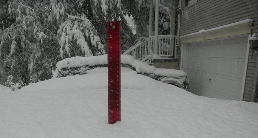
At 3:40, after shoveling the front, where we got at more than in inch while shoveling, I measured on the patio table in the back. 10 3/4 inches:
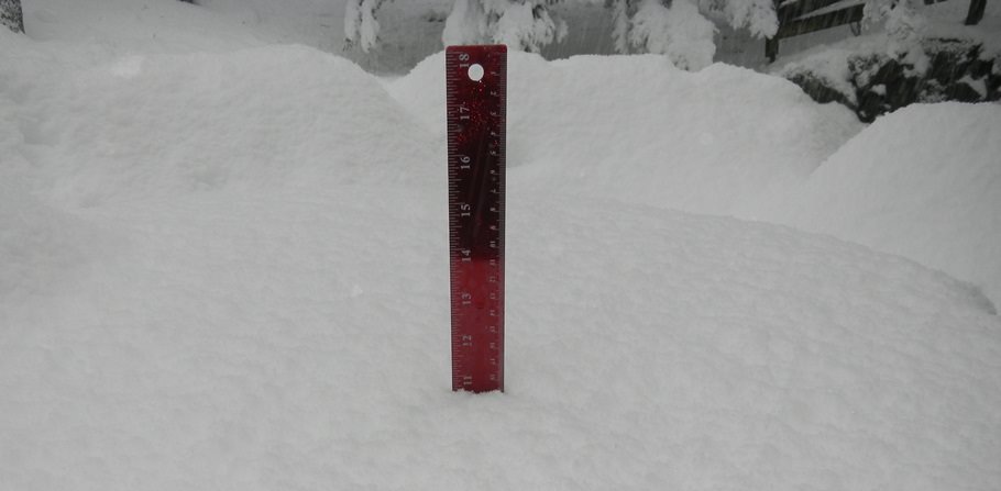
And it's still coming down. Very wet and heavy snow on the driveway, glad we're doing it in shifts.
At 3:40, after shoveling the front, where we got at more than in inch while shoveling, I measured on the patio table in the back. 10 3/4 inches:
And it's still coming down. Very wet and heavy snow on the driveway, glad we're doing it in shifts.
Not here. The amount of snow in Bucks County is unreal. At my store in NE Philly I would agree with you. We have more than a foot and most of it came in the last 2 hours.
Overall across the board it has compared to the projected maps.
We have about 5 inches here in Philly and it's already melting on the roads.
At least a foot in New Providence and still coming down heavily. Lost one of the trunks of a medium sized tree while digging out and now dealing with a power outages
Overall this thing underperformed.
Have over a foot with more coming...NOT underperforming here!
Yes we are getting crushed.Morris County getting crushed...complete white out for last 3 hours

Similar threads
- Replies
- 771
- Views
- 20K
- Replies
- 608
- Views
- 18K
OT: Minor to Moderate (2-4?) Snowfall Likely Sat morning (2/17); will be <32F, so expect slick roads
- Replies
- 213
- Views
- 5K
ADVERTISEMENT
Latest posts
-

-
 Football Rutgers Football lands Ohio transfer OL Shedrick Rhodes Jr.
- Latest: DennisHajekRC84
-
ADVERTISEMENT