Still plenty of snow storm jacking off to come.That's definitely not gonna satisfy some.


Colleges
- AAC
- ACC
- Big 12
- Big East
- Big Ten
- Pac-12
- SEC
- Atlantic 10
- Conference USA
- Independents
- Junior College
- Mountain West
- Sun Belt
- MAC
- More
- Navy
- UAB
- Tulsa
- UTSA
- Charlotte
- Florida Atlantic
- Temple
- Rice
- East Carolina
- USF
- SMU
- North Texas
- Tulane
- Memphis
- Miami
- Louisville
- Virginia
- Syracuse
- Wake Forest
- Duke
- Boston College
- Virginia Tech
- Georgia Tech
- Pittsburgh
- North Carolina
- North Carolina State
- Clemson
- Florida State
- Cincinnati
- BYU
- Houston
- Iowa State
- Kansas State
- Kansas
- Texas
- Oklahoma State
- TCU
- Texas Tech
- Baylor
- Oklahoma
- UCF
- West Virginia
- Wisconsin
- Penn State
- Ohio State
- Purdue
- Minnesota
- Iowa
- Nebraska
- Illinois
- Indiana
- Rutgers
- Michigan State
- Maryland
- Michigan
- Northwestern
- Arizona State
- Oregon State
- UCLA
- Colorado
- Stanford
- Oregon
- Arizona
- California
- Washington
- USC
- Utah
- Washington State
- Texas A&M
- Auburn
- Mississippi State
- Kentucky
- South Carolina
- Arkansas
- Florida
- Missouri
- Ole Miss
- Alabama
- LSU
- Georgia
- Vanderbilt
- Tennessee
- Louisiana Tech
- New Mexico State
- Middle Tennessee
- Western Kentucky
- UTEP
- Florida International University
High School
- West
- Midwest
- Northeast
- Southeast
- Other
- Alaska
- Arizona
- California
- Colorado
- Nevada
- New Mexico
- Northern California
- Oregon
- Southern California Preps
- Washington
- Edgy Tim
- Indiana
- Kansas
- Nebraska
- Iowa
- Michigan
- Minnesota
- Missouri
- Oklahoma Varsity
- Texas Basketball
- Texas
- Wisconsin
- Delaware
- Maryland
- New Jersey Basketball
- New Jersey
- New York City Basketball
- Ohio
- Pennsylvania
- Greater Cincinnati
- Virginia
- West Virginia Preps
ADVERTISEMENT
Install the app
How to install the app on iOS
Follow along with the video below to see how to install our site as a web app on your home screen.
Note: This feature may not be available in some browsers.
You are using an out of date browser. It may not display this or other websites correctly.
You should upgrade or use an alternative browser.
You should upgrade or use an alternative browser.
OT: Significant (CNJ) to Major (Along/N of 78) Winter Storm Likely on Tuesday (2/12-13; much less uncertainty on outcome)
- Thread starter RU848789
- Start date
And winter storm watches are up for the Poconos, Lehigh Valley, NW Bucks/Berks, Hunterdon, Morris, Sussex, Warren, W. Passaic, NW Bergen and the Hudson Valley N of the Tappan Zee. The watches are for 7-12" for Sussex/Poconos and 4-8 for the rest (except only 2-4" for Hunterdon, NW Bucks/Berks - surprised those were issued as the criterion is 6"). Eventually there will likely be advisories for the next tier of counties S of these counties - not sure if it'll include NYC/NENJ/Somerset/Middlesex though as the NWS is not calling for much there.
Also, the 18Z RGEM just came in much snowier than 12Z, with the 3" line along 276/185 and 4-7" north of there up to 84.
Also, the 18Z RGEM just came in much snowier than 12Z, with the 3" line along 276/185 and 4-7" north of there up to 84.

https://cdn.discordapp.com/attachme...6619f84dc5459a091383692302948ddcc7a83cc9011a&
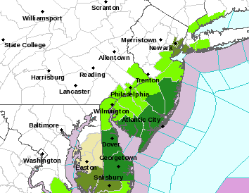
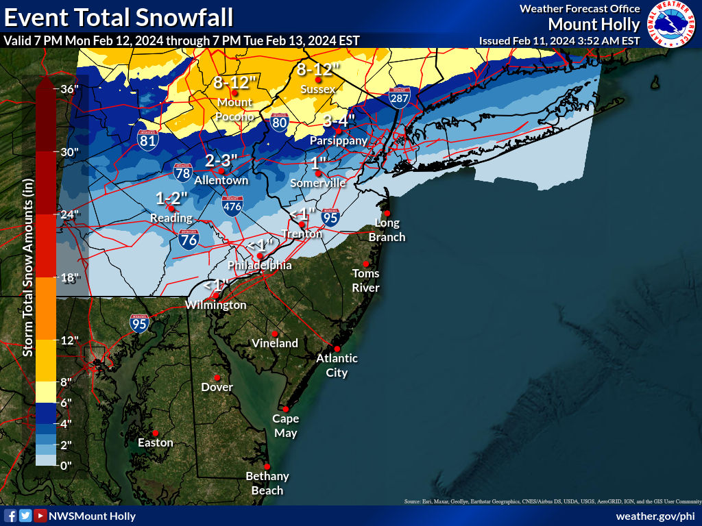
High end amounts per Mt Holly. Lots of areas approaching a foot. Seems bullish
High end amounts per Mt Holly. Lots of areas approaching a foot. Seems bullish
Let's the ready for some wishcasting!!!!!!!!!!!!!!!!!!!!!!!!!!!!!!!!!!!!!!!!clown maps are particularly useless with this type of storm
So after the 6Z models continued with fairly snowy outcomes, the 12Z models crushed the souls of snow lovers everywhere, lol. The GFS and Euro both moved north, bringing in warmer air and more mixing up through 95 reducing snowfall by at least half (but still significant snow N of 78), the CMC was all snow but much lighter (several inches for most vs. 6"+ for most) and only the UK got a bit snowier (6"+ for everyone); also the NAM went from 6"+ for most at 6Z to just several inches for most at 12Z (less precip), while the RGEM went from 4-7" for most to maybe 2-4" for most (also drier). The one thing many still point out is that the GFS and Euro ensembles didn't move nearly as far north as their op runs (with the EPS still showing 3-6" for CNJ/95 and the GEFS still showing 4-7" for those areas), implying it's possible those op runs were out of step with the overall setup, but that's a bit of guesswork.

Whoa? Allsnow thinks that? He’s usually a big weenie.They are extremely skeptical on the Americanwx board
Allsnow thinks just 1-2 mainly on grass in central jersey
lol a one in 10 shothttps://cdn.discordapp.com/attachme...6619f84dc5459a091383692302948ddcc7a83cc9011a&
High end amounts per Mt Holly. Lots of areas approaching a foot. Seems bullish
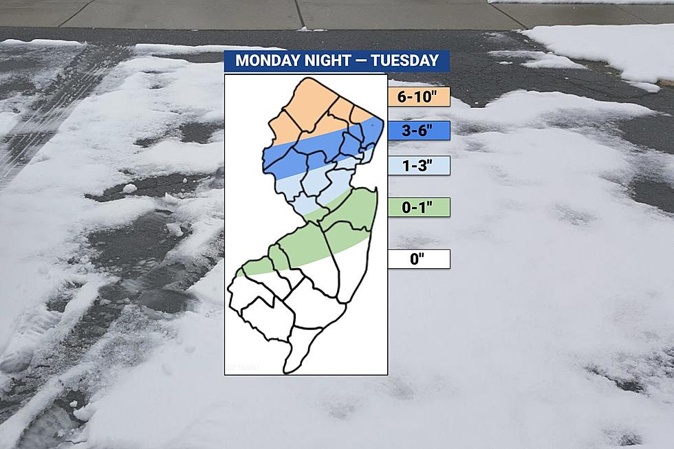
here is their latest map which cut back on the early one posted by Numbers
too warm, snow maps are not everythingWhoa? Allsnow thinks that? He’s usually a big weenie.
Anything that falls will likely melt on hard surfaces.....once again. This season has been another shovel free winter (just like 22/23). We shall see if it remains so.too warm, snow maps are not everything
It's the exact same map I posted earlier - this one just has exact location forecast accumulations, while the one I posted has ranges. Look at the color swaths on the maps - they're identical.here is their latest map which cut back on the early one posted by Numbers
So after the 6Z models continued with fairly snowy outcomes, the 12Z models crushed the souls of snow lovers everywhere, lol. The GFS and Euro both moved north, bringing in warmer air and more mixing up through 95 reducing snowfall by at least half (but still significant snow N of 78), the CMC was all snow but much lighter (several inches for most vs. 6"+ for most) and only the UK got a bit snowier (6"+ for everyone); also the NAM went from 6"+ for most at 6Z to just several inches for most at 12Z (less precip), while the RGEM went from 4-7" for most to maybe 2-4" for most (also drier). The one thing many still point out is that the GFS and Euro ensembles didn't move nearly as far north as their op runs (with the EPS still showing 3-6" for CNJ/95 and the GEFS still showing 4-7" for those areas), implying it's possible those op runs were out of step with the overall setup, but that's a bit of guesswork.
So, is this a trend that will be confirmed with the 18Z runs and 0Z runs tonight or was it more of a blip? We're closer to the event so the models should be more accurate, but with this fragile setup who knows. Time for more watching and waiting, but I would expect most forecasters to at least cut back on snowfall somewhat based on the 12Z models; there's always plenty of time to increase them again if the models trend back snowier.
I'll leave folks with the latest from the 18Z NAM. It looks a lot more like the snowy 6Z NAM (and not the low precip 12Z), as it shows a 5" line along 276/195 and 5-8", generally, north of there to 84. In addition, there is some rain on the front end, but most of the precip is snow as temps crash and the cold conveyor belt gets going, dynamically cooling the column, with surface temps in the 32-33F range for most of 95/CNJ from 4 am to 10 am when 90% of the snow falls. Will the other 18Z models trend back? Again, no clue, but will be interesting to watch as always.
Anyway, back to fun stuff. Had a great round of disc golf this morning and how about those Scarlet Knights opening up a can of whoop ass on the Badgers (JWill is a revelation)? Off shortly to a nice dinner at the Frog and the Peach with 3 other couples then likely going to see a couple of bands locally. So, if the snow threat dwindles further, I'll live, lol. Will check back in late tonight.
Not going to go back and rehash all the 18Z runs, other than to say that the Euro stayed the same as 12Z with much less snow for most, especially 95/CNJ, while the 18Z GFS was a bit snowier than the 12Z GFS. So, let's talk about the 0Z models tonight.
- The 0Z NAM just came out and is significantly snowier than 18Z, showing the 6" line from about Philly to Pt. Pleasant(with a very steep gradient to <1" just 25 miles S of that line) and 6-8", generally, north of there well past 84. The NAM is also probably the coldest model with some rain to start, but changing over around 4 am and putting down the 6"+ by 10-11 am, with surface temps in the 31-32F range while snowing along 95, so ratios are actually decent (near 10:1) from 95 north (but much lower towards the coast).
- The 0Z RGEM also just came out and is warmer/wetter than 18Z, with only a few inches along 95 (which could be very little with low ratios/melting, as it's warmer than the NAM with surface temps in the mid-30s when snowing) and little south of there, but it has a steep gradient with the 6" line being from about Easton to Yonkers.
- The GFS is the warmest and wettest it has been, after having been the most consistently snowy model for days, with only 1-2" S of 78, which would likely be white rain with warm surface temps, as modeled. It has 3-4" along 78 and 5-6" along 80 (and west of 287 for both cases) and a foot or more N of 84.
- And to muddle things more, the 0Z CMC is much snowier than at 12Z, with the 6" line roughly from Trenton to Middletown with 6-8" north of that line to 84 and the 3" line being from Philly to Pt. Pleasant; however, these are 10:1 ratio numbers and the CMC is in the mid-30s while snowing, so snowfall amounts might be half of those numbers from 95 to the coast.
- The UK went from very snowy at 12Z (6-8" for most) to much wetter at 0Z, with just a general 2-4" of snow from 276/195 up to 84 and less N of there (little precip N of 80 and substantial rain south of 78 before the change to snow)
- And the Euro at 0Z was similar to the not so snowy 18Z, with a 1" line along 276/195, a 3" line roughly along 78 and a 5" line along 80 with more to the N of 80, but those are 10:1 amounts and with temps around 34-36F south of 78, those amounts would likely be cut in half south of 78, i.e., lots of white rain.
The NBM has about 2.5" for my house (at a "realistic" snow ratio, supposedly), while the NWS has 1.5" for my house (again taking ratios/melting into account), so it's time for a guess and I'll split the difference and go with 2" for my house in Metuchen (with probably 4" worth of snow "falling" but only accumulating to 2"). If this snow were falling at midday and not 6-10 am, mostly, I'd lower that estimate.
https://www.americanwx.com/bb/topic...orm-likely-rain-snow-mix-on-feb-1314/page/23/
https://www.weather.gov/phi/
Last edited:
Starting to regret gassing up the snowblower. Leave for Arizona in 2 weeks and stay into March. Another nearly snowless winter at the shore.It's the exact same map I posted earlier - this one just has exact location forecast accumulations, while the one I posted has ranges. Look at the color swaths on the maps - they're identical.
Yeah for the Shore, things have trended wetter, although there could still be some periods of heavy snow Tuesday morning that might or might not accumulate a bit (an inch or less), but could very easily have visibility impacts.Starting to regret gassing up the snowblower. Leave for Arizona in 2 weeks and stay into March. Another nearly snowless winter at the shore.
I used a push broom for the last storm. My kind of snow.Yeah for the Shore, things have trended wetter, although there could still be some periods of heavy snow Tuesday morning that might or might not accumulate a bit (an inch or less), but could very easily have visibility impacts.
I did too - no brooms for this one where it accumulaes...I used a push broom for the last storm. My kind of snow.
bought a new snow shovel two years ago and have yet to use it…the drought continues.
Not going to go back and rehash all the 18Z runs, other than to say that the Euro stayed the same as 12Z with much less snow for most, especially 95/CNJ, while the 18Z GFS was a bit snowier than the 12Z GFS. So, let's talk about the 0Z models tonight.
The bottom line is that most of the models are now showing only a few inches south of 78 and much of that might not accumulate well, so an inch or less is looking more likely, but there are still a couple of models showing more, so it's hard to completely discount them, although at this point, about 48-54 hours from the start of precip (vs. the 0Z model runs 7 pm data inputs this evening), the chances of a return to the much more snowy outcomes on the models seen up until Saturday morning are very low. Once again, the NBM (model blend) is probably the way to go and this is still pretty close to what Channel 7 and other local media have, but a bit more than the NWS has.
- The 0Z NAM just came out and is significantly snowier than 18Z, showing the 6" line from about Philly to Pt. Pleasant(with a very steep gradient to <1" just 25 miles S of that line) and 6-8", generally, north of there well past 84. The NAM is also probably the coldest model with some rain to start, but changing over around 4 am and putting down the 6"+ by 10-11 am, with surface temps in the 31-32F range while snowing along 95, so ratios are actually decent (near 10:1) from 95 north (but much lower towards the coast).
- The 0Z RGEM also just came out and is warmer/wetter than 18Z, with only a few inches along 95 (which could be very little with low ratios/melting, as it's warmer than the NAM with surface temps in the mid-30s when snowing) and little south of there, but it has a steep gradient with the 6" line being from about Easton to Yonkers.
- The GFS is the warmest and wettest it has been, after having been the most consistently snowy model for days, with only 1-2" S of 78, which would likely be white rain with warm surface temps, as modeled. It has 3-4" along 78 and 5-6" along 80 (and west of 287 for both cases) and a foot or more N of 84.
- And to muddle things more, the 0Z CMC is much snowier than at 12Z, with the 6" line roughly from Trenton to Middletown with 6-8" north of that line to 84 and the 3" line being from Philly to Pt. Pleasant; however, these are 10:1 ratio numbers and the CMC is in the mid-30s while snowing, so snowfall amounts might be half of those numbers from 95 to the coast.
- The UK went from very snowy at 12Z (6-8" for most) to much wetter at 0Z, with just a general 2-4" of snow from 276/195 up to 84 and less N of there (little precip N of 80 and substantial rain south of 78 before the change to snow)
- And the Euro at 0Z was similar to the not so snowy 18Z, with a 1" line along 276/195, a 3" line roughly along 78 and a 5" line along 80 with more to the N of 80, but those are 10:1 amounts and with temps around 34-36F south of 78, those amounts would likely be cut in half south of 78, i.e., lots of white rain.
The NBM has about 2.5" for my house (at a "realistic" snow ratio, supposedly), while the NWS has 1.5" for my house (again taking ratios/melting into account), so it's time for a guess and I'll split the difference and go with 2" for my house in Metuchen (with probably 4" worth of snow "falling" but only accumulating to 2"). If this snow were falling at midday and not 6-10 am, mostly, I'd lower that estimate.
https://www.americanwx.com/bb/topic...orm-likely-rain-snow-mix-on-feb-1314/page/23/
https://www.weather.gov/phi/
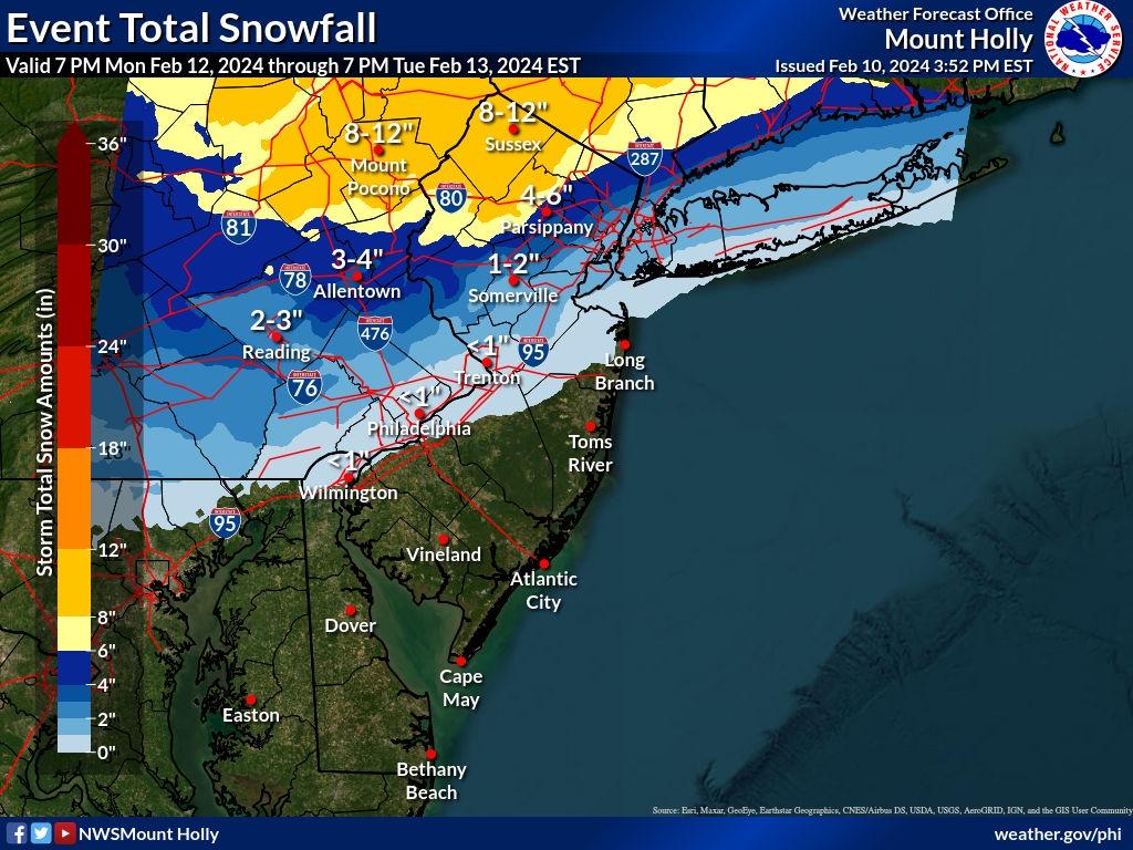
The NWS just came out with its updated snowmap, which didn't change that much from yesterday afternoon's map other than cutting back a little for areas south of 78. Also, winter storm watches continue for the Poconos and Sussex for 7-12” and for 4-9” for Warren, Morris, W. Passaic, W. Bergen and the Hudson Valley N of 287. They're also up for Hunterdon/NW Bucks/Berks for 2-4" of snow, which is very odd as the criterion is 6" - I imagine this will just become an advisory while the rest will likely become warnings, assuming no more major decreases in snowfall forecasts.
Also, the last holdout for 6" or more of snow for areas south of 78 and along 95 from Philly to NYC, the NAM, has caved to the rest of the guidance, with much less snow south of 78 at 6Z vs. 0Z. The 6" line is now along 78 instead of from Philly to Pt. Pleasant. Oh well. The 0Z CMC still had 6" along and N of 276/195, but it was much warmer than the NAM at the surface, so ratios would be far worse.
Edit: Although the 6Z RGEM just came out snowier (this is why forecasting can be so tough) with the 3" line from Trenton to Sandy Hook and the 6" line along 78 (at 10:1 which is not realistic for 95 and SE of 95 with surface temps 34-35F). And the 6Z GFS just came out snowier than 0Z, especially for areas between 195 and 78, including NYC with the 6" line roughly just south of 78 and the 3" line roughly from Trenton to Sayreville. Maybe the "trend" north has stopped? Time for sleep...
One thing worth noting for areas south of 78 that aren't expected to get more than 1-3" and might not have any accumulation on paved surfaces with surface temps in the mid-30s. Despite that, there could be periods of fairly heavy snowfall that greatly reduce visibility for those on the roads from about 5-10 am Tuesday.
Last edited:
So the biggest issue along the coast will be rain, winds, and tidal flooding here between 900A and 1130A Tue. Can deal with that.
You mean there are other sources for weather news??!!
That's a good call, IMO - very similar to Lee Goldberg's and a bit more bullish than the NWS.
Hey as long as you can make Snow Angels, right?That's a good call, IMO - very similar to Lee Goldberg's and a bit more bullish than the NWS.
It's going to be over 40 degrees on Tuesday. If anything even sticks (doubtful), just let it melt. No need for a broom.I used a push broom for the last storm. My kind of snow.
The mesoscale models (NAM/RGEM) which are now in the good part of their range (inside 48 hrs), are both showing moderate snowfall for 95 from Trenton to NYC, with the 3" line (10:1 - might see that on the colder NAM, won't see that on the warmer RGEM) from roughly Trenton to Sandy Hook and with 5-6" along 78 and more north of there. Also starting to see a sleet signature from the models at times.The NWS just came out with its updated snowmap, which didn't change that much from yesterday afternoon's map other than cutting back a little for areas south of 78. Also, winter storm watches continue for the Poconos and Sussex for 7-12” and for 4-9” for Warren, Morris, W. Passaic, W. Bergen and the Hudson Valley N of 287. They're also up for Hunterdon/NW Bucks/Berks for 2-4" of snow, which is very odd as the criterion is 6" - I imagine this will just become an advisory while the rest will likely become warnings, assuming no more major decreases in snowfall forecasts.
Also, the last holdout for 6" or more of snow for areas south of 78 and along 95 from Philly to NYC, the NAM, has caved to the rest of the guidance, with much less snow south of 78 at 6Z vs. 0Z. The 6" line is now along 78 instead of from Philly to Pt. Pleasant. Oh well. The 0Z CMC still had 6" along and N of 276/195, but it was much warmer than the NAM at the surface, so ratios would be far worse.
Edit: Although the 6Z RGEM just came out snowier (this is why forecasting can be so tough) with the 3" line from Trenton to Sandy Hook and the 6" line along 78 (at 10:1 which is not realistic for 95 and SE of 95 with surface temps 34-35F). And the 6Z GFS just came out snowier than 0Z, especially for areas between 195 and 78, including NYC with the 6" line roughly just south of 78 and the 3" line roughly from Trenton to Sayreville. Maybe the "trend" north has stopped? Time for sleep...
One thing worth noting for areas south of 78 that aren't expected to get more than 1-3" and might not have any accumulation on paved surfaces with surface temps in the mid-30s. Despite that, there could be periods of fairly heavy snowfall that greatly reduce visibility for those on the roads from about 5-10 am Tuesday.
In addition, both the GFS and CMC are still showing at least moderate snow for 95/CNJ (2-6" range at 10:1, maybe 2/3 of that with Kuchera), which is pretty similar to the NAM/RGEM and both models are showing 6" or more along and N of 78, so this could end up being a really close call between 1-2" of slop and 3-5" of snow for areas 10-20 miles south of 78, i.e., from about New Hope to Sayreville and north of there to 78, which would include places like Flemington, Hillsborough, NB, and Perth Amboy.
So while the threat is not for major snow for 95 (as was being shown 2 days ago), it's not dead for getting 2-4" all in a few hours coinciding with rush hour with heavy snowfall rates and poor visibility (even if accumulations on treated roads are unlikely). And for areas along/N of 78 this will likely be a very impactful storm unless we see last minute track shift north, bringing more warmth/rain northward.
Edit: the 12Z UK is showing a general 3-5" for all of EPA/NJ along/N of 276/195 (at 10:1; with surface temps 33-34F, that probably means 2-4"), which is snowier than last night. Note that this falls after a fair amount of rain (1/2" or so) as for most of the models and the model doesn't show >6" anywhere (less precip for the north).
Edit: and the Euro moves south a bit bringing more snow southward, with the model now showing about 2" along 276/195 and 5-6" along 78 with increasing amounts from 195 up to 78, as expected. These are at 10:1 ratios and should probably be cut by 1/3 to 1/2 as surface temps are in the 34-36F range for much of the snow south of 78 (and 32-34F along/N of 78, so ratios closer to 8-9:1).
Last edited:
Here's the coastal flooding discussion from the NWS. Could be moderate flooding with the storm and could also see 40-45 mph gusts at the coast at the height of the storm Tuesday morning (more like 30-35 mph inland). Also, the NWS still has the coast in a 10% chance of getting 1-2" of snow (from about Toms River to AP).So the biggest issue along the coast will be rain, winds, and tidal flooding here between 900A and 1130A Tue. Can deal with that.
.TIDES/COASTAL FLOODING...
Minor coastal flooding is forecast to continue occurring with
the morning to early/mid afternoon high tides through Tuesday
along Atlantic coastal New Jersey & Delaware, Delaware Bay, and
the tidal Delaware River. The astronomical tides will be
lessening with time as we get farther away from the New Moon,
which occurred on Friday. Thus, the flooding with subsequent
high tides Sunday and Monday may not be quite as widespread or
impactful. Nevertheless, we are still forecasting minor coastal
flooding to occur at all forecast points in the aforementioned
areas. A new Coastal Flood Advisory was issued for the Sunday
high tide. This may need to be extended through Monday.
A strong coastal system pushing offshore early Tuesday is
forecast to result in increasing surge values upwards of 2-3
feet above the astronomical tides, which will result in
more widespread and impactful coastal flooding issues with the
high tides on Tuesday. The peak of the surge appears to
coincide with the high tide along much of the Atlantic coast of
New Jersey Tuesday morning. This is anticipated to result in a
threat for moderate flooding impacts from around Atlantic County
and north into Monmouth and Middlesex Counties. A Coastal Flood
Watch was issued for the Tuesday high tide in these areas to
highlight this threat.
Elsewhere along the Atlantic coast, Delaware Bay, and the tidal
Delaware River, widespread minor flooding is currently forecast
to occur with the Tuesday high tide. There is a possibility
(30-40% chance) of localized moderate coastal flooding impacts
in some back bays of Cape May and Sussex Counties with the
Tuesday high tide, however confidence at this point is too low
to justify a Watch for those areas. Additionally, the
widespread rainfall of 1-1.5" will lead to increased fresh
water runoff on Tuesday. This may lead to elevated water levels,
especially along tidal tributaries of the tidal Delaware River.
Thus, there is a possibility of localized moderate coastal
flooding impacts in some areas along the tidal Delaware River
with the Tuesday afternoon high tide as well.
No, the one thing that has been consistent is the timing. Starts as rain nearly everywhere late Monday night, changing to snow well NW of 95 by 1-2 am and by 3-4 am along 78 and by 5-6 am along 95 with heavy precip from about 3-4 am onward through about 10 am, when precip lightens up except from NYC eastward, where heavy precip clears out more like 12-1 pm. This is why, even if there isn't much accumulation along 95 due to low ratios and melting, visibility is going to likely be very poor from 6-10 am with heavy snow falling much of the time. And obviously, where it's accumulating well (along/N of 78 at least; less likely along 95) impacts will be much greater.Is it too early for timing? Specifically when is it out of here on Tuesday?
if people made it through the last storm which had similar type issues with wet snow moreso on grass than roads, they will largely be fine through this one. That storm slightly overperformed in some areas though for the public they are concerned with what falls on their sidewalks and driveways more so than the grass blades


lol, it just might be given warming trends...78 is the new 95
Where you guys at-hopefully somewhere warm with no snow?You mean there are other sources for weather news??!!
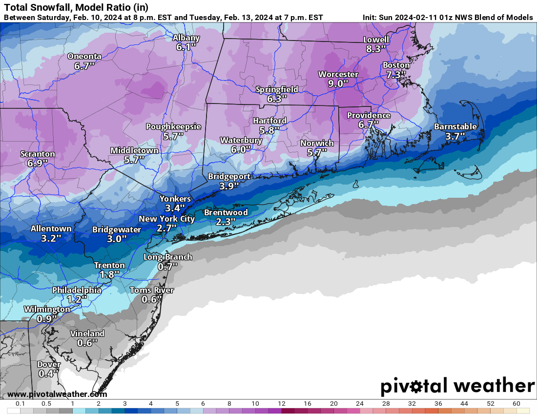
Great chart, very helpful. Thanks for posting!
Just added the edits above, with both the UK and Euro increasing snowfall amounts a bit vs. previous runs. So, overall, the 12Z suite was nearly unanimous in increasing snowfall between 276/195 and 78 and especially along and just NW of 95 from Trenton to NYC and even a bit towards the coast. We might see the NWS up snowfall amounts a bit (maybe by an inch?) for these areas at 4 pm. Still 36-42 hours before precip starts and even small track/temp changes can have a moderate impact in snowfall amounts.The mesoscale models (NAM/RGEM) which are now in the good part of their range (inside 48 hrs), are both showing moderate snowfall for 95 from Trenton to NYC, with the 3" line (10:1 - might see that on the colder NAM, won't see that on the warmer RGEM) from roughly Trenton to Sandy Hook and with 5-6" along 78 and more north of there. Also starting to see a sleet signature from the models at times.
In addition, both the GFS and CMC are still showing at least moderate snow for 95/CNJ (2-6" range at 10:1, maybe 2/3 of that with Kuchera), which is pretty similar to the NAM/RGEM and both models are showing 6" or more along and N of 78, so this could end up being a really close call between 1-2" of slop and 3-5" of snow for areas 10-20 miles south of 78, i.e., from about New Hope to Sayreville and north of there to 78, which would include places like Flemington, Hillsborough, NB, and Perth Amboy.
So while the threat is not for major snow for 95 (as was being shown 2 days ago), it's not dead for getting 2-4" all in a few hours coinciding with rush hour with heavy snowfall rates and poor visibility (even if accumulations on treated roads are unlikely). And for areas along/N of 78 this will likely be a very impactful storm unless we see last minute track shift north, bringing more warmth/rain northward.
Edit: the 12Z UK is showing a general 3-5" for all of EPA/NJ along/N of 276/195 (at 10:1; with surface temps 33-34F, that probably means 2-4"), which is snowier than last night. Note that this falls after a fair amount of rain (1/2" or so) as for most of the models and the model doesn't show >6" anywhere (less precip for the north).
Edit: and the Euro moves south a bit bringing more snow southward, with the model now showing about 2" along 276/195 and 5-6" along 78 with increasing amounts from 195 up to 78, as expected. These are at 10:1 ratios and should probably be cut by 1/3 to 1/2 as surface temps are in the 34-36F range for much of the snow south of 78 (and 32-34F along/N of 78, so ratios closer to 8-9:1).
This is good stuff. But I'm more interested in the Jeremiah Williams Euro Step.Just added the edits above, with both the UK and Euro increasing snowfall amounts a bit vs. previous runs. So, overall, the 12Z suite was nearly unanimous in increasing snowfall between 276/195 and 78 and especially along and just NW of 95 from Trenton to NYC and even a bit towards the coast. We might see the NWS up snowfall amounts a bit (maybe by an inch?) for these areas at 4 pm. Still 36-42 hours before precip starts and even small track/temp changes can have a moderate impact in snowfall amounts.
Similar threads
- Replies
- 62
- Views
- 2K
OT: Minor to Moderate (2-4?) Snowfall Likely Sat morning (2/17); will be <32F, so expect slick roads
- Replies
- 213
- Views
- 5K
- Replies
- 477
- Views
- 12K
- Replies
- 592
- Views
- 16K
- Replies
- 771
- Views
- 20K
ADVERTISEMENT
Latest posts
-
 Podcast Athan Kaliakmanis named QB1 + Gavin Wimsatt to the Portal
- Latest: Rusty_Screw_88
-
-

-

ADVERTISEMENT