Surprised nobody posted about this yet, so here you go. In this lousy winter for snow lovers, even the chance of a dusting to 1/2" of snow, tomorrow, is noteworthy, plus there's the chance of more substantial wintry weather, especially N of 78, on Monday night/Tuesday morning.
For tomorrow, there are two weak systems approaching, one a clipper style system from the NW and one a disorganized coastal low and both of them could produce snow showers/light snow during the day tomorrow, with the first one possibly affecting areas NW of 95, including NYC, and the second one possibly affecting SNJ, the Jersey Shore and LI. We're only talking about a dusting to maybe 1/2" of snow during the day, as per the NWS map below (with a couple of models showing some places maybe getting up to 1"), but in a winter with <1/2" of snow so far for most people along and SE of the 95 corridor (and not much more even well NW of 95) this is worth a mention, IMO. The "hole" in the snowfall map below is the area where neither system might have much impact.
For the Mon/Tues system, we'll have a storm approaching from the midwest bringing moisture to our area from the SW with some (but not a lot) cold air in place, so the precip could start as snow even as far south as 195/276, but will likely change to rain fairly quickly up to about 78, as warm air moves in off the ocean with formation of a secondary coastal low, with small accumulations possible south of 78. However, for areas N of 78, most models are showing at least a few inches of snow/sleet before a changeover to rain with significant snowfall (4" or more) possible north of 80. For areas that see mostly rain, up to 1" could fall.
This system could be much wetter if the primary low to our west/NW remains dominant and it could be whiter if the secondary coastal low becomes stronger, but we won't know how that plays out for another day or two, probably, as we're still 3-4 days out. Still, just the chance of some more snow in this winter is worth discussing, as February is just about over and we realistically only have about 3-4 more weeks of potential snow, as we don't usually get much snow after about 3/20.
https://www.weather.gov/phi/
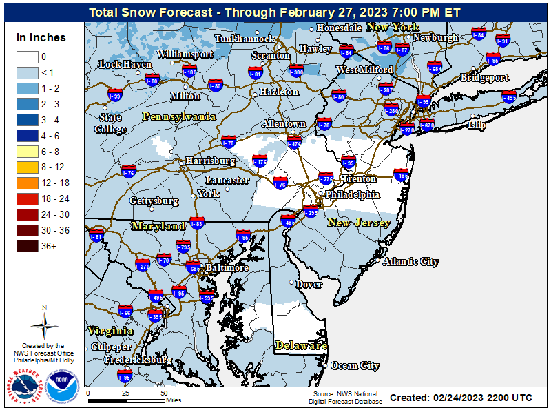
Last edited: