
Hillsborough Deli has much higher standards.why dont you want some snow
a nice 2-3 inches every few days would be awesome
Colleges
- American Athletic
- Atlantic Coast
- Big 12
- Big East
- Big Ten
- Colonial
- Conference USA
- Independents (FBS)
- Junior College
- Mountain West
- Northeast
- Pac-12
- Patriot League
- Pioneer League
- Southeastern
- Sun Belt
- Army
- Charlotte
- East Carolina
- Florida Atlantic
- Memphis
- Navy
- North Texas
- Rice
- South Florida
- Temple
- Tulane
- Tulsa
- UAB
- UTSA
- Boston College
- California
- Clemson
- Duke
- Florida State
- Georgia Tech
- Louisville
- Miami (FL)
- North Carolina
- North Carolina State
- Pittsburgh
- Southern Methodist
- Stanford
- Syracuse
- Virginia
- Virginia Tech
- Wake Forest
- Arizona
- Arizona State
- Baylor
- Brigham Young
- Cincinnati
- Colorado
- Houston
- Iowa State
- Kansas
- Kansas State
- Oklahoma State
- TCU
- Texas Tech
- UCF
- Utah
- West Virginia
- Illinois
- Indiana
- Iowa
- Maryland
- Michigan
- Michigan State
- Minnesota
- Nebraska
- Northwestern
- Ohio State
- Oregon
- Penn State
- Purdue
- Rutgers
- UCLA
- USC
- Washington
- Wisconsin
High Schools
- Illinois HS Sports
- Indiana HS Sports
- Iowa HS Sports
- Kansas HS Sports
- Michigan HS Sports
- Minnesota HS Sports
- Missouri HS Sports
- Nebraska HS Sports
- Oklahoma HS Sports
- Texas HS Hoops
- Texas HS Sports
- Wisconsin HS Sports
- Cincinnati HS Sports
- Delaware
- Maryland HS Sports
- New Jersey HS Hoops
- New Jersey HS Sports
- NYC HS Hoops
- Ohio HS Sports
- Pennsylvania HS Sports
- Virginia HS Sports
- West Virginia HS Sports
ADVERTISEMENT
You are using an out of date browser. It may not display this or other websites correctly.
You should upgrade or use an alternative browser.
You should upgrade or use an alternative browser.
OT: Snow? - January 15-16?
- Thread starter Tango Two
- Start date

Hillsborough Deli has much higher standards.
And a higher reading peter meter.
ouch the 18z gfs was one for the fishes
could brush the coast with an inch
It’s the 18z gfs…
Shouldn’t take much away from it
You dirty birds. I should’ve known better before posting that.I love it when a plan comes together.
I was gonna say "the 7 year old in me thanks you for posting it and making my childish humor possible". But then I thought twice and decided, I better not say that.You dirty birds. I should’ve known better before posting that.
Oops. Doh!
I can’t believe I spaced out and left a hanging curve over the plate like that. 😂I was gonna say "the 7 year old in me thanks you for posting it and making my childish humor possible". But then I thought twice and decided, I better not say that.
Oops. Doh!
🤣Because the usage I'm using is mayhem representing disorder and chaos and if you had experience with numerical model prediction of deterministic, but non-linear and chaotic systems like the weather, you'd know why we're seeing such varied outcomes given similar models and similar initial conditions. I've done very similar modeling for chemical reactors (similar to the weather, just on a much smaller scale, which decreases complexity vs. global weather, but with changing materials over time, which adds complexity) and it's amazing how much small starting point changes (and model physics) can influence eventual outcomes.
ouch the 18z gfs was one for the fishes
could brush the coast with an inch
18z euro also a swing and a miss.
When euro and gfs are in lockstep..it’s pretty good.
See if 0z holds serve..if so, bad trend for snow
18Z GFS was similar to 12Z (largely a miss SE), but the 18Z Euro only runs 90 hours, to 7 am Tuesday, so we don't know yet whether it would have been a miss to the SE again (more likely than not, but we can't be sure). At this point it's CMC/UK showing substantial storms with snow/mix/rain for our area vs. the GFS/Euro both showing a weak, strung out miss to the SE with only a little snow (1", maybe 2"). We've been here before, almost 4 days out with wildly varying projected outcomes and have ended up snowy, mixed, rainy and no precip, i.e., all of these solutions are still on the table, so we track.18z euro also a swing and a miss.
When euro and gfs are in lockstep..it’s pretty good.
See if 0z holds serve..if so, bad trend for snow
Not looking good so far:18z euro also a swing and a miss.
When euro and gfs are in lockstep..it’s pretty good.
See if 0z holds serve..if so, bad trend for snow

Not looking good so far:
Not looking good, not looking bad. Certainly a storm possible so need to keep watching
Wishcast. 😎Not looking good, not looking bad. Certainly a storm possible so need to keep watching
Well, today wasn't a good day for snow lovers, as tonight's models continue the trend of a fairly weak storm on all of the models and a storm with most of the precip offshore, but having said that a 1-2"/2-4" outcome is starting to look more likely, as every model has at least an inch or so and some have several inches.18Z GFS was similar to 12Z (largely a miss SE), but the 18Z Euro only runs 90 hours, to 7 am Tuesday, so we don't know yet whether it would have been a miss to the SE again (more likely than not, but we can't be sure). At this point it's CMC/UK showing substantial storms with snow/mix/rain for our area vs. the GFS/Euro both showing a weak, strung out miss to the SE with only a little snow (1", maybe 2"). We've been here before, almost 4 days out with wildly varying projected outcomes and have ended up snowy, mixed, rainy and no precip, i.e., all of these solutions are still on the table, so we track.
Specifically, the 0Z GFS has about 1" area-wide with temps below 32F the whole time and the Euro has 1-2" area-wide also with temps below 32F; both models have significant precip 250-300 miles offshore.
On the other hand, the UK has 3-6" NW of 95 (all snow), 1-3" for the 95 corridor and <1" SE of 95 with the lower amounts due to rain/sleet changeover as temps go above 32F by about noon Tuesday. And the CMC has 1-3" NW of 95 and 3-5" along and SE of 95 to the coast, with temps never going above 32F.
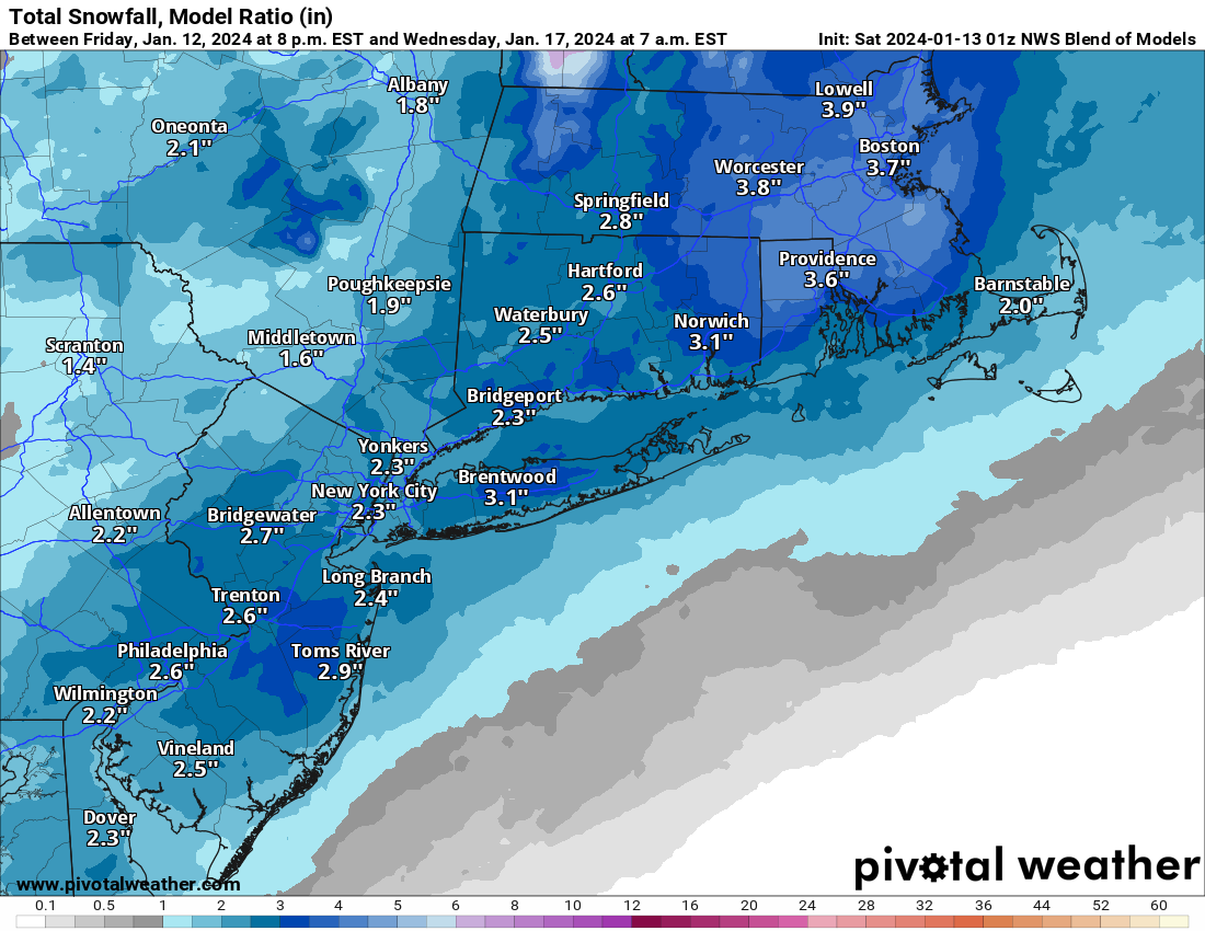
It's kind of easy to see how the 0Z NBM (National Blend of Models) has an area-wide 2-3" (with locally up to 4") given the model outcomes; see below. As expected this is down substantially from the 3-6" amounts the NBM was showing area-wide 24 hours ago. Also worth noting that with temps below 32F, it's possible we get snow:liquid ratios >10:1, giving NYC/Philly/DC/Balt a better chance of getting that elusive 1" or more (on a calendar day basis - NYC did get about 1.5" over 2 days last winter).
At this point, we're still 3+ days from the start of the event early Tuesday, so much can still change, especially once the energy for the system comes ashore tomorrow night and is better sampled by the RAOB network, leading to more accurate models from better starting data. But it's looking a lot less likely that anyone sees over 6" or that the storm is a complete miss. Note that the 0Z NAM/RGEM won't really be within good range for another 24 hours. More model runs tomorrow...
Last edited:
Winters in NJ are now sadly dominated by cold rain. Snow has become a myth.
Well, today wasn't a good day for snow lovers, as tonight's models continue the trend of a fairly weak storm on all of the models and a storm with most of the precip offshore, but having said that a 1-2"/2-4" outcome is starting to look more likely, as every model has at least an inch or so and some have several inches.
Specifically, the 0Z GFS has about 1" area-wide with temps below 32F the whole time and the Euro has 1-2" area-wide also with temps below 32F; both models have significant precip 250-300 miles offshore.
On the other hand, the UK has 3-6" NW of 95 (all snow), 1-3" for the 95 corridor and <1" SE of 95 with the lower amounts due to rain/sleet changeover as temps go above 32F by about noon Tuesday. And the CMC has 1-3" NW of 95 and 3-5" along and SE of 95 to the coast, with temps never going above 32F.
It's kind of easy to see how the 0Z NBM (National Blend of Models) has an area-wide 2-3" (with locally up to 4") given the model outcomes; see below. As expected this is down substantially from the 3-6" amounts the NBM was showing area-wide 24 hours ago. Also worth noting that with temps below 32F, it's possible we get snow:liquid ratios >10:1, giving NYC/Philly/DC/Balt a better chance of getting that elusive 1" or more (on a calendar day basis - NYC did get about 1.5" over 2 days last winter).
At this point, we're still 3+ days from the start of the event early Tuesday, so much can still change, especially once the energy for the system comes ashore tomorrow night and is better sampled by the RAOB network, leading to more accurate models from better starting data. But it's looking a lot less likely that anyone sees over 6" or that the storm is a complete miss. Note that the 0Z NAM/RGEM won't really be within good range for another 24 hours. More model runs tomorrow...
Where do I find these maps for VT?
Its basically a 1-3 inch snow event at this point...could be tweaked downward depending on modelling. No model showing anything major at this point
Nam is wet rather than white but its out of its range
Nam is wet rather than white but its out of its range
Looking like Tuesday morning/afternoon, but with only a 1-3" event, if that (since there are models with <1"), and snow intensity likely being on the light to moderate side with temps around 32F, even with a low sun angle in mid-Jan, I would not expect much accumulation on roads (unless the colder models verify which have temps in the upper 20s, which would allow more snow to accumulate), so I would imagine a lot more delayed openings than closures. As per the current models, which are subject to change, as we all know.Is this going to be a Tuesday daytime event in North Jersey? So only if only a couple inches, they may cancel school anyway?
@pmvon - here's the latest NBM, which includes Vermont. The NBM dropped a bit more at 12Z today vs. 0Z last night with just 1-2" forecast.

Snowfall amounts continue their downward trend. It happens. The models just aren't seeing any consolidation/phasing of the northern and southern jet stream energies, as they were seeing a couple of days ago, meaning we're seeing a strung out mess of mostly light precip (mostly snow) for our area with temps likely at or below 32F, although some rain for the coast can't be ruled out. The NBM (blend of models) is now down to a 1-2" event for our area on Tuesday morning into the afternoon as I just posted above, but the models, themselves are still showing significant differences from each other.Well, today wasn't a good day for snow lovers, as tonight's models continue the trend of a fairly weak storm on all of the models and a storm with most of the precip offshore, but having said that a 1-2"/2-4" outcome is starting to look more likely, as every model has at least an inch or so and some have several inches.
Specifically, the 0Z GFS has about 1" area-wide with temps below 32F the whole time and the Euro has 1-2" area-wide also with temps below 32F; both models have significant precip 250-300 miles offshore.
On the other hand, the UK has 3-6" NW of 95 (all snow), 1-3" for the 95 corridor and <1" SE of 95 with the lower amounts due to rain/sleet changeover as temps go above 32F by about noon Tuesday. And the CMC has 1-3" NW of 95 and 3-5" along and SE of 95 to the coast, with temps never going above 32F.
It's kind of easy to see how the 0Z NBM (National Blend of Models) has an area-wide 2-3" (with locally up to 4") given the model outcomes; see below. As expected this is down substantially from the 3-6" amounts the NBM was showing area-wide 24 hours ago. Also worth noting that with temps below 32F, it's possible we get snow:liquid ratios >10:1, giving NYC/Philly/DC/Balt a better chance of getting that elusive 1" or more (on a calendar day basis - NYC did get about 1.5" over 2 days last winter).
At this point, we're still 3+ days from the start of the event early Tuesday, so much can still change, especially once the energy for the system comes ashore tomorrow night and is better sampled by the RAOB network, leading to more accurate models from better starting data. But it's looking a lot less likely that anyone sees over 6" or that the storm is a complete miss. Note that the 0Z NAM/RGEM won't really be within good range for another 24 hours. More model runs tomorrow...
The 12Z GFS is a weak mess with <1" of snow for the area, the CMC is a bit more potent with 1-3" for most of the area and the RGEM/NAM, which are mesoscale models (not global) and a bit out of their useful range by Tuesday am (they run out to 84 hrs, which is Tues at 7 pm). The RGEM is showing 1-2" for the area, while the NAM is showing 2-4" well NW but down to 1" or less for 95 to the coast due to significant warming/rain, but it's the only model showing this much warmth. The ICON (German model), which I don't usually mention, but which is gaining some respect, shows 2-4" for the area. UK and Euro to come.
Still 3+ days out, though, so significant changes are still possible, although starting to become less likely as we get closer to the event.
Edit: just when the snow lovers were looking over the precipice, the UK comes in with a 3-5" snowfall for the whole area (except 1-3" for the immediate coast), lol.
And the 12Z Euro puts down 1-2" of powder at below 32F temps (should be decent ratio snow) vs. only about 1/2" at 6Z.
Looks like maybe we're zeroing in on a 1-3" event with a 3-5" still possible as is <1". I don't think a complete miss is realistic anymore.
Lastly, there have been signals for a few days for a winter storm on 1/19-1/20, which is 7 days away. Those signals are getting stronger, but as we've seen with this event and many others, strong signals, even at 5-6 days, don't always pan out (in case you see snowfall maps from today's 12Z GFS start to circulate on social media).
Last edited:
Nothing wrong with inch or 1 event that will hang around as we get our coldest air of season that should last at least a week
18Z NAM comes in as a nice hit for the region (3-6" with the most along 95 rom DC to Boston), after showing mostly rain from 95/SE last run...so don't get too excited, but still a nice change if you like snow.
is that going to be accumulating on surfaces? Still awaiting snow fun for my kid.18Z NAM comes in as a nice hit for the region (3-6" with the most along 95 rom DC to Boston), after showing mostly rain from 95/SE last run...so don't get too excited, but still a nice change if you like snow.
As modeled with temps below 32F everywhere except maybe the immediate coast, yes, accumulation will occur on all untreated surfaces.is that going to be accumulating on surfaces? Still awaiting snow fun for my kid.
of course the nam is out of its range and also known for being way too juiced so its an auto toss until any other models shows something similar
And the 18Z RGEM comes in similarly to 12Z, with a general 1-3" for 95 and NW of there and maybe only an inch or so towards the coast (mixing), while the 18Z GFS looks pretty similar to its last run with a general 1" or so for most - still fairly weak and strung out. Haven't seen anything yet that makes me think 1-3" isn't a decent call right now, which is what the NBM is still showing generally. Let's see what tonight brings...18Z NAM comes in as a nice hit for the region (3-6" with the most along 95 rom DC to Boston), after showing mostly rain from 95/SE last run...so don't get too excited, but still a nice change if you like snow.
Keep in mind that both the NAM and RGEM are still in their less accurate range, i.e., most of the precip falls after hour 60 and both mesoscale models are better inside of about 48 hours typically.
Agree. We should not be seeing any NAM in this thread right now. Even an uneducated weather peasant like me knows that. I’m sure Allsnow popped a bottle of champagne over that run though.of course the nam is out of its range and also known for being way too juiced so its an auto toss until any other models shows something similar
18z gfs is a coating to an inch
all indications are this is a light event across the area giving an inch or two that will pepper the ground with white but the bigger story will be the cold which will keep temps in the 30s during the day and teens at night from Tuesday through early next week. Possible system next weekend but signals that it turns warmer after the 20th
all indications are this is a light event across the area giving an inch or two that will pepper the ground with white but the bigger story will be the cold which will keep temps in the 30s during the day and teens at night from Tuesday through early next week. Possible system next weekend but signals that it turns warmer after the 20th
I think I shall keep the snowblower in the box and on the crate. I must say, so far this has been one of the worst purchases of my entire life. I'm coming up on my 2yr. warranty and at this point, I don't even give a sh*t if it starts.
Partly agree. It was already looking like it would be snowier 48-60 hours into the run, so it's not like some big changes occurred at 78 hours. Also, the NAM has occasionally been right at 60+ hours, so tossing it is an overreaction, just like touting it would be.Agree. We should not be seeing any NAM in this thread right now. Even an uneducated weather peasant like me knows that. I’m sure Allsnow popped a bottle of champagne over that run though.
For whom? We got 2" in Metuchen and everywhere within 5-10 miles south of 78 got ~3" and folks along/N of 78 got 4"+ for the most part. Only folks SE of 95 in CNJ got nada (and along 95 SW of Trenton). It's possible this system only delivers an inch or even less, but that's not the way it looks now, plus whatever accumulates will likely stick around for a week, especially for anyone who gets 2"+, since it might not get above 32F for a week.Gonna be like the other day… barely a dusting to an inch
Snow squall line for tomorrow around 12-3 pm (this map is at 1 pm and the line reaches the coast around 3 pm) looks pretty cool, unless you get caught driving in it and your visibility suddenly goes to 100-200 yards in a 10 minute snow squall. Could put down a quick 1/4-1/2" for some, especially NW of 95 and N of 78. Could also be a rain/snow mix squall SE of 95.

Last edited:
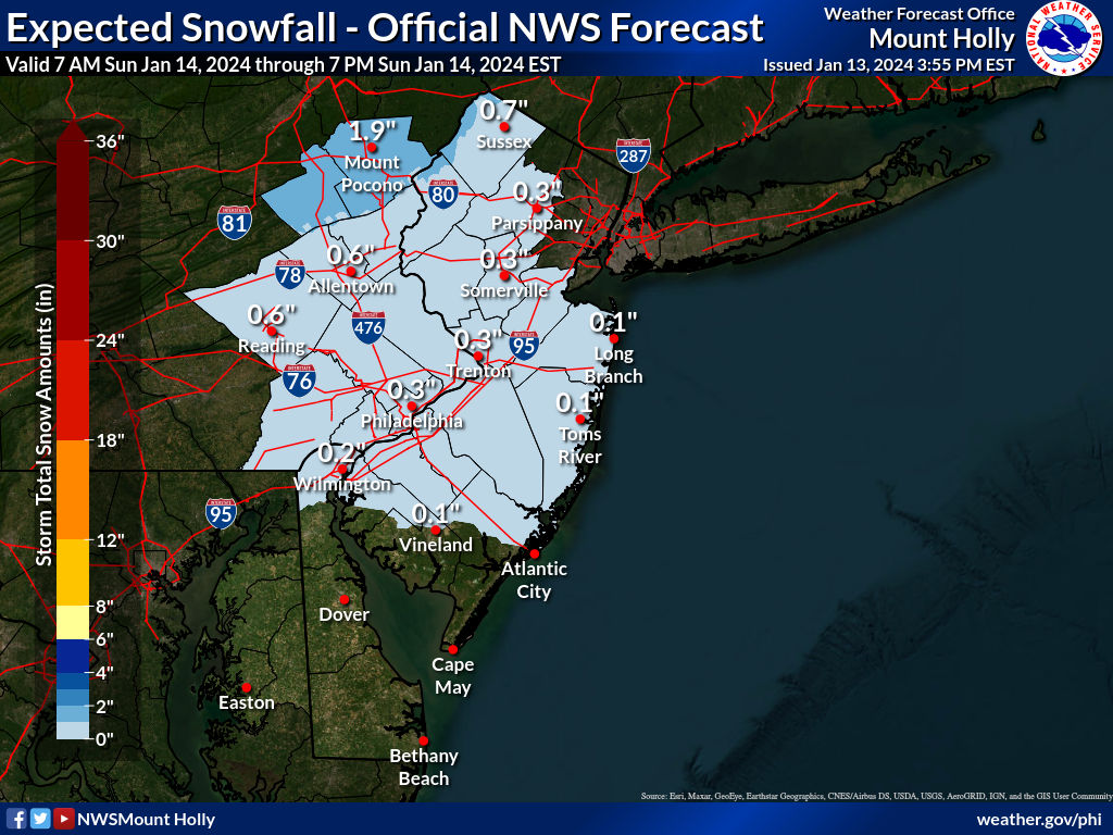
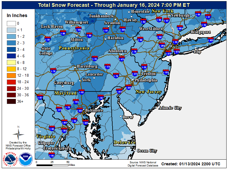
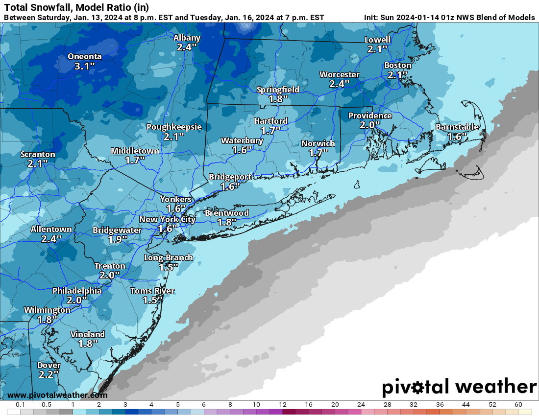
NWS has put up a snow map for the 1/16 event forecasting a general 1-2" area-wide with up to 3" in spots. Pretty well aligned with the NBM forecast.
One more 18Z model: the Euro came in a bit snowier than the last couple of runs, with 1-2" area wide on Tuesday with a few spots above 2", plus with cold temps (never above 32F except at the coast for a bit in the 33-34F range), we could see good ratios and won't see much melting.And the 18Z RGEM comes in similarly to 12Z, with a general 1-3" for 95 and NW of there and maybe only an inch or so towards the coast (mixing), while the 18Z GFS looks pretty similar to its last run with a general 1" or so for most - still fairly weak and strung out. Haven't seen anything yet that makes me think 1-3" isn't a decent call right now, which is what the NBM is still showing generally. Let's see what tonight brings...
Keep in mind that both the NAM and RGEM are still in their less accurate range, i.e., most of the precip falls after hour 60 and both mesoscale models are better inside of about 48 hours typically.
Supposed to fly from Florida into Philly tomorrow. Am I screwed?One more 18Z model: the Euro came in a bit snowier than the last couple of runs, with 1-2" area wide on Tuesday with a few spots above 2", plus with cold temps (never above 32F except at the coast for a bit in the 33-34F range), we could see good ratios and won't see much melting.
18z gfs is a coating to an inch
all indications are this is a light event across the area giving an inch or two that will pepper the ground with white but the bigger story will be the cold which will keep temps in the 30s during the day and teens at night from Tuesday through early next week. Possible system next weekend but signals that it turns warmer after the 20th
Hey I found a web site that gives about the same forecast:
https://www.accuweather.com/en/us/robbinsville-center/08691/daily-weather-forecast/2195482?day=4
I think I shall keep the snowblower in the box and on the crate. I must say, so far this has been one of the worst purchases of my entire life. I'm coming up on my 2yr. warranty and at this point, I don't even give a sh*t if it starts.
It's doing its job just fine keeping the snow away. You haven't shoveled since you bought it, right?
Not at all - no issues tomorrow.Supposed to fly from Florida into Philly tomorrow. Am I screwed?
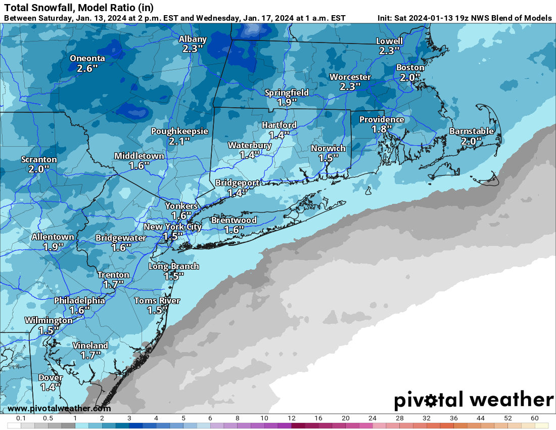
On to the 0Z models and the pendulum has definitely swung back a bit towards a snowier solution, with a solid 1-3" event starting to look likely and with potential for 3-5" and with 1" likely now the floor, since almost every model is now showing the precip starting several hours earlier, like somewhere between 10 pm Monday night and 2 am Tuesday, meaning the first part of the storm through rush hour should be all snow everywhere with temps in the 20s and accumulation on all untreated surfaces.One more 18Z model: the Euro came in a bit snowier than the last couple of runs, with 1-2" area wide on Tuesday with a few spots above 2", plus with cold temps (never above 32F except at the coast for a bit in the 33-34F range), we could see good ratios and won't see much melting.
This means we could easily have a quick inch or maybe 2" by the Tuesday am rush, which could make it a real mess. By late morning some models have warmer air moving in at the surface turning the precip to rain, especially from 95 SE to the coast, but others continue with the snow. Where it stays all snow 2-4" is looking likely. And anything that's on the ground by late afternoon on Tuesday might still be there through next weekend, with temps likely staying below 32F the whole week for folks NW of 95, which is even possible for 95/coast.
Specifically, we have the NAM with about 2-4" for everyone (and little rain), the RGEM with 2-4" just a bit NW of 95 and 1-2" for 95/coast, due to some rain around midday, the GFS a little snowier than 18Z with 1-2" for everyone (and this is the driest model right now), the CMC with a general 2-4" for everybody, and the UK with 3-5" along and NW of 95 and 1-3" towards the coast due to some rain and the Euro with 2-3" for everyone (was 1-2" at 18Z) and the ICON with 2-4" for 95 and NW and 1-2" SE of 95. The NWS blend of models has bumped up a bit to 1.5-2.5" for everyone.
We're now only a little bit more than 48 hours from these model initializations (7 pm tonight) to the start of the event, so the chance of major changes is dwindling rapidly, although it's still possible. The 1/19-20 potential storm is still possible, but as expected, 6+ days out, the models are all over the place. Beyond next weekend, the following week looks to be a bit warmer than normal followed by 1-2 weeks colder than normal, although temp patterns beyond 2 weeks are getting better, but are still somewhat unreliable.
Last edited:
Similar threads
- Replies
- 412
- Views
- 22K
ADVERTISEMENT
ADVERTISEMENT