
Yep, start time keeps moving up. Cherry Hill will likely start by 6-7 pm with accumulating snow (maybe some very light snow before that) and will largely be done with precip by 9-10 am or so, but 80-90% of that is going to be snow, with rain and/or maybe freezing rain likely only coming in after 6-7 am (if it does - only some models show that). You're going to have snow covered roads and the morning rush will likely be difficult.Last night, the forecast here in South Jersey was for snow to start 10 p.m. tonight; now the forecast is for a chance of snow this afternoon and then snow tonight without any stated starting time. That's quite a change. At least down here, the area is forecast to have snow, rain, and freezing rain in the mid-day hours tomorrow, so anyone in our area needs to be very cautious.
Colleges
- American Athletic
- Atlantic Coast
- Big 12
- Big East
- Big Ten
- Colonial
- Conference USA
- Independents (FBS)
- Junior College
- Mountain West
- Northeast
- Pac-12
- Patriot League
- Pioneer League
- Southeastern
- Sun Belt
- Army
- Charlotte
- East Carolina
- Florida Atlantic
- Memphis
- Navy
- North Texas
- Rice
- South Florida
- Temple
- Tulane
- Tulsa
- UAB
- UTSA
- Boston College
- California
- Clemson
- Duke
- Florida State
- Georgia Tech
- Louisville
- Miami (FL)
- North Carolina
- North Carolina State
- Pittsburgh
- Southern Methodist
- Stanford
- Syracuse
- Virginia
- Virginia Tech
- Wake Forest
- Arizona
- Arizona State
- Baylor
- Brigham Young
- Cincinnati
- Colorado
- Houston
- Iowa State
- Kansas
- Kansas State
- Oklahoma State
- TCU
- Texas Tech
- UCF
- Utah
- West Virginia
- Illinois
- Indiana
- Iowa
- Maryland
- Michigan
- Michigan State
- Minnesota
- Nebraska
- Northwestern
- Ohio State
- Oregon
- Penn State
- Purdue
- Rutgers
- UCLA
- USC
- Washington
- Wisconsin
High Schools
- Illinois HS Sports
- Indiana HS Sports
- Iowa HS Sports
- Kansas HS Sports
- Michigan HS Sports
- Minnesota HS Sports
- Missouri HS Sports
- Nebraska HS Sports
- Oklahoma HS Sports
- Texas HS Hoops
- Texas HS Sports
- Wisconsin HS Sports
- Cincinnati HS Sports
- Delaware
- Maryland HS Sports
- New Jersey HS Hoops
- New Jersey HS Sports
- NYC HS Hoops
- Ohio HS Sports
- Pennsylvania HS Sports
- Virginia HS Sports
- West Virginia HS Sports
ADVERTISEMENT
You are using an out of date browser. It may not display this or other websites correctly.
You should upgrade or use an alternative browser.
You should upgrade or use an alternative browser.
OT: Snow? - January 15-16?
- Thread starter Tango Two
- Start date
We had 3-5" for much of CNJ last winter including in NB (which had 3.3" last winter,; Metuchen had 5.2") so no streak of <1" snowfalls for some, unlike NYC which only had 2.3", likely due to the urban heat island effect there; NYC did have 1.5" of snow from one storm, but it was over 2 days, so the 1" wasn't exceeded on any calendar day (which is a little bit disingenous, IMO).Will this finally break the streak of no meaningful snow for CNJ? 600 days and counting. As I said before, it doesn't count if you don't have to shovel it. However, I will add to this and say, if snow cancels school that would break the streak as well.
Great thread, appreciate the insights from you and @Tango Two
Anyway, the entire CNJ area is very likely to get at least 2" and probably 3" or more and this will likely cancel or at least delay most schools, given below 32F temps through at least 7 am (and schools usually make their calls at 6 am - I know, as I've been consulted on potential snow related school closings in Metuchen for at least 15 years) and snow on all of the residential roads and most county roads, at least.

FYI, today's 12Z models are all showing a 2-4" event for almost the entire Philly-NJ-NYC region (maybe a bit less at the immediate coast in Ocean County and southward) and most of the models are showing pockets of 4-5" amounts, but in different locations (mostly NW of 95 though in EPA or NW NJ). Only the Euro to go. At this point, it's extremely unlikely the forecast will bust.
Last edited:
Looks like 2-4 across NJ is a safe bet.
We got none here last year in Monmouth county that I recall so our streak looks like it’ll be broken
What’s the status for the Thursday - Friday system?
We got none here last year in Monmouth county that I recall so our streak looks like it’ll be broken
What’s the status for the Thursday - Friday system?
The late Thursday into Friday system might have the highest uncertainty 4 days out in awhile, as models through last night have been showing anywhere from nada to several inches; however, today's 12Z GFS shows a 1-2" event and the CMC shows more like a 2-5" event; Euro and UK up soon - will start a thread if those also show some snow. There is likely to be a coastal low fairly far offshore, which normally would only bring light snow to the area (especially at the coast), but there are signals of an inverted trough feature forming and these can focus precip (snow here) well NW of the low. However, they’re notoriously difficult to forecast, as they often have a narrow area of heavy precip surrounded by areas of much lighter precip. The NWS had a nice write-up on this possible event this morning...Looks like 2-4 across NJ is a safe bet.
We got none here last year in Monmouth county that I recall so our streak looks like it’ll be broken
What’s the status for the Thursday - Friday system?
The period Thursday night through Friday still looks to be the most
challenging portion of the long term forecast as a series of
impulses continue to rotate around the base of the long wave trough
leading to the development of a coastal storm system developing to
our south and then moving off the coast. While this still has the
potential to bring the area a more significant snowfall event, there
is a lot of uncertainty in the forecast at this time. Generally
speaking though, forecast guidance looks to take the low fairly far
off the coast to our south and east as an initial wave moves through
while hanging back a surface trough towards the coast as a norlun
trough type set up. Convergence and precip may then be enhanced
along this feature as the main vort max aloft swings around. This is
a notoriously difficult situation for forecast models to resolve as
it can sometimes result in a relatively small/narrow areas of
heavier snowfall within a broader area of much lighter snow. Given
that this system is still several days out, we kept the forecast
close to the NBM (National Blend of Models) which brings in likely
POPs around 60 percent for Friday for the majority of the forecast
area (save for the southern Poconos). With the track of the system
off the coast and winds staying mainly N/NE we are confident any
precip should be mainly snow across the area except right near the
coast where some rain could mix in. As mentioned though, lot of
uncertainly on amounts. Expect highs Friday mainly in the upper 20s
to low 30s, except mid 30s near the coast and southern Delmarva and
low/mid 20s over the southern Poconos.

For the week!Will schools be canceled for tomorrow
Yup. 2 days minimum! Snow has become such an infrequent thing, we forgot how to handle it.given the timing with snow winding down in the morning its likely schools are closed. Will not be that wet sloppy snow like last week but more of the lighter powdery stuff so easier to sweep and remove
Here at the shore, the latest NWS says it will start after 5 p.m. and then mix with rain overnight. 1-2.5" is their call for South Monmouth near the coast.
I expect many to most to be closed with the rest likely having delayed openings. If it were 2-4" with marginal temps and not much on the roads, maybe most would be open, but schools usually are thinking about sidewalks, driveways and residential streets and those will all be covered and slippery with every flake that falls with temps below 32F at least through 7-8 am everywhere except well SE of 95.Will schools be canceled for tomorrow
i didnt have anything last year besides a dustingWe had 3-5" for much of CNJ last winter including in NB (which had 3.3" last winter,; Metuchen had 5.2") so no streak of <1" snowfalls for some, unlike NYC which only had 2.3", likely due to the urban heat island effect there; NYC did have 1.5" of snow from one storm, but it was over 2 days, so the 1" wasn't exceeded on any calendar day (which is a little bit disingenous, IMO).
Anyway, the entire CNJ area is very likely to get at least 2" and probably 3" or more and this will likely cancel or at least delay most schools, given below 32F temps through at least 7 am (and schools usually make their calls at 6 am - I know, as I've been consulted on potential snow related school closings in Metuchen for at least 15 years) and snow on all of the residential roads and most county roads, at least.
Pretty similar to here, with 2-4" forecast; just starts 4-6 hours earlier (4-5 pm) and will end by sunrise most likely.Dc forecast pls
https://www.weather.gov/lwx/

Wow, I wouldn't have thought being about 12 miles WSW from NB would make that much of a difference, but then again it went from 3.3" in NB to 5.2" in Metuchen over just 6 miles and with every system last year being marginal, small distances made bigger than usual differences.i didnt have anything last year besides a dusting
I never know how much trust we're supposed to put in what the NWS says on its page that gives its prognostication for a zip code, but what they are saying right now is contrary to what you are saying.Yep, start time keeps moving up. Cherry Hill will likely start by 6-7 pm with accumulating snow (maybe some very light snow before that) and will largely be done with precip by 9-10 am or so, but 80-90% of that is going to be snow, with rain and/or maybe freezing rain likely only coming in after 6-7 am (if it does - only some models show that). You're going to have snow covered roads and the morning rush will likely be difficult.
They continue, as I said, to forecast snow lasting until 10 tomorrow, then a combination of snow, rain, and (horrors) freezing rain until 1, and then snow and rain until 4.
https://forecast.weather.gov/MapClick.php?lat=39.90374000000003&lon=-74.96939999999995
The late Thursday into Friday system might have the highest uncertainty 4 days out in awhile, as models through last night have been showing anywhere from nada to several inches; however, today's 12Z GFS shows a 1-2" event and the CMC shows more like a 2-5" event; Euro and UK up soon - will start a thread if those also show some snow. There is likely to be a coastal low fairly far offshore, which normally would only bring light snow to the area (especially at the coast), but there are signals of an inverted trough feature forming and these can focus precip (snow here) well NW of the low. However, they’re notoriously difficult to forecast, as they often have a narrow area of heavy precip surrounded by areas of much lighter precip. The NWS had a nice write-up on this possible event this morning...
The period Thursday night through Friday still looks to be the most
challenging portion of the long term forecast as a series of
impulses continue to rotate around the base of the long wave trough
leading to the development of a coastal storm system developing to
our south and then moving off the coast. While this still has the
potential to bring the area a more significant snowfall event, there
is a lot of uncertainty in the forecast at this time. Generally
speaking though, forecast guidance looks to take the low fairly far
off the coast to our south and east as an initial wave moves through
while hanging back a surface trough towards the coast as a norlun
trough type set up. Convergence and precip may then be enhanced
along this feature as the main vort max aloft swings around. This is
a notoriously difficult situation for forecast models to resolve as
it can sometimes result in a relatively small/narrow areas of
heavier snowfall within a broader area of much lighter snow. Given
that this system is still several days out, we kept the forecast
close to the NBM (National Blend of Models) which brings in likely
POPs around 60 percent for Friday for the majority of the forecast
area (save for the southern Poconos). With the track of the system
off the coast and winds staying mainly N/NE we are confident any
precip should be mainly snow across the area except right near the
coast where some rain could mix in. As mentioned though, lot of
uncertainly on amounts. Expect highs Friday mainly in the upper 20s
to low 30s, except mid 30s near the coast and southern Delmarva and
low/mid 20s over the southern Poconos.
To summarize, for Friday, today's 12Z GFS shows a 1-2" event, the CMC shows more like a 2-5" event, the UK shows a 1-3" event (but only south of 78) and the Euro shows roughly a 2-4" event, so the 4 major global models are all showing a light to moderate event (not too different from what we're expecting tomorrow, although the snow is being generated in a completely different setup). Will start a thread sometime today, probably after the NWS update at 4 pm to include what they have to say.
YOu cant announce you're going to start a thread and not expect one of the savages to beat you to the punch. Come on....To summarize, for Friday, today's 12Z GFS shows a 1-2" event, the CMC shows more like a 2-5" event, the UK shows a 1-3" event (but only south of 78) and the Euro shows roughly a 2-4" event, so the 4 major global models are all showing a light to moderate event (not too different from what we're expecting tomorrow, although the snow is being generated in a completely different setup). Will start a thread sometime today, probably after the NWS update at 4 pm to include what they have to say.
Is there a special phone they gave you? Something like the bat phone where it blinks on and off?We had 3-5" for much of CNJ last winter including in NB (which had 3.3" last winter,; Metuchen had 5.2") so no streak of <1" snowfalls for some, unlike NYC which only had 2.3", likely due to the urban heat island effect there; NYC did have 1.5" of snow from one storm, but it was over 2 days, so the 1" wasn't exceeded on any calendar day (which is a little bit disingenous, IMO).
Anyway, the entire CNJ area is very likely to get at least 2" and probably 3" or more and this will likely cancel or at least delay most schools, given below 32F temps through at least 7 am (and schools usually make their calls at 6 am - I know, as I've been consulted on potential snow related school closings in Metuchen for at least 15 years) and snow on all of the residential roads and most county roads, at least.
Looks like they've extended the end time a bit further than what they were showing earlier and what some of the models are projecting after about 7-8 am. Some models have the precip over by 9-10 am for you and others by 1-2 pm, while the NWS has the precip winding down between 11 am and 4 pm with some rain and freezing rain possible, as you noted. It's not a big difference, really, since most of the snow damage is done by 9-10 am when temps for you are forecast to go above 32F just a little. Below is the hourly graphic for Cherry Hill. Hope that helps.I never know how much trust we're supposed to put in what the NWS says on its page that gives its prognostication for a zip code, but what they are saying right now is contrary to what you are saying.
They continue, as I said, to forecast snow lasting until 10 tomorrow, then a combination of snow, rain, and (horrors) freezing rain until 1, and then snow and rain until 4.
https://forecast.weather.gov/MapClick.php?lat=39.90374000000003&lon=-74.96939999999995
Yes and it's red for RU.Is there a special phone they gave you? Something like the bat phone where it blinks on and off?
Hmm, I haven't started a weather thread in a while? :)YOu cant announce you're going to start a thread and not expect one of the savages to beat you to the punch. Come on....
+1i didnt have anything last year besides a dusting
600 days and counting.
I truly don't care that much. I never did. People overreact when they see me explain why I prefer starting them, but to think I care more than a tiny bit is a little silly. Was nice to see the mods take out the trash last night, though - that I care a little more about as the trolling and bickering are annoying to most people. I have things to do this afternoon, so if someone else starts it, whatever...YOu cant announce you're going to start a thread and not expect one of the savages to beat you to the punch. Come on....
Wow - pretty early.Snow has begun in Cherry Hill. Fairly fine but consistent
I guess I spaced out on the timing of this one.It's right on schedule

Well... already at 6" here above Boone NC. I suspect the projected "snow total" of 4-8" needs to be adjusted, as it's supposed to snow until tomorrow midday. Thankfully, no wind, which is highly unusual for our mountain top during a snow event. Anyway, might have to brave it, get out there, and clear what I can away now vs waiting until it freezes solid over the next couple days.
IIRC, there are two "waves" of precip with this storm. Wave 1 is the southern special. Wave 2 is more north.I guess I spaced out on the timing of this one.
Actually wave 1 is really just a shortwave developed along the cold front leading to frontogenetic forcing from the clash of the cold front with the warm air its displacing and is northern stream derived, while wave 2 is a surface coastal that forms off NC then heads NE and is southern jet stream derived. Not an expert on synoptics though, so I might not have all of that correct, but that's essentially how Dr. Postell was explaining it today on TWC. Thought the NWS did a nice job describing this yesterday.IIRC, there are two "waves" of precip with this storm. Wave 1 is the southern special. Wave 2 is more north.
The Philadelphia snow drought appears to be near its end.
Relatively weak high pressure will be starting to give way to a
developing wave of low pressure along the stationary boundary to
our south Monday evening, with warm advection/isentropic lift
and frontogenesis already causing some light snow to break out
across the Delmarva and southern New Jersey. This light snow
will then overspread areas further north overnight. With
relatively modest forcing overall, expect rates to remain
relatively low, but widespread 1 to 2 inches of accumulation
looks reasonable by late Monday night across much of the area.
Temperatures will be mostly in the 20s through the night.
Tuesday, surface low strengthens as it passes northeastward off
the coast to our south. Some question remains about how close
the surface low passes, as some guidance sends a warm layer into
coastal areas which may change the immediate coast to rain
while possibly bringing some freezing rain to the I-95 corridor
Tuesday morning into midday. Further northwest, frontogenesis
and divergence aloft from the approaching upper level shortwave
likely leads to continued light but steady snowfall across the
Lehigh Valley and Poconos. Expect highest totals in these areas,
with locally more than 4 inches possible.
Looks like the pushed the totals up a little. I don't use the snow blower for anything less then 4". It's easier to just push it with a shovel IMO
So, the NWS upped snowfall amounts again, based on the uptick in snowfall on the models, with the advisories generally for 3-5" along and NW of 95 in EPA/NJ, north of 276/195 that's what the advisories say even though the map shows 4-6" - the next "color" is 3-4", so they had to pick one), with 2-4" south of there and SE of 95, except only 1-2" in far SENJ as per the updated map below. NWS-NYC updated map not out yet, but their advisories for NENJ (Union up to Bergen) and NYC/LI are for 2-4", so a little less than NJ/PA NW of 95 and N of 276/195. These are pretty minor differences and it's easily possible the max amounts are in NENJ or NYC.NWS issued winter weather advisories for the entire Philly and NYC office counties (advisory criterion is 3" for counties N of 195/276 and is 2" for counties south of that) and did up their snowfall forecast a bit, with areas generally north of 195/276 forecast to get 3-4" and areas south of there forecast to get 2-3", as those areas are most likely to change over to rain for a bit after sunrise on Tuesday. Also, areas from NYC eastward are also forecast to get 2-3" of snow (due to a bit less precip); maps are below. It's also worth noting that there is some risk of a changeover to sleet and/or freezing rain along and a bit SE of 95 on Tuesday morning after about sunrise, but this is only being seen on the mesoscale models (NAM/RGEM), so it's not "officially" in the forecast.
Most other sources are showing a 1-3"/2-4" snowfall forecast, so it's almost a lock that DC/Philly/NYC will break their 700+ day streaks of not getting 1" or more of snow on any calendar day (NYC did get 1.5" over 2 days in one storm last winter). Note that this snowfall will generally be light to moderate without much heavy snowfall, but even 1/4-1/2" or so per hour for 8-10 hours (say midnight to 10 am) would give 2-5". Also, the 6Z models this morning which just came out are just about all now showing a 2-4" event area wide, as reflected in the NBM (national blend of models) map below, although the NWS is a little bit more bullish than the NBM for CNJ/NNJ.
The snow start times keep moving up, so accumulating snow is now expected to start around 10-11 pm in CNJ/NNJ/NEPA and an hour or two earlier in Philly/SNJ and an hour or so later for NYC and areas NE of there. It will be all snow for the region through about sunrise on Tuesday with temps below 32F (in the mid/upper 20s except near the coast where temps will be closer to 32F), meaning snow will easily accumulate at night with cold temps, leading to very slippery roads everywhere for the Tues am rush hour, as all but treated/heavily traveled roads will likely be snow covered and visibility will be reduced; even the treated major roads will likely be a bit slushy with temps below 32F.
While temps might go a little above freezing during the late morning early afternoon (especially from 95 and SE of there), they'll quickly drop below 32F by late afternoon, so shoveling before sunset would be highly recommended, as temps might not go above 32F again until next Monday. There's also still the chance of another accumulating snowfall on Friday, but uncertainty on this one is huge, so it could be anywhere from nada to several inches - will start a new thread if warranted, soon.
https://www.weather.gov/phi/


Also, we'll see some light snow before 9-10 pm in CNJ, but it's likely we won't start seeing accumulations until after that. In addition, the NWS thinks there could be a change to sleet/freezing rain along the 95 corridor and probably even rain for coastal sections (hold accumulations down there) after about 9-10 am for a few hours, but that's not a given. Freezing rain would not be welcome, although it's better on top of snow than on top of bare pavement. Somewhere NW of 95, like Morris/Sussex/Passaic etc. might get to 5-6" if we see really fluffy ratios, which is possible where there is no mixing and they get good snow growth.
Still going with 3.2" for my house which is what I posted this morning, so I have to stick with it, but now thinking 4" is more likely given the updated forecasts and snowier models. We'll see soon.
https://forecast.weather.gov/wwamap/wwatxtget.php?cwa=PHI&wwa=winter weather advisory
Edit: NWS-NYC finally updated their map, below, also increasing snowfall amounts to 4-5" NW of the Parkway in NENJ and to 3-4" for east of the Parkway and NYC/LI.


Last edited:
NJZ001-007>010-012>015-161100-
/O.EXT.KPHI.WW.Y.0002.240115T2016Z-240116T2100Z/
Sussex-Warren-Morris-Hunterdon-Somerset-Middlesex-
Western Monmouth-Eastern Monmouth-Mercer-
Including the cities of Newton, Washington, Morristown,
Flemington, Somerville, New Brunswick, Freehold, Sandy Hook,
and Trenton
316 PM EST Mon Jan 15 2024
...WINTER WEATHER ADVISORY NOW IN EFFECT UNTIL 4 PM EST TUESDAY...
* WHAT...Mixed precipitation. Additional snow accumulations of 3
to 5 inches and ice accumulations of a light glaze.
* WHERE...Portions of central, northern and northwest New Jersey.
* WHEN...Until 4 PM EST Tuesday.
* IMPACTS...Plan on slippery road conditions. The hazardous
conditions could impact the morning or evening commute.
* ADDITIONAL DETAILS...The heaviest snow will fall tonight before
changing to a wintry mix of snow, sleet, and freezing rain
Tuesday morning. A period of plain rain is possible Tuesday
morning before mixing with snow and tapering off Tuesday
afternoon.
PRECAUTIONARY/PREPAREDNESS ACTIONS...
Slow down and use caution while traveling.
The latest road conditions for the state you are calling from can
be obtained by calling 5 1 1.
000
WWUS41 KPHI 152016
WSWPHI
URGENT - WINTER WEATHER MESSAGE
National Weather Service Mount Holly NJ
316 PM EST Mon Jan 15 2024
DEZ003-160900-
/O.EXB.KPHI.WW.Y.0002.240115T2016Z-240116T0900Z/
Inland Sussex-
Including the city of Georgetown
316 PM EST Mon Jan 15 2024
...WINTER WEATHER ADVISORY IN EFFECT UNTIL 4 AM EST TUESDAY...
* WHAT...Snow, changing to sleet and freezing rain this evening.
Additional snow accumulations of up to one inch and ice
accumulations of a light glaze.
* WHERE...Inland Sussex.
* WHEN...Until 4 AM EST Tuesday.
* IMPACTS...Plan on slippery road conditions. The hazardous
conditions could impact the evening commute.
* ADDITIONAL DETAILS...Wintry mix changes to rain before tapering
off late tonight.
PRECAUTIONARY/PREPAREDNESS ACTIONS...
Slow down and use caution while traveling.
The latest road conditions for the state you are calling from can
be obtained by calling 5 1 1.
&&
$$
NJZ023>025-161100-
/O.EXB.KPHI.WW.Y.0002.240115T2016Z-240116T1800Z/
Cape May-Atlantic Coastal Cape May-Coastal Atlantic-
Including the cities of Cape May Court House, Ocean City,
and Atlantic City
316 PM EST Mon Jan 15 2024
...WINTER WEATHER ADVISORY IN EFFECT UNTIL 1 PM EST TUESDAY...
* WHAT...Snow, changing to sleet and freezing rain late tonight.
Additional snow accumulations of 1 to 2 inches and ice
accumulations of a light glaze.
* WHERE...Cape May, Atlantic Coastal Cape May and Coastal
Atlantic.
* WHEN...Until 1 PM EST Tuesday.
* IMPACTS...Plan on slippery road conditions. The hazardous
conditions could impact the morning or evening commute.
* ADDITIONAL DETAILS...Wintry mix changes to rain Tuesday morning
before tapering off in the afternoon.
PRECAUTIONARY/PREPAREDNESS ACTIONS...
Slow down and use caution while traveling.
The latest road conditions for the state you are calling from can
be obtained by calling 5 1 1.
&&
$$
DEZ002-MDZ012-015-019-020-160900-
/O.EXT.KPHI.WW.Y.0002.240115T2016Z-240116T0900Z/
Kent-Kent MD-Queen Annes-Talbot-Caroline-
Including the cities of Dover, Chestertown, Centreville, Easton,
and Denton
316 PM EST Mon Jan 15 2024
...WINTER WEATHER ADVISORY NOW IN EFFECT UNTIL 4 AM EST TUESDAY...
* WHAT...Mixed precipitation. Additional snow accumulations of 1
to 3 inches and ice accumulations of a light glaze.
* WHERE...In Delaware, Kent. In Maryland, Kent MD, Queen Annes,
Talbot and Caroline.
* WHEN...Until 4 AM EST Tuesday.
* IMPACTS...Plan on slippery road conditions. The hazardous
conditions could impact the evening commute.
* ADDITIONAL DETAILS...Wintry mix may briefly change to plain
rain late tonight before changing back to a wintry mix before
tapering off Tuesday morning.
PRECAUTIONARY/PREPAREDNESS ACTIONS...
Slow down and use caution while traveling.
The latest road conditions for the state you are calling from can
be obtained by calling 5 1 1.
&&
$$
DEZ001-NJZ016>022-026-027-161100-
/O.EXT.KPHI.WW.Y.0002.240115T2016Z-240116T1800Z/
New Castle-Salem-Gloucester-Camden-Northwestern Burlington-Ocean-
Cumberland-Atlantic-Coastal Ocean-Southeastern Burlington-
Including the cities of Wilmington, Pennsville, Glassboro,
Camden, Cherry Hill, Moorestown, Mount Holly, Jackson, Millville,
Hammonton, Long Beach Island, and Wharton State Forest
316 PM EST Mon Jan 15 2024
...WINTER WEATHER ADVISORY NOW IN EFFECT UNTIL 1 PM EST TUESDAY...
* WHAT...Mixed precipitation. Additional snow accumulations of 2
to 4 inches and ice accumulations of a light glaze.
* WHERE...Portions of northern Delaware and southern New Jersey.
* WHEN...Until 1 PM EST Tuesday.
* IMPACTS...Plan on slippery road conditions. The hazardous
conditions could impact the morning or evening commute.
* ADDITIONAL DETAILS...Heaviest snow this evening. Snow becomes a
wintry mix after midnight and may briefly change to plain rain
Tuesday morning before tapering off.
PRECAUTIONARY/PREPAREDNESS ACTIONS...
Slow down and use caution while traveling.
The latest road conditions for the state you are calling from can
be obtained by calling 5 1 1.
&&
I think the NWS messed up on this a bit, as none of their point and click forecasts shows any mix N of 78 and NW of 287 or even 10-20 miles NW of 95 and south of 78 a bit and certainly not in Warren/Morris/Sussex/Hunterdon. Sure a mix might be seen after 9-10 am in much of Middlesex/Somerset/Mercer and SE of there.NJZ001-007>010-012>015-161100-
/O.EXT.KPHI.WW.Y.0002.240115T2016Z-240116T2100Z/
Sussex-Warren-Morris-Hunterdon-Somerset-Middlesex-
Western Monmouth-Eastern Monmouth-Mercer-
Including the cities of Newton, Washington, Morristown,
Flemington, Somerville, New Brunswick, Freehold, Sandy Hook,
and Trenton
316 PM EST Mon Jan 15 2024
...WINTER WEATHER ADVISORY NOW IN EFFECT UNTIL 4 PM EST TUESDAY...
* WHAT...Mixed precipitation. Additional snow accumulations of 3
to 5 inches and ice accumulations of a light glaze.
* WHERE...Portions of central, northern and northwest New Jersey.
* WHEN...Until 4 PM EST Tuesday.
* IMPACTS...Plan on slippery road conditions. The hazardous
conditions could impact the morning or evening commute.
* ADDITIONAL DETAILS...The heaviest snow will fall tonight before
changing to a wintry mix of snow, sleet, and freezing rain
Tuesday morning. A period of plain rain is possible Tuesday
morning before mixing with snow and tapering off Tuesday
afternoon.
PRECAUTIONARY/PREPAREDNESS ACTIONS...
Slow down and use caution while traveling.
The latest road conditions for the state you are calling from can
be obtained by calling 5 1 1.
Thanks for posting the updated map (and being first to do so). Lots of copycats in this thread.Looks like the pushed the totals up a little. I don't use the snow blower for anything less then 4". It's easier to just push it with a shovel IMO
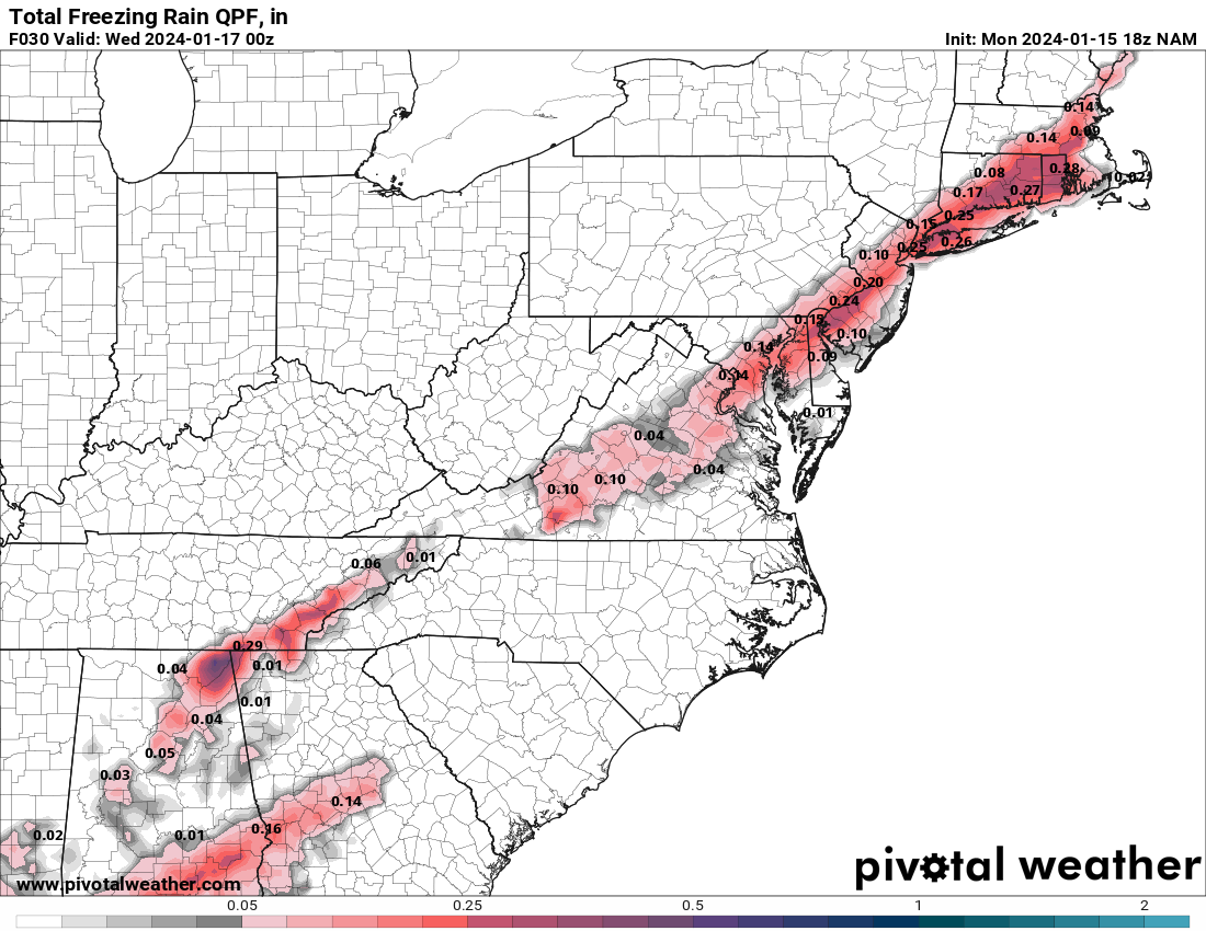
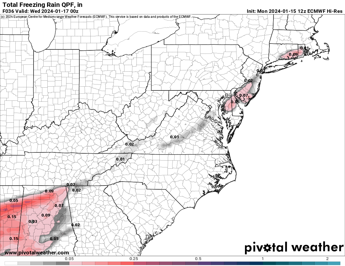
NAM and RGEM have consistently shown that freezing rain risk after about 9 am or so, but the globals either have all snow for 95 or a later changover to sleet or freezing rain. Agree we don't want freezing rain, as it's dangerous and aesthetically unpleasing. Saving grace could be that it'll mostly be falling on top of snow, forming a crust and not falling on bare ground forming ice rinks. Here's the difference between the NAM and Euro on freezing rain (ZR), which is substantial. If the NAM verified, that's 1-2" of snowfall lost to ZR and a risk of serious icing. Let's hope it's wrong.NAM has freezing rain for central jersey tomorrow morning so hopefully its dead wrong...dont want that after 2-4 inches and temps not budging much above mid 30s this week
Last edited:
Yep, Morristown totals bumped up from 3.5 to 5 inches in the last day, as per weather.gov.So, the NWS upped snowfall amounts again, based on the uptick in snowfall on the models, with the advisories generally for 3-5" along and NW of 95 in EPA/NJ, north of 276/195 that's what the advisories say even though the map shows 4-6" - the next "color" is 3-4", so they had to pick one), with 2-4" south of there and SE of 95, except only 1-2" in far SENJ as per the updated map below. NWS-NYC updated map not out yet, but their advisories for NENJ (Union up to Bergen) and NYC/LI are for 2-4", so a little less than NJ/PA NW of 95 and N of 276/195. These are pretty minor differences and it's easily possible the max amounts are in NENJ or NYC.
Also, we'll see some light snow before 9-10 pm in CNJ, but it's likely we won't start seeing accumulations until after that. In addition, the NWS thinks there could be a change to sleet/freezing rain along the 95 corridor and probably even rain for coastal sections (hold accumulations down there) after about 9-10 am for a few hours, but that's not a given. Freezing rain would not be welcome, although it's better on top of snow than on top of bare pavement. Somewhere NW of 95, like Morris/Sussex/Passaic etc. might get to 5-6" if we see really fluffy ratios, which is possible where there is no mixing and they get good snow growth.
Still going with 3.2" for my house which is what I posted this morning, so I have to stick with it, but now thinking 4" is more likely given the updated forecasts and snowier models. We'll see soon.
https://forecast.weather.gov/wwamap/wwatxtget.php?cwa=PHI&wwa=winter weather advisory
Edit: NWS-NYC finally updated their map, below, also increasing snowfall amounts to 4-5" NW of the Parkway in NENJ and to 3-4" for east of the Parkway and NYC/LI.
Similar threads
- Replies
- 412
- Views
- 22K
ADVERTISEMENT
ADVERTISEMENT