That stretch is not representative of the majority of the city...there are some nice places to eat in the vicinity of that stretch tho.From the Amtrak Train Station up Market Street to Rodney Square. Over to the TD Bank and back down another street to get to Frawley Stadium area where we all met up. The bike trail starts there. Streets in town were super clean. Not a bum to be found. Not many people in general like most business districts during Covid.
Bike trail all the way down to Chesapeake City was impressive.


Colleges
- American Athletic
- Atlantic Coast
- Big 12
- Big East
- Big Ten
- Colonial
- Conference USA
- Independents (FBS)
- Junior College
- Mountain West
- Northeast
- Pac-12
- Patriot League
- Pioneer League
- Southeastern
- Sun Belt
- Army
- Charlotte
- East Carolina
- Florida Atlantic
- Memphis
- Navy
- North Texas
- Rice
- South Florida
- Temple
- Tulane
- Tulsa
- UAB
- UTSA
- Boston College
- California
- Clemson
- Duke
- Florida State
- Georgia Tech
- Louisville
- Miami (FL)
- North Carolina
- North Carolina State
- Pittsburgh
- Southern Methodist
- Stanford
- Syracuse
- Virginia
- Virginia Tech
- Wake Forest
- Arizona
- Arizona State
- Baylor
- Brigham Young
- Cincinnati
- Colorado
- Houston
- Iowa State
- Kansas
- Kansas State
- Oklahoma State
- TCU
- Texas Tech
- UCF
- Utah
- West Virginia
- Illinois
- Indiana
- Iowa
- Maryland
- Michigan
- Michigan State
- Minnesota
- Nebraska
- Northwestern
- Ohio State
- Oregon
- Penn State
- Purdue
- Rutgers
- UCLA
- USC
- Washington
- Wisconsin
High School
- Illinois HS Sports
- Indiana HS Sports
- Iowa HS Sports
- Kansas HS Sports
- Michigan HS Sports
- Minnesota HS Sports
- Missouri HS Sports
- Nebraska HS Sports
- Oklahoma HS Sports
- Texas HS Hoops
- Texas HS Sports
- Wisconsin HS Sports
- Cincinnati HS Sports
- Delaware
- Maryland HS Sports
- New Jersey HS Hoops
- New Jersey HS Sports
- NYC HS Hoops
- Ohio HS Sports
- Pennsylvania HS Sports
- Virginia HS Sports
- West Virginia HS Sports
ADVERTISEMENT
Install the app
How to install the app on iOS
Follow along with the video below to see how to install our site as a web app on your home screen.
Note: This feature may not be available in some browsers.
You are using an out of date browser. It may not display this or other websites correctly.
You should upgrade or use an alternative browser.
You should upgrade or use an alternative browser.
OT: Snow Thread For Feb 6th & 7th Super Bowl Sunday
- Thread starter Tango Two
- Start date

Did everyone survive the snow shower?
Barely survived the 20-30 mins of rain. Sun in and out, Temp around 40.
Oh the humanity huh?
Where are you? It's raining in Monroe twp.
Union/Morris County line - just north of 78.
As said above - it was coming down pretty hard.
Roads weren't terrible but a little slippery - saw one car went off the road.
All melted now luckily.
I did pass a few places on Market Street that looked great but it was in the morning so nothing was open. The other town that surprised me was New Castle. Thought it was a bigger modern city but it's a beautiful small historic town.That stretch is not representative of the majority of the city...there are some nice places to eat in the vicinity of that stretch tho.
So far, every 12Z model (NAM/RGEM mesoscale models and the GFS, CMC, and UK global models) is coming in hot for Sunday, with a general 4-8" for Philly-NJ-NYC (and up to 10" in some locations), with the heaviest precip still along the coast and a bit less well inland of 95 (but still enough for several inches of snow, which was not the case before today); there's also still the chance of mixing/changeover for the coast as warmer air moves. Still waiting for the Euro.
Since we're now within 48 hours of the start of the event (from the 7 am model initialization today), i would think the NWS would want to see some continuity from the models (i.e., seeing similar outcomes tonight) before issuing winter storm watches, but if we see that continuity, I would think we'd see watches issued with the 4 am NWS updates.
Edit: Euro also on board with 4-6" for the 95 corridor, 6-8" towards the coast and 2-4" N/W of 95 by a bit. Sunday looks pretty snowy now.
I'd also add that the chances of a complete whiff for everyone just went to near zero, but it's still possible that this is mostly a coastal snowstorm 4-8" or more near/along the coast, but with only a few inches along 95 and little well inland, if the storm tracks SE of the current projections and, on the other hand, it's still possible the track shifts further NW, which would likely lead to some rain/mixing along the coast, holding snowfall down significantly, while bringing 4-8" (and up to 10") to everyone along and NW of 95 (with 95 being the battlground for mixing).
Last edited:
Are we talking morning or starting later in the day in Middlesex County?So far, every 12Z model (NAM/RGEM mesoscale models and the GFS, CMC, and UK global models) is coming in hot for Sunday, with a general 4-8" for Philly-NJ-NYC (and up to 10" in some locations), with the heaviest precip still along the coast and a bit less well inland of 95 (but still enough for several inches of snow, which was not the case before today); there's also still the chance of mixing/changeover for the coast as warmer air moves. Still waiting for the Euro.
Since we're now within 48 hours of the start of the event (from the 7 am model initialization today), i would think the NWS would want to see some continuity from the models (i.e., seeing similar outcomes tonight) before issuing winter storm watches, but if we see that continuity, I would think we'd see watches issued with the 4 am NWS updates.
this looks to come in at 3-4 am timeframe Sunday morning and be done by late afternoon
since the other thread was locked...somehow the south brunswick snow totals were revised up. the SBPD was reporting 11.5" or so and an email came out today saying that Weather Works reported 18" for the town.
The Philadelphia Inquirer reports that the NWS is boosting the amount of snow expected in Philly. But the NWS has not changed the forecast of 1-3 inches for my area of Cherry Hill. I suspect the Inquirer story is mostly hype to attract eyeballs and that the greater amount will fall mainly north and west of the city as it almost always does. https://www.inquirer.com/weather/sn...ecast-sunday-winter-storm-pa-nj-20210205.html
since the other thread was locked...somehow the south brunswick snow totals were revised up. the SBPD was reporting 11.5" or so and an email came out today saying that Weather Works reported 18" for the town.
Yeah, when I saw 11.5 the other day, I thought they got it totally wrong considering I measured 17. But I just did it on my deck.
Yeah, when I saw 11.5 the other day, I thought they got it totally wrong considering I measured 17. But I just did it on my deck.
I "liked" your post simply on the basis of the message on the bottom. We ought to think of a team for the nasty posters to follow so that they get off this board.
camden - you have to realize that the NWS doesn't change forecasts quickly before a storm - they usually only do forecast updates at 4 am and 4 pm every day, so 2-4" was a decent guess for you this morning (NWS is not 1-3" for you right now - in fact, your point/click forecast is for just shy of 3"), but 4-6" (dark blue) will be what you likely see at 4 pm today from the NWS. I don't think they'll go as high as 6-8" (the yellow color), which every model is showing for Camden, just because I think they're going to want to see more continuity on model runs through tonight.The Philadelphia Inquirer reports that the NWS is boosting the amount of snow expected in Philly. But the NWS has not changed the forecast of 1-3 inches for my area of Cherry Hill. I suspect the Inquirer story is mostly hype to attract eyeballs and that the greater amount will fall mainly north and west of the city as it almost always does. https://www.inquirer.com/weather/sn...ecast-sunday-winter-storm-pa-nj-20210205.html
Prelim info from WW:its funny how a storm like this gets such a low profile after we just had 14-28 incher
Overcast with snow more likely in the morning, with light to moderate intensities through the day, becoming intermittent/lighter in the afternoon. Snow can mix back with some rain/sleet as it lightens.
Storm is trending NW, Preliminary Accumulation 1.5 - 3.5"
High in the mid 30s (can cool under any snow).
The most important question that will determine the impact of this storm is: Has the Weather Channel named the storm yet?
Brady
Is this for France? Thailand? Somewhere in NJ? If you truly want to be helpful, add a little more detail and a link or map. This post is useless.Prelim info from WW:
Overcast with snow more likely in the morning, with light to moderate intensities through the day, becoming intermittent/lighter in the afternoon. Snow can mix back with some rain/sleet as it lightens.
Storm is trending NW, Preliminary Accumulation 1.5 - 3.5"
High in the mid 30s (can cool under any snow).
Numbers you think 4-8 for central jersey ?Is this for France? Thailand? Somewhere in NJ? If you truly want to be helpful, add a little more detail and a link or map. This post is useless.
If I had to guess right now, I'd guess 3-6", hedging just a bit on the up to 8" part, since we haven't seen any consensus until the 12Z runs today and I want to see another model cycle be consistent before committing to 4-8". We also need to consider the 1-3/2-4" possibility if the track is more offshore. But yeah, right now I'd go with 3-6", knowing the likely range includes 2-4" to 4-8" (and even up to 10" is possible).Numbers you think 4-8 for central jersey ?
Edit: the brand new 18Z NAM is 6-10" for the entire state of NJ (except less in far SE NJ i.e., SE of a Millville to LBI line, due to mixing, but even they get several inches) all of nearby eastern PA and all of NYC metro/LI/SENY/CT. This shows the likely ceiling if we get a "perfect" track, which is not a given.
Last edited:
I think 3-6 is a safe call..and the c9ast could get mixing issue
What an overperforming melting day today..almost springlike..50!
What an overperforming melting day today..almost springlike..50!
Last edited:
Reply and message to Bac. He knows the location. Mind your own business. :)Is this for France? Thailand? Somewhere in NJ? If you truly want to be helpful, add a little more detail and a link or map. This post is useless.
Well, I clearly guessed wrong on the NWS in both Philly and NYC as they just issues watches for most of the area (except NWNJ/NEPA and SE NY north of the Tappan Zee) for 5" or more of snow just now, not waiting for 4 am - maybe they were looking at the 18Z NAM, lol. See the map for counties in blue with watches - those watches might easily extend NW if we see more consensus on heavier snows to the NW. NWS-Philly also put out a snowfall map, below (not yet for NWS-NYC).If I had to guess right now, I'd guess 3-6", hedging just a bit on the up to 8" part, since we haven't seen any consensus until the 12Z runs today and I want to see another model cycle be consistent before committing to 4-8". We also need to consider the 1-3/2-4" possibility if the track is more offshore. But yeah, right now I'd go with 3-6", knowing the likely range includes 2-4" to 4-8" (and even up to 10" is possible).
Edit: the brand new 18Z NAM is 6-10" for the entire state of NJ (except less in far SE NJ i.e., SE of a Millville to LBI line, due to mixing, but even they get several inches) all of nearby eastern PA and all of NYC metro/LI/SENY/CT. This shows the likely ceiling if we get a "perfect" track, which is not a given.
https://www.weather.gov/phi/
5 pm edit: the NWS-NYC also just posted their snowfall map, which is similar to the NWS-Philly...
Last edited:
I really don't see 7 inches for this but we shall see
Its over by late afternoon and even early afternoon for western sections
Its over by late afternoon and even early afternoon for western sections
+1I really don't see 7 inches for this but we shall see
Its over by late afternoon and even early afternoon for western sections
Another storm, another bust by NWS. Their wishcasting and hype are ridiculous.
The 12z afternoon run of the euro joins other models in showing a quick hitting snowstorm for Sunday. Snow totals will generally range in the 3-6 inch range away from the coast to 4-8+ in the heavier banding which currently is projected to be at the coast from coastal NJ thru Long Island to southern Rhode Island.

Prelim info from WW:
Overcast with snow more likely in the morning, with light to moderate intensities through the day, becoming intermittent/lighter in the afternoon. Snow can mix back with some rain/sleet as it lightens.
Storm is trending NW, Preliminary Accumulation 1.5 - 3.5"
High in the mid 30s (can cool under any snow).
I probably shouldn't ask this, but why are you so high on WW? Do you think they somehow have different and better sources of information?
They don't. They had the best forecast for the 12/16 event, but missed this one for most, doing much worse than the NWS-Philly and NYC and have missed more than a few in the past. I think the NWS over the last 20 years has been better, but will admit that WW has been better the past 2-3 years, as the NWS-Philly (not the NWS-NYC, which has done better) has just struggled. The fact that he's afraid to post their maps/info should be a red flag.I probably shouldn't ask this, but why are you so high on WW? Do you think they somehow have different and better sources of information?
That's what she said?I really don't see 7 inches for this but we shall see
I thought the ceiling for this was 10-12" and still do, but the 18Z 3km NAM has to make emergency planners a little nervous (shows 12-18" for most) - it's an outlier and likely overdone, but we have to see how this evolves to be sure.I really don't see 7 inches for this but we shall see
Its over by late afternoon and even early afternoon for western sections
The NWS forecast was great for the storm earlier this week and way better than WW's, which was well underdone for everyone outside of Mercer and far southern Somerset/Middlesex.+1
Another storm, another bust by NWS. Their wishcasting and hype are ridiculous.
Yes, they are the best in the business. And I'm talking about their paid service that my town and many in the area use to plan for storms, plowing, and events for DPW (public works). They have been remarkably accurate for the past 3-4 years. No hype, no wishcasting, just solid forecasts.I probably shouldn't ask this, but why are you so high on WW? Do you think they somehow have different and better sources of information?
Ask Bac, he knows as well.
I thought the ceiling for this was 10-12" and still do, but the 18Z 3km NAM has to make emergency planners a little nervous (shows 12-18" for most) - it's an outlier and likely overdone, but we have to see how this evolves to be sure.
18zGFS and RGEM look further east
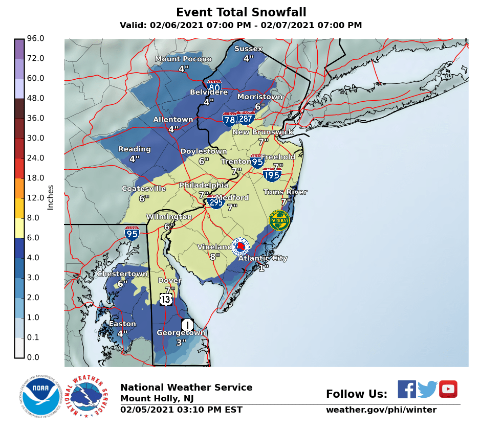
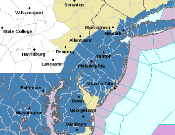
Nice write-up by NWS-Mt. Holly on the storm. They do mention the chance for 8-12" in some areas wherever the heaviest deformation bands set up (impossible to predict this far out or even 6 hours in advance, really).Well, I clearly guessed wrong on the NWS in both Philly and NYC as they just issues watches for most of the area (except NWNJ/NEPA and SE NY north of the Tappan Zee) for 5" or more of snow just now, not waiting for 4 am - maybe they were looking at the 18Z NAM, lol. See the map for counties in blue with watches - those watches might easily extend NW if we see more consensus on heavier snows to the NW. NWS-Philly also put out a snowfall map, below (not yet for NWS-NYC).
https://www.weather.gov/phi/
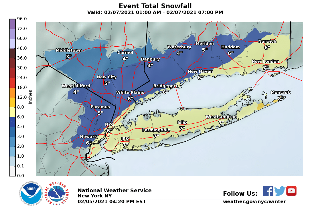
5 pm edit: the NWS-NYC also just posted their snowfall map, which is similar to the NWS-Philly...
https://forecast.weather.gov/produc...&format=CI&version=1&glossary=1&highlight=off
National Weather Service Mount Holly NJ
419 PM EST Fri Feb 5 2021
SHORT TERM /SATURDAY NIGHT THROUGH MONDAY/...
The main story for this period will be the coastal storm as it
moves up the coast Sunday.
To start the period Saturday evening low pressure will be developing
near the Gulf coast in response to shortwave energy diving south to
near the base of the long wave trough. Meanwhile weak ridging will
still be present across the mid Atlantic though there will already
be some increasing mid and high cloudiness but it will be dry.
The system will start moving up the coast through Saturday night
with low pressure located near or just east of Cape Hatteras by
12z Sunday. Similar to many systems in recent years, the main
question will be the exact track and strength of the low. One of
the determining factors influencing this will be how much
phasing occurs between two pieces of shortwave energy...the main
one rounding the base of the trough over the SE then moving up
the coast with another piece of energy diving SE through the
midwest. The general trend has been for a stronger system
tracking farther north and west with the NAM being the strongest
while the GFS is still be a bit weaker and farther S/E. However
GFS trend has also generally been N/W with time. Given the
model trend and also that the models are sometimes a bit slow to
catch on to rapid self development of coastal storms we have
increased QPF and snow amounts and issued a Winter Storm for a
fairly broad swatch of the CWA excluding our NW zones and
Atlantic coastal areas from Atlantic County southward.
In terms of sensible weather with the storm, expect snow to develop
SW to NE near or shortly after midnight Saturday night. The precip
could start as rain over southern Delmarva and parts of southern NJ
but as cooling effects take hold it will change to all snow. The
brunt of the storm looks to hit into Sunday morning as deepening low
pressure tracks northeast off the coast. There should be strong
forcing for ascent over the area due to right jet entrance dynamics
and also the mid level low looks to track right near the area as it
start to close off. The upshot is we expect snow, heavy at times,
through the morning with still some question on exactly where the
heaviest bands set up. Heaviest bands of snow will likely be near or
just north of the mid level low in the strongest F-Gen forcing.
Rates in the heaviest bands are likely to be 1-2 inches per
hour creating significantly reduced visibility. Most of the
forecast area should be all snow Sunday with the exception being
southern Delmarva and parts of coastal NJ where a mix with or
change to rain and sleet will be possible. But this will depend
on the exact track of the storm. A track closer to the coast
will result in more mixing near the coast with the heaviest snow
near or even north of I-95 while a track farther east will
result in mostly all snow even at the coast potentially bringing
the highest snow amounts here. Generally favoring a track close
enough to the coast to bring at least some mixing here with our
highest snow amounts of 6+ inches currently forecast in a swath
near the I-95 corridor. But again, confidence still fairly low
on these exact details despite growing confidence of the storm
impacting the region. Also, within the area we are currently
forecasting 6-8 inches there will likely be an area that gets
8-12+ inches in the heaviest bands.
So just to be clear with no questions. NWS is calling for 7" for Philly correct?Well, I clearly guessed wrong on the NWS in both Philly and NYC as they just issues watches for most of the area (except NWNJ/NEPA and SE NY north of the Tappan Zee) for 5" or more of snow just now, not waiting for 4 am - maybe they were looking at the 18Z NAM, lol. See the map for counties in blue with watches - those watches might easily extend NW if we see more consensus on heavier snows to the NW. NWS-Philly also put out a snowfall map, below (not yet for NWS-NYC).
https://www.weather.gov/phi/
5 pm edit: the NWS-NYC also just posted their snowfall map, which is similar to the NWS-Philly...
Similar threads
- Replies
- 62
- Views
- 2K
- Replies
- 592
- Views
- 16K
OT: Minor to Moderate (2-4?) Snowfall Likely Sat morning (2/17); will be <32F, so expect slick roads
- Replies
- 213
- Views
- 5K
- Replies
- 608
- Views
- 18K
- Replies
- 771
- Views
- 20K
ADVERTISEMENT
ADVERTISEMENT