True. And I really like when she says "but we shall see". So promising sounding. 😁That's what she said?

ADVERTISEMENT
You are using an out of date browser. It may not display this or other websites correctly.
You should upgrade or use an alternative browser.
You should upgrade or use an alternative browser.
OT: Snow Thread For Feb 6th & 7th Super Bowl Sunday
- Thread starter Tango Two
- Start date

+1So just to be clear with no questions. NWS is calling for 7" for Philly correct?
Get it on the record.
Yes don't want to hear I'm using the wrong map.+1
Get it on the record.

The 12z afternoon run of the euro joins other models in showing a quick hitting snowstorm for Sunday. Snow totals will generally range in the 3-6 inch range away from the coast to 4-8+ in the heavier banding which currently is projected to be at the coast from coastal NJ thru Long Island to southern Rhode Island.

18zGFS and RGEM look further east
Yes, that is their current forecast, subject to change, since the forecast was made 36 hours before flakes start flying in the Philly area. Just keep that in mind, as every forecaster will normally make changes between 48 and 24 hours (or even 12 hours) in advance of the storm, since it's an inexact science and things change. For example, for the last storm, 48 hrs before the event start, the NWS prediction for Philly was 7", which went up to 10" 36 hrs before the event and then 12" 24 hrs before the event and stayed at 11-12" for the rest of the event and Philly got 8-10".So just to be clear with no questions. NWS is calling for 7" for Philly correct?
So what is the cutoff time, last call for a "forecast" ?Yes, that is their current forecast, subject to change, since the forecast was made 36 hours before flakes start flying in the Philly area. Just keep that in mind, as every forecaster will normally make changes between 48 and 24 hours (or even 12 hours) in advance of the storm, since it's an inexact science and things change. For example, for the last storm, 48 hrs before the event start, the NWS prediction for Philly was 7", which went up to 10" 36 hrs before the event and then 12" 24 hrs before the event and stayed at 11-12" for the rest of the event and Philly got 8-10".
Once the system arrives its an observation not a forecast. Midnight Saturday is the cutoff.
7.7 isn't 8-10 just saying 😂 and that "forecast" was after the storm began.
Today was fantastic. Tomorrow maybe a bike ride to the shore.
Last edited:
Current snowfall forecast. This is a fast mover. It will be in Sunday morning and out Sunday night. A general 4-8 inches is likely.

Happy National Weatherperson's Day!
On February 5, we commemorate the birth of John Jeffries, who was a Boston physician & one of America's first weather observers.

On February 5, we commemorate the birth of John Jeffries, who was a Boston physician & one of America's first weather observers.

Great question - depends who you ask. Most forecasters think their forecasts about 12 hours before the start of the event are what they should be assessed on, as that's usually enough time for anyone to plan on (especially if they're not far from their forecasts 24-48 hrs out). For the last storm, that was 11" for Philly from the NWS about 9-12 hrs before the start. Doesn't mean they won't still update their forecasts closer to the start and even after, as people need to know if there are changes. So for this storm, which should be starting in the 4 am-7 am range for Philly, the forecast tomorrow late afternoon/early evening is what I would measure them against.So what is the cutoff time, last call for a "forecast" ?
Once the system arrives its an observation not a forecast. Midnight Saturday is the cutoff.
7.7 isn't 8-10 just saying 😂 and that "forecast" was after the storm began.
Today was fantastic. Tomorrow maybe a bike ride to the shore.
Also, Philly had 6 measurements between 7.7 and 10.0" (the 6.9" measurement was too early IMO, as it likely missed an inch or so that fell), including 8.1" at the airport, hence my 8-10" comment. The airport is the location of record for Philly - and is often the lowest snowfall in the city, being in the far southern part of the city at its lowest elevation, also. It was actually a bad place to put the location of record - somewhere like Hunting Park would've been far better, as it's centrally located. It's why NYC's Central Park is a pretty good spot for the location of record for NYC.
What does this have to do with snow on Sunday? Nobody is worried about sun angles on Feb 8th.
While taking a day to celebrate the men and women of meteorology, can we also take a moment to celebrate us, the people who put up with meteorologist's (and weather hobbyist's) unrelenting need to communicate useful and interesting weather-related information in a timely and pleasant manner?Happy National Weatherperson's Day!
On February 5, we commemorate the birth of John Jeffries, who was a Boston physician & one of America's first weather observers.
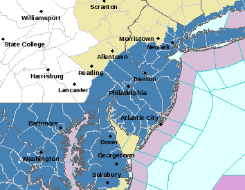
Well, I clearly guessed wrong on the NWS in both Philly and NYC as they just issues watches for most of the area (except NWNJ/NEPA and SE NY north of the Tappan Zee) for 5" or more of snow just now, not waiting for 4 am - maybe they were looking at the 18Z NAM, lol. See the map for counties in blue with watches - those watches might easily extend NW if we see more consensus on heavier snows to the NW. NWS-Philly also put out a snowfall map, below (not yet for NWS-NYC).
https://www.weather.gov/phi/
5 pm edit: the NWS-NYC also just posted their snowfall map, which is similar to the NWS-Philly...
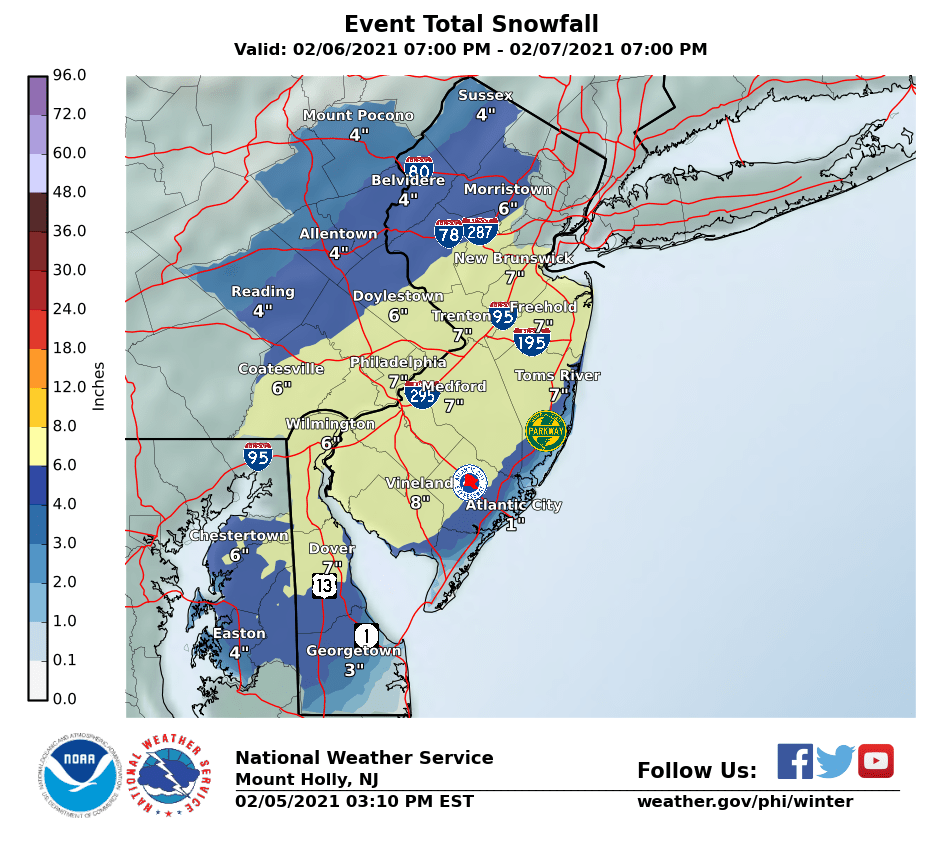
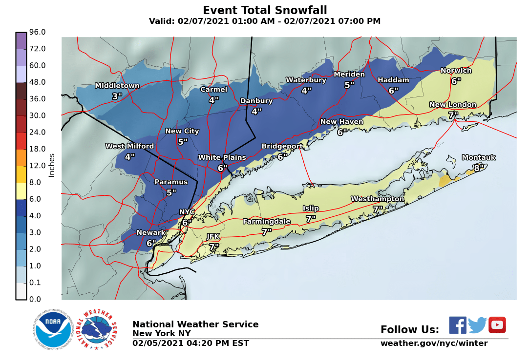
I do like these NWS regional maps for looking at snowfall for the NWS-Philly and NWS-NYC offices, including all of NJ, and even extending further down to DC, out to State College and up to about Hartford.

Current snowfall forecast. This is a fast mover. It will be in Sunday morning and out Sunday night. A general 4-8 inches is likely.
My gut is telling me to not buy into it for 6+ inches that far south. Like usual, expect sharp dropoff of amounts along the NJTP. Shift the heaviest snow band a little north, and it's technically not a bust, but those of us in 609 land making preparations based on a call of 6-8 and then wind up with a slushy 2 inches got busted, but Morris County gets NAM'd so it all balances out.
Well, I mean... if you actually get a choice in how you're assessed, then I'd recommend choosing to be assessed on your observations just after the storm.Great question - depends who you ask. Most forecasters think their forecasts about 12 hours before the start of the event are what they should be assessed on, as that's usually enough time for anyone to plan on (especially if they're not far from their forecasts 24-48 hrs out). For the last storm, that was 11" for Philly from the NWS about 9-12 hrs before the start. Doesn't mean they won't still update their forecasts closer to the start and even after, as people need to know if there are changes. So for this storm, which should be starting in the 4 am-7 am range for Philly, the forecast tomorrow late afternoon/early evening is what I would measure them against.
Also, Philly had 6 measurements between 7.7 and 10.0" (the 6.9" measurement was too early IMO, as it likely missed an inch or so that fell), including 8.1" at the airport, hence my 8-10" comment. The airport is the location of record for Philly - and is often the lowest snowfall in the city, being in the far southern part of the city at its lowest elevation, also. It was actually a bad place to put the location of record - somewhere like Hunting Park would've been far better, as it's centrally located. It's why NYC's Central Park is a pretty good spot for the location of record for NYC.
Funny tidbit. The area at which they measure at Philadelphia Airport isn't in Philadelphia. Hasn't been for years. About 80/90% of the property is in Philadelphia. What was the final measurement for Point Breeze section of Philly? That maybe the closest to City Hall.Great question - depends who you ask. Most forecasters think their forecasts about 12 hours before the start of the event are what they should be assessed on, as that's usually enough time for anyone to plan on (especially if they're not far from their forecasts 24-48 hrs out). For the last storm, that was 11" for Philly from the NWS about 9-12 hrs before the start. Doesn't mean they won't still update their forecasts closer to the start and even after, as people need to know if there are changes. So for this storm, which should be starting in the 4 am-7 am range for Philly, the forecast tomorrow late afternoon/early evening is what I would measure them against.
Also, Philly had 6 measurements between 7.7 and 10.0" (the 6.9" measurement was too early IMO, as it likely missed an inch or so that fell), including 8.1" at the airport, hence my 8-10" comment. The airport is the location of record for Philly - and is often the lowest snowfall in the city, being in the far southern part of the city at its lowest elevation, also. It was actually a bad place to put the location of record - somewhere like Hunting Park would've been far better, as it's centrally located. It's why NYC's Central Park is a pretty good spot for the location of record for NYC.
Good Afternoon Everyone! The next winter storm is expected Saturday night into Sunday. Areas near and along the Interstate 95 corridor are expected to have the highest amounts with a widespread 6 to 8 inches forecast. Locally higher amounts over 8 inches are possible along a narrow corridor, though the location of this is still very uncertain. For the latest briefing package, please visit https://www.weather.gov/media/phi/current_briefing.pdf (you may need to refresh or clear your cache to see the latest briefing)

My gut usually tells me that, too, as it seems like these systems move NW in the last 24-48 hrs more than SE, meaning the coast often gets more rain, but sometimes the worm turns and the track sticks and the coast is toast. Could be this one...My gut is telling me to not buy into it for 6+ inches that far south. Like usual, expect sharp dropoff of amounts along the NJTP. Shift the heaviest snow band a little north, and it's technically not a bust, but those of us in 609 land making preparations based on a call of 6-8 and then wind up with a slushy 2 inches got busted, but Morris County gets NAM'd so it all balances out.
I have always thought that the Delaware Bay and River are not properly accounted for these days making a forecast. With climate change the waters are much warmer through the Winter than when I first moved into this area in 1988. That winter the River frooze over at the Ben Franklin Bridge so bad that the Coast Guard had to send up Ice Breakers. I had a great view from my office just behind Independence Hall. I dont believe it has come close to freezing over in 30 years.My gut usually tells me that, too, as it seems like these systems move NW in the last 24-48 hrs more than SE, meaning the coast often gets more rain, but sometimes the worm turns and the track sticks and the coast is toast. Could be this one...
Yeah, nobody thinks WW is the "best in the business." They're decent and I see their forecasts, too - you actually should watch yourself sharing their forecasts here, as those are for paid subscribers only - pretty sure Frank Lombardo, CEO of WW, who I've known for over 25 years (and is a very good guy), would not be happy to see their private forecasts shared publicly. Wouldn't want another scandal in Montgomery.
Savage.
I'm just gonna leave this here 🎤
Another update!I think 3-6 is a safe call..and the c9ast could get mixing issue
What an overperforming melting day today..almost springlike..50!
Winter Storm Likely Sunday... A coastal system will work its way into the region early Sunday morning bringing snow to central NJ starting just before daybreak. Snowfall intensity is likely to quickly increase following sunrise with periods of moderate to even briefly heavy snow (0.5-1.0"/hr possible) through the first half of the day. Given the origin of this system, snowfall will likely be a touch wetter / denser than normal but winds will not play as much of a factor during this event. Thankfully, we are looking at a fast moving system with a duration of about 10-13 hours before it exits during the mid-afternoon. Given any adjustment in the track we could see a bit of sleet or rain mix in, but for now anticipate all snow... A snow shower may return towards evening as the cold front sweeps through and drops temperatures overnight with just some light recoverings but a higher risk for refreeze.
Start: Sunday - 3:00 AM - 6:00 AM
End: Sunday - 1:00 PM - 4:00 PM
3.0 - 6.0"
0.5 - 1.5"
10%
1.5 - 3.0"
20%
3.0 - 6.0"
50%
6.0 - 10.0"
20%
It's going to have to pack all its own cold air...it is 39 degrees right now in Trenton.My gut usually tells me that, too, as it seems like these systems move NW in the last 24-48 hrs more than SE, meaning the coast often gets more rain, but sometimes the worm turns and the track sticks and the coast is toast. Could be this one...
Did not know that. Sounds similar to EWR not being all in Newark - and the weather station location is actually in Elizabeth in Union County. Here's an interesting tidbit: iirc, you live just into Bucks County from Philly - well Bucks had, by far, the biggest spread of snowfall from low to high of any county in the region, with 7.5" in Bristol vs. 32" in Springtown.Funny tidbit. The area at which they measure at Philadelphia Airport isn't in Philadelphia. Hasn't been for years. About 80/90% of the property is in Philadelphia. What was the final measurement for Point Breeze section of Philly? That maybe the closest to City Hall.
Funny tidbit. The area at which they measure at Philadelphia Airport isn't in Philadelphia. Hasn't been for years. About 80/90% of the property is in Philadelphia. What was the final measurement for Point Breeze section of Philly? That maybe the closest to City Hall.
Did not know that. Sounds similar to EWR not being all in Newark - and the weather station location is actually in Elizabeth in Union County. Here's an interesting tidbit: iirc, you live just into Bucks County from Philly - well Bucks had, by far, the biggest spread of snowfall from low to high of any county in the region, with 7.5" in Bristol vs. 32" in Springtown.
The New Brunswick weather station is in North Brunswick
I moved to Philly over a year ago but did live in Washington Crossing before that. The elevation from Bristol to Springtown is all uphill. And pretty far. PA counties are huge compared to NJ. I think Burlington is the biggest in NJ. Many in PA that dwarf that. But it does go from River to Sea.Did not know that. Sounds similar to EWR not being all in Newark - and the weather station location is actually in Elizabeth in Union County. Here's an interesting tidbit: iirc, you live just into Bucks County from Philly - well Bucks had, by far, the biggest spread of snowfall from low to high of any county in the region, with 7.5" in Bristol vs. 32" in Springtown.
What are the current odds??Putting a dime on no snow in Tampa Bay on SB Sunday,
I do like these NWS regional maps for looking at snowfall for the NWS-Philly and NWS-NYC offices, including all of NJ, and even extending further down to DC, out to State College and up to about Hartford.
Sorry, RU#'s, I had to report you for this post. You mention "State College", and I believe that's a violation of the board rules here. 😀
Actually, Ocean, which is slightly larger than Burlington (always thought Burlington was larger) is larger than Bucks or any of the NWS-Philly counties in PA, but yes Ocean would be about 13th out of 67 PA counties in size.I moved to Philly over a year ago but did live in Washington Crossing before that. The elevation from Bristol to Springtown is all uphill. And pretty far. PA counties are huge compared to NJ. I think Burlington is the biggest in NJ. Many in PA that dwarf that. But it does go from River to Sea.
What does this have to do with snow on Sunday? Nobody is worried about sun angles on Feb 8th.
It gives up hope.
It was an outlier before, although it only looks like a 25% drop, from a general 8-12" to 6-10", which is still a pretty good thump over 8-10 hour; the 0Z (7 pm EST data inputs) 3km NAM really came back down to earth, from 12-18" at 18Z to also 6-10" at 0Z. But it's definitely at least more in line with the general 6-10 snowfall seen at 12Z (7 am EST inputs) for the UK/CMC and a bit more than the 4-7" seen for the Euro/GFS at 18Zfor most of the area - let's see what the rest of the 0Z model suite brings. I still think ~10" (maybe 12" in spots) is the likely ceiling with this event and 4-8" is a pretty good call by the NWS for most.0zNam cut snow totals 40% from its overdone earlier run
Similar threads
- Replies
- 62
- Views
- 3K
- Replies
- 592
- Views
- 16K
OT: Minor to Moderate (2-4?) Snowfall Likely Sat morning (2/17); will be <32F, so expect slick roads
- Replies
- 213
- Views
- 5K
- Replies
- 608
- Views
- 18K
- Replies
- 771
- Views
- 20K
ADVERTISEMENT
ADVERTISEMENT