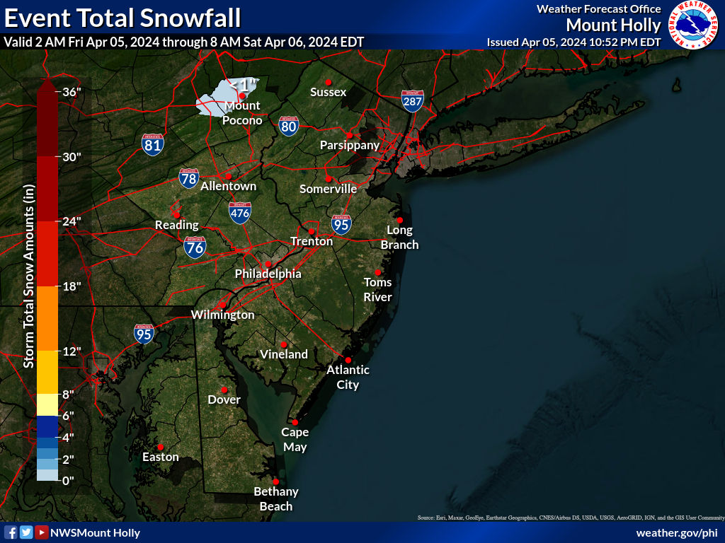
Summary: Little to no snow likely for most, except maybe a minor event for SENJ; could still be a minor event for everyone if the track of the coastal trends back NW and/or if the upper level low overperforms (still 2.5 days out, so some changes are still possible).
Details: So the 6Z models this morning continue with the trend SE with no models currently showing more than 1" for anyone in the Philly-NJ-NYC region, except for the 6Z NAM, which caved SE, but does still show 1-2" for extreme SENJ. However we're still 2.5 days away from the event start (late Weds night) and the players won't all be over land and well-sampled until this afternoon, so there could still be some decent shifts in the model guidance once that occurs, possibly putting our area back into at least minor (1-2") snowfall range, i.e., it's prudent to wait until after tonight's 0Z models to declare the patient completely dead. The NWS/WPC haven't completely thrown in the towel yet, still predicting (through Thursday at 7 am; they also note that a bit more snow could fall through early Thursday afternoon) up to 1" south of 78 and for NENJ/NYC/LI and predicting a minor 1-2" event for Salem to Toms River and SE of that line, but that was before seeing the 6Z models, so they may adjust towards a non-event still.
The NWS is still calling for a minor snowfall south of about 78, as per their 4 am discussion below, but they do note the trends towards a non-event. One other reason to hold off on cancelling this one completely is that Walt Drag, the retired NWS (Boston and Philly) meteorologist, is still calling for 2-6" from NW (Sussex/Poconos) to SE (Jersey coast), despite the models mostly showing nada. He feels the developing strong upper level low dropping down from the Great Lakes through PA/NJ will still produce at least some high ratio powdery snow (from 0.1-0.4" of precip), even if the primary southern coastal low goes too far to our SE to produce snow for anywhere but SENJ and he also thinks snowfall near the NJ coast could be enhanced by an inverted trough from the well offshore low back to the upper level low (which is why he thinks the coast could get the highest amounts).
He recognizes he's largely alone on this, but is sticking with his pattern recognition skills. It's worth noting that he never bought into the major/historic snowfall model runs shown by most of the models 4.5-6 days out (only calling for 2-6" for our area, even if he acknowledged there was potential for more), as he always thought there was a risk that the upper level low and the coastal low wouldn't phase on time for a major coastal storm for our area, which he was right about. It's impressive enough that he never bought in to the big snows, but it would be extraordinarily impressive should we still get minor/moderate snowfall from the ULL (perhaps enhanced by an inverted trough from the coastal low well offshore back to the ULL). A link to his latest post is below.
https://www.americanwx.com/bb/topic...9-12z-fri-221/?do=findComment&comment=7660113
One other comment. In hindsight, it looks like the Euro-AI model has scored a major modeling coup, as it never showed a major snowstorm for our area, unlike every other global model all of which showed at least a few runs with major snowfall. The Euro-AI had most runs in days 4-7 showing a minor to moderate hit (and one run on Sat 12Z with significant snowfall, but not major), which I posted about in the pattern thread before this thread (link to post below). Out of the rest of the models, the GFS was close to the Euro-AI, only showing one major snowfall run, also on 12Z Sat. The Euro, UK and CMC all had multiple major snowfall runs for our region in that timeframe (including some historic runs). Unfortunately, I started this thread after the 12Z Sat runs, which were the snowiest for the entire storm evolution, lol. Bad timing.
https://rutgers.forums.rivals.com/t...ikely-for-most-of-january.287192/post-7137388
https://www.weather.gov/phi
Area Forecast Discussion
National Weather Service Mount Holly NJ
646 AM EST Mon Feb 17 2025
SHORT TERM /TUESDAY NIGHT THROUGH WEDNESDAY NIGHT/...
By Wednesday afternoon high pressure will start to depart as an
upper level low develops south of the Great Lakes. This will result
in an increase in cloud cover over the region ahead of a low
pressure system that starts to initiate well to our south.
Trends in the EC ensemble Low tracks and GEFS low tracks continue to
show the most likely scenario with the low is that is develops well
to the south and doesn`t strengthen until the low is well offshore.
The 00z EC substantially jumped south but the EC ensemble system was
fairly consistent with a slight southern shift relative the to 18z
suite. Given that consistency in a more southern track, the forecast
has been shifted further south with the snow totals highest
over southern Delaware. Based on the 17/00z suite of guidance,
snow is still forecast to move over portions of central and
southern Jersey however if the 00z EC pans out, we may see a
mostly dry event.
NWS snowfall forecast thru 7 am Thursday (note that they're predicting some more light snow thru 1 pm Thursday)


