12Z models (7 am EST data inputs) are almost all in and we have the kind of model mayhem which illustrates the high degree of uncertainty with this storm. I'm still skeptical of more than a slushy inch or so for the 95 corridor before the changeover, with ocean temps in the 50s, but stranger things have happened...
- The new GFS (FV3) and the NAM hammer I-95 with 6" or more of front-end snow before the changeover to rain late Thursday and paste the interior with 10" or more (with a fair amount of these "snow" amounts possibly being sleet) and even have a couple of inches towards the coast (very steep gradient in every model).
- The old GFS and CMC show maybe 1-3" for the 95 corridor, then lots of rain, with 3-6" for interior locations (generally N/W of the 78/287 intersection and especially NW of 80/287 intersection).
- Haven't seen the UK and the Euro just came out and shows 0.4-0.8", still, of frozen precip up through early Thursday evening for the 95 corridor, before the changeover to heavy rain, with 1.2-2.0" of total precip falling (so over 1" of rain on top of any snow/sleet). Euro has had this solution for several runs now and we're only 48-60 hours from the event, so it's possible it'll be right. Euro showing a fair amount more inland, as expected. Pretty sure the NWS will want to see more model consensus, say, 24 hours from now, before taking a snow threat more seriously for the 95 corridor. However, I could see winter storm watches going up for interior sections if tonight's model runs continue to show potential snow/sleet - and maybe advisories tomorrow afternoon for the 95 corridor if a few inches or more look likely by then.
So, given that the models are still showing modest to major snow/sleet accumulations for much of the area (and continue to do so with the latest 18Z models), the NWS offices and most of the local media are now starting to take this threat more seriously, although none of them is predicting the amount of snow/sleet that some models are (6" or more for the 95 corridor in some) and for good reason - ocean water temps are still in the mid-50s, so it's highly likely that the very snowy models are overdone and the easterly winds off the ocean will limit accumulations from the coast to 95 and even inland somewhat.
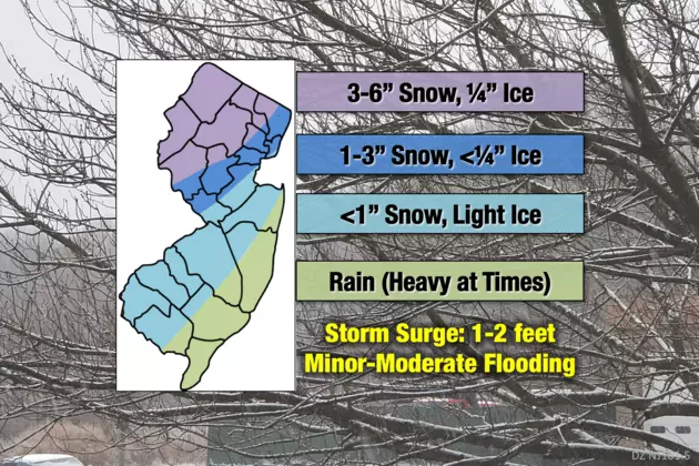
NWS offices in Philly and NYC are now calling for some minor accumulations (1-3") for the Philly-NYC corridor on the front end of the storm in the early/mid-afternoon on Thursday, possibly followed by some sleet and changing over to rain by evening, with heavy rain through Friday morning (1" or more of rain). With temps in the low 30s in the afternoon, snow will accumulate after about 3-4 pm, given the low sun angle and decent rates, so the afternoon rush (in the dark, too) could be a mess.
NWS is calling for more substantial snow/sleet for the interior sections well N/W of 95 and especially N of 78 (and W of 287), with more like 3-5" with the potential for a bit more, especially for areas like the Poconos, Sussex/Warren, NW Morris/Passaic and the Hudson Valley N of the Tappan Zee (and the Catskills and interior New England where 6-8" of more is likely). Could also be up to 1/10th of an inch of freezing rain on top of the snow/sleet.
As always, when we're ~48 hours out, much can change with minor changes in the track and intensity of the surface low coming up the coast, as well as the influence of the upper level low that will be in the TN Valley that will be feeding energy into the coastal low, and, of course, the strength of the cold high pressure that will be in northern New England/Quebec.
Uncertainty is high enough that for NB, for example, we could see all rain, 1-3" of snow/sleet, then a lot of rain, 3-5" of snow/sleet then a fair amount of rain or even 5-8" of snow/sleet, then some rain. Difficult forecast. NWS-NYC map is below; haven't seen one from NWS-Philly yet, but you can easily imagine that 2" line running roughly from NYC to Newark to NB to Trenton to Philly. NWS discussion is below.
National Weather Service Mount Holly NJ
310 PM EST Tue Nov 13 2018
LONG TERM /WEDNESDAY NIGHT THROUGH TUESDAY/...
Active weather in the long term focuses on the nor`easter which
is likely to affect the region Thursday into Friday. This system
will have plenty of Gulf and Atlantic moisture to work with and
strong dynamics thanks to a potent upper level disturbance,
combined with strong baroclinic forcing due to the unusually
cold air mass meeting the still warm Atlantic waters. After the
system passes Friday, high pressure will likely result in much
quieter weather this weekend into early next week.
At the start of the period on Wednesday night, high pressure
shifts to the northeast of the region into southern Canada while
low pressure develops to the southwest. After a mostly clear
start, high clouds should move in, then thicken and lower as the
night progresses. Lows will mostly be below freezing, though
warmer areas near the coast and in southern NJ/DE may stay in
the mid 30s.
Warm advection precip overspreads the region ahead of the main
low pressure as we head through Thursday. Have not made
significant adjustments to the forecast given its still a couple
days out, but it is notable that the onset looks earlier, and
overall models seem to have trended a bit colder. Snow is
possible along and even southeast of the I-95 corridor at the
onset, with accumulations more likely northwest of I-95. As warm
advection brings a warm nose aloft, snow likely changes to
sleet/freezing rain where the low level cold can hold firm, and
this could also last for some time especially NW of I-95. Winter
Storm Watches could be required for at least northwestern
portions of the CWA. Near I-95, the issue is always just how
quickly the warmer maritime air can nudge out the cold Canadian
air, which is often a struggle. The details have yet to be
fleshed out, but the bottom line is that there could be
significant issues with wintry weather all the way down to I-95
through much of the day Thursday, perhaps even into Thursday
night.
As the surface low heads northeast of the region later
Thursday night into early Friday, a changeover back to snow from
ice/rain is possible, though this is highly uncertain.
Regardless, as the low strengthens, some gusty winds are likely
especially Thursday night and Friday as the low pulls away. For
those locations which receive freezing rain (glaze ice), this
could be a significant issue.
https://www.weather.gov/phi/
https://forecast.weather.gov/produc...&format=CI&version=1&glossary=1&highlight=off

Last edited: