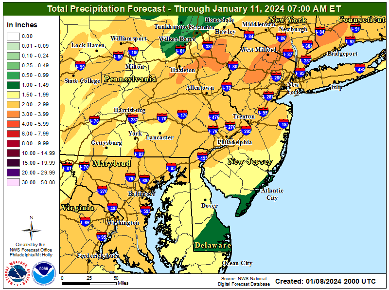
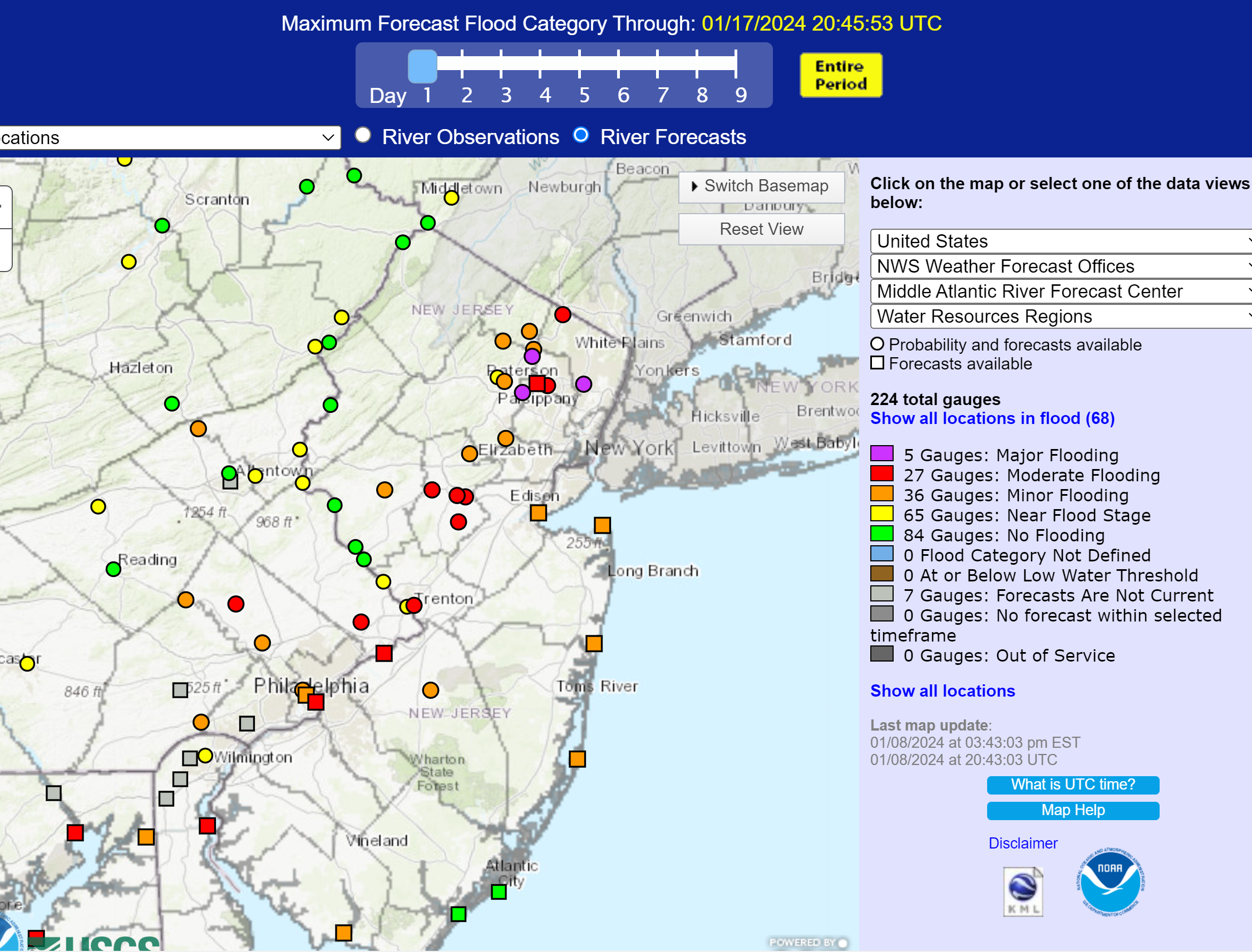
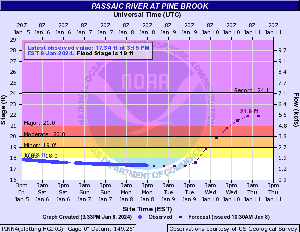
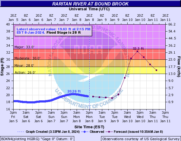
Curious. If the data is available, why couldn't (and really shouldn't being the better word) an app access it/exhibit it etc? Just a general question.Some serious rainfall expected, with the heaviest rains forecast to be right over the Passaic and Raritan River basins. The 2nd graphic shows the overview of predicted max flooding levels for all of the major river basins in our region, with the purple ones indicating major flood stage being reached and the red ones indicating moderate flood stage being reached. One can then click on the dot and get the full flooding forecast for this storm for any individual river gauge - I included the Passaic at Pine Brook (showing major flooding) and the Raritan at Bound Brook (showing almost major flooding), below, as examples.
This is exactly the kind of important rainfall/flooding data one can get from a friggin app. Not.
https://www.weather.gov/marfc/


Colleges
- American Athletic
- Atlantic Coast
- Big 12
- Big East
- Big Ten
- Colonial
- Conference USA
- Independents (FBS)
- Junior College
- Mountain West
- Northeast
- Pac-12
- Patriot League
- Pioneer League
- Southeastern
- Sun Belt
- Army
- Charlotte
- East Carolina
- Florida Atlantic
- Memphis
- Navy
- North Texas
- Rice
- South Florida
- Temple
- Tulane
- Tulsa
- UAB
- UTSA
- Boston College
- California
- Clemson
- Duke
- Florida State
- Georgia Tech
- Louisville
- Miami (FL)
- North Carolina
- North Carolina State
- Pittsburgh
- Southern Methodist
- Stanford
- Syracuse
- Virginia
- Virginia Tech
- Wake Forest
- Arizona
- Arizona State
- Baylor
- Brigham Young
- Cincinnati
- Colorado
- Houston
- Iowa State
- Kansas
- Kansas State
- Oklahoma State
- TCU
- Texas Tech
- UCF
- Utah
- West Virginia
- Illinois
- Indiana
- Iowa
- Maryland
- Michigan
- Michigan State
- Minnesota
- Nebraska
- Northwestern
- Ohio State
- Oregon
- Penn State
- Purdue
- Rutgers
- UCLA
- USC
- Washington
- Wisconsin
High Schools
- Illinois HS Sports
- Indiana HS Sports
- Iowa HS Sports
- Kansas HS Sports
- Michigan HS Sports
- Minnesota HS Sports
- Missouri HS Sports
- Nebraska HS Sports
- Oklahoma HS Sports
- Texas HS Hoops
- Texas HS Sports
- Wisconsin HS Sports
- Cincinnati HS Sports
- Delaware
- Maryland HS Sports
- New Jersey HS Hoops
- New Jersey HS Sports
- NYC HS Hoops
- Ohio HS Sports
- Pennsylvania HS Sports
- Virginia HS Sports
- West Virginia HS Sports
ADVERTISEMENT
You are using an out of date browser. It may not display this or other websites correctly.
You should upgrade or use an alternative browser.
You should upgrade or use an alternative browser.
OT: Round 2 Rainstorm 1/12 (not as bad as round 1); Rainstorm 1/9-10 - Major Urban/Stream Flooding, High Winds and Coastal Flooding Likely
- Thread starter RU848789
- Start date
- Status
- Not open for further replies.
Enough with the nonsense people. I just want the damn weather and I don't care about the different sources as it's good to have multiple.
What the hell is going on in this thread? Everyone is trying to troll each other. People need to grow up and be more professional.
Thanks!
:)
Thanks!
:)
For folks in the Monty/Hills/Prince/etc. area. The Millstone River is still crazy high. The Griggstown Causeway was already very close to flood level (drove by on the way home from work). LOL. If we get a lot of rain, there gonna be problems.
I’m coming up from Philly for the game. Is the NJ turnpike and I-95 going to be a shit show on the way home?
That area is always trouble. Would not be surprised to see those causeways closed in the next couple of days.For folks in the Monty/Hills/Prince/etc. area. The Millstone River is still crazy high. The Griggstown Causeway was already very close to flood level (drove by on the way home from work). LOL. If we get a lot of rain, there gonna be problems.
Murphy has declared a state of emergency effective 5pm tomorrow - just got a call from Hillsborough schools that all after school activities are cancelled. He's not restricting travel, but that will also dampen attendance for tomorrow night.
Q
Agree..lets get on bacontrack
Enough with the nonsense people. I just want the damn weather and I don't care about the different sources as it's good to have multiple.
Agree..lets get on bacontrack
Seriously, you can go spit in the Millstone near the Griggs causeway and it will flood. It's that super saturated. My area is used to the Griggs and Blackwell Mills causeways closing, but a significant amount of rain will also overflow River Road in Belle Mead and the River Road at the Monty/Princeton border.That area is always trouble. Would not be surprised to see those causeways closed in the next couple of days.
You can almost count on closures in those areas after tomorrow’s rain.Seriously, you can go spit in the Millstone near the Griggs causeway and it will flood. It's that super saturated. My area is used to the Griggs and Blackwell Mills causeways closing, but a significant amount of rain will also overflow River Road in Belle Mead and the River Road at the Monty/Princeton border.
It's really amusing reading the last hour or two of this thread - those of you going after others who you think troll the weather threads have basically succeeded in hijacking the thread. Think about that for a moment.
Not true at all. Some of us have been trying to get the thread back on track. And you use the term troll a little too loosely for being a mod. What have you done to clean up these threads?It's really amusing reading the last hour or two of this thread - those of you going after others who you think troll the weather threads have basically succeeded in hijacking the thread. Think about that for a moment.
And another ironic thing is that as the thread was getting back on track, you brought it back to troll/argue mode. Whatever. Let’s move on.It's really amusing reading the last hour or two of this thread - those of you going after others who you think troll the weather threads have basically succeeded in hijacking the thread. Think about that for a moment.
Just getting ready for Numbers' next post:And another ironic thing is that as the thread was getting back on track, you brought it back to troll/argue mode. Whatever. Let’s move on.

And their founder & chief executive is a Penn State graduate.From probably the most predatory, slimy source out there, lol. They're well known for trying to generate clicks, especially as they're the ones who started putting out 45 and then even 90 day forecasts, which are 100% useless. They also wanted to privatize the NWS and have private companies charging for weather data and forecasts. I'm sure their short-term forecasts are fine, but why give clicks to a company like that?
https://www.sciencealert.com/how-many-days-can-you-trust-the-weather-forecast-for
Spanks is right...its a serious event. I suggest some zero tolerance moderation from here on
Spanks is right...its a serious event. I suggest some zero tolerance moderation from here on
Now I need to really laugh at you! C’mon man! 😂Spanks is right...its a serious event. I suggest some zero tolerance moderation from here on
During Ida's flooding, the Turnpike was my only realistic route to work. All the little unnamed tributaries flooded 130, 1, and all the county roads between Hamilton and Cranbury.I’m coming up from Philly for the game. Is the NJ turnpike and I-95 going to be a shit show on the way home?
I really don't know how bad it's going to be tomorrow night, but Wednesday is going to be ugly. I full expect both of my first choice routes home from work to be flooded:
Hamburg Turnpike:

Route 23:

Hamburg Turnpike:

Route 23:

In the past, you guys used to moderate these threads and they were much better, at least IMO. There were a whole bunch of true trolling attempts to derail the thread on page 1, but nobody took the bait. The stuff the past few hours was more just bickering, which is par for the course for the board for most threads, although it's a bit mind boggling that we can't have unanimity that 45+ day forecasts are shite. However, it's a fair point that I probably should have left the company-bashing out of my post and focused on just bashing the ludicrous 45+ day forecasts (and really, anything beyond about 10 days). Back to the football game...It's really amusing reading the last hour or two of this thread - those of you going after others who you think troll the weather threads have basically succeeded in hijacking the thread. Think about that for a moment.
https://www.washingtonpost.com/news...r-you-cannot-be-serious-new-45-day-forecasts/
So, no rain this week now? :)
nope i am being serious...there were Numbers stans that totally derailed the last page..move onNow I need to really laugh at you! C’mon man! 😂
i would not post wa post..just sayingIn the past, you guys used to moderate these threads and they were much better, at least IMO. There were a whole bunch of true trolling attempts to derail the thread on page 1, but nobody took the bait. The stuff the past few hours was more just bickering, which is par for the course for the board for most threads, although it's a bit mind boggling that we can't have unanimity that 45+ day forecasts are shite. However, it's a fair point that I probably should have left the company-bashing out of my post and focused on just bashing the ludicrous 45+ day forecasts (and really, anything beyond about 10 days). Back to the football game...
https://www.washingtonpost.com/news...r-you-cannot-be-serious-new-45-day-forecasts/
lets get bac to discussing this event
Yep, a lot of folks don't realize that the larger rivers take a lot longer to reach the various flood stages, whereas smaller creeks and streams will usually reach their max flood stage within a few hours of precip ending.I really don't know how bad it's going to be tomorrow night, but Wednesday is going to be ugly. I full expect both of my first choice routes home from work to be flooded:
Hamburg Turnpike:

Route 23:

If there is anyone out there who thinks they might have to negotiate a potentially flooded stream or river, the flood stage maps are indispensable and easy to access/read from the link below. In addition to being able to click on the dot for a specific river location/gauge to get the hydrographs Spanky and I have shared (showing flood stages), one can also click on the "inundation mapping" button to get the map below which shows, for a given flood stage (this is 32.1', which is about what the Raritan at Bound Brook is forecast to reach on Weds), the depth of inundation in the area and one can click on a flooded area to get the expected depth.
https://www.weather.gov/marfc/

We are building the Ark in our back yard.So, no rain this week now? :)
You get flooding in your part of MontyVille?
If you're going to say that, why even bother trying to discuss meteorology? The guys at the Capital gang are some of the best pro mets in the business. You would be banned for making a post like this on a weather board.i would not post wa post..just saying
lets get bac to discussing this event
The governor is a jackass for the state of emergency already. My son’s office told him not to come in tomorrow. He generally only goes in until lunchtime anyway due to their hybrid schedule. The rain is not even supposed to start until 1-2 PM up here. Screws up the rest of his week because Wednesday will be the sh*t show.
In my neighborhood, no. Never been a problem. The adjacent neighborhood (lower land) gets totally f'ed up due to ground water rising into basements. Their water table is very high. No surface flooding, which in some ways is easier to deal with.We are building the Ark in our back yard.
You get flooding in your part of MontyVille?
During flooding events, I always think about Manville and the Lost Valley. I was on the local flood control commission for 5-6 years and tons of Manville residents would attend. Their stories were always heartbreaking. And all due to the MF'ing overdevelopment in CNJ, much of it pushed by the state.
This could save people’s lives, your son isn’t the center of the universe. Flooding happens everywhere now.The governor is a jackass for the state of emergency already. My son’s office told him not to come in tomorrow. He generally only goes in until lunchtime anyway due to their hybrid schedule. The rain is not even supposed to start until 1-2 PM up here. Screws up the rest of his week because Wednesday will be the sh*t show.
Well that's kind of on your son's office. They could've just closed early. Remember, a SOE typically is a way for the State to put resources in place in advance of expected emergencies and it does not mean people can’t drive or that events are cancelled. See the excerpt from the linked article. RU may still decide to postpone events like the game or close the U, but that would be almost unprecedented for a rain event that's not tropical storm related. Yes, flooding is likely to be bad (but much moreso early Weds than Tues evening unless the rain overperforms) but I see no reason to postpone this far in advance.The governor is a jackass for the state of emergency already. My son’s office told him not to come in tomorrow. He generally only goes in until lunchtime anyway due to their hybrid schedule. The rain is not even supposed to start until 1-2 PM up here. Screws up the rest of his week because Wednesday will be the sh*t show.
https://www.nj.com/weather/2024/01/...ergency-ahead-of-dangerous-january-storm.html
“States of emergencies do not ban people from the roads or require them to shelter in place. Instead, they allow the state to organize its emergency response and to become eligible for federal disaster aid.”
If you're going to say that, why even bother trying to discuss meteorology? The guys at the Capital gang are some of the best pro mets in the business. You would be banned for making a post like this on a weather board.
A weather board silencing free speech is so 2020
It's not a free speech issue as boards are privately run typically. It's a stupidity issue, as they also would ban people who think "chemtrails" are impacting our weather.A weather board silencing free speech is so 2020
We did not close the office, but did a somewhat "soft close," letting people know that they could work from home, which they could do anyway. For us, living close to the coast, and me being on the fire department, we expect a busy day tomorrow, likely mostly babysitting downed wires and trees on wires until the utility company comes. The wind gusts will start picking up in the early after.Well that's kind of on your son's office. They could've just closed early. Remember, a SOE typically is a way for the State to put resources in place in advance of expected emergencies and it does not mean people can’t drive or that events are cancelled. See the excerpt from the linked article. RU may still decide to postpone events like the game or close the U, but that would be almost unprecedented for a rain event that's not tropical storm related. Yes, flooding is likely to be bad (but much moreso early Weds than Tues evening unless the rain overperforms) but I see no reason to postpone this far in advance.
https://www.nj.com/weather/2024/01/...ergency-ahead-of-dangerous-january-storm.html
“States of emergencies do not ban people from the roads or require them to shelter in place. Instead, they allow the state to organize its emergency response and to become eligible for federal disaster aid.”
It's not a free speech issue as boards are privately run typically. It's a stupidity issue, as they also would ban people who think "chemtrails" are impacting our weather.
Wonder if they would ban lab leak theory
Spanks is right...its a serious event. I suggest some zero tolerance moderation from here on
A weather board silencing free speech is so 2020
Wonder if they would ban lab leak theory
Wow, bringing up hot button issues like free speech and COVID in the two posts after your suggestion of zero tolerance. Wonder if the mods will take you up on that.
- Status
- Not open for further replies.
Similar threads
- Replies
- 87
- Views
- 4K
- Replies
- 223
- Views
- 9K
- Replies
- 135
- Views
- 6K
ADVERTISEMENT
ADVERTISEMENT