ADVERTISEMENT

OT: Round 2 Rainstorm 1/12 (not as bad as round 1); Rainstorm 1/9-10 - Major Urban/Stream Flooding, High Winds and Coastal Flooding Likely

Status
Not open for further replies.
Dann Zarrow

attachment-Rain-and-Wind-Machine-20240109.jpg


heaviest rain 6-2 am and wind really picking up this evening.

its tomorrow when the rivers cresting that will likely be when the worst of the flooding occurs but there will be street and highway flooding during the height of the storm
 
Dann Zarrow

attachment-Rain-and-Wind-Machine-20240109.jpg


heaviest rain 6-2 am and wind really picking up this evening.

its tomorrow when the rivers cresting that will likely be when the worst of the flooding occurs but there will be street and highway flooding during the height of the storm
You going to the game tonight?
 
URGENT - WEATHER MESSAGE
National Weather Service Mount Holly NJ
316 AM EST Tue Jan 9 2024

DEZ001-002-MDZ012-015-019-020-NJZ001-007>010-012-015>019-PAZ054-
055-060>062-070-071-101>106-092200-
/O.CON.KPHI.WI.Y.0001.240109T2200Z-240110T0800Z/
New Castle-Kent-Kent MD-Queen Annes-Talbot-Caroline-Sussex-Warren-
Morris-Hunterdon-Somerset-Middlesex-Mercer-Salem-Gloucester-
Camden-Northwestern Burlington-Carbon-Monroe-Berks-Lehigh-
Northampton-Delaware-Philadelphia-Western Chester-Eastern Chester-
Western Montgomery-Eastern Montgomery-Upper Bucks-Lower Bucks-
Including the cities of Wilmington, Dover, Chestertown,
Centreville, Easton, Denton, Newton, Washington, Morristown,
Flemington, Somerville, New Brunswick, Trenton, Pennsville,
Glassboro, Camden, Cherry Hill, Moorestown, Mount Holly,
Jim Thorpe, Stroudsburg, Reading, Allentown, Bethlehem, Media,
Philadelphia, Honey Brook, Oxford, West Chester, Kennett Square,
Collegeville, Pottstown, Norristown, Lansdale, Chalfont,
Perkasie, Morrisville, and Doylestown
316 AM EST Tue Jan 9 2024

...WIND ADVISORY REMAINS IN EFFECT FROM 5 PM THIS AFTERNOON TO
3 AM EST WEDNESDAY...

* WHAT...Southeast winds 25 to 35 mph with gusts up to 55 mph
expected.

* WHERE...Portions of central and northern Delaware, northeast
Maryland, central, northern, northwest and southern New Jersey
and east central, northeast and southeast Pennsylvania.

* WHEN...From 5 PM this afternoon to 3 AM EST Wednesday.

* IMPACTS...Gusty winds could blow around unsecured objects.
Tree limbs could be blown down and a few power outages may
result.

* ADDITIONAL DETAILS...Southeast winds will increase during today
and become stronger later this afternoon. The strongest winds
are expected to occur this evening, and these could be locally
enhanced with a narrow line of intense showers tonight. In
addition, saturated ground after multiple rounds of heavy
rainfall over the last month results in trees being more
vulnerable to strong winds.

PRECAUTIONARY/PREPAREDNESS ACTIONS...

Use extra caution when driving, especially if operating a high
profile vehicle. Secure outdoor objects.

Flood Watch
National Weather Service Mount Holly NJ
304 AM EST Tue Jan 9 2024

NJZ001-007>010-PAZ054-055-060>062-101>105-092215-
/O.CON.KPHI.FA.A.0001.240109T1800Z-240110T2300Z/
/00000.0.ER.000000T0000Z.000000T0000Z.000000T0000Z.OO/
Sussex-Warren-Morris-Hunterdon-Somerset-Carbon-Monroe-Berks-
Lehigh-Northampton-Western Chester-Eastern Chester-Western
Montgomery-Eastern Montgomery-Upper Bucks-
Including the cities of Perkasie, Flemington, Norristown,
Allentown, Jim Thorpe, Newton, Reading, Stroudsburg, Honey Brook,
Pottstown, Morristown, Somerville, Chalfont, Kennett Square,
Collegeville, Washington, West Chester, Easton, Lansdale, Oxford,
and Bethlehem
304 AM EST Tue Jan 9 2024

...FLOOD WATCH REMAINS IN EFFECT FROM 1 PM EST THIS AFTERNOON
THROUGH WEDNESDAY AFTERNOON...

* WHAT...Flooding caused by excessive rainfall continues to be
possible.

* WHERE...Portions of New Jersey, including the following areas,
Hunterdon, Morris, Somerset, Sussex and Warren and Pennsylvania,
including the following areas, Berks, Carbon, Eastern Chester,
Eastern Montgomery, Lehigh, Monroe, Northampton, Upper Bucks,
Western Chester and Western Montgomery.

* WHEN...From 1 PM EST this afternoon through Wednesday afternoon.

* IMPACTS...Excessive runoff may result in flooding of rivers,
creeks, streams, and other low-lying and flood-prone locations.
Area creeks and streams are running high and could flood with more
heavy rain.

* ADDITIONAL DETAILS...
- Rainfall of 2 to 3 inches with locally up to 4 inches
possible later today and tonight, with the heaviest rain
occurring later this afternoon and this evening. The ground
remains very saturated following multiple rounds of heavy
rainfall over the last month. A period of higher hourly
rainfall rates is possible tonight which would enhance the
potential for flooding, particularly in the more urban areas.
The combination of snow melt and heavy rain may significantly
elevate the flooding risk, especially across northeast
Pennsylvania and northern New Jersey.
- http://www.weather.gov/safety/flood

PRECAUTIONARY/PREPAREDNESS ACTIONS...

You should monitor later forecasts and be alert for possible Flood
Warnings. Those living in areas prone to flooding should be prepared
to take action should flooding develop.

&&
 
  • Like
Reactions: Knight Shift
My office just announced a 3pm closing (doesn't matter to me, working from home today). Also, no after school activities for the little one.

School activities cancelled in Union/Morris county area as well.

I'm in the city so doubtful office is closing but I'm heading out around 3 to avoid any potential NJT issues.
 
  • Like
Reactions: T2Kplus20
game time decision
The issue is Hillsborough is an island. When the Raritan is flooded over you can't get through the western part, 206 floods at Somerville /Raritan. Flooding occurs by the Montgomery/ Hillsborough border. Millstone Bridge by Amwell Rd always floods. Sometimes the only way is going thru Manville via Finderne and getting off Camplain Rd.
 
People dumping their tickets left and right for tonight. Get in price now $7.
 
I can feel (inside the house) and hear the wind getting stronger.
 
It's a steady rain here now, no real wind as of yet.
 
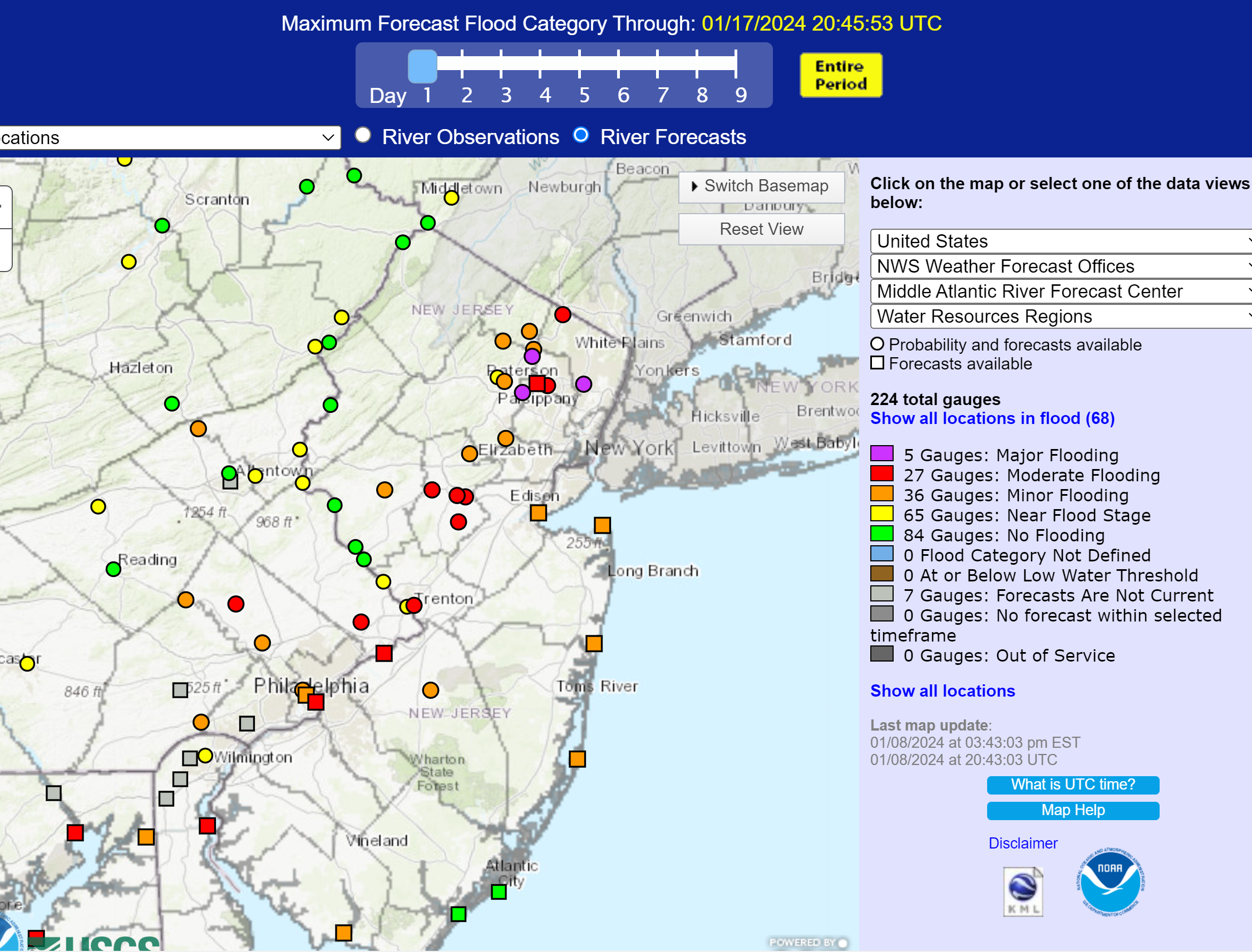
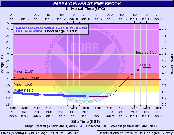
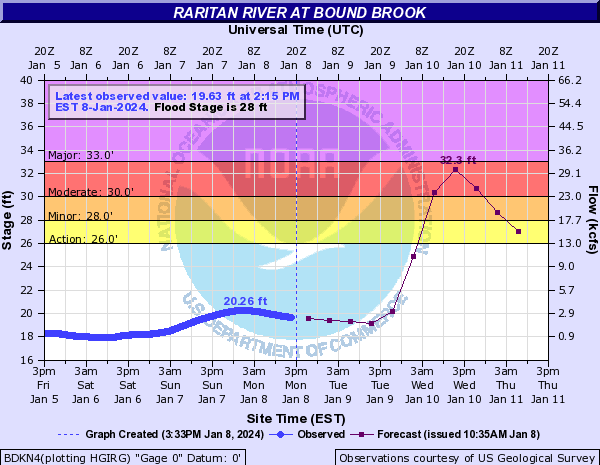
Some serious rainfall expected, with the heaviest rains forecast to be right over the Passaic and Raritan River basins. The 2nd graphic shows the overview of predicted max flooding levels for all of the major river basins in our region, with the purple ones indicating major flood stage being reached and the red ones indicating moderate flood stage being reached. One can then click on the dot and get the full flooding forecast for this storm for any individual river gauge - I included the Passaic at Pine Brook (showing major flooding) and the Raritan at Bound Brook (showing almost major flooding), below, as examples.

This is exactly the kind of important rainfall/flooding data one can get from a friggin app. Not.

https://www.weather.gov/marfc/

QKmO3B1.png


I8icVov.png


TjeWQVM.png


zlibrWV.png
Summary: Back to the weather, not a lot has changed since this post and these graphics, really, summarize all they key risks from 2-3" (or more) of heavy rain leading to urban/river flooding, high winds and power outages, and coastal and tidal flooding risks along tidal rivers like the Delaware and Hudson. The NWS briefing link, below is chock full of good graphics, some of which are reproduced in this post. There's also the general NWS-Philly office link and a link to the AmericanWx thread on the storm. Beyond our area, there is severe weather in the SE (with damaging tornadoes already in FL), as well as heavy rains, plus on the cold side there is heavy snow and blizzard conditions in parts of the Midwest/Great Lakes, plus winter storm warnings in Maine and parts of northern New England for 6-12" of snow before a changeover to rain (even for the ski resorts).

https://www.weather.gov/media/phi/current_briefing.pdf
https://www.weather.gov/phi/
https://www.americanwx.com/bb/topic...ses-jan-10-and-beyond-damaging-wind/page/104/

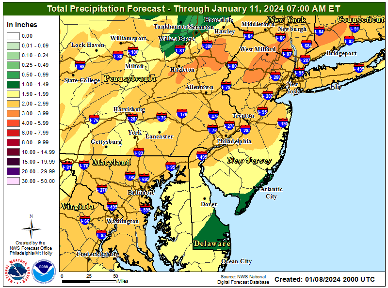
Details: Again, there is 2-3" of rain likely for the region leading to significant to major stream/river flooding for much of CNJ/NNJ, especially for the Raritan and Passaic River basins (including the Saddle River and Pompton River) and moderate flooding for most other rivers/streams in the region. If 4" or more fall (low probability, but possible), flooding would be more severe; note that max flooding will likely be well after 1-2 am for the major rivers and possibly not until Weds afternoon/evening. There will also be significant urban/poor drainage flooding, so many roads are going to be flooded simply from the rainfall (in addition to streams/rivers).

The first graphic below shows forecast rainfall for the region, while the 2nd graphic is the NWS flooding risk summary and the 3rd graphic is the River Forecast Center's forecast for max river flooding for the region (and the link allows one to click on any river/gauge for detailed flooding forecasts); I also included the forecast max flood risk for the Passaic River at Pine Brook and the Raritan at Bound Brook, as examples.

https://www.weather.gov/marfc/

A high wind warning is up for all coastal areas from DE to NJ to NY/LI for 60-70 mph gusts and a wind advisory is up for everywhere else inland wit 50-55 mph gusts likely. These winds will likely lead to some downed trees/power lines leading to power outages and other damage and will also likely lead to significant flight delays and cancellations. There is also a graphic summarizing max wind gusts for the region.

In addition, there are coastal flood warnings up for the tidal Delaware River up past Trenton and for Delaware and Chesapeake Bays and a flood advisory for the tidal Hudson River for NENJ/NYC up to the Tappan Zee, as well as a coastal flood advisory for Atlantic/Cape May counties and a coastal flood warning for Ocean County and coastal Long Island/CT; note that Monmouth County has no coastal flood advisory (due to orientation of the coast relative to southerly winds). The last graphic summarized all of these as it's kind of complex.

Lastly, we're likely to get another 1-1.5" or rain on Saturday and most models are showing some sort of winter storm next Tuesday, with some showing significant snowfall for the region. Way too far out for any forecasts on that one, but we do know it's supposed to get cold after Saturday's rainfall with below normal temps expected from then through all of next week, at least.

0YZnONw.png


ADweZys.png


egjmnNv.png


sRxr5YS.png


aKj9hfN.png


8kLQLpG.png


OQuC3EQ.jpg
 
Last edited:
Very light sprinkling of rain in FiDi of NYC.
Windy as well but it's always a wind tunnel down here.
 
Mets or not they do seem able to predict the weather. And isn't that the point? (I know it isn't)
You need to improve your reading comprehension. AccuWeather is fine for short term (up to 7-8 days) forecasting, but their 25, 45, and 90 day forecasts are 100% useless with little accuracy greater than what simple climatology would predict for temps and terrible accuracy for precip, as nobody on the planet is capable of predicting accurately what's going to happen on a specific day, beyond 7-8 days. Read up a little on chaos theory and its application to numerical modeling (i.e., the "butterfly effect") if you want to know why.
 
You need to improve your reading comprehension. AccuWeather is fine for short term (up to 7-8 days) forecasting, but their 25, 45, and 90 day forecasts are 100% useless with little accuracy greater than what simple climatology would predict for temps and terrible accuracy for precip, as nobody on the planet is capable of predicting accurately what's going to happen on a specific day, beyond 7-8 days. Read up a little on chaos theory and its application to numerical modeling (i.e., the "butterfly effect") if you want to know why.
perhaps why you should temper when you go into your COLD PERIOD COMING in 3 weeks type threads
 
Status
Not open for further replies.
ADVERTISEMENT
ADVERTISEMENT