ADVERTISEMENT

OT: Major winter storm 3/20-21?

Last night a tree fell on the power line and caught fire down the street from someone I know so he's been without power since. He lives right off the eastern end of Mantoloking Rd.

That's awful. Middle School baseball started on Monday. I guess we're done for a week or so.
 
Cranky was explaining why places were not getting the high amounts like 15-22...certainly verified for some of us like me and other parts of western jersey...he in later tweets explained how the movement of the storm got delayed which put an additional 4-5 inches at the coast so he definitely acknowledged this..he gave in storm analysis which was good to see because most weenies stop analyzing. I didnt see his tweets after 8 so ill have to go back

And its not a contest on who is right so not sure why you are claiming some sort of victory

Partly, but he was also saying that part 2 was going to underperform, escaping to the east, whereas what I posted here was from mets like HM, earthlight, and isotherm (not a met but should be), saying that the 750 mbar low would swing from Philly to off of AC, energizing the surface low into pouring those moisture laden bands into NJ/NY and producing huge snows from 5 pm onward for most.

I picked the right guys and you picked the wrong guy, probably because his scenario was little snow and you hate snow. I picked the guys with the better track record, who sniffed this pattern out in February and stuck to their guns that it was going to potentially produce cold and huge snows in March. So yeah, I'd say I can claim victory on touting what they were saying, here, as well as never wavering on the potential of yesterday's storm, even when it would've been easy to dismiss it.
 
29060648_1883499478350108_2716613780752726724_o.png


28700726_1737591946284384_4714088976961566544_o.jpg
 
I'm so happy I didn't waste anytime trying to dig out or blow out the driveway today. Driveway totally clear after a 50 degree day in Hopewell.
 
  • Like
Reactions: T2Kplus20
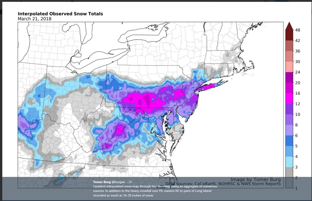
NWS reduced snowfall to where I thought they would, i..e., to about 10-14" for most of the 95 corridor and areas within 30-40 miles of there, while they reduced far NWNJ and the Poconos/Lehigh Valley to 6-10", due to less precip and the coast to 6-10", due to mixing (and to only a few inches along extreme SNJ. Still waiting for the NWS NYC map.

29426038_10213510590033170_9037123198130323456_n.jpg

29468201_10213510590073171_1607569996483919872_o.jpg


Well, no map yet, but surprisingly, NWS NYC still says 12-18" still for most of their area, as per below...

National Weather Service New York NY
446 AM EDT Wed Mar 21 2018

NEAR TERM /UNTIL 6 PM THIS EVENING/...
Upper low continues to march toward the east coast, with
coastal low development noted just east of the Delmarva.

With an expected track of the sfc low near the 40N/70W
benchmark along with strong deep lift and banded precip, the
stage is set or a major winter storm for the area. Colder and
drier air is in place when compared to previous events. Nam, and
lesser extent GFS along with various ensemble members indicate
slight warming aloft for a possible wintry mix over SE LI, and
perhaps SE CT through the morning. The storm has slowed a bit,
and heavier precip will allow for ample cooling to result in a
changeover by afternoon over these eastern locales. Colder air
will be pulled down from the north as the storm deepens.

Elsewhere, NYC metro including NE NJ, the lower Hudson Valley
and into SW CT, would typically be in the bulls eye of heavier
snow conceptually. Always hard to pinpoint any potential bands,
but generally expect 12 to 18 inches across these locations if
everything pans out as expected (track, thermal profiles, etc).

Temps in the 30s remain steady or fall as the heavier snow
commences. Snow ratios look to be at least 10 to 1, and even 13
to 1 or 15 to 1 is possible interior.

The western extent of the precip shield should keep amounts well
NW down slightly, but a foot or more is possible even up across
those locations.

Winds will be quite gusty, with 40+ mph at times possible.
Blizzard conditions are possible at times, just not quite enough
confidence for that upgrade to the hazard.

&&

.SHORT TERM /6 PM THIS EVENING THROUGH 6 PM THURSDAY/...
As the slow moving storm begins to pull away, heavier snow will
taper from west to east tonight. Once again, 7-12 inches

possible well NW, 12-18 around NYC metro and into SW CT, and
slightly lower totals are expected east due to mixing
initially, and lower snow ratios.


Upton map finally...

29468143_10213510770717687_1190617680944562176_o.jpg


The 6Z 12 km and 3 km NAMs are still pretty big hits, so maybe the Euro was an aberration earlier tonight.

29432270_10213510628114122_2812503078303956992_n.jpg


29425951_10213510631514207_7470721734488883200_n.jpg
Not a full post-mortem, but thought it would be interesting to look at the NWS forecast maps (using the 4 am Weds one, where they came to their senses vs. the one from the day before with 12-18" which was overdone) vs. the actual snowfall maps. So far, just have the NWS-Philly map; waiting on the NWS-NYC one and the regional one that usually goes out.

As I said in another thread, not perfect, but pretty damn good, overall. More along the Shore, SW NJ and eastern PA than expected and a bit less for Somerset, NE Mercer, and eastern Morris than expected, as they got stuck in the subsidence zone between mesoscale band to the west and east, but most locations were within forecast ranges. Certainly was a major winter storm and an historic one for spring time, being in the top 5 in many locations for spring.

PHISnowfallAnalysisPublic.png


29426038_10213510590033170_9037123198130323456_n.jpg


Adding in the regional map (thanks Tango), as I like the maps all in one post...

28700726_1737591946284384_4714088976961566544_o.jpg


Map from the NJ State Climatologist...

snow_20180320_20180322.png


And another regional map...

5ab4fe23c891b_stormmap.JPG.6b28e3a27cce74dc6418dfb8ce965ad5.JPG
 
Last edited:
I wasn't specific enough. The coast, in general, was supposed to get less than the I-95 corridor, as per the guy you linked and the NWS, which actually had quite similar forecasts. I just went too far north with my Sandy Hook comments - the NWS map had the lower amounts south of about Belmar (same spot on the NJTV map). So, it was a big surprise for most coastal residents, especially south of Toms River (<8" on both maps), to get more than anyone else in NJ. Same type of thing happened on Long Island, where up to 20" fell. Amazing what perfect timing and 2-4" per hour snowbands can do.

20190320_FS_SnowMap_Sq-300x300.png


29426038_10213510590033170_9037123198130323456_n.jpg
I think the guy Rujohnny linked was himself.
 
Snowpack in the back that's in the shade melted 5 inches yesterday. With these temps, should all be gone by Monday.

I take it that storm on Sunday is gonna miss us by a wide margin?
 
I think the guy Rujohnny linked was himself.
D'oh! I didn't even look at the username when I replied - you're absolutely right. Sorry for overlooking you on this @RUJohnny! Had no idea you were on NJTV - you should post here more often, especially in the weather threads. Nice job on the forecast and the adjustment to the broad 8-14" for most of the state once the storm got going. Still can't believe Curran was going with 2-4".
 
The current "blocking" pattern, which has been primarily responsible for the cold/snowy pattern remains in place, meaning there wil be more theats through at least early April. Beyond then, it's really hard to get enough cold air for snow along the coastal plain. The latest 6" snowfall in Philly is 9" on 4/9/17 and for NYC is 4/13/1875 with 10". But the Poconos/Catskills have had siginificat snowstorms into early May.

So for this Sunday, every model currently has that system going from the Midwest towards about Norfolk with some rain/snow. It would need to correct about 250 miles north with the track to impact CNJ/NNJ, which is unlikely, but nowhere near unprecedented. The storm after that on 3/31 looks like all rain with a track to our west, but a track to our west with blocking in place is difficult to believe, so this one needs to be watched, as it has snow as nearby as the Poconos/Catskills. And a few more later than that are way too far out.

After a brief, modest warm-up this week (may break 60F), an anomalously cold pattern reloads this weekend through probably next week, at least, with a return of the polar vortex, related to the sudden stratospheric warming event we had back in February. Along with the cold there will likely be a couple of chances of snow early/mid next week, as per a couple of mid-range models. Too early for a thread, IMO (unlike this thread, which was only started a week out due to overwhelming and nearly unprecedented model support for a snowstorm a week out).

As I said above, snow is always unlikely in April, but it happens every 5-10 years and it hasn't happened since 2003 (7" at our house; 4" in NYC) and this is the kind of pattern it's much more likely to happen. And actually, as per a post from DonS on AmericanWx, measurable snowfall in April has grown less common in New York City.

Specifically, during the first 50 years of recordkeeping (1869-1918), there were 32 such days, including 16 days with 1” or more, while during the last 50-years, there were 10 days in April with measurable snowfall and just 3 days with 1” or more. One would expect that result from global warming (perhaps exacerbated by an increase in the urban heat island effect).

https://www.americanwx.com/bb/topic...-thread/?page=26&tab=comments#comment-4911288
 
The linked write-up by John Homenuk (earthlight on 33andrain) does a great job rehashing why we had the snowy March we had, despite it not being crazy cold (was just cold enough) and makes a great case for why there is a far higher risk than normal of cold and, yes, snow in the first 10 days of April. He's one of the main guys I've been referring to for earlier cold/snowy patterns this winter, most of which came to fruition. Looking at the teleconnection pattern and the medium/long-range models, I suspect I'll be starting a thread on this by the weekend.

https://www.nymetroweather.com/2018/03/28/spring-snowstorm-northeast-heres-not-question/
Interesting stuff - want to read through that again at work.
 
I ran out the gas in the snow blower and stored it away in the shed. Do we expect any 3 inches+ storms on the driveway in April?

Anyone else put their snowblower away?
 
I ran out the gas in the snow blower and stored it away in the shed. Do we expect any 3 inches+ storms on the driveway in April?

Anyone else put their snowblower away?

I was tempted to put it away but as numbers has said and is explained in the article, once these blocks get put in place they can persist for a weeks. I sure hope we don’t get it, though.
 
Put it away..99% chance of not accumulating all that much if at all on paved surfaces...such is April. Good luck with a new storm thread
Almost time to start a thread for multiple threats next week, as several models now showing a couple of inches on Monday morning and the Euro shows a moderate hit on 4/7 - if today's 12Z runs continue to show a threat for Monday, I'll start a thread. Also, snow will accumulate in July with enough intensity. 4/6/82 had heavy snow throughout the day and temps in the upper 20s and snow accumulated everywhere, including even on roads in Manhattan, which ground to a halt with 10" of snow. And 4/7/2003 saw some snow on roads during daylight hours and 4-8" for most of the area on colder surfaces. Yes, snow is much more likely to melt on pavement during the day in April for most storms without that kind of intensity, but it's not a given.
 
Last edited:
Almost time to start a thread for multiple threats next week, as several models now showing a couple of inches on Monday morning and the Euro shows a moderate hit on 4/7 - if today's 12Z runs continue to show a threat for Monday, I'll start a thread. Also, snow will accumulate in July with enough intensity. 4/6/82 had heavy snow throughout the day and temps in the upper 20s and snow accumulated everywhere, including even on roads in Manhattan, which ground to a halt with 10" of snow. And 4/7/2003 saw some snow on roads during daylight hours and 4-8" for most of the area on colder surfaces. Yes, snow is much more likely to melt on pavement during the day in April for most storms without that kind of intensity, but it's not a given.
90faf4ca0ad88dee36321ac552248e87.jpg

@e5fdny - new thread time?
 
We've had measurable snow on April 23:In 2000,there was a few inches on Sunday morning.Then in 2003,a few more that melted in the afternoon.
 
Stop this nonsense scaring people. Plow is off. Salter is tucked away. Shovels are stored and snowblowers and put to bed for the summer. There may be a coating on grass here and there but no need to start a threads on something trivial. No need to buy bread and milk folks.

As far as July I will wager $1000 it will not snow. As far as April 82 it will not be in the upper 20's next week so scratch that off.

In 83 an unusually strong and cold for April Artic high pressure system moved into New England. A secondary low developed near No Carolina. The primary low weaked and the secondary low became the primary low as it moved northeastward. None of this is going to happen next week. Check please.
 
Last edited:
Stop this nonsense scaring people. Plow is off. Salter is tucked away. Shovels are stored and snowblowers and put to bed for the summer. There may be a coating on grass here and there but no need to start a threads on something trivial. No need to buy bread and milk folks.

As far as July I will wager $1000 it will not snow. As far as April 82 it will not be in the upper 20's next week so scratch that off.

In 83 an unusually strong and cold for April Artic high pressure system moved into New England. A secondary low developed near No Carolina. The primary low weaked and the secondary low became the primary low as it moved northeastward. None of this is going to happen next week. Check please.
^^^Scarlet Nation jinx potential very strong here.
 
The milfs at the Hillsborough Deli have put away their Uggs and are now into yoga pants and pink sneakers.
 
ADVERTISEMENT
ADVERTISEMENT