Well, this is a cold and snowy pattern, which has already delivered 26" of snow at my house and 20-40" for 90% of CNJ/NNJ and E-PA N of 276 and NYC metro/LI/SENY and even 10-20" for most of SNJ/SE PA. And it's set to continue this week with two more threats this week (and maybe one more next weekend), while we also have well below normal and at times far below normal temperatures with almost all of this week (and possibly next week) staying below 32F.
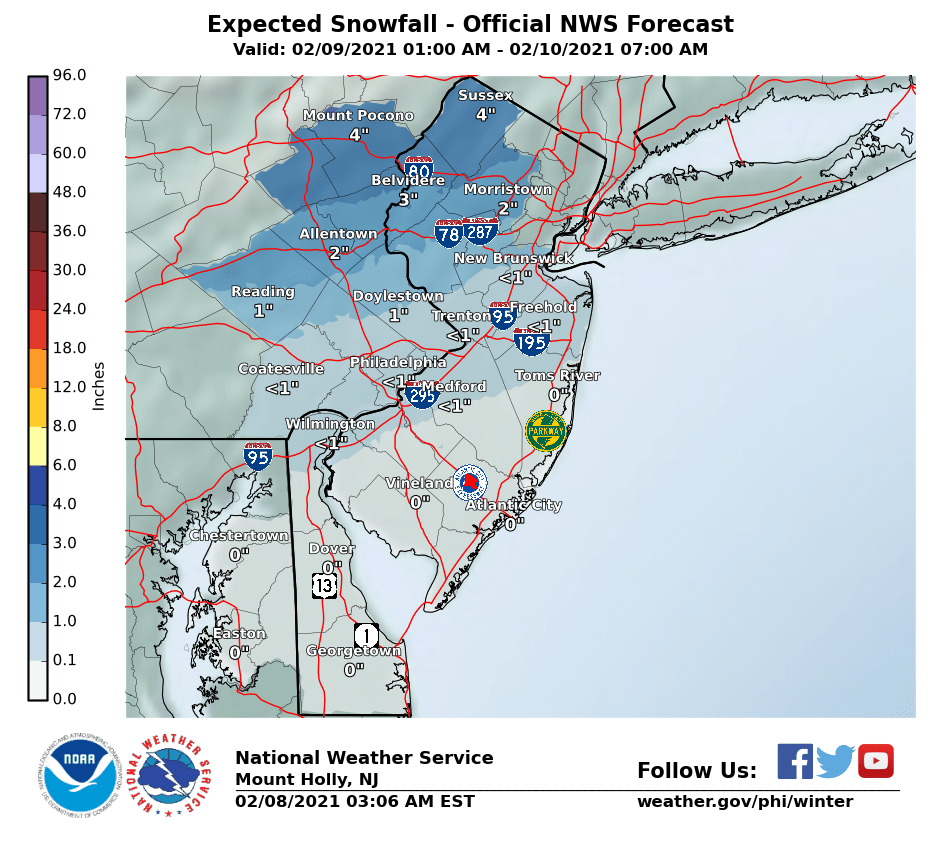
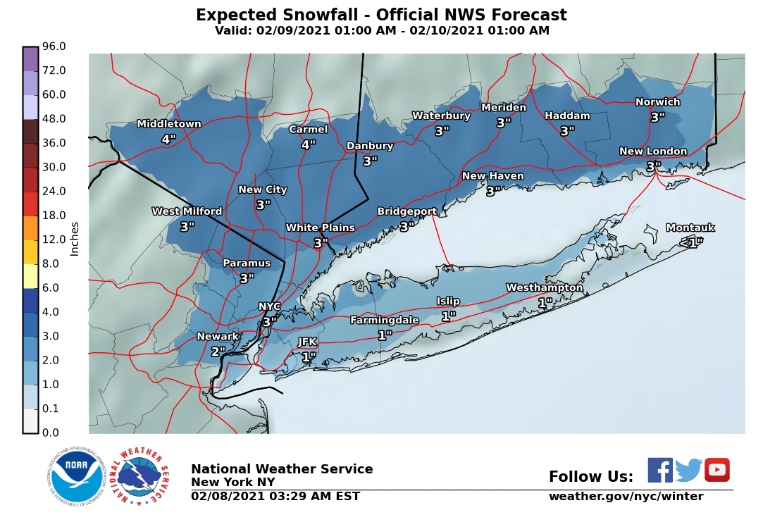
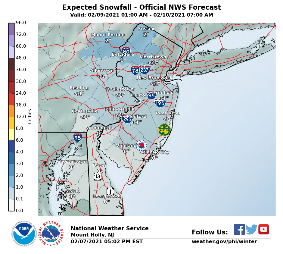
The first threat is fairly minor event on Tuesday with not much moisture to work with, as a storm approaches from the west early Tuesday with precip during the day mostly, kind of like today (but much less) Model variability is huge right now withi everything from nothing for the 95 corridor to a few inches; most models focus the snowfall of a few inches N of 78, as temps might be too warm for snow south of 78. The NWS is calling for <1" south of 78 and 1-2" north of there, but there is the potential for up to 3-4" in some models. See the map below and the storm thread on 33andrain.
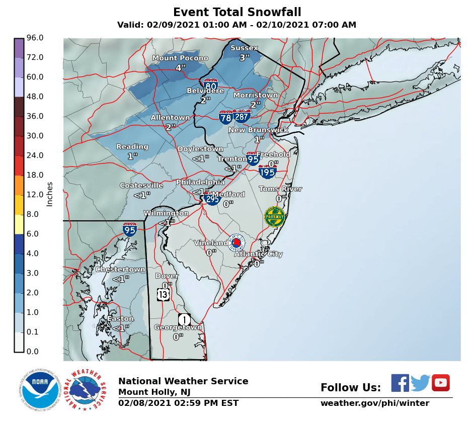
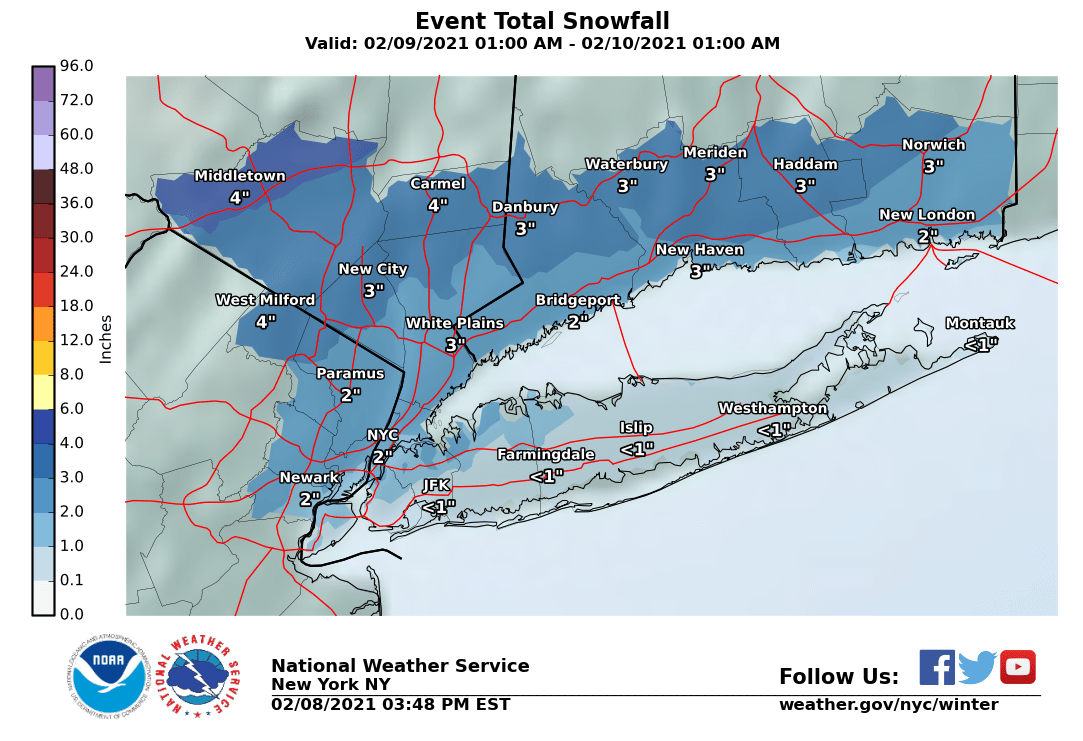
The more substantial threat is a storm that will likely approach from the SW (in a "southwest flow event" or SWFE) bringing a fair amount of wintry precip from the pre-dawn hours on Thursday throughout the day. There will be more cold air to work with for this event and a lot more precip. Right now the models are showing more precip/snow/mix south of 78 with the potential for 6" or more where it's all snow. This could be one of those events with all snow NW of 95, mostly snow near/along 95 and a mix SE of 95 and towards the coast, but it's too far out to speculate on who will get what (4 days out), especially with nowhere near any model consensus, other than to say a winter storm is likely. Stay tuned on that one.
https://www.weather.gov/phi/
https://www.33andrain.com/topic/2021-february-9-2021-northeast-overrunning-light-snow/
https://www.33andrain.com/topic/2010-weather-threats-winter-2020-21-edition-part-ii/
National Weather Service Mount Holly NJ
336 PM EST Sun Feb 7 2021
.SHORT TERM /TUESDAY THROUGH TUESDAY NIGHT/...
The next system is expected to make a quick pass over the region on
Tuesday. There remains a bit of uncertainty as with systems a few
weeks ago, this one will be dependent on a weak northern stream
short wave trough phasing with a southern stream short wave
trough/vorticity maximum. No major changes in the latest update with
this system. It still appears that the best lift will be mostly
northwest of our region, but the southern Poconos and NW NJ will be
cold enough through out the event to remain all snow. Despite modest
QPF amounts, the snow ratios should be enough to support widespread
1 to 2 inches, though amounts above 3 inches are possible especially
if the snow begins late Tuesday night (somewhat uncertain and
dependent on how quickly the two troughs phase).
For the rest of the region, the low level southerly flow will result
in warm air advection leading to the snow (if it starts early enough
to start as snow) changing over to a rain/snow mix, and eventually
all rain. Some guidance does show an elevated warm layer, especially
early on in the day, so I can`t rule out a brief period of freezing
rain and/or sleet, but the period of transition should be brief.
Thus, a glaze of ice will also be possible, but not confident on
that yet.
Much like the timing with today`s storm, precipitation should
quickly move out in the late afternoon and early evening. Clouds may
linger for a while longer though.However, with winds shifting to
northwesterly and cold air advection, leading to low temperatures in
the teens to mid 20s.
Wed night/Thursday/Friday... The next in a string of weather systems
approaches from the south/west as low pressure starts to deepen
across the Tenn. Valley Thu. and tracks towards the Middle Altantic
region by Fri. It appears at this time that enough of the cold air
to the north will be across the area at onset to produce a variety
of winter weather for many areas. It does look like a decent feed of
Gulf of Mexico moisture will be available, so the QPF forecasts may
be notable when it arrives. We will be watching this closely this
week because it may create some impacts for the late week period.
Right now, probably a (mostly) snow event for the N/W areas, a mix
for the Delaware Valley and rain for Delmarva areas. This will, no
doubt, change through the week as the details become clearer. The
latest EC/GFS offer snow for many areas with the CMC waiting until
Fri to produce its precip.
The first threat is fairly minor event on Tuesday with not much moisture to work with, as a storm approaches from the west early Tuesday with precip during the day mostly, kind of like today (but much less) Model variability is huge right now withi everything from nothing for the 95 corridor to a few inches; most models focus the snowfall of a few inches N of 78, as temps might be too warm for snow south of 78. The NWS is calling for <1" south of 78 and 1-2" north of there, but there is the potential for up to 3-4" in some models. See the map below and the storm thread on 33andrain.
The more substantial threat is a storm that will likely approach from the SW (in a "southwest flow event" or SWFE) bringing a fair amount of wintry precip from the pre-dawn hours on Thursday throughout the day. There will be more cold air to work with for this event and a lot more precip. Right now the models are showing more precip/snow/mix south of 78 with the potential for 6" or more where it's all snow. This could be one of those events with all snow NW of 95, mostly snow near/along 95 and a mix SE of 95 and towards the coast, but it's too far out to speculate on who will get what (4 days out), especially with nowhere near any model consensus, other than to say a winter storm is likely. Stay tuned on that one.
https://www.weather.gov/phi/
https://www.33andrain.com/topic/2021-february-9-2021-northeast-overrunning-light-snow/
https://www.33andrain.com/topic/2010-weather-threats-winter-2020-21-edition-part-ii/
National Weather Service Mount Holly NJ
336 PM EST Sun Feb 7 2021
.SHORT TERM /TUESDAY THROUGH TUESDAY NIGHT/...
The next system is expected to make a quick pass over the region on
Tuesday. There remains a bit of uncertainty as with systems a few
weeks ago, this one will be dependent on a weak northern stream
short wave trough phasing with a southern stream short wave
trough/vorticity maximum. No major changes in the latest update with
this system. It still appears that the best lift will be mostly
northwest of our region, but the southern Poconos and NW NJ will be
cold enough through out the event to remain all snow. Despite modest
QPF amounts, the snow ratios should be enough to support widespread
1 to 2 inches, though amounts above 3 inches are possible especially
if the snow begins late Tuesday night (somewhat uncertain and
dependent on how quickly the two troughs phase).
For the rest of the region, the low level southerly flow will result
in warm air advection leading to the snow (if it starts early enough
to start as snow) changing over to a rain/snow mix, and eventually
all rain. Some guidance does show an elevated warm layer, especially
early on in the day, so I can`t rule out a brief period of freezing
rain and/or sleet, but the period of transition should be brief.
Thus, a glaze of ice will also be possible, but not confident on
that yet.
Much like the timing with today`s storm, precipitation should
quickly move out in the late afternoon and early evening. Clouds may
linger for a while longer though.However, with winds shifting to
northwesterly and cold air advection, leading to low temperatures in
the teens to mid 20s.
Wed night/Thursday/Friday... The next in a string of weather systems
approaches from the south/west as low pressure starts to deepen
across the Tenn. Valley Thu. and tracks towards the Middle Altantic
region by Fri. It appears at this time that enough of the cold air
to the north will be across the area at onset to produce a variety
of winter weather for many areas. It does look like a decent feed of
Gulf of Mexico moisture will be available, so the QPF forecasts may
be notable when it arrives. We will be watching this closely this
week because it may create some impacts for the late week period.
Right now, probably a (mostly) snow event for the N/W areas, a mix
for the Delaware Valley and rain for Delmarva areas. This will, no
doubt, change through the week as the details become clearer. The
latest EC/GFS offer snow for many areas with the CMC waiting until
Fri to produce its precip.