

Colleges
- AAC
- ACC
- Big 12
- Big East
- Big Ten
- Pac-12
- SEC
- Atlantic 10
- Conference USA
- Independents
- Junior College
- Mountain West
- Sun Belt
- MAC
- More
- Navy
- UAB
- Tulsa
- UTSA
- Charlotte
- Florida Atlantic
- Temple
- Rice
- East Carolina
- USF
- SMU
- North Texas
- Tulane
- Memphis
- Miami
- Louisville
- Virginia
- Syracuse
- Wake Forest
- Duke
- Boston College
- Virginia Tech
- Georgia Tech
- Pittsburgh
- North Carolina
- North Carolina State
- Clemson
- Florida State
- Cincinnati
- BYU
- Houston
- Iowa State
- Kansas State
- Kansas
- Texas
- Oklahoma State
- TCU
- Texas Tech
- Baylor
- Oklahoma
- UCF
- West Virginia
- Wisconsin
- Penn State
- Ohio State
- Purdue
- Minnesota
- Iowa
- Nebraska
- Illinois
- Indiana
- Rutgers
- Michigan State
- Maryland
- Michigan
- Northwestern
- Arizona State
- Oregon State
- UCLA
- Colorado
- Stanford
- Oregon
- Arizona
- California
- Washington
- USC
- Utah
- Washington State
- Texas A&M
- Auburn
- Mississippi State
- Kentucky
- South Carolina
- Arkansas
- Florida
- Missouri
- Ole Miss
- Alabama
- LSU
- Georgia
- Vanderbilt
- Tennessee
- Louisiana Tech
- New Mexico State
- Middle Tennessee
- Western Kentucky
- UTEP
- Florida International University
High School
- West
- Midwest
- Northeast
- Southeast
- Other
- Alaska
- Arizona
- California
- Colorado
- Nevada
- New Mexico
- Northern California
- Oregon
- Southern California Preps
- Washington
- Edgy Tim
- Indiana
- Kansas
- Nebraska
- Iowa
- Michigan
- Minnesota
- Missouri
- Oklahoma Varsity
- Texas Basketball
- Texas
- Wisconsin
- Delaware
- Maryland
- New Jersey Basketball
- New Jersey
- New York City Basketball
- Ohio
- Pennsylvania
- Greater Cincinnati
- Virginia
- West Virginia Preps
ADVERTISEMENT
Install the app
How to install the app on iOS
Follow along with the video below to see how to install our site as a web app on your home screen.
Note: This feature may not be available in some browsers.
You are using an out of date browser. It may not display this or other websites correctly.
You should upgrade or use an alternative browser.
You should upgrade or use an alternative browser.
OT: Minor Wintry Event Tuesday (2/9); Minor/Moderate Event Likely Thurs (2/11-12) for most
- Thread starter RU848789
- Start date

The coldest air in over a decade is expected in Texas as a major arctic outbreak hits everywhere except Florida. Temps will drop below zero along with snow.

Yup, was talking to my brother in Lincoln on Monday, and they're expecting temps to be as cold as a witch's tatas in a couple of days.The coldest air in over a decade is expected in Texas as a major arctic outbreak hits everywhere except Florida. Temps will drop below zero along with snow.
The NWS-Phillly did just about what I thought they would for the late Weds through Thursday morning system, issuing advisories for all of the counties south of 276/195 (from Philly across to Burlington/Ocean and south of there, where the criterion is 2" for an advisory) for 2-3" of snow, as well as increasing snowfall totals across the board, including for most of CNJ/EPA from 276/195 northward to 78 into the 1-2" range. With temps well below freezing (except in far SE NJ), everything that falls will accumulate on all surfaces, so the Thursday morning commute will likely be impacted. And the 6Z models this morning all are showing similar amounts as last night and what the NWS now has in its map, roughly. So, it's looking like a minor event N of 276/195 and a moderate event south of that line. As of now.
https://www.weather.gov/phi/
https://www.33andrain.com/topic/2024-february-10-14-2021-days-of-wintry-waves/page/7/
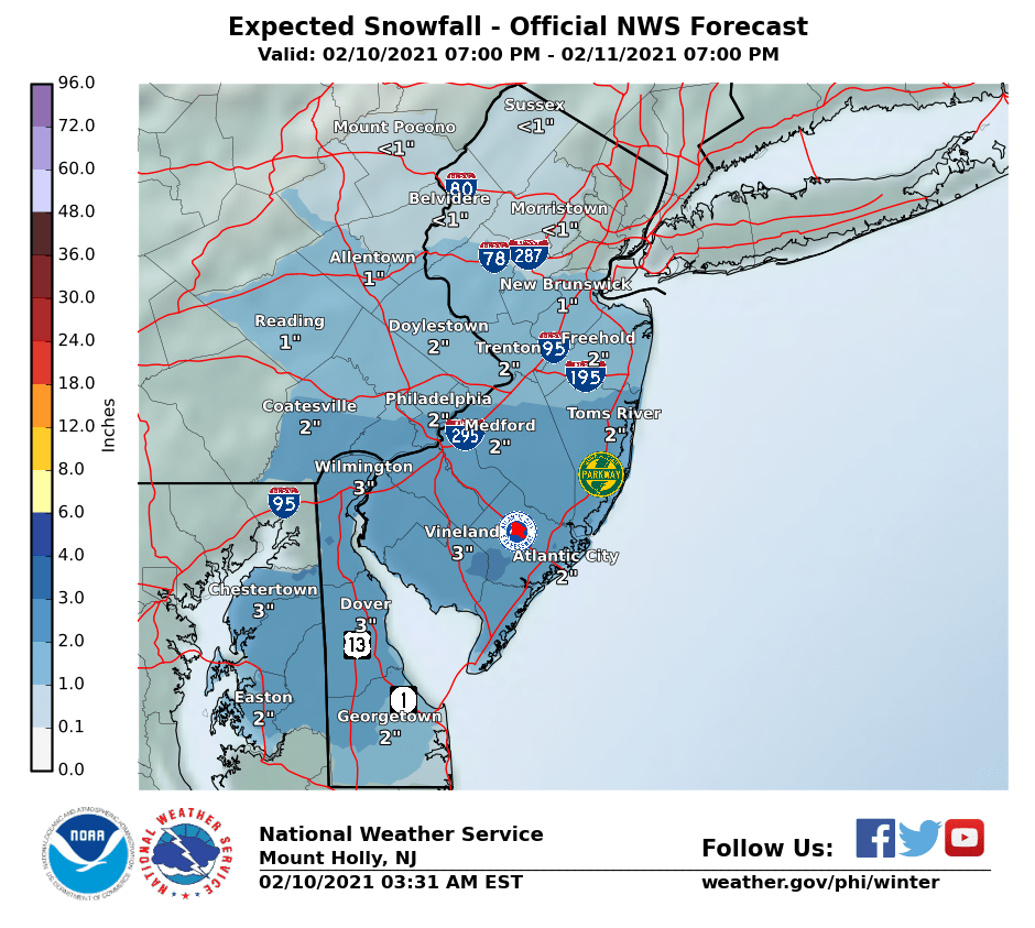
Every model run this morning (data inputs at 7 am EST for the 12Z GMT runs) increased snowfall amounts northward, with the model consensus roughly being a 2-4" snowfall late tonight through tomorrow morning between 78 (roughly the 2" line) and 276/195 (roughly the 4" line) which is up from the 1-2" for this area seen in last night's models and now the NWS forecast for these areas. And snowfall went from <1" north of 80 to 1-2" and snowfall south of 276/195 is in the general 3-5" range for everyone, including the coast down to Cape May as temps will be below 32F, meaning any snow will accumulate, especially before about 9-10 am (before the sun is a factor and most of the snow wlll fall by then).
Good chance the NWS will extend the advisories to the counties between 78 and 276/195 (Hunterdon-Somerset-Mercer-Middlesex-Monmouth in NJ and Bucks/Montco/Berks in PA), where 3" is the advisory criterion (2" south of 276/195), especially given the 100% likelihood of travel impacts due to the cold temps, if 2-4" fall. The warning criterion is 5" for south of 276/195, so not sure if they'll issue warnings there and they're 6" north of 276/195, so warnings won't be issued there. 2-4" would be a moderate event.
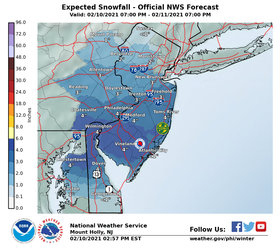
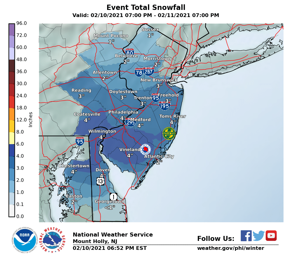
NWS-Philly bumped up snowfall forecasts again vs. this morning, as per the updated map below going with ~2" along/near 78 to 3-4" along/near 276/195, i,e., a general 2-4" forecast for E-PA/CNJ and they extended the advisories northward to include SE Montco/Bucks in PA and Mercer/Middlesex in NJ. In addition snowfall amounts from 78 to 80 were increased to 1-2" and amounts S of 276/195 were bumped up to about 3-5", although warnings were not posted (5" is the warning criterion for those counties).
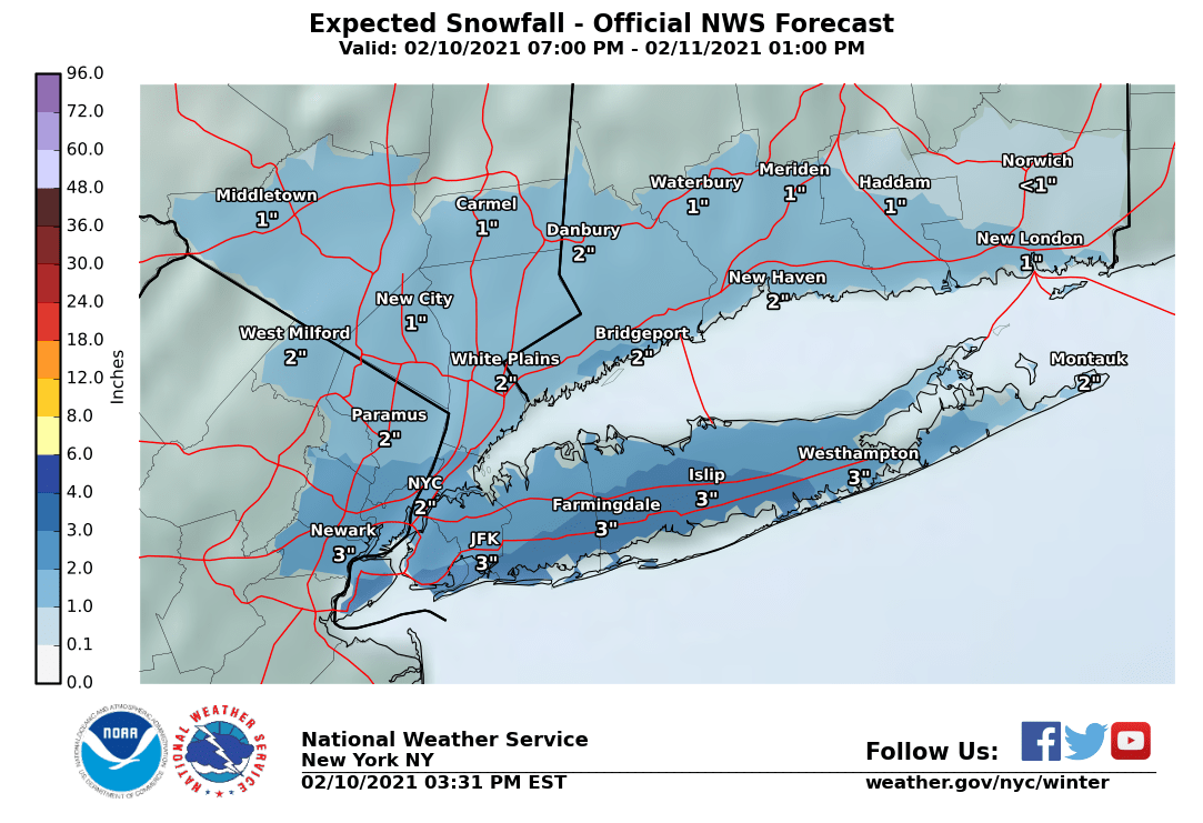
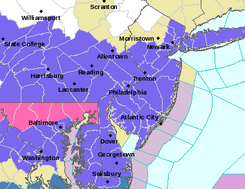
Also, the NWS-NYC put advisories up for all of NENJ (Union up to Bergen) and NYC metro/LI for 2-3" of snow; map is below. A bit surprised they went north of Union/NYC, as adjacent areas of NJ are not under advisories, like Morris/Somerset. They should address that disconnect, IMO. One more reminder: it's going to be well below 32F for the event, from late tonight through Thursday morning, meaning every flake will accumulate on all untreated surfaces (and even some treated ones if rates are high enough), meaning the impact for this 2-4" event will likely be greater than a typical 2-4" event in these parts.
Last edited:

Why not post this in the pattern thread?The coldest air in over a decade is expected in Texas as a major arctic outbreak hits everywhere except Florida. Temps will drop below zero along with snow.
Also, posting things 1-2 hours before the NWS updates their forecasts (they update at 4 am and 4 pm unless there's some late breaking major change) inevitably leads to outdated information being posted like the info above.
Why not post this in the pattern thread?
Also, posting things 1-2 hours before the NWS updates their forecasts (they update at 4 am and 4 pm unless there's some late breaking major change) inevitably leads to outdated information being posted like the info above.
I will try to do better next time
NWS-Philly bumped up snowfall forecasts again vs. this morning, as per the updated map below going with ~2" along/near 78 to 3-4" along/near 276/195, i,e., a general 2-4" forecast for E-PA/CNJ and they extended the advisories northward to include SE Montco/Bucks in PA and Mercer/Middlesex in NJ. In addition snowfall amounts from 78 to 80 were increased to 1-2" and amounts S of 276/195 were bumped up to about 3-5", although warnings were not posted (5" is the warning criterion for those counties).
Also, the NWS-NYC put advisories up for all of NENJ (Union up to Bergen) and NYC metro/LI for 2-3" of snow; map is below. A bit surprised they went north of Union/NYC, as adjacent areas of NJ are not under advisories, like Morris/Somerset. They should address that disconnect, IMO. One more reminder: it's going to be well below 32F for the event, from late tonight through Thursday morning, meaning every flake will accumulate on all untreated surfaces (and even some treated ones if rates are high enough), meaning the impact for this 2-4" event will likely be greater than a typical 2-4" event in these parts.

Why do these maps made the same time have different amounts?

They weren't. The one in this post and my post above was made at 2:57 pm and the one that you posted, which was from the DEM at about 2 pm, included the NWS map from 3:31 am (which I posted at 7:31 am), but I don't think they made that clear in their post. That's not your fault, but knowing that the NWS will come out with new maps usually in the 3-5 am and 3-5 pm timeframes would normally mean a 2 pm map is from 4 am. Make sense?
Why do these maps made the same time have different amounts?
They weren't. The one in this post and my post above was made at 2:57 pm and the one that you posted, which was from the DEM at about 2 pm, included the NWS map from 3:31 am (which I posted at 7:31 am), but I don't think they made that clear in their post. That's not your fault, but knowing that the NWS will come out with new maps usually in the 3-5 am and 3-5 pm timeframes would normally mean a 2 pm map is from 4 am. Make sense?
They both say 02:57 PM EST
My map 02:57 shows 2-3 inches New Brunswick
Your map 02:57 says 3 inches
Why are they different
Last edited:
Thought you were talking about the map in the DEM post from 2:30 pm, which is the map from 3:31 am, which was pretty out of date by then, with a new map coming shortly.They both say 02:57 PM EST
My map 02:57 shows 2-3 inches New Brunswick
Your map 02:57 says 3 inches
Why are they different
With regard to the 2-3" vs single numbers for each location, the NWS puts out both maps and sometimes prints the range keyed to the color swath (2-3") and sometimes they print their "best guess" - in this case, 3" for NB (vs. the 2-3" swath) and also 3" for Freehold (vs. the 3-4" swath they're in) - 3" seems like a good forecast and we've overperformed recently, so I'll go with 3" for my house. I don't know why they do both to be honest. I like the single numbers along with the general swath, which is what I always post, from their "winter weather" page, whereas the one with ranges is usually from their home page.
https://www.weather.gov/phi/winter
Last edited:
Yup, was talking to my brother in Lincoln on Monday, and they're expecting temps to be as cold as a witch's tatas in a couple of days.
cold in Wichita too.
cold in Wichita too.
I hope the Wichita lineman is *not* on the line in this weather!
I hope the Wichita lineman is *not* on the line in this weather!
NWS-Philly bumped up snowfall forecasts again vs. this morning, as per the updated map below going with ~2" along/near 78 to 3-4" along/near 276/195, i,e., a general 2-4" forecast for E-PA/CNJ and they extended the advisories northward to include SE Montco/Bucks in PA and Mercer/Middlesex in NJ. In addition snowfall amounts from 78 to 80 were increased to 1-2" and amounts S of 276/195 were bumped up to about 3-5", although warnings were not posted (5" is the warning criterion for those counties).
Also, the NWS-NYC put advisories up for all of NENJ (Union up to Bergen) and NYC metro/LI for 2-3" of snow; map is below. A bit surprised they went north of Union/NYC, as adjacent areas of NJ are not under advisories, like Morris/Somerset. They should address that disconnect, IMO. One more reminder: it's going to be well below 32F for the event, from late tonight through Thursday morning, meaning every flake will accumulate on all untreated surfaces (and even some treated ones if rates are high enough), meaning the impact for this 2-4" event will likely be greater than a typical 2-4" event in these parts.
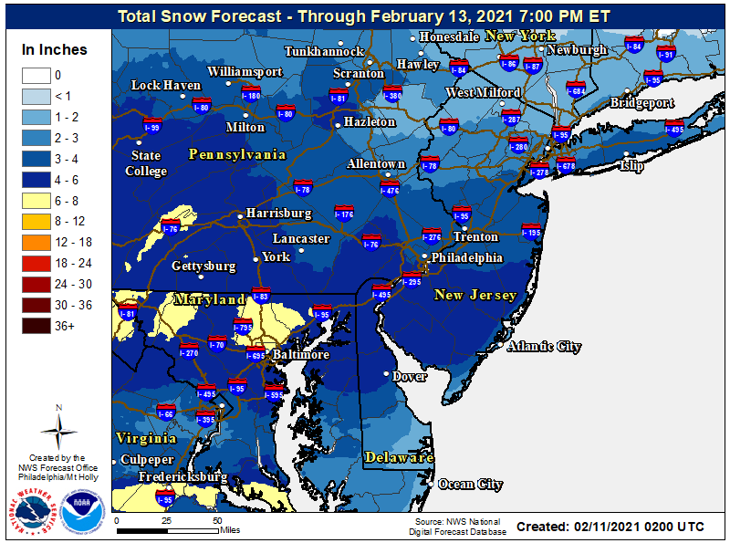
Another minor bump up in snowfall amounts by the NWS-Philly, moving the 2" and 3" lines 10-15 miles further north and adding Somerset, Hunterdon, NW Bucks/NW Montco and Lehigh/Northampton to the advisories for 2-4" of snow - as I said above, they had to address that disconnect in the maps between them and NWS-NYC.
edit: here's the regional NWS snowfall map...
Last edited:
So we are going with 4" solidly all over Philly?Another minor bump up in snowfall amounts by the NWS-Philly, moving the 2" and 3" lines 10-15 miles further north and adding Somerset, Hunterdon, NW Bucks/NW Montco and Lehigh/Northampton to the advisories for 2-4" of snow - as I said above, they had to address that disconnect in the maps between them and NWS-NYC.
Yes, if the precip comes. Very had to predict the Airport only getting 1.7" while other parts of the city got 4-6" in the last storm - heat island and elevation differences in a very borderline temp situation. No issue like that tomorrow, as snow will accumulate wherever it falls - if they don't get 4" nobody near them gets 4" either.So we are going with 4" solidly all over Philly?
Last Airport report I saw was .7 there was no way they added an inch after that! Looks like Delaware will get more for a change. It will be cold enough!Yes, if the precip comes. Very had to predict the Airport only getting 1.7" while other parts of the city got 4-6" in the last storm - heat island and elevation differences in a very borderline temp situation. No issue like that tomorrow, as snow will accumulate wherever it falls - if they don't get 4" nobody near them gets 4" either.
And so it begins. Light snow started around 10:50 pm and we have a light dusting. 30F here in Metuchen.
Last Airport report I saw was .7 there was no way they added an inch after that! Looks like Delaware will get more for a change. It will be cold enough!
Final report shows 1.7" at the Airport...
...Philadelphia County...
Chestnut Hill 6.0 in 0230 PM 02/07 Public
1 SW Somerton 3.5 in 0224 PM 02/07 Fire Dept/Rescue
Fox Chase 3.0 in 0330 PM 02/07 Trained Spotter
Philadelphia International 1.7 in 0700 PM 02/07 ASOS
the HRRR doesnt seem so enthused and has it over by 8
The ending time seems to depend where you are. In Flemington, it's supposed to end by 9; in Cherry Hill, by 1.
As of 12:00 am we have 1/2" of pixie dust (small, dry, thin plates, not big dendrites, so maybe 10:1 ratio snow) on the ground here in Metuchen at 30F. Coming down nicely - 6 hours of this gets us 3".And so it begins. Light snow started around 10:50 pm and we have a light dusting. 30F here in Metuchen.
HRRR has been horrible lately. Unless the radar just dries up unexpectedly, everyone along/south of 78 should have 2" by 2-3 am.the HRRR doesnt seem so enthused and has it over by 8
Snow picked up in intensity significantly the last half hour and we now have moderately sized dendrites that likely will give 15-20: ratios. Up to 1.0" at 12:30, which is a 1"/hr rate over the last 30 min. Temp has dropped to 28FAs of 12:00 am we have 1/2" of pixie dust (small, dry, thin plates, not big dendrites, so maybe 10:1 ratio snow) on the ground here in Metuchen at 30F. Coming down nicely - 6 hours of this gets us 3".
Snow picked up in intensity significantly the last half hour and we now have moderately sized dendrites that likely will give 15-20: ratios. Up to 1.0" at 12:30, which is a 1"/hr rate over the last 30 min. Temp has dropped to 28F
Just went for a walk - stunningly gorgeous out there right now in the absolute quiet of the middle of the night with a fresh blanket of white. Up to 1.5" in Metuchen as of 1:00 am, as it's still snowing moderately with nice small/medium dendrites - this stuff is like cotton candy, so a broom will work to clear it. Seems pretty likely we'll make it to 2.5", but not sure how much more snow we'll get after about 2:30 am. I could see 3-4" and with even 3-4 hours of lighter snow after this band finishes coming through in the next 30 min or so.
Not a single station in NJ (or even DE) above 32F, so I assume this is all snow for everyone which is nice for the folks in SNJ who like snow and missed out so far.
As of about 2 am, we have 2.25" OTG at 28F in Metuchen. That's 3/4" the last hour and radar/intensity have let up a bit, but I'd still guess we have 1/4-1/2" per hour snow. Hoping we make it to my 3" prediction for my house, which we should as long as the precip from PA doesn't dry up - it's on the lighter side, but a few hours would do it.
Heading out to do my commercial lots. I don't even know how much is out there in Hillsborough. Looks like maybe 2 inches at 4:30.
Thought I posted at 2:45 am with 2.5" - guess it didn't take, lol. Anyway, went to sleep then and woke up at 7 am and took a final measurement of 2.75", as we only got 1/4" since 2:45 am, which looks about right, looking at the radar history since then. Very pretty snowfall, since it wasn't windy and everything is still covered. Down to 25F, so be careful out there. Brings my seasonal total to 36.0".As of about 2 am, we have 2.25" OTG at 28F in Metuchen. That's 3/4" the last hour and radar/intensity have let up a bit, but I'd still guess we have 1/4-1/2" per hour snow. Hoping we make it to my 3" prediction for my house, which we should as long as the precip from PA doesn't dry up - it's on the lighter side, but a few hours would do it.
Just stopped snowing here, Looking outside it appears we got more than the 1-2" predicted. Brings the season total to perhaps 8".
The total will not come near the record for the date,set in the storm of 1983.When the wind changed that Friday afternoon,I bailed out of work at 1.The suddenness of the storm overwhelmed the road crews.I heard stories of people driving into deep snow on Route 3.The storm cost me the chance to cash a huge bet as the Meadowlands canceled that night.When the horse that I was following raced the following week,I did not bet.It paid $228 for a deuce.
Yup, was talking to my brother in Lincoln on Monday, and they're expecting temps to be as cold as a witch's tatas in a couple of days.
Ice storm in Forth Worth caused a 100+ car pile up this morning, At least 3 dead.
At least 3 killed in massive car pileup in Texas that left drivers trapped in vehicles - CBS News
In Little Rock Arkansas we received a half inch of sleet last night!
I fell and busted my ass on the deck last night tying to see it coming down. Yes, alcohol was involved.
I fell and busted my ass on the deck last night tying to see it coming down. Yes, alcohol was involved.
Similar threads
- Replies
- 62
- Views
- 2K
- Replies
- 608
- Views
- 17K
OT: Minor to Moderate (2-4?) Snowfall Likely Sat morning (2/17); will be <32F, so expect slick roads
- Replies
- 213
- Views
- 5K
- Replies
- 592
- Views
- 15K
ADVERTISEMENT
Latest posts
-
-
-
With the portal now open, does Gavin Wimsatt enter after the spring game?
- Latest: Nycrusupporter
ADVERTISEMENT