I don't think there is a second punch. I think we see intermittent sleet rest of daylight. That mixes to intermittent sleet/snow overnight with maybe another inch or so through the morning. Travel problems should improve tonight and be fine thereafter.so IF we get a 2nd punch whats the timing on that?


Colleges
- American Athletic
- Atlantic Coast
- Big 12
- Big East
- Big Ten
- Colonial
- Conference USA
- Independents (FBS)
- Junior College
- Mountain West
- Northeast
- Pac-12
- Patriot League
- Pioneer League
- Southeastern
- Sun Belt
- Army
- Charlotte
- East Carolina
- Florida Atlantic
- Memphis
- Navy
- North Texas
- Rice
- South Florida
- Temple
- Tulane
- Tulsa
- UAB
- UTSA
- Boston College
- California
- Clemson
- Duke
- Florida State
- Georgia Tech
- Louisville
- Miami (FL)
- North Carolina
- North Carolina State
- Pittsburgh
- Southern Methodist
- Stanford
- Syracuse
- Virginia
- Virginia Tech
- Wake Forest
- Arizona
- Arizona State
- Baylor
- Brigham Young
- Cincinnati
- Colorado
- Houston
- Iowa State
- Kansas
- Kansas State
- Oklahoma State
- TCU
- Texas Tech
- UCF
- Utah
- West Virginia
- Illinois
- Indiana
- Iowa
- Maryland
- Michigan
- Michigan State
- Minnesota
- Nebraska
- Northwestern
- Ohio State
- Oregon
- Penn State
- Purdue
- Rutgers
- UCLA
- USC
- Washington
- Wisconsin
High School
- Illinois HS Sports
- Indiana HS Sports
- Iowa HS Sports
- Kansas HS Sports
- Michigan HS Sports
- Minnesota HS Sports
- Missouri HS Sports
- Nebraska HS Sports
- Oklahoma HS Sports
- Texas HS Hoops
- Texas HS Sports
- Wisconsin HS Sports
- Cincinnati HS Sports
- Delaware
- Maryland HS Sports
- New Jersey HS Hoops
- New Jersey HS Sports
- NYC HS Hoops
- Ohio HS Sports
- Pennsylvania HS Sports
- Virginia HS Sports
- West Virginia HS Sports
ADVERTISEMENT
Install the app
How to install the app on iOS
Follow along with the video below to see how to install our site as a web app on your home screen.
Note: This feature may not be available in some browsers.
You are using an out of date browser. It may not display this or other websites correctly.
You should upgrade or use an alternative browser.
You should upgrade or use an alternative browser.
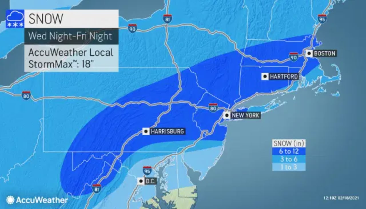
OT: Significant Winter Storm Likely on Thursday (2/18)
- Thread starter RU848789
- Start date

I know how much you love snow, so I'm going to try to make you jealous. When I was Stationed at a USAFSS site for 20 months, we had 275 inches of snow the firstWe got about 8" of heavy wet snow during that storm. Thought we were going to lose power again, but didn't...
Winter and 290 inches the second.
Dummies Guide to Feb. 18 Snow
(6th grade reading level)
Is there a second wave coming ?
Where?
When?
How much?
(brief answers and baby words, please.)
Asking for a friend.
(6th grade reading level)
Is there a second wave coming ?
Where?
When?
How much?
(brief answers and baby words, please.)
Asking for a friend.
I don't think there is a second punch. I think we see intermittent sleet rest of daylight. That mixes to intermittent sleet/snow overnight with maybe another inch or so through the morning. Travel problems should improve tonight and be fine thereafter.
yeah it seems like those 2nd batches never quite work out
Nope - exactly why I bought a generator and wired it into the house and also keep a small stockpile of gas on hand. I’ve only had to use it a few times but was glad I had it when Sandy killed power for 5 days.Can you live in a home that's 30 degrees inside with no power or running water?
With young kids, infants, elderly?
One of the energy waves almost always becomes the dominant one and saps the secondary one. In this case the first wave appears to have been more robust from a QPF standpoint which leads me to believe there won't be a second round outside of snow or sleet showers.
Dummies Guide to Feb. 18 Snow
(6th grade reading level)
Is there a second wave coming ?
Sortve
Where?
Statewide, favoring eastern parts
When?
Tonight and tomorrow
How much?
(brief answers and baby words, please.)
Asking for a friend.
Just drove back from Elizabeth to Metuchen with my son, after stopping for White Castle of course and it was snow until about Woodbridge, when I heard pinging on the windshield and I thought, no damn this can't be sleet already as the met on 1010 WINS said the sleet line was in Manasquan. Sounds like it was more like rimed snow (with supercooled liquid that crystallizes as ice on snowflakes, making them kind of large and hard) - didn't see the classic small discrete perfectly formed sleet pellets (usually somewhat cubic) that were clear ice and they definitely made noise like sleet - have only seen that a few times. From what I heard we had a fair amount of that rimed snow, but also sleet while I was gone.
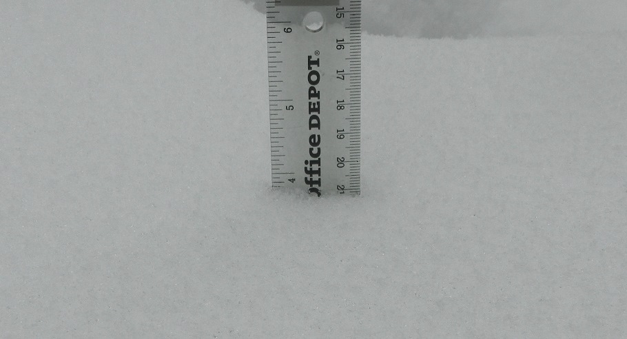
Had 2.25" at 10 am and now have 3.5" at noon, which is only 1.25" in the last 2 hours - if that had been all snow, it would have been 2-3"+, looking at the radar intensity. Oh well, still a cool storm with more to go. Currently a mix of sleet and snow.
Did some "forensics" and closely inspected the snow "column" and I have about 3" of snow underneath about 1/2" of the mixed rimed snow/sleet (was definitely looking like pure sleet in there and others have said we had sleet while I was gone). If that layer is ~3:1 like most sleet, then 1/2" of it is about 1.6" of 10:1 snow, meaning I would have had about 4.6" of snow if it had been all regular snow, which makes more sense. Right now it keeps going back and forth between pure sleet (I checked it closely and it's sleet) and giant aggregates of snowflakes - if we could get an hour of these aggregates, we'd accumulate pretty quickly, but I have no clue what we're going to get for the next 1-2 hours whlie we're still getting decent precip. I did predict "3.5" of snow, then 1" of sleet (3" snow equivalent) on Thursday, then 1.5" of snow on Friday over a long period" yesterday for my house, which could end up being close.
Just looked outside, is it already over?yeah it seems like those 2nd batches never quite work out
2nd batch?? We don't need no stinking 2nd batch!!yeah it seems like those 2nd batches never quite work out
South Brunswick here too. Just came in from Round 1 shoveling, about 3 inches on the ground and now mixing with sleet.i hear the beginning of some mixed precip here in south brunswick
Already did.When is the heavy stuff in CNJ supposed to end?
Don't care. LOL.not here.
No snow here for at least 45-60 mins.
Hey I noticed the message in your avatar. What about someone working on lasers?
One has to consider that there may be exceptions to certain rules. Some of them involve common sense, such as not staring at the sun during an eclipse--or other times for that matter. 😎😎
Here it is (seems like they overshot this one a bit)what was the weatherworks forecast?
Very heavy band south | Mixing coming faster... A relatively narrow band of very heavy snow affected the southern half of Mercer County and extreme southern Middlesex County as this storm came in between 5:00 and 7:30 AM. Where this occurred, earlier initial 1-2" per hour snow rates will likely lead to final totals over 7" in those areas. Further north, snow is now starting to get heavier and we'll see accumulation increasing here as we progress through the morning. The other notable change in the forecast is the potential to start mixing with sleet earlier. We've already had reports in Mount Holly where sleet has been mixing in. This moves north through the morning as a wintry mix is likely by midday. Note that it may fluctuate more sleet vs more snow from 11 AM to 3 PM before a more pronounced change to sleet and freezing rain. Regardless, this will lead to removal challenges until the mix gets lighter late afternoon and especially after sunset.
OVERVIEW
End Time
Friday
11:00 AM - 2:00 PM
Perhaps a few wrap around snow showers
4.0 - 7.0"
Snow/Sleet
plus a coating of ice
2.0 - 4.0" --- 20%
4.0 - 7.0" --- 45%
7.0 - 10.0" --- 30%
10.0 - 12.0" --- 5%
Dude, don't say something to be cute, I asked for a reason and wanted a legit answer.Don't care. LOL.
No snow here for at least 45-60 mins.
Public Information Statement
National Weather Service Mount Holly NJ
100 PM EST Thu Feb 18 2021
...SNOWFALL REPORTS PAST 6 HOURS...
Location Amount Time/Date Provider
...Delaware...
...Kent County...
Woodside 1.0 in 1212 PM 02/18 Trained Spotter
1 SSE Woodside 0.8 in 1142 AM 02/18 Trained Spotter
...New Castle County...
Hockessin 2.8 in 1220 PM 02/18 Trained Spotter
New Castle County Airport 0.1 in 0700 AM 02/18 ASOS
1 ESE Woodshade 0.1 in 0712 AM 02/18 Public
...New Jersey...
...Atlantic County...
Pleasantville 0.4 in 1227 PM 02/18 Broadcast Media
...Burlington County...
Bordentown 5.5 in 1110 AM 02/18 Trained Spotter
Florence 5.2 in 1000 AM 02/18 Trained Spotter
1 ENE Westampton Twp 2.4 in 1200 PM 02/18 Official NWS Obs
1 ESE Delran 2.1 in 0710 AM 02/18 Trained Spotter
1 WNW South Jersey Regional 2.1 in 1230 PM 02/18 NWS Employee
Mount Laurel 1.7 in 1005 AM 02/18 Trained Spotter
Cinnaminson 1.2 in 0814 AM 02/18 Public
1 NE Marlton 0.7 in 1100 AM 02/18 Public
1 ESE Leisuretowne 0.5 in 1028 AM 02/18 Trained Spotter
...Camden County...
Lindenwold 1.7 in 1249 PM 02/18 Trained Spotter
...Gloucester County...
West Deptford Twp 2.0 in 1200 PM 02/18 Public
Williamstown 1.7 in 1212 PM 02/18 Amateur Radio
2 W Pitman 0.3 in 0927 AM 02/18 Trained Spotter
...Hunterdon County...
Whitehouse Station 4.0 in 1151 AM 02/18 Trained Spotter
Readington Twp 2.8 in 1200 PM 02/18 Trained Spotter
...Mercer County...
Trenton 8.0 in 1048 AM 02/18 Public
Hamilton Square 8.0 in 1150 AM 02/18 Trained Spotter
East Windsor Twp 7.5 in 1214 PM 02/18 Trained Spotter
1 SE Robbinsville Twp. 6.7 in 0933 AM 02/18 Public
2 W Yardville 6.0 in 0808 AM 02/18 Public
Robbinsville Twp. 6.0 in 0915 AM 02/18 Trained Spotter
Trenton Mercer Airport 6.0 in 1100 AM 02/18 Trained Spotter
Ewing 5.5 in 1247 PM 02/18 Trained Spotter
Hightstown 4.6 in 0700 AM 02/18 CO-OP Observer
Hopewell 3.3 in 1130 AM 02/18 Trained Spotter
Princeton 3.0 in 1119 AM 02/18 Public
Yardville 2.9 in 0723 AM 02/18 Public
3 NW Pennington 2.8 in 1030 AM 02/18 Trained Spotter
...Middlesex County...
Manalapan Twp 7.5 in 1209 PM 02/18 Trained Spotter
Old Bridge 5.3 in 1230 PM 02/18 Trained Spotter
Cranbury 4.7 in 1213 PM 02/18 Trained Spotter
Metuchen 3.5 in 1230 PM 02/18 Trained Spotter
South Plainfield 3.0 in 1113 AM 02/18 Trained Spotter
Carteret 3.0 in 1230 PM 02/18 Trained Spotter
Edison 2.8 in 1119 AM 02/18 Public
...Monmouth County...
1 ESE Manalapan Township 7.5 in 1142 AM 02/18 Public
Eatontown 7.0 in 1219 PM 02/18 Public
Lincroft 6.5 in 1045 AM 02/18 Public
Manalapan Township 5.1 in 1120 AM 02/18 Trained Spotter
2 N Tinton Falls 5.0 in 0839 AM 02/18 Public
1 NW Sea Bright 5.0 in 1019 AM 02/18 Public
Freehold 4.5 in 1100 AM 02/18 Trained Spotter
Aberdeen 4.0 in 1155 AM 02/18 Trained Spotter
Freehold Twp 3.4 in 0913 AM 02/18 Trained Spotter
Howell 2.3 in 1143 AM 02/18 Public
Strathmore 2.0 in 0900 AM 02/18 Trained Spotter
...Morris County...
2 NNE Brookside 3.8 in 1253 PM 02/18 Trained Spotter
Marcella 3.5 in 1215 PM 02/18 Trained Spotter
Lake Hopatcong 3.2 in 1214 PM 02/18 Trained Spotter
Randolph 3.0 in 1113 AM 02/18 Trained Spotter
...Ocean County...
Brick 3.2 in 1131 AM 02/18 Public
Jackson 3.0 in 1221 PM 02/18 Trained Spotter
Point Pleasant 2.5 in 1136 AM 02/18 Public
1 ESE Manahawkin 0.8 in 1230 PM 02/18 Trained Spotter
...Somerset County...
Basking Ridge 4.0 in 1140 AM 02/18 Public
Branchburg Twp 3.8 in 1214 PM 02/18 Public
Bridgewater 3.5 in 1136 AM 02/18 Public
Warren 3.5 in 1138 AM 02/18 Public
1 ENE Warren 3.5 in 1230 PM 02/18 Trained Spotter
Somerville 3.1 in 1215 PM 02/18 Trained Spotter
2 NW Bridgewater 3.0 in 1100 AM 02/18 Public
Manville 3.0 in 1100 AM 02/18 Public
3 NNW Bridgewater 2.9 in 1153 AM 02/18 Cocorahs
...Sussex County...
Byram 3.0 in 1146 AM 02/18 Public
...Warren County...
Stewartsville 3.6 in 1145 AM 02/18 Trained Spotter
Hackettstown 3.5 in 1159 AM 02/18 Trained Spotter
Blairstown 2.5 in 1234 PM 02/18 Cocorahs
...Pennsylvania...
...Berks County...
Mertztown 4.5 in 1156 AM 02/18 Trained Spotter
Huffs Church 4.3 in 1100 AM 02/18 Trained Spotter
Spring Twp 4.0 in 1037 AM 02/18 Public
Bern Twp 4.0 in 1204 PM 02/18 Trained Spotter
1 N Union Twp 3.6 in 1230 PM 02/18 Public
Morgantown 3.0 in 1000 AM 02/18 Public
1 ENE Hamburg 2.0 in 1019 AM 02/18 Public
...Bucks County...
Feasterville-Trevose 8.8 in 1045 AM 02/18 Public
Morrisville 8.0 in 1255 PM 02/18 Trained Spotter
Langhorne 7.9 in 1200 PM 02/18 Public
1 NNW Eddington 7.0 in 1000 AM 02/18 Public
Morrisville 6.5 in 0830 AM 02/18 Trained Spotter
Lower Makefield Twp 6.5 in 1000 AM 02/18 Public
1 W Levittown 6.0 in 0809 AM 02/18 Public
Fairless Hills 6.0 in 1046 AM 02/18 Public
Newtown 5.5 in 0848 AM 02/18 Public
Bensalem 5.5 in 0914 AM 02/18 Trained Spotter
Warminster 5.0 in 0939 AM 02/18 Trained Spotter
Richboro 4.5 in 0906 AM 02/18 Public
Chalfont 3.9 in 1110 AM 02/18 Trained Spotter
West Rockhill Twp 3.9 in 1218 PM 02/18 Public
Furlong 3.7 in 1145 AM 02/18 Trained Spotter
2 ESE Newtown 3.5 in 0700 AM 02/18 Cocorahs
Newtown Grant 3.1 in 1059 AM 02/18 Public
2 W Jamison 3.0 in 1030 AM 02/18 Public
New Hope 2.7 in 1124 AM 02/18 Trained Spotter
Sellersville 2.5 in 0952 AM 02/18 Trained Spotter
Bristol 2.3 in 0849 AM 02/18 Public
Quakertown 2.3 in 1000 AM 02/18 Trained Spotter
Trumbauersville 2.2 in 1107 AM 02/18 Trained Spotter
...Carbon County...
Lower Towamensing Twp 2.0 in 1140 AM 02/18 Trained Spotter
2 S Meckesville 0.5 in 0941 AM 02/18 Trained Spotter
...Chester County...
Malvern 9.0 in 0950 AM 02/18 Public
2 N East Goshen Twp. 8.0 in 0944 AM 02/18 Public
West Goshen 8.0 in 1000 AM 02/18 Public
Downington 8.0 in 1108 AM 02/18 Public
East Goshen Twp. 8.0 in 1111 AM 02/18 Public
East Fallowfield Twp 7.8 in 0942 AM 02/18 Public
2 SE Exton 7.7 in 1206 PM 02/18 Trained Spotter
Paoli 7.5 in 0900 AM 02/18 Trained Spotter
East Brandywine Twp 7.5 in 0948 AM 02/18 Public
West Bradford Twp 7.5 in 1115 AM 02/18 Public
Parkesburg 7.3 in 1017 AM 02/18 Public
Berwyn 7.0 in 0800 AM 02/18 Public
Exton 7.0 in 0900 AM 02/18 Trained Spotter
1 WNW Uwchlan Twp 7.0 in 1030 AM 02/18 Public
Caln Twp 7.0 in 1116 AM 02/18 Public
East Nantmeal Twp 6.5 in 1055 AM 02/18 Trained Spotter
Uwchlan Twp 6.0 in 0950 AM 02/18 Trained Spotter
2 S East Nantmeal Twp 6.0 in 1100 AM 02/18 Trained Spotter
Schuylkill Twp 6.0 in 1100 AM 02/18 Public
West Caln Twp 5.8 in 1230 PM 02/18 Trained Spotter
Phoenixville 5.6 in 1000 AM 02/18 Public
Pughtown 5.4 in 1118 AM 02/18 Public
East Coventry Twp 3.8 in 1147 AM 02/18 Trained Spotter
2 S Wallace Twp 3.5 in 0900 AM 02/18 Trained Spotter
Oxford 3.5 in 1203 PM 02/18 Public
New London Twp. 3.5 in 1228 PM 02/18 Public
Spring City 3.0 in 0905 AM 02/18 Public
Jennersville 2.6 in 0945 AM 02/18 Public
West Chester 2.1 in 1000 AM 02/18 Trained Spotter
Lincoln University 1.1 in 0830 AM 02/18 Public
...Delaware County...
Wayne 10.2 in 1245 PM 02/18 Trained Spotter
Villanova 5.0 in 1041 AM 02/18 Public
Folsom 4.0 in 1132 AM 02/18 Public
Chadds Ford Twp 3.5 in 1100 AM 02/18 Trained Spotter
Clifton Heights 3.0 in 0700 AM 02/18 Public
Brookhaven 3.0 in 1026 AM 02/18 Public
Upper Darby 3.0 in 1109 AM 02/18 Public
Glen Mills 3.0 in 1220 PM 02/18 NWS Employee
1 NE Lawrence Park 2.5 in 0930 AM 02/18 Public
Upper Chichester Twp 2.5 in 1202 PM 02/18 Trained Spotter
1 E Upper Chichester Twp 2.0 in 1031 AM 02/18 Public
Morton 2.0 in 1123 AM 02/18 Trained Spotter
...Lehigh County...
Coopersburg 4.2 in 1207 PM 02/18 Trained Spotter
Whitehall Twp 3.7 in 1130 AM 02/18 Trained Spotter
Emmaus 3.6 in 1035 AM 02/18 Trained Spotter
New Tripoli 3.3 in 1215 PM 02/18 Trained Spotter
2 ESE Lehigh Valley Internat 3.0 in 1050 AM 02/18 Trained Spotter
Breinigsville 2.8 in 1020 AM 02/18 Public
Coplay 2.6 in 1159 AM 02/18 Trained Spotter
Lehigh Valley International 0.2 in 0700 AM 02/18 ASOS
...Montgomery County...
Norristown 10.2 in 1150 AM 02/18 Trained Spotter
Abington 10.0 in 1156 AM 02/18 Public
King of Prussia 9.3 in 1213 PM 02/18 Trained Spotter
2 WNW Lower Moreland Twp 8.5 in 1105 AM 02/18 Public
1 E Willow Grove 8.0 in 1100 AM 02/18 Trained Spotter
1 NW Whitemarsh Twp 7.8 in 1000 AM 02/18 Public
Glenside 7.3 in 0941 AM 02/18 Public
Valley Forge 7.0 in 1040 AM 02/18 Trained Spotter
Bryn Mawr 7.0 in 1136 AM 02/18 Public
Plymouth Meeting 6.5 in 1234 PM 02/18 Trained Spotter
1 ENE Elkins Park 6.3 in 1117 AM 02/18 Public
Conshohocken 6.0 in 0858 AM 02/18 Public
West Norriton 6.0 in 1125 AM 02/18 Public
Horsham 5.5 in 1055 AM 02/18 Public
Hatboro 5.0 in 0848 AM 02/18 Public
1 W Ambler 5.0 in 0907 AM 02/18 Trained Spotter
Eagleville 4.8 in 1128 AM 02/18 Trained Spotter
Elkins Park 4.0 in 0730 AM 02/18 Public
Jenkintown 4.0 in 0814 AM 02/18 Public
Blue Bell 4.0 in 0832 AM 02/18 Public
3 N Royersford 3.8 in 1100 AM 02/18 NWS Employee
New Hanover Twp 3.6 in 1217 PM 02/18 Trained Spotter
Skippack Twp 3.5 in 1041 AM 02/18 Trained Spotter
Lower Frederick Twp 3.5 in 1125 AM 02/18 Trained Spotter
Pottstown 3.3 in 1057 AM 02/18 Public
Bala Cynwyd 3.2 in 1000 AM 02/18 Public
Lansdale 3.0 in 0945 AM 02/18 Trained Spotter
1 S Gilbertsville 3.0 in 1048 AM 02/18 Public
Telford 2.7 in 1125 AM 02/18 Trained Spotter
Haverford 2.7 in 1206 PM 02/18 Trained Spotter
Ambler 0.3 in 0800 AM 02/18 CO-OP Observer
...Northampton County...
Hanover Twp 4.0 in 1212 PM 02/18 Public
Easton 3.9 in 1111 AM 02/18 Public
Nazareth 3.6 in 1142 AM 02/18 Public
Eastlawn Gardens 3.3 in 1245 PM 02/18 Trained Spotter
Forks Twp 3.0 in 1100 AM 02/18 Public
Bushkill Twp 2.8 in 1200 PM 02/18 Trained Spotter
Martins Creek 2.7 in 1132 AM 02/18 Trained Spotter
Palmer Heights 2.3 in 1045 AM 02/18 Public
...Philadelphia County...
Mount Airy 5.5 in 0930 AM 02/18 Public
Northeast Philadelphia 5.5 in 1140 AM 02/18 Public
Philadelphia 2.8 in 1152 AM 02/18 Public
Manayunk 2.5 in 0815 AM 02/18 Trained Spotter
1 SE Point Breeze 2.3 in 1059 AM 02/18 Trained Spotter
Fox Chase 2.2 in 0905 AM 02/18 Trained Spotter
null Philadelphia Internati 0.6 in 0700 AM 02/18 ASOS
...FREEZING RAIN REPORTS...
Location Amount Time/Date Provider
...Delaware...
...Kent County...
1 SSE Woodside 0.10 in 1142 AM 02/18 Trained Spotter
...New Castle County...
New Castle County Airport 0.07 in 0951 AM 02/18 ASOS
...Sussex County...
Delaware Coastal Airport 0.25 in 1154 AM 02/18 ASOS
3 E Harbeson 0.25 in 1228 PM 02/18 Broadcast Media
2 NNE Harbeson 0.10 in 0947 AM 02/18 CO-OP Observer
Laurel 0.10 in 1216 PM 02/18 Public
...New Jersey...
...Atlantic County...
1 NW Atlantic City Internati 0.06 in 1054 AM 02/18 ASOS
...Cumberland County...
Millville Municipal Airport 0.08 in 0954 AM 02/18 ASOS
...Gloucester County...
Williamstown 0.05 in 0930 AM 02/18 Trained Spotter
...Pennsylvania...
...Montgomery County...
West Pottsgrove Twp 0.01 in 1154 AM 0
Just drove back from Elizabeth to Metuchen with my son, after stopping for White Castle of course and it was snow until about Woodbridge, when I heard pinging on the windshield and I thought, no damn this can't be sleet already as the met on 1010 WINS said the sleet line was in Manasquan. Sounds like it was more like rimed snow (with supercooled liquid that crystallizes as ice on snowflakes, making them kind of large and hard) - didn't see the classic small discrete perfectly formed sleet pellets (usually somewhat cubic) that were clear ice and they definitely made noise like sleet - have only seen that a few times. From what I heard we had a fair amount of that rimed snow, but also sleet while I was gone.
Had 2.25" at 10 am and now have 3.5" at noon, which is only 1.25" in the last 2 hours - if that had been all snow, it would have been 2-3"+, looking at the radar intensity. Oh well, still a cool storm with more to go. Currently a mix of sleet and snow.
The MILFs at the Hillsborough Deli like the term rimed snow. They are asking about a second batch also.
rimed or rimmed?The MILFs at the Hillsborough Deli like the term rimed snow. They are asking about a second batch also.
Did some "forensics" and closely inspected the snow "column" and I have about 3" of snow underneath about 1/2" of the mixed rimed snow/sleet (was definitely looking like pure sleet in there and others have said we had sleet while I was gone). If that layer is ~3:1 like most sleet, then 1/2" of it is about 1.6" of 10:1 snow, meaning I would have had about 4.6" of snow if it had been all regular snow, which makes more sense. Right now it keeps going back and forth between pure sleet (I checked it closely and it's sleet) and giant aggregates of snowflakes - if we could get an hour of these aggregates, we'd accumulate pretty quickly, but I have no clue what we're going to get for the next 1-2 hours whlie we're still getting decent precip. I did predict "3.5" of snow, then 1" of sleet (3" snow equivalent) on Thursday, then 1.5" of snow on Friday over a long period" yesterday for my house, which could end up being close.
So, we got almost all sleet since this post around 1:00 pm, when I cleared the board (it had been 6 hours), and we got another 1/2" of sleet over the last 1.5 hours, so that makes 4.0" of snow/sleet, which includes about 1" of sleet, which is equivalent to about 3.3" of snow (if one uses a conservative 3" sleet to 1" liquid to 10" snow (some use 2.5:1), 1" sleet is equivalent to about 3.3" of snow). So I have a "snow equivalent" of 6.3", which I'm pretty happy with. I usually shovel in shots, but I was out today, so I did it all at once and it absolutely felt like ~6" of snow. Would've been much prettier to have had all snow, but plenty of models were showing sleet up through the 95 corridor, so can't complain. Would be nice to get another inch or two tonight/tomorrow morning, as most models are indicating. Not sold on part 2...
A couple of different guys on the weather boards kept using the term "rimming" instead of "riming" and I told them to try to keep the board safe for work...The MILFs at the Hillsborough Deli like the term rimed snow. They are asking about a second batch also.
Oh no, the storm is officially on life support. RU#'s has pulled out the "snow equivalent" metric in attempt to avoid the BUST label.So, we got almost all sleet since this post around 1:00 pm, when I cleared the board (it had been 6 hours), and we got another 1/2" of sleet over the last 1.5 hours, so that makes 4.0" of snow/sleet, which includes about 1" of sleet, which is equivalent to about 3.3" of snow (if one uses a conservative 3" sleet to 1" liquid to 10" snow (some use 2.5:1), 1" sleet is equivalent to about 3.3" of snow). So I have a "snow equivalent" of 6.3", which I'm pretty happy with. I usually shovel in shots, but I was out today, so I did it all at once and it absolutely felt like ~6" of snow. Would've been much prettier to have had all snow, but plenty of models were showing sleet up through the 95 corridor, so can't complain. Would be nice to get another inch or two tonight/tomorrow morning, as most models are indicating. Not sold on part 2...
🤣
what was the weatherworks forecast?
Same as the NWS, basically - 4-7" - almost everyone was in that range, with a few higher...
Dude, don't say something to be cute, I asked for a reason and wanted a legit answer.
Definitely talking to the wrong guy for that. FYI.
It looks like it over. I already used the snowblower and did the sidewalks and driveway. 3-4 inches
They let you back in the thread? By the way, we have 4" of snow/sleet here and the forecast was for 4-7" late yesterday, so I'm in range (barely) with another inch or so probably to come (as the storm isn't over yet, so you're a little premature, as usual). So, no bust. Didn't overperform like I thought it could, but not bad. Oh, I await your kudos for the prediction for my house from yesterday, which was 3.5" of snow, then 1" of sleet in part one and we're at 3" of snow and 1" of sleet in part 1. And for the 12/16, 2/1, 2/7, and 2/11 storms. I have a feeling the wait will be long.Oh no, the storm is officially on life support. RU#'s has pulled out the "snow equivalent" metric in attempt to avoid the BUST label.
🤣
It's an impossible forecast to get right for most people. That's why I like the forecaster's bottom line comment: "Bottom line here: This is incredibly challenging to forecast in advance and will likely not become clear until the event is unfolding." We're likely not going to know what's likely to happen until, well, it's happening.
Finally, I always like to guess what I'll get in any storm and have had some very good luck so far (predicted 14" for 12/16 and got ~10", predicted 19" for 2/1 and got 18", predicted 6" for 2/7 and got 6", and predicted 3" for 2/11 and got 2.75"). However, I have no clue about this one. Before today, I was thinking this was going to be a fairly mundane 6" thump for Metuchen and most of CNJ - now, who knows? Just for fun, I'll go with 3.5" of snow, then 1" of sleet (3" snow equivalent) on Thursday, then 1.5" of snow on Friday over a long period, but it could be 8" of all snow or 1" of snow, then 1.5" of sleet (~4.5" snow equivalent in mass) and 0.25" of freezing rain (2.5" snow equivalent), too. All three of those scenarios are 8" of snow equivalent at 10:1 (or 0.8" liquid equivalent), which is on the high side of the model forecasts, but rolling the dice, lol.
Hey @RUJohnny - what are your thoughts now?
Nice.....BUST on your personal prediction. 👍Didn't overperform like I thought it could, but not bad.
"Stevie Nicks style". Those MILFs be wild.The MILFs at the Hillsborough Deli like the term rimed snow. They are asking about a second batch also.
In Texarkana,Arkansas let the Texas half of a shared road go unplowed.The picture is in The NY Post.
Snow totals have been boosted higher in updated forecast maps, with 8 to 12 inches now expected in some counties
Forecasters say snow accumulations in some parts of the Garden State will be higher than originally projected because of heavy bands of snow that hit Thursday morning.
I don't think there is a second punch. I think we see intermittent sleet rest of daylight. That mixes to intermittent sleet/snow overnight with maybe another inch or so through the morning. Travel problems should improve tonight and be fine thereafter.
1st punch was just enough thanks!! Closed store early... got home and pulled out new 34" "Beast" that basically laughed at this snow!!! (Bought the new snowblower 10 days ago... and even that didnt stop this storm!!) But DAMNNNNNNN... It laughed at that heavy slush at the bottom of the driveway!!
When will the snow end from latest winter storm to hit N.J.?
The snow will stop for most New Jersey residents by Friday afternoon.
I don’t know why some think this storm was a bust. It’s still snowing in Tinton Falls, although at a slower rate. We have easily 8”, much more than the 4-5” we were forecast to get.
Big winner so far is in parts of New Jersey and Pennsylvania with amounts around 10 inches of snow. This is a multi part storm with lots of breaks then precip restarts again thru Friday

Similar threads
- Replies
- 62
- Views
- 2K
- Replies
- 608
- Views
- 18K
OT: Minor to Moderate (2-4?) Snowfall Likely Sat morning (2/17); will be <32F, so expect slick roads
- Replies
- 213
- Views
- 5K
- Replies
- 592
- Views
- 16K
- Replies
- 771
- Views
- 20K
ADVERTISEMENT
ADVERTISEMENT