
And as of midnight we're up to 0.9", so another 1/4" or so in the last hour. Temp is down to 24F. Snowfall intensity remains a bit more than light, but not quite moderate with small, fine flakes, indicating we're not getting the best snow growth, with small dendrites/rods falling, so ratios are probably close to 10:1 if I had to guess.As of 11 pm, we're up to about 5/8" as another 1/4" fell the past hour. It's still 25F, but the snow has increased in intensity the last 10 minutes and it looks like that will continue for awhile, so hopefully we'll start doing better than 1/4" per hour.
Colleges
- American Athletic
- Atlantic Coast
- Big 12
- Big East
- Big Ten
- Colonial
- Conference USA
- Independents (FBS)
- Junior College
- Mountain West
- Northeast
- Pac-12
- Patriot League
- Pioneer League
- Southeastern
- Sun Belt
- Army
- Charlotte
- East Carolina
- Florida Atlantic
- Memphis
- Navy
- North Texas
- Rice
- South Florida
- Temple
- Tulane
- Tulsa
- UAB
- UTSA
- Boston College
- California
- Clemson
- Duke
- Florida State
- Georgia Tech
- Louisville
- Miami (FL)
- North Carolina
- North Carolina State
- Pittsburgh
- Southern Methodist
- Stanford
- Syracuse
- Virginia
- Virginia Tech
- Wake Forest
- Arizona
- Arizona State
- Baylor
- Brigham Young
- Cincinnati
- Colorado
- Houston
- Iowa State
- Kansas
- Kansas State
- Oklahoma State
- TCU
- Texas Tech
- UCF
- Utah
- West Virginia
- Illinois
- Indiana
- Iowa
- Maryland
- Michigan
- Michigan State
- Minnesota
- Nebraska
- Northwestern
- Ohio State
- Oregon
- Penn State
- Purdue
- Rutgers
- UCLA
- USC
- Washington
- Wisconsin
High Schools
- Illinois HS Sports
- Indiana HS Sports
- Iowa HS Sports
- Kansas HS Sports
- Michigan HS Sports
- Minnesota HS Sports
- Missouri HS Sports
- Nebraska HS Sports
- Oklahoma HS Sports
- Texas HS Hoops
- Texas HS Sports
- Wisconsin HS Sports
- Cincinnati HS Sports
- Delaware
- Maryland HS Sports
- New Jersey HS Hoops
- New Jersey HS Sports
- NYC HS Hoops
- Ohio HS Sports
- Pennsylvania HS Sports
- Virginia HS Sports
- West Virginia HS Sports
ADVERTISEMENT
You are using an out of date browser. It may not display this or other websites correctly.
You should upgrade or use an alternative browser.
You should upgrade or use an alternative browser.
OT: Snow? - January 15-16?
- Thread starter Tango Two
- Start date
Finally getting a decent band the last 10 minutes with heavier snowfall and bigger dendrites; looks like the band might last another 20 minutes, but hard to predict that stuff.
As of 1 am, we're up to 1.1", so we had about another 1/4" last hour, but the radar has dried up somewhat to our SW and it's heading here, so expecting less this next hour, unless that fairly large hole closes up. Still 24F. Probably going to nap for a few hours...And as of midnight we're up to 0.9", so another 1/4" or so in the last hour. Temp is down to 24F. Snowfall intensity remains a bit more than light, but not quite moderate with small, fine flakes, indicating we're not getting the best snow growth, with small dendrites/rods falling, so ratios are probably close to 10:1 if I had to guess.
Maybe 1.5 in Hillsborough, Surprised at the low amount. Barely doing anything here at 4:30am . Going out to do a commercial lot soon and then pick up Bac later for some serious work.

After a snooze, just checked the radar history and after an hour of nearly nothing, snow picked back up around 2:30 pm and then became moderate around 3:30 pm and I went out in it around 4:30 pm and measured 1.6" with the temp now at 25F. It is really pretty out there with moderately falling beautiful dendrites and nearly no wind. Had a nice little walk in the silent snow.
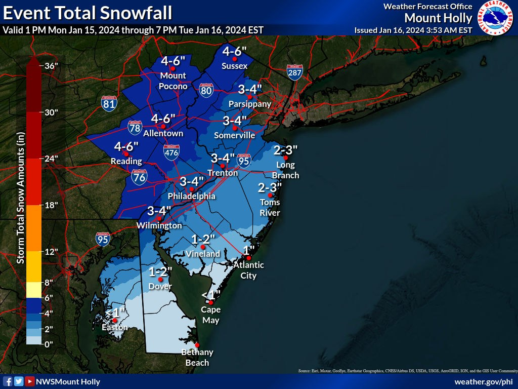
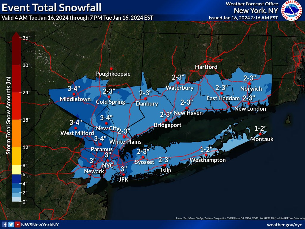
The NWS cut back on snowfall a bit for the 95 corridor from Philly to NYC, down to 3-4" and SE of 95 to 2-3", as per the maps. Not a surprise with a bit less snow falling overnight vs. the forecast and with a mix (and maybe plain rain) probably occurring SE of 95 by 7-9 am and a mix by 9-11 am for 95.
When any changeover to non-snow occurs will be critical in whether the 95 corridor gets to 3-4", as we're going to need to get a few hours of at least moderate snowfall to get there after the coastal starts to crank by 6-7 am, according to the discussion. Pretty sure most of the area SE of 95 already has their 2-3" or will by 6-7 am, based on posts I've seen on the weather boards.
Think 3" is very possible for Hillsborough and most of the 95 corridor. We'll see soon...Can't see Hillsborough getting 3 to 4.
Just walked Sweets and we have about 1 inch on the roadsThink 3" is very possible for Hillsborough and most of the 95 corridor. We'll see soon...
Hamilton got off to an early start, but the snowflakes stayed tiny and light to moderate. Woke up expecting more. Underperformed here.
Freehold around 2/3 inches
Debating to shovel now or around 345, hoping the rain washes most this away, but not wanting the ice / sleet to make it heavier
Debating to shovel now or around 345, hoping the rain washes most this away, but not wanting the ice / sleet to make it heavier
Bust..obviously not for your area but for those to north given the 3-6 forecast
About 1.5 here with wintry type mist
Looks like one more slug on precip to get through
Underperformer given they kept bumping totals from what should have been 1-3 call
Looks like one more slug on precip to get through
Underperformer given they kept bumping totals from what should have been 1-3 call
206 Hillsboro to Somerville and Belle Mead cleared. Township rds mostly clean. Just salting.no need to plow main rds. Got done with commercial lots and light fluffy 1.5 inch
AhhhBust..obviously not for your area but for those to north given the 3-6 forecast
Wondering if I should shovel now or wait until the rain melts everything?
Less than 2" here in Bergen County...my SIL said commute to Valley Hospital was similar to above...main roads good...side roads not.
Just had our best 30 min of the storm and as of 7 am, we're at 2.0". Starting to doubt we get to 3" here (my prediction was 3.2"), as the radar has been much spottier over the last several hours than forecasted and the short term models right now aren't showing more than another inch falling along/SE of 95, if that, especially if mixing reaches 95 later this morning when precip rates are expected to increase, at least for areas NW of 95 and N of 78, where the storm has underperformed significantly with only about 1-2" for much of NWNJ/NEPA/NENJ/NYC. Huge arguments right now over whether the coastal is going to deliver as much snow/precip as was modeled even a few hours ago.
And parts of CNJ have done well, but mostly SE of 95, where 2-3" have fallen (3.5" reported in South River, 2.5" in Howell and 2.5" as far south as Toms River), but the western parts of CNJ haven't done as well. It's not a bust yet, since the storm isn't over, but it'll be a bust if areas along 95 don't get at least another inch and if areas NW of 95 don't get at least 2 more inches - I'm not betting on that right now, but we'll see. Also, the mix line looks like it's along 195 now, but it's not clear how far NW that line goes (probably at least to 95). The storm was forecast very well for SNJ (south of 195) with 2-3" all over that area. Also Philly broke their snow futility streak with 1.5" as of 90 minutes ago, so they should've reached 2" by now, but not sure they'll get another inch.
Despite the storm underperforming, so far, for many, especially along/NW of 95, untreated roads are still snow covered and slippery and the treated roads are slushy, although they'll improve with traffic if we don't get much more snow. And NYC finally reported an end to their streak, as they have 1.4" as of 7 am.
Even if we get rain (not a given temps go above 32F along/NW of 95 - they likely will SE of 95 and definitely will near/along the coast), it's not going to melt anything with temps in the low 30s - that rain will simply be absorbed into the snow and freeze solid if you don't shovel it before sunset. The flip side is that if there's appreciable freezing rain, you might want to wait until that's over before shoveling as it wouldn't be great to shovel, exposing cold surfaces to the freezing rain and then having a glaze on your driveway/sidewalk. Personally, I'm waiting until about noon for that reason, but I have that luxury.Ahhh
Wondering if I should shovel now or wait until the rain melts everything?
Edit - just saw you said you're in Freehold and you likely won't get much freezing rain, so shoveling now should be fine. And with ~2.5", as I said, any rain you get won't melt the snow - it'll just make it wetter/slushier. Whatever you do, don't wait until after sunset, as it's likely not going to get above 32F again until Monday.
Last edited:
The HRRR did predict the spottier precip late last night and it's now predicting the sleet line hits 95 between 8-9 am and then has 95 going to freezing rain by 10-11 am with 0.1-0.2" of forecast freezing rain through 1-2 pm with precip ending then for the 95 corridor in NJ (will be earlier SW of Trenton and later NE of NYC). I'd rather not see that much freezing rain.
What about NW of 95 in North Jersey? Freezing rain to worry about? Debating whether to shovel now or do what you are and wait til laterThe HRRR did predict the spottier precip late last night and it's now predicting the sleet line hits 95 between 8-9 am and then has 95 going to freezing rain by 10-11 am with 0.1-0.2" of forecast freezing rain through 1-2 pm with precip ending then for the 95 corridor in NJ (will be earlier SW of Trenton and later NE of NYC). I'd rather not see that much freezing rain.
Depends where. Anywhere NW of 287 between 78 and 80 and anywhere N of 287 towards NY and the Tappan Zee, will not have any mixing, so shovel now would be fine. Between there and 95, the closer you get to 95, the more likely to see some freezing rain.What about NW of 95 in North Jersey? Freezing rain to worry about? Debating whether to shovel now or do what you are and wait til later
Going to guess I got 2-3" but hard to tell because it's raining.
Not that I mind a day off, but I remember standing for the bus in storms way worse than this. Pansy state of mind.
As of 8 am we're up to 2.2" and still snowing at 26F, so temps are on the increase as the mix line gets closer (looks to be 15-20 miles SE of me). Looks like another decent band is to our SW from Philly to Princeton and will hopefully hit us (as snow) - if it does, that could get us close to 3".
The forecast was pretty good, although hard to miss if you have that wide of a range...Sounds like i nailed this storm
1-4 covers everything
Take your meds
Snow measuring guidelines say to measure when there's a precip type change, so get out there with your ruler and report back, stat!Going to guess I got 2-3" but hard to tell because it's raining.
I mean some people got 1 and sounds like some people will get 3-4?The forecast was pretty good, although hard to miss if you have that wide of a range...
Appreciate your posts on here though, I always come here before I go to weather.gov.
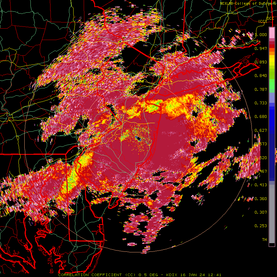
Of course that band is sleet, damn - best looking band of the storm lost to sleet. The dual pol looked like it and verified. Final (I think) snow measurement as of 8:30 am was 2.3" and I cleared the board to measure the sleet (which does get added to the snow, although sleet is much more dense than snow - typically 1" of liquid translates to 3" of sleet and 10" of snow). Hopefully the freezing rain holds off for awhile, although the temp has jumped up to 28F...As of 8 am we're up to 2.2" and still snowing at 26F, so temps are on the increase as the mix line gets closer (looks to be 15-20 miles SE of me). Looks like another decent band is to our SW from Philly to Princeton and will hopefully hit us (as snow) - if it does, that could get us close to 3".
Is it better to clear the driveway now or later?
Depends if you have salt to melt any freezing rain that falls
Snow pack getting more dense here but its very light freezing rain so we arent talking about huge ice accrual
no salt...so just wait til its over?Depends if you have salt to melt any freezing rain that falls
Snow pack getting more dense here but its very light freezing rain so we arent talking about huge ice accrual
Similar threads
- Replies
- 412
- Views
- 22K
ADVERTISEMENT
ADVERTISEMENT