
Colleges
- American Athletic
- Atlantic Coast
- Big 12
- Big East
- Big Ten
- Colonial
- Conference USA
- Independents (FBS)
- Junior College
- Mountain West
- Northeast
- Pac-12
- Patriot League
- Pioneer League
- Southeastern
- Sun Belt
- Army
- Charlotte
- East Carolina
- Florida Atlantic
- Memphis
- Navy
- North Texas
- Rice
- South Florida
- Temple
- Tulane
- Tulsa
- UAB
- UTSA
- Boston College
- California
- Clemson
- Duke
- Florida State
- Georgia Tech
- Louisville
- Miami (FL)
- North Carolina
- North Carolina State
- Pittsburgh
- Southern Methodist
- Stanford
- Syracuse
- Virginia
- Virginia Tech
- Wake Forest
- Arizona
- Arizona State
- Baylor
- Brigham Young
- Cincinnati
- Colorado
- Houston
- Iowa State
- Kansas
- Kansas State
- Oklahoma State
- TCU
- Texas Tech
- UCF
- Utah
- West Virginia
- Illinois
- Indiana
- Iowa
- Maryland
- Michigan
- Michigan State
- Minnesota
- Nebraska
- Northwestern
- Ohio State
- Oregon
- Penn State
- Purdue
- Rutgers
- UCLA
- USC
- Washington
- Wisconsin
High Schools
- Illinois HS Sports
- Indiana HS Sports
- Iowa HS Sports
- Kansas HS Sports
- Michigan HS Sports
- Minnesota HS Sports
- Missouri HS Sports
- Nebraska HS Sports
- Oklahoma HS Sports
- Texas HS Hoops
- Texas HS Sports
- Wisconsin HS Sports
- Cincinnati HS Sports
- Delaware
- Maryland HS Sports
- New Jersey HS Hoops
- New Jersey HS Sports
- NYC HS Hoops
- Ohio HS Sports
- Pennsylvania HS Sports
- Virginia HS Sports
- West Virginia HS Sports
ADVERTISEMENT
You are using an out of date browser. It may not display this or other websites correctly.
You should upgrade or use an alternative browser.
You should upgrade or use an alternative browser.
OT: Snow? - January 15-16?
- Thread starter Tango Two
- Start date
Eyeing it, looks like an inch or so in Jersey City. Starting to hear the precipitation hit the windows which means it must be mixing with sleet now.
Assuming you're in a mix area, here's what I kind of posted earlier, but summarized better (just posted elsewhere)...Is it better to clear the driveway now or later?
In the Edison area, we expect sleet for the next hour or so and then probably freezing rain for an hour or two until the precip is over in the early afternoon.
Two pieces of advice. If you have the option, waiting to shovel until the end of the precip is probably best, since if one shovels now it could lead to a glaze from freezing rain falling on freshly shoveled driveways and sidewalks. Personally, I'm going to wait until after about 1 pm to shovel to avoid this risk, since freezing rain falling on fairly dry snow will just make the snow wetter (and we won't get anywhere near enough freezing rain to melt the snow).
Second thing is that people should absolutely shovel by about 5-6 pm at the latest, since temps, which will eventually get to about 32-33F in town in the afternoon, will be below 32F by sunset and will drop quickly after that (will be down to 25F by 8 pm), freezing solid the wet, slushy snow on paved surfaces - and it may not get above 32F until Monday.

Bac - Is this it? It's a glorified dusting. Serious underperformance. Just another swing and miss forecast!Depends if you have salt to melt any freezing rain that falls
Snow pack getting more dense here but its very light freezing rain so we arent talking about huge ice accrual
Last edited:
Bac - Is this it? It's a glorified dusting. Serious underperformance.
Yup no big deal in our area..did schools end up closing
But definitely icing on non treated cleared surfaces
Yes, schools closed probably due to timing and possible icy conditions. As for the snow, perhaps not a full bust, but I give the ranking of:Yup no big deal in our area..did schools end up closing
But definitely icing on non treated cleared surfaces
HALF BUST

Well, we flipped to freezing rain a little while ago, but it did sleet pretty decently for 30-45 minutes, which put down 0.1" of sleet before the ZR, so our final total for the storm is 2.4", which is a bit of a bust vs. the NWS advisory for 3-5" and my prediction of 3.2", but still a nice storm if you like snow and it'll be around to enjoy for at least a week and might even be topped off on Friday. I recall being excited, but a bit skeptical when the NWS bumped up their forecast yesterday afternoon; in hindsight their 2-4" forecast for 95 and most of CNJ/NNJ would've been better.Of course that band is sleet, damn - best looking band of the storm lost to sleet. The dual pol looked like it and verified. Final (I think) snow measurement as of 8:30 am was 2.3" and I cleared the board to measure the sleet (which does get added to the snow, although sleet is much more dense than snow - typically 1" of liquid translates to 3" of sleet and 10" of snow). Hopefully the freezing rain holds off for awhile, although the temp has jumped up to 28F...
I cleared a small paved area when it changed to sleet and yes, it's now covered with the 0.1" of sleet and a glaze of ice on top, which will likely get worse for untreated paved surfaces, as temps are still only 29F and freezing rain continues to fall until early afternoon here with temps only forecast to reach 32F. Time for some sleep, then some shoveling...
The story is less about snow and more a case of watch out for ice due to freezing rain and then hard freeze tonight.
Agree. According to the hi-res models we reach our high temp in about 2 hours, and then we start sliding down. THere will be plenty of moisture on the roads still.The story is less about snow and more a case of watch out for ice due to freezing rain and then hard freeze tonight.
Agree. According to the hi-res models we reach our high temp in about 2 hours, and then we start sliding down. THere will be plenty of moisture on the roads still.
Yep...going to be very dangerous on side roads tonight
Less than 1 inch on the Wall Brick border, with rain washing snow away off paved surfaces. Mostly gone now on roads/pavement.Can't see Hillsborough getting 3 to 4.
...Pennsylvania...
...Berks County...
District Twp 1.8 in 0445 AM 01/16 Trained Spotter
...Bucks County...
Bensalem 1.7 in 1150 PM 01/15 Trained Spotter
New Hope 1.5 in 0622 AM 01/16 Public
Furlong 1.2 in 1250 AM 01/16 Trained Spotter
Hilltown Twp 1.1 in 0100 AM 01/16 Trained Spotter
...Chester County...
West Bradford Twp 1.9 in 1146 PM 01/15 Trained Spotter
East Coventry Twp 1.2 in 1135 PM 01/15 Public
...Delaware County...
Boothwyn 3.4 in 0505 AM 01/16 Trained Spotter
Chadds Ford Twp 2.2 in 1200 AM 01/16 Trained Spotter
Morton 2.0 in 1200 AM 01/16 Trained Spotter
...Lehigh County...
Macungie 2.0 in 0600 AM 01/16 Trained Spotter
...Montgomery County...
New Hanover Twp 2.7 in 0615 AM 01/16 Trained Spotter
King of Prussia 2.5 in 0614 AM 01/16 Trained Spotter
Norristown 2.1 in 1144 PM 01/15 Trained Spotter
Eagleville 2.1 in 0615 AM 01/16 Trained Spotter
...Northampton County...
Hellertown 1.7 in 0555 AM 01/16 Trained Spotter
North Catasauqua 1.4 in 0600 AM 01/16 Public
...Philadelphia County...
Philadelphia International A 1.5 in 1218 AM 01/16 Public
Last edited:
New York City
- Central Park in Manhattan: 1.4 inches
- Midwood in Brooklyn: 1.7 inches
- Whitestone in Queens: 2.2 inches
- Howard Beach in Queens: 2 inches
- Little Neck in Queens: 1.8 inches
- JFK Airport in Queens: 1.7 inches
- LaGuardia Airport in Queens: 1.6 inches
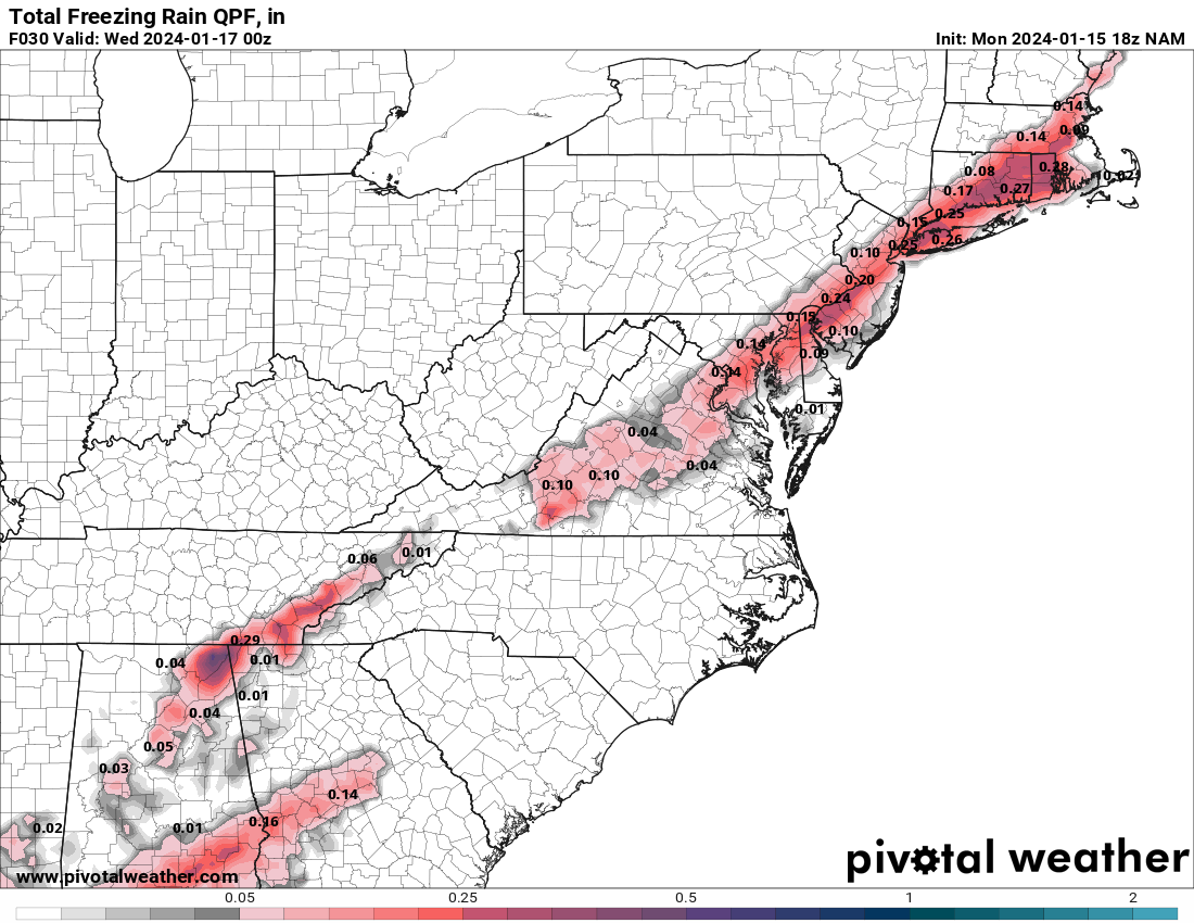
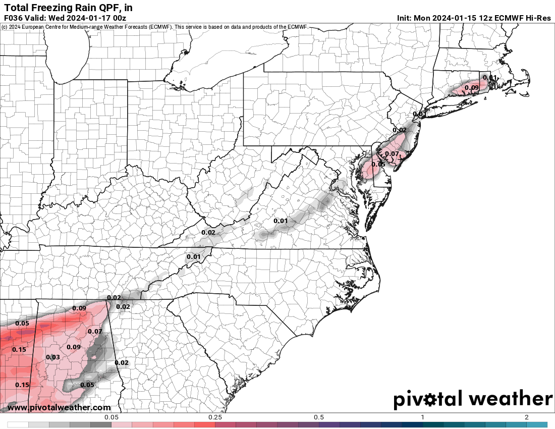
Score a huge win for the NAM and the RGEM the two major mesoscale/regional models, as both models have been calling for significant freezing rain (ZR) since Sunday morning and generally weren't joined by the global models in predicting appreciable ZR until Monday morning or afternoon.NAM and RGEM have consistently shown that freezing rain risk after about 9 am or so, but the globals either have all snow for 95 or a later changover to sleet or freezing rain. Agree we don't want freezing rain, as it's dangerous and aesthetically unpleasing. Saving grace could be that it'll mostly be falling on top of snow, forming a crust and not falling on bare ground forming ice rinks. Here's the difference between the NAM and Euro on freezing rain (ZR), which is substantial. If the NAM verified, that's 1-2" of snowfall lost to ZR and a risk of serious icing. Let's hope it's wrong.
Hooray, they did it!New York City
- Central Park in Manhattan: 1.4 inches
- Midwood in Brooklyn: 1.7 inches
- Whitestone in Queens: 2.2 inches
- Howard Beach in Queens: 2 inches
- Little Neck in Queens: 1.8 inches
- JFK Airport in Queens: 1.7 inches
- LaGuardia Airport in Queens: 1.6 inches
...Bergen County...
Oakland 1.5 in 0800 AM 01/16 COCORAHS
Montvale 1.8 ESE 1.2 in 0800 AM 01/16 COCORAHS
Fair Lawn 1.1 in 0717 AM 01/16 COCORAHS
Tenafly 1.1 in 0730 AM 01/16 COCORAHS
...Essex County...
Montclair 1.2 in 0800 AM 01/16 COCORAHS
...Hudson County...
Jersey City 1.5 in 0845 AM 01/16 Public
Harrison 1.0 in 0700 AM 01/16 COCORAHS
...Passaic County...
West Milford 1.7 in 0700 AM 01/16 COCORAHS
Hawthorne 1.4 in 0700 AM 01/16 COCORAHS
Little Falls 1.3 in 0700 AM 01/16 COCORAHS
Wayne 1.2 in 0700 AM 01/16 COCORAHS
...Union County...
Clark 1.7 in 0739 AM 01/16 COCORAHS
Newark Airport 1.7 in 0700 AM 01/16 Official NWS Obs
New Providence 1.1 in 0730 AM 01/16 COCORAHS
Westfield 1.0 in 0745 AM 01/16 COCORAHS
Westfield 0.8 WSW 1.0 in 0700 AM 01/16 COCORAHS
except they were off big time on snow amounts as they called for 3-5 inches so dont give them too much applauseScore a huge win for the NAM and the RGEM the two major mesoscale/regional models, as both models have been calling for significant freezing rain (ZR) since Sunday morning and generally weren't joined by the global models in predicting appreciable ZR until Monday morning or afternoon.
they did get the freezing rain aspect correctly but why were the mets so dismissive of freezing rain potential, its not like these situations have not been uncommon the last 20 years.
better updated totals with tons of locations
...New Jersey...
...Atlantic County...
4 SSW Folsom 2.0 in 0700 AM 01/16 Cocorahs
Estell Manor 1.4 in 0800 AM 01/16 CO-OP Observer
Atlantic City International 1.3 in 0700 AM 01/16 ASOS
1 S Galloway Twp 1.3 in 0700 AM 01/16 Cocorahs
Somers Point 0.2 NW 1.1 in 0620 AM 01/16 COCORAHS
...Burlington County...
1 W Riverside 3.5 in 0952 AM 01/16 Public
Columbus 3.0 in 0600 AM 01/16 Trained Spotter
Moorestown 3.0 in 0500 AM 01/16 Public
Mount Laurel 3.0 in 0500 AM 01/16 Trained Spotter
Mount Holly WFO 2.9 in 0654 AM 01/16 Official NWS Obs
1 NNE Rancocas 2.9 in 0730 AM 01/16 NWS Employee
Willingboro Twp 1.3 ESE 2.9 in 0700 AM 01/16 COCORAHS
2 NW South Jersey Regional A 2.6 in 0640 AM 01/16 NWS Employee
1 NE Marlton 2.5 in 0830 AM 01/16 Public
1 W Medford Lakes 2.5 in 0800 AM 01/16 Cocorahs
Lake Pine 1.0 in 0935 PM 01/15 Trained Spotter
...Camden County...
Greentree 3.5 in 0501 AM 01/16 NWS Employee
Pennsauken 1 N 2.8 in 0700 AM 01/16 COOP
1 NNW Lawnside 2.6 in 0645 AM 01/16 Cocorahs
Haddon Township 2.6 in 0600 AM 01/16 Trained Spotter
Mount Ephraim 2.5 in 0810 AM 01/16 COCORAHS
1 S Magnolia 2.4 in 0700 AM 01/16 CO-OP Observer
Haddon Heights 2.3 in 0845 AM 01/16 Public
Winslow Twp. 3.5 W 2.1 in 0715 AM 01/16 COCORAHS
...Cape May County...
Dennisville 1.0 in 1039 PM 01/15 Trained Spotter
Ocean City 1.6 SW 0.8 in 0700 AM 01/16 COCORAHS
Woodbine 0.8 NNW 0.7 in 0700 AM 01/16 COCORAHS
Ocean View 0.6 in 0625 AM 01/16 Trained Spotter
Cape May Court House 0.5 in 0700 AM 01/16 Trained Spotter
...Cumberland County...
Upper Deerfield Twp 0.7 NNE 2.4 in 0615 AM 01/16 COCORAHS
...Gloucester County...
Mantua 3.0 in 0530 AM 01/16 Public
Paulsboro 0.4 N 3.0 in 0800 AM 01/16 COCORAHS
1 SSE Mullica Hill 2.9 in 0215 AM 01/16 Public
2 W Glassboro 2.5 in 0700 AM 01/16 Cocorahs
Washington Twp 2.1 NNW 2.1 in 0700 AM 01/16 COCORAHS
Pitman 2.0 in 0645 AM 01/16 Trained Spotter
2 SSE Monroe Twp 1.9 in 0700 AM 01/16 Cocorahs
West Deptford Twp 1.0 in 0935 PM 01/15 Trained Spotter
...Hunterdon County...
Quakertown 2.7 in 0700 AM 01/16 Cocorahs
1 N Califon 2.1 in 0830 AM 01/16 Cocorahs
2 W High Bridge 2.1 in 0830 AM 01/16 Cocorahs
1 SE Bethlehem Twp 2.0 in 0715 AM 01/16 Cocorahs
1 W McPherson 2.0 in 0700 AM 01/16 Cocorahs
3 NNW Bartles Corners 2.0 in 0700 AM 01/16 CO-OP Observer
2 WSW Swinesburg 1.8 in 0550 AM 01/16 Cocorahs
Clinton Twp. 4 N 1.7 in 0830 AM 01/16 COCORAHS
Frenchtown 1.7 in 0700 AM 01/16 Cocorahs
Readington Twp 1.8 ENE 1.6 in 0700 AM 01/16 COCORAHS
Flemington 2.3 E 1.2 in 0800 AM 01/16 COCORAHS
...Mercer County...
Princeton 2.3 E 2.5 in 0700 AM 01/16 COCORAHS
1.9 NE Windsor 2.4 in 0700 AM 01/16 COOP
Hamilton Square 2.3 in 0700 AM 01/16 Cocorahs
Robbinsville Twp. 2.2 in 0730 AM 01/16 Public
Trenton Mercer Airport 2.2 in 0700 AM 01/16 ASOS
1 SW Hopewell 2.0 in 0700 AM 01/16 Cocorahs
Pennington 1.7 SE 2.0 in 0630 AM 01/16 COCORAHS
Woodsville 2.0 in 0800 AM 01/16 Trained Spotter
Princeton 1.8 in 0609 AM 01/16 Trained Spotter
West Windsor Twp 2.6 N 1.7 in 0403 AM 01/16 COCORAHS
2 ESE Washington Crossing 1.1 in 1159 PM 01/15 Cocorahs
...Middlesex County...
South River 3.5 in 0535 AM 01/16 Trained Spotter
Old Bridge 3.0 in 0945 AM 01/16 Trained Spotter
Cheesequake 2.8 in 0800 AM 01/16 Public
1 S Jamesburg 2.8 in 0945 AM 01/16 Trained Spotter
New Brunswick 3 SE 2.5 in 0800 AM 01/16 COOP
North Brunswick Twp 1.5 W 1.9 in 0700 AM 01/16 COCORAHS
2 SE Milltown 1.8 in 0700 AM 01/16 Cocorahs
Edison 1.6 in 0800 AM 01/16 Broadcast Media
1 SSW Green Brook Twp 1.2 in 0800 AM 01/16 Cocorahs
Woodbridge Twp. 1 NNE 1.2 in 0600 AM 01/16 COCORAHS
...Monmouth County...
Wall Twp 3.4 in 0645 AM 01/16 Public
1 NNW Neptune City 3.3 in 0620 AM 01/16 Public
1 SSW Howell 3.0 in 0700 AM 01/16 Public
Long Branch 3.0 in 0630 AM 01/16 CO-OP Observer
1 SSW Freehold 2.9 in 0705 AM 01/16 Trained Spotter
1 NNW Holmdel 2.8 in 0630 AM 01/16 Trained Spotter
Union Beach 2.1 SSE 2.8 in 0630 AM 01/16 COCORAHS
Freehold 2.6 in 0730 AM 01/16 Public
Freehold Twp 2.5 in 0750 AM 01/16 Trained Spotter
Ocean Twp 0.8 SE 2.5 in 0700 AM 01/16 COCORAHS
Upper Freehold Twp. 2.3 S 2.5 in 0830 AM 01/16 COCORAHS
Cream Ridge 2.3 in 0730 AM 01/16 Trained Spotter
...Morris County...
Long Valley 2.0 in 0725 AM 01/16 Trained Spotter
Rockaway 2.0 in 0800 AM 01/16 COCORAHS
1 SSW Wharton 2.0 in 0700 AM 01/16 Cocorahs
2 S Kinnelon 1.8 in 0845 AM 01/16 Cocorahs
1 SW Netcong 1.8 in 0730 AM 01/16 Trained Spotter
2 ESE Milton 1.7 in 0800 AM 01/16 Cocorahs
Lake Hopatcong 1.6 in 0702 AM 01/16 Trained Spotter
1 S Ironia 1.5 in 0700 AM 01/16 Cocorahs
Millington 1.5 in 0852 AM 01/16 Cocorahs
1 WSW Morristown 1.5 in 0845 AM 01/16 Cocorahs
Randolph Twp. 2 E 1.5 in 0800 AM 01/16 COCORAHS
Butler 1.4 in 0800 AM 01/16 Cocorahs
1 SW Mountain Lakes 1.3 in 0700 AM 01/16 Cocorahs
1 NNE Chatham 1.1 in 0700 AM 01/16 Cocorahs
1 ENE Mendham 1.0 in 0645 AM 01/16 Trained Spotter
1 SW Madison 1.0 in 0700 AM 01/16 Cocorahs
Pompton Plains 1.0 in 0900 AM 01/16 Public
...Ocean County...
2 ESE Ramtown 2.8 in 0730 AM 01/16 Public
Whiting 2.8 in 0750 AM 01/16 Public
Toms River Twp 3.6 WSW 2.7 in 0800 AM 01/16 COCORAHS
Beachwood 2.6 in 0730 AM 01/16 Cocorahs
Lakehurst 2.5 in 0630 AM 01/16 Cocorahs
1 NNW Lanoka Harbor 2.5 in 0700 AM 01/16 Cocorahs
Pine Beach 0.4 NW 2.5 in 0630 AM 01/16 COCORAHS
Point Pleasant Beach 2.5 in 0700 AM 01/16 COCORAHS
2 SSW Jackson 1.8 in 0700 AM 01/16 Trained Spotter
...Salem County...
Pittsgrove Twp 1.9 NNE 2.4 in 0725 AM 01/16 COCORAHS
2 ESE Rosenhayn 2.0 in 0828 AM 01/16 Cocorahs
Woodstown 1.0 in 0700 AM 01/16 COCORAHS
...Somerset County...
Millstone 3 S 3.0 in 0500 AM 01/16 COOP
3 N Bridgewater 2.5 in 0700 AM 01/16 Trained Spotter
Franklin Twp. 2.7 NE 1.7 in 0700 AM 01/16 COCORAHS
1 E Middlebush 1.7 in 0900 AM 01/16 Cocorahs
2 NNE Branchburg Twp 1.5 in 0800 AM 01/16 Cocorahs
Neshanic Station 1.5 in 0845 AM 01/16 Public
Watchung 1.4 WNW 1.5 in 0700 AM 01/16 COCORAHS
Bernards Twp 0.9 ENE 1.4 in 0700 AM 01/16 COCORAHS
1 SW Manville 1.3 in 0600 AM 01/16 Cocorahs
Peapack-Gladstone 1.2 NW 1.2 in 0735 AM 01/16 COCORAHS
...Sussex County...
1 WNW Andover-Aeroflex Airpo 2.0 in 0845 AM 01/16 Cocorahs
Sparta 2.0 in 0815 AM 01/16 Emergency Mngr
1 ESE Montague 1.4 in 0700 AM 01/16 Cocorahs
2 WNW Vernon 1.0 in 0911 AM 01/16 Trained Spotter
...Warren County...
Belvidere 2.1 in 0700 AM 01/16 CO-OP Observer
1 SSW Marksboro 2.0 in 0700 AM 01/16 Cocorahs
1 NW Stewartsville 2.0 in 0900 AM 01/16 Trained Spotter
Greenwich Twp 1.6 S 1.7 in 0700 AM 01/16 COCORAHS
1 W Hackettstown 1.5 in 0703 AM 01/16 Trained Spotter
Washington Twp 2.4 ESE 1.5 in 0700 AM 01/16 COCORAHS
May have to upgrade this storm to 3/4 bust. Weak numbers....Bergen County...
Oakland 1.5 in 0800 AM 01/16 COCORAHS
Montvale 1.8 ESE 1.2 in 0800 AM 01/16 COCORAHS
Fair Lawn 1.1 in 0717 AM 01/16 COCORAHS
Tenafly 1.1 in 0730 AM 01/16 COCORAHS
...Essex County...
Montclair 1.2 in 0800 AM 01/16 COCORAHS
...Hudson County...
Jersey City 1.5 in 0845 AM 01/16 Public
Harrison 1.0 in 0700 AM 01/16 COCORAHS
...Passaic County...
West Milford 1.7 in 0700 AM 01/16 COCORAHS
Hawthorne 1.4 in 0700 AM 01/16 COCORAHS
Little Falls 1.3 in 0700 AM 01/16 COCORAHS
Wayne 1.2 in 0700 AM 01/16 COCORAHS
...Union County...
Clark 1.7 in 0739 AM 01/16 COCORAHS
Newark Airport 1.7 in 0700 AM 01/16 Official NWS Obs
New Providence 1.1 in 0730 AM 01/16 COCORAHS
Westfield 1.0 in 0745 AM 01/16 COCORAHS
Westfield 0.8 WSW 1.0 in 0700 AM 01/16 COCORAHS
looks like the shore areas jackpotted in NJ...monmouth and southern middlesex and ocean
reports say you got 3Less than 1 inch on the Wall Brick border, with rain washing snow away off paved surfaces. Mostly gone now on roads/pavement.
Might need to recalibrate that ruler with 3" or more reported near you...Less than 1 inch on the Wall Brick border, with rain washing snow away off paved surfaces. Mostly gone now on roads/pavement.
I just saw in the Asbury Park Press Wall got 3.4. Think the first 2 inches of that ruler were snapped off. 🤷♂️reports say you got 3
"Top totals in Monmouth County were in the two to four inch range, with the highest being 3.4 inches in Wall, 3 inches in Howell and 2.9 inches in Freehold, according to the National Weather Service. Ocean County saw between one to three inches, with 3 inches in Lanoka Harbour, and 2.5 inches in Brick being the highest reports as of Tuesday morning."
My rain gauge says 1/2" . 😜Might need to recalibrate that ruler with 3" or more reported near you...
I did not stay up all night measuring the snow at the height before it changed to rain, but perhaps? Glad most of it is washing away with the steady rain.
Well, can't get it all right, but they did nail the freezing rain for days, which is impressive. It also seems like in many storms the NWS and many others discount the models showing changeovers to sleet, freezing rain and rain and I'm not sure why.except they were off big time on snow amounts as they called for 3-5 inches so dont give them too much applause
they did get the freezing rain aspect correctly but why were the mets so dismissive of freezing rain potential, its not like these situations have not been uncommon the last 20 years.
Yeah, if you don't measure soon after a changeover, especially to liquid precip, the snow will compact very quickly, which is what I assume happened in your case.I just saw in the Asbury Park Press Wall got 3.4. Think the first 2 inches of that ruler were snapped off. 🤷♂️
"Top totals in Monmouth County were in the two to four inch range, with the highest being 3.4 inches in Wall, 3 inches in Howell and 2.9 inches in Freehold, according to the National Weather Service. Ocean County saw between one to three inches, with 3 inches in Lanoka Harbour, and 2.5 inches in Brick being the highest reports as of Tuesday morning."
My rain gauge says 1/2" . 😜
I did not stay up all night measuring the snow at the height before it changed to rain, but perhaps? Glad most of it is washing away with the steady rain.
careful though because that 3.4 amounts was taken from the PUBLIC, not a trained spotterYeah, if you don't measure soon after a changeover, especially to liquid precip, the snow will compact very quickly, which is what I assume happened in your case.
To be fair, we’re talking about a trace to 0.05” of ice accretion (not including sleet). There was always the chance of a sleet and minor ZR mix. The NAM was showing over 0.30” of ice last night for 95 corridor which is still a bogus solution as that would be a catastrophic outcome (and something our area almost never sees due to proximity to the ocean).except they were off big time on snow amounts as they called for 3-5 inches so dont give them too much applause
they did get the freezing rain aspect correctly but why were the mets so dismissive of freezing rain potential, its not like these situations have not been uncommon the last 20 years.
Here in Southern Hunterdon we have 1.25” on the ground and a very slight sleet zr crust on top. Light sleet at the moment.
Where exactly are you? I manage Unionville Vineyards and am venturing over there in a couple hours unless the back roads are iced up.To be fair, we’re talking about a trace to 0.05” of ice accretion (not including sleet). There was always the chance of a sleet and minor ZR mix. The NAM was showing over 0.30” of ice last night for 95 corridor which is still a bogus solution as that would be a catastrophic outcome (and something our area almost never sees due to proximity to the ocean).
Here in Southern Hunterdon we have 1.25” on the ground and a very slight sleet zr crust on top. Light sleet at the moment.
Ringoes, took dog for a walk an hour ago and traversed a county and side roads and all were down to slush. But take every precaution you need, temps are in 20s.Where exactly are you? I manage Unionville Vineyards and am venturing over there in a couple hours unless the back roads are iced up.
Also in Southern Hunterdon and I'd say we got 1.5-2 at most. Storm last week was certainly more. Drove for a few minutes and main roads were fine and even my street was but that a couple of hours ago.
Some nice restaurant news for Flemington today as well.
Some nice restaurant news for Flemington today as well.
I made a big mistake by shoveling earlier. 28 degrees here and frozen rain now. I figured it would be all snow today...even my weather app says it snowing but it's wrong. I threw down some salt since it's slippery now.
Seems to me they’ve screw up the duration of the precipitation the last couple mixed precipitation storms.Yeah, if you don't measure soon after a changeover, especially to liquid precip, the snow will compact very quickly, which is what I assume happened in your case.
This crap is going to continue late into the afternoon now.
Union Hotel project?Also in Southern Hunterdon and I'd say we got 1.5-2 at most. Storm last week was certainly more. Drove for a few minutes and main roads were fine and even my street was but that a couple of hours ago.
Some nice restaurant news for Flemington today as well.
Yeah David Burke is overseeing 3 different concepts that will share 1 liquor license. At least there will finally be somewhere to get a glass of wine downtown. That said, viva la rooster!Union Hotel project?
Sucks...we've been talking about not shoveling for the last day or so, given that risk; I'll be shoveling in the next 2 hours or so as it's just about over for me with models showing <0.1" of precip left to fall and we're likely to have the freezing rain change back to sleet and then snow before ending around 4 pm. Temp up to 30F, but not forecast to go above 32F (just up to 31F). Of course, shoveling then salting will likely prevent icing, but not everyone has salt.I made a big mistake by shoveling earlier. 28 degrees here and frozen rain now. I figured it would be all snow today...even my weather app says it snowing but it's wrong. I threw down some salt since it's slippery now.
Similar threads
- Replies
- 412
- Views
- 22K
ADVERTISEMENT
ADVERTISEMENT