Continued model support for the shift SW with the track after landfall or near landfall in NC...


Follow along with the video below to see how to install our site as a web app on your home screen.
Note: This feature may not be available in some browsers.
The 11 pm NHC track is out and Florence is still a 140 mph Cat 4 storm, expected to strengthen to 155 mph over the next 24 hours and then weaken to 120-130 mph near landfall. The track is about the same up until landfall or very close to landfall, with a cat 3/4 hurricane (115-130 mph likely, making landfall or coming close to it somewhere between Wilmington and Morehead City, NC by about early Friday morning.
At that point, as we've been seeing and continue to see, the steering currents essentially disappear, as Florence becomes essentially engulfed from the west, east and north in that anomalously strong ridge that will be over the eastern 1/3 of the US into the western Atlantic.
The NHC track has thus been shifted significantly further to the SW from Friday morning through Sunday. Instead of going inland to Charlotte and then Asheville the 11 pm track goes to about Florence and then Greenville, SC, after landfall, over 2 days. The NHC did not completely buy the Euro/GFS move of Florence simply drifting slowly SW over 2 days from the NC coast to the SC coast near Charleston or Hilton Head and then going inland.
As I said earlier, this all makes evacuation planning very difficult, since people can't be sure what part of the coast will be hit and for how long and what part of inland areas will be drenched with 10-20" or more of rain. The only sure thing, I think, is that areas within 50-75 miles inland of the NC coast from near landfall (i.e., NW of about the SC/NC border to NW of Cape Hatteras), will surely have high winds and 10-20" rains with a slow moving storm near the coast. Beyond that, it's hard to know where the coastal and inland impacts will be.
FORECAST POSITIONS AND MAX WINDS
INIT 12/0300Z 28.4N 68.7W 120 KT 140 MPH
12H 12/1200Z 29.6N 70.8W 125 KT 145 MPH
24H 13/0000Z 31.4N 73.4W 135 KT 155 MPH
36H 13/1200Z 32.9N 75.5W 130 KT 150 MPH
48H 14/0000Z 33.8N 76.8W 115 KT 130 MPH
72H 15/0000Z 34.3N 78.2W 95 KT 110 MPH...INLAND
96H 16/0000Z 34.3N 79.7W 45 KT 50 MPH...INLAND
120H 17/0000Z 34.9N 82.5W 25 KT 30 MPH...INLAND


Flo is effin' nuts. Current view here is we likely stay in place today (in Pinehurst). Then head up and over to Boone early Thursday, or perhaps tonight, as needed. Stay in Boone a day or two until we see a predicted path, which, currently, has Flo heading up the Blue Ridge from SC towards Asheville and Boone. At that point we evacuate the second time toward south-central VA then head back down toward Raleigh and Phurst, and assess the effects.
It's just nuts. Unprecedented. You may actually be best to stay in Pinehurst, which could handle 3-6" of rain and some tropical storm force winds, although Boone will certainly be better for Thursday-Saturday and then if it looks like Boone is going to get 10+" of rain, head back to Pinehurst. Or adjust as needed if the forecast changes, which it certainly might. What a nightmare scenario for planning for millions of people.
Greenville, SC resident here. Based on this track, what can we expect?[/QUOTE
Based on the NHC track, 4-8" of rain late in the weekend with gusty winds (maybe 30-40 mph), but the error bars on the track past Friday are large, so it's possible you could have little to no impacts.

Florence remains a powerful storm, which will bring catastrophic surge, wind, and rainfall impacts to large parts of NC and SC, especially along the coast from Thursday night through Saturday or even Sunday. Track and impact uncertainties are quite large however, given the weak steering currents as the storm gets to the NC coast and then slows to a crawl, with models showing significant variations in the track, once it reaches landfall or near landfall.
These track uncertainties post-landfall/near-landfall in NC are an emergency management nightmare of epic proportions, as many people, especially inland, now can't really know where to evacuate from or where to evacuate to, outside of places far away like Atlanta or Asheville or Blacksburg or DC. This is harder than when a track is known - people can usually evacuate 100 miles away from a well known track and be fine. The only sure thing, I think, is that areas within 50-75 miles of the NC/SC coasts from near landfall (i.e., NW of about Myrtle Beach to NW of Cape Hatteras), will surely have high winds and 10-20" rains and major storm surges at/near the coast, with a slow moving storm near the coast. Beyond that, it's hard to know where the coastal and inland impacts will be.
The only good news is that Florence will have little or no impact north of about DC to Delaware and NE of there, including all of NJ/NY/PA, except for heavy surf, beach erosion and riptides for the next few days. There could be some rain in 5-7 days from the remnants, but that's very uncertain right now.
As of the 5 am NHC advisory, Florence has 130 mph winds, but is forecast to increase back up to 140-145 mph winds by tonight, but then weaken to 120-130 mph (cat 3) as it nears landfall near Wilmington, NC early Friday. The NHC track then moves Florence SW either along or just off the NC, then SC coasts just NE of Charleston from Friday through Sunday, as the storm slows to a crawl and weakens to a cat 1/2 storm; storm surge, wind damage and rainfall amounts of 10-20"+ could be catastrophic along this coastal path. The NHC track then has landfall NE of Charleston and then goes inland towards Greenville SC by Monday, bringing torrential, potentially catastrophic 10-20" rains along its entire path.
Last night's 00Z models (7 pm EST data inputs) all are pretty consistent with Florence making landfall or coming close to landfall along the NC coast in the Wilimington to Morehead City, NC area. After that, model divergence is quite large, due to the lack of steering currents after that.
- Specifically, the Euro has Florence almost making landfall near Wilmington, NC early Friday, then stalling, then slowly moving SW along the NC, then SC coasts (within ~50 miles of the coast, bringing high winds and storm surges and 10-20"+ rains) over the next 2 days, finally making landfall around Savannah, GA Sunday night, then going inland to Atlanta, then Knoxville, then Roanake, VA, then towards the coast and out to sea as a remnant low.
- The UK has the storm making landfall around Morehead City, NC, then moving inland to Charotte, then Greenville, SC, then WV over Friday to Sunday.
- The GFS looks very similar to the Euro, with a Cat 4 storm just about making landfall around Morehead City, NC early Friday, then slowly moving SW along the NC/SC coasts, eventually making landfall as a cat 1/2 storm around Charleston, SC on Sunday morning, then moving inland towards Greenville, SC, then Asheville, NC, then SW VA over Sunday to Tuesday, then dissipating.
- The CMC has landfall early Friday on the Outer Banks, then has Florence meandering just inland for 2-3 days before heading SW through central SC and GA by Monday.
So, hopefully these wildly different model outputs illustrate the high level of uncertainty around whether Florence makes a landfall and where and whether if weakens or not; whether Florence goes SW along, inland or just offshore from NC through SC and whether Florence goes to Charleston or Savannah; whether Florence goes inland from NC or NE SC or SW SC and then where Florence goes after going inland and how much rain does Florence bring on its inland path. And the various impacts of Florence are huge variables dependent on that uncertain path.
The NHC track is below and here are the forecast positions/winds:
FFORECAST POSITIONS AND MAX WINDS
INIT 12/0900Z 29.0N 70.1W 115 KT 130 MPH
12H 12/1800Z 30.3N 72.1W 120 KT 140 MPH
24H 13/0600Z 32.0N 74.4W 125 KT 145 MPH
36H 13/1800Z 33.2N 76.1W 120 KT 140 MPH
48H 14/0600Z 33.8N 77.3W 105 KT 120 MPH...NEAR THE COAST
72H 15/0600Z 33.8N 78.2W 85 KT 100 MPH...NEAR THE COAST
96H 16/0600Z 33.6N 79.7W 45 KT 50 MPH...INLAND
120H 17/0600Z 34.2N 82.7W 25 KT 30 MPH...INLAND
Model outputs at 00Z showing the general shift of the track to the SW after landfall/near landfall in NC...
And here's the WPC/NOAA official 7-day precipitation forecast that was just issued - this is based on the official NHC track and obviously could shift significantly, depending on when and where Florence goes inland, but clearly the threat of catastrophic rains/flooding is there.
The usual links, including a great blog entry from Wunderground last night outlining all the possibilities/impacts.
https://www.wunderground.com/.../Hurricane-Storm-Surge...
https://www.33andrain.com/.../1404-dangerous.../...
https://www.nhc.noaa.gov/graphics_at1.shtml?cone#contents
https://www.weather.gov/

I know there are a bunch of "live cams" for the NC/SC area you can watch......but, just sharing my personal favorite..... The "Frying Pan Tower".. which is a former US Coast Guard lighthouse located about 33 miles off NC coast.
This cam is actually great to watch any time (not just during storms)... tons of marine life all around... on many days you can see manta-rays, sea rays and sharks through the usually calm and clear waters......
Watching over the last few days.... the angry seas have defiantly started already...
Interestingly... it is (or recently was) some sort of "micro - hotel"... but, not sure that's really going on...
"frying pan" nickname comes from the large "fried egg" pattern of the helicopter landing pad....
https://en.wikipedia.org/wiki/Frying_Pan_Shoals_Light
https://www.cntraveler.com/story/why-the-frying-pan-tower-is-the-most-dangerous-hotel-in-the-world

frying pan" nickname comes from the large "fried egg" pattern of the helicopter landing pad....
US National Weather Service Philadelphia/Mount Holly
9 mins ·
Good afternoon! We've updated our briefing package with the latest information on Hurricane Florence and its potential effects on our area here: https://www.weather.gov/media/phi/current_briefing.pdf
You don't really have to post Mt. Holly's briefing packages for this storm - there are not substantive impacts and so reading it is a waste of time.
I respectfully disagree. I think a lot of people want to know whether there would be impacts on New Jersey, and at least this briefing package reassures them that the only effects will probably be on the beaches. Sometimes good news is as valuable as bad news, and this is one of those times.
Your "good news" is technically the absence of news.
As I said, no substantive impact. Ergo, no reason to parse the PowerPoint.
I respectfully disagree. I think a lot of people want to know whether there would be impacts on New Jersey, and at least this briefing package reassures them that the only effects will probably be on the beaches. Sometimes good news is as valuable as bad news, and this is one of those times.
I know there are a bunch of "live cams" for the NC/SC area you can watch......but, just sharing my personal favorite..... The "Frying Pan Tower".. which is a former US Coast Guard lighthouse located about 33 miles off NC coast.
This cam is actually great to watch any time (not just during storms)... tons of marine life all around... on many days you can see manta-rays, sea rays and sharks through the usually calm and clear waters......
Watching over the last few days.... the angry seas have defiantly started already...
Interestingly... it is (or recently was) some sort of "micro - hotel"... but, not sure that's really going on...
"frying pan" nickname comes from the large "fried egg" pattern of the helicopter landing pad....
https://en.wikipedia.org/wiki/Frying_Pan_Shoals_Light
https://www.cntraveler.com/story/why-the-frying-pan-tower-is-the-most-dangerous-hotel-in-the-world
I know there are a bunch of "live cams" for the NC/SC area you can watch......but, just sharing my personal favorite..... The "Frying Pan Tower".. which is a former US Coast Guard lighthouse located about 33 miles off NC coast.
No major track/intensity forecast changes at 11 am by the NHC. Still landfall or near landfall, near Wilmington, NC (at 120-130 mph), then a slow crawl SW past Myrtle Beach and then a landfall SW of Myrtle Beach (likely weaker, i.e., around 100 mph) on Saturday, then slowly inland towards Columbia, SC on Sunday, then Greenville, SC on Monday.
Anywhere within 50 miles of that path along the coast and then inland would also get 10-20"+ of rain and obviously the coastal areas will get major storm surges (10-15' in places, especially to the NE of the storm center) and high winds, too.
Keep in mind, though, that the uncertainty of the track is quite high past 48 hours, meaning the track could just go SW along the SC coast until Savannah or it could go directly inland to the W or WNW from near the NC/SC border.
FORECAST POSITIONS AND MAX WINDS
INIT 12/1500Z 29.8N 71.3W 115 KT 130 MPH
12H 13/0000Z 31.1N 73.1W 120 KT 140 MPH
24H 13/1200Z 32.6N 75.1W 125 KT 145 MPH
36H 14/0000Z 33.5N 76.5W 120 KT 140 MPH
48H 14/1200Z 33.8N 77.4W 105 KT 120 MPH...NEAR THE COAST
72H 15/1200Z 33.6N 78.4W 85 KT 100 MPH...NEAR THE COAST
96H 16/1200Z 33.6N 80.4W 45 KT 50 MPH...INLAND
120H 17/1200Z 34.7N 82.8W 25 KT 30 MPH...INLAND


I've made comments about no local impacts (except on the beaches) in many of my status posts, but can imagine those comments might not stand out as much amidst my admittedly long posts, as a separate post on just that subject might. Just curious, since you seem interested - have you noticed my comments on this area?
Yes, I have noticed your comments and I'm glad you're making them. I take it that RU4Real thinks they are unnecessary, but I think they are. I also thought that TangoTwo's posting was helpful to people who might not have noticed your comments or who need additional reassurance. Keep doing what you're doing -- it's great!
I don't think @RU848789's comments are unnecessary and never implied such a thing.
You're overthinking my point, which was that, in this thread, it's been established that NJ impacts will be unremarkable, ergo there was no reason to post / review the Mt. Holly briefing.
Much of what TT posts isn't relevant - or worse, is downright misleading, since he likes to sensationalize and winds up posting things like single model instances that aren't part of the consensus and show outlier solutions. He's been called out for this practice MANY times over the last couple of years.
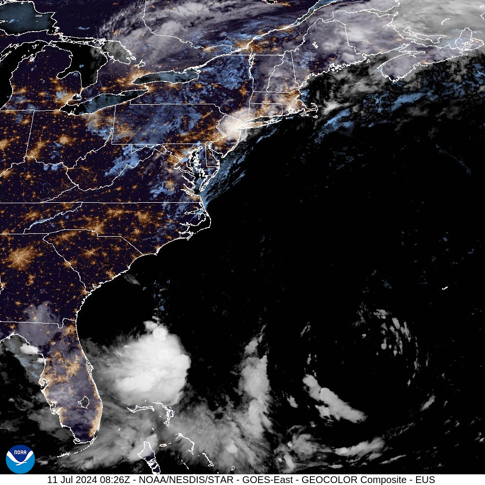
Look at the friggin' size of this thing!