ADVERTISEMENT

The OFFICIAL March 13-14 Winter Weather Thread (This is the B1G 1)

Please - you usually focus on the least snowy scenario - that's why you piss off everyone on AmericanWx and got 5-posted a few times. I talked all about the bad Euro run and the NAM in my posts above - I try to provide balance. Even @camdenlawprof called you out on it yesterday. And there's nothing wrong with Kuchera maps if you know their limitations - they're no more biased than the 10:1 ratio maps.

What do you mean "even camdenlawprof?" I'm not offended, just curious.
 
  • Like
Reactions: bac2therac
I've never had a different screen name - What is your point? Do you think calling guessed Tuesday storm amounts a "lock" on Saturday is legitimate/useful?

I could care less about your beef with the word "lock".

I just noticed that, apparently, you posted absolutely nothing for two years and then all of your posts have come in the last 2 months, specifically in weather threads.

This tell me that you posted, previously, under a different screen name. If you use any of the same registration data, your stats "stick". So in denying it, what you're telling us is that you were a member here for two years before you posted a single word.

Which I find to be not credible.
#PRAIRIEFIRE
 
  • Like
Reactions: KingHigh
What do you mean "even camdenlawprof?" I'm not offended, just curious.
I meant it in the nicest way, that you're one of the most dispassionate, logical, level-headed posters we have, who rarely criticizes anyone, so when you made the comment you made, it has very high credibility.
 
This bantering back and forth on the weather threads used to be mildly entertaining. It's not fun anymore, can we just stick to what might happen when most of us are on the roads Tuesday?

I'm with you and am done bickering; although my last comment (hopefully) is it's astounding how much attention is being paid to the word "lock" - I said it "looks like a lock" which is not the same, IMO, as saying it's a lock. Perhaps a poor choice of words, but time to move on. I'm going to try to stick to weather posts from here on.
 
There's been some solid discussion on AMWx while I was out. And the bulk of that discussion is a pretty damn good explanation about why this won't be a huge storm.
 
I'm with you and am done bickering; although my last comment (hopefully) is it's astounding how much attention is being paid to the word "lock" - I said it "looks like a lock" which is not the same, IMO, as saying it's a lock. Perhaps a poor choice of words, but time to move on. I'm going to try to stick to weather posts from here on.
I'm amazed you put up with it. Lesser posters would have left by now. But as others have said, we really appreciate your posts on these weather threads. I visit here for the most up to date and accurate information on upcoming storms.
Hilarious folks are hung up on "lock". I have a prediction-this is not the last post that you will see that word. You will be bombarded with that word if the storm does not pan out. That' a lock!
 
RU#s - just know there are a number of posters here that truly appreciate what you post here and I generally skip over the overly critical posts that some ppl throw your way.

And I agree with Camdenlawprof - some posts recently have crossed lines of civility.
 
This pro met, JetsPens87, made a great post earlier on AmericanWx that, if this storm does end up underperforming, will be remembered for possibly pointing out why. Reallly good stuff, if you're interested. Talks all about how the models didn't take into account that well the mid-level features and interactions of the main low coming up the coast and an upper low well to the west, "robbing the main low of moisture" due to subsidence and leading to a lot less precip than was originally being forecast.

The lack of dynamics due to later phasing could also lead to less precip for our area, meaning maybe a 6-12" storm vs. a 12-18" storm. Not sure he'll be right and plenty of other pros who still think the setup is great for 12-18" (like those at the NWS obviously, who aren't slouches), but he certainly has an interesting perspective. OK, 00Z models about to start coming out soon...

https://www.americanwx.com/bb/topic...orm-potential/?do=findComment&comment=4503988
 
There is a reason why it's called a weather FORCAST....it's an estimate based on the known data at the time of the prediction

A FORCAST based on dynamics which creates uncertainty to various degrees

Why people can't see this and understand that the dynamics are uncertain and not shoot the guy making best estimates given known data
 
RU#s - just know there are a number of posters here that truly appreciate what you post here and I generally skip over the overly critical posts that some ppl throw your way.

And I agree with Camdenlawprof - some posts recently have crossed lines of civility.

Count me in as one who appreciates RU#s forecast discussions. I find more detailed, accurate and up-to-the-minute info here as compared to anywhere else. I also know that forecasts aren't guarantees. Mother Nature's forces can be unpredictable. It's an inexact science.

That being said, I'm wishcasting myself for a late start and lower snow totals for the I-80 corridor heading west. I'm trying for as early a start Monday night as possible to head west and to get as far west as I can, hopefully getting past the mountain range and their higher snow totals and more treacherous conditions.
 
Another thing not to forget, that some seem too, is not everyone is this thread lives in central NJ.

I'm up in Kinnelon. NAM just showed coast and SNJ getting mostly rain. City 4-8inches. Me in Kinnelon? 17 inches. Parts of Hudson Valley, 20+

The posts providing actual info, either way, are welcome. The more frequent posts now simply telling another poster why their wrong is getting tiresome
 
There is a reason that huge March storms are very rare....mid March storms even rarer...my quibble with Numbers is his overconfidence in a huge storm coming when he knows this. A step back and a nod to what could go wrong is always the best approach in March. These storms are rare because they perfect conditions against climo and that things go wrong..what a model says 7 or 4 days is too early to declare victory. We are getting a storm thats for sure and it could be big or it could be just a moderate storm or it could be a slopfest...so much to be determined as models continue to shift as they usually do. He is a snow lover so he is going to be optimistic and run with it. I do not necessarily mind snow but do not see the purpose of more than 3-4 inches
 
There is a reason that huge March storms are very rare....mid March storms even rarer...my quibble with Numbers is his overconfidence in a huge storm coming when he knows this. A step back and a nod to what could go wrong is always the best approach in March. These storms are rare because they perfect conditions against climo and that things go wrong..what a model says 7 or 4 days is too early to declare victory. We are getting a storm thats for sure and it could be big or it could be just a moderate storm or it could be a slopfest...so much to be determined as models continue to shift as they usually do. He is a snow lover so he is going to be optimistic and run with it. I do not necessarily mind snow but do not see the purpose of more than 3-4 inches

Good post . I appreciate these threads and the info you and numbers provide.
 
  • Like
Reactions: RU848789
There is a reason that huge March storms are very rare....mid March storms even rarer...my quibble with Numbers is his overconfidence in a huge storm coming when he knows this. A step back and a nod to what could go wrong is always the best approach in March. These storms are rare because they perfect conditions against climo and that things go wrong..what a model says 7 or 4 days is too early to declare victory. We are getting a storm thats for sure and it could be big or it could be just a moderate storm or it could be a slopfest...so much to be determined as models continue to shift as they usually do. He is a snow lover so he is going to be optimistic and run with it. I do not necessarily mind snow but do not see the purpose of more than 3-4 inches

Totally get that. But most of us are aware of the bias he has for snow, and the bias you have for less snow. We don't need posts with you two calling each other out back and forth. After years, it's getting very old. It's like your surprised every storm when he hypes it up
 
0z nam snow map... you see that serious mixing and changeover issues near that 1-95 corridor cutting back on totals verbatim. I believe the 3K Para NAM was colder and snowier
with 12-20 inches for the region
IMG_2424.thumb.PNG.39e8c2919e564c36cfa669971b7eda3d.PNG
 
0z nam snow map... you see that serious mixing and changeover issues near that 1-95 corridor cutting back on totals verbatim. I believe the 3K Para NAM was colder and snowier
with 12-20 inches for the region
IMG_2424.thumb.PNG.39e8c2919e564c36cfa669971b7eda3d.PNG

This was the map I was referring to where it could easily be said the storm is being overhyped for many on this board. But someone like myself is in the 15-18 inch range. GFS will be interesting
 
I know i'm tired of getting the brunt of these snowstorms up here in CT, they just had 10-20" for the shoreline(new haven) on the local news but i'm praying for anything less than 8 inches
 
Count me in as one who appreciates RU#s forecast discussions. I find more detailed, accurate and up-to-the-minute info here as compared to anywhere else.

me too.

i am a #'s fan as well.
i typically skip all the noise posts and just read #'s and bac's. very helpful.
they may go at each other but i think they pair up well by providing different reads.
 
The Gfs still a solid hit 8-12...but the Canadian went ballistic with 18-26 inch totals lol

Lots of differences with models right now...all indentify a big storm but so many different outputs. Lots of runs to go before any real confidence in any one model
..its the trends that develop that will need to be monitored
 
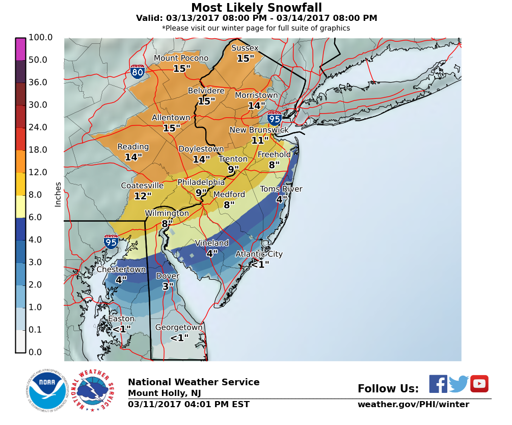
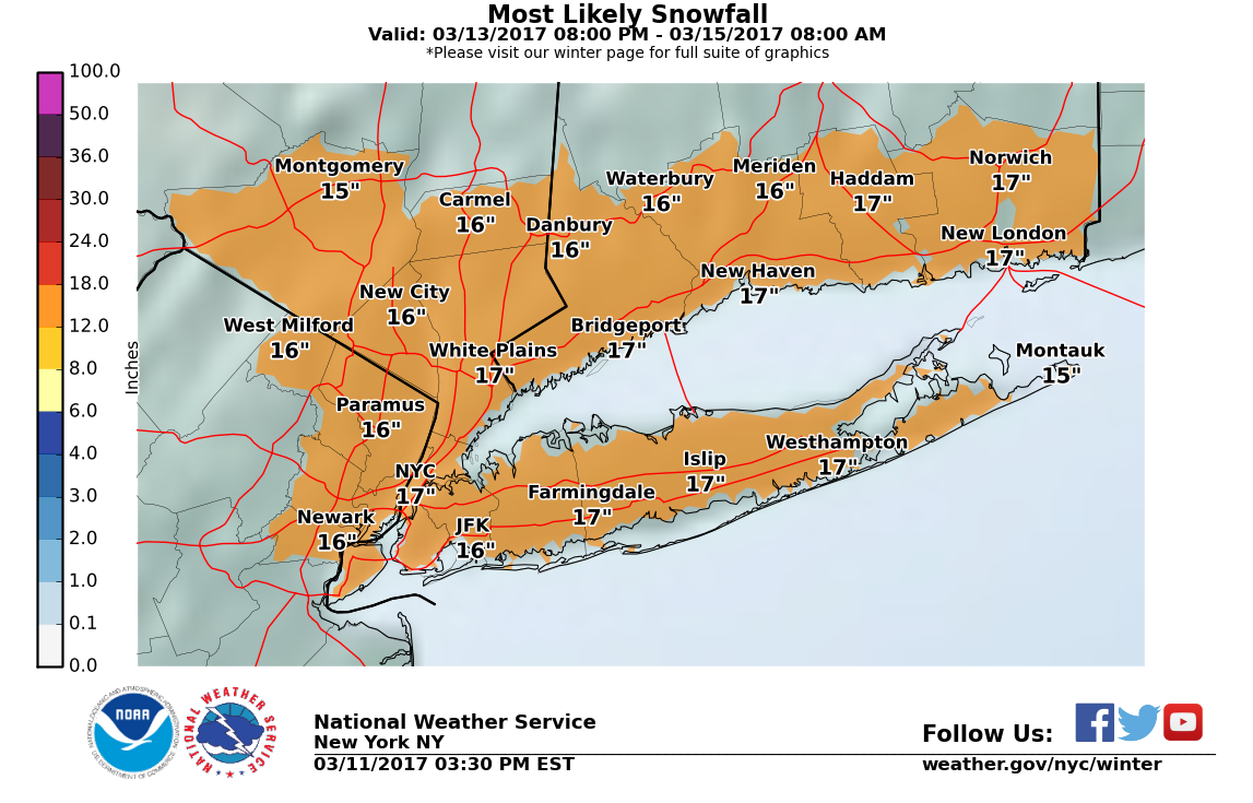
Very positive trends for a big snowstorm tonight, so far, for the Philly-NYC corridor and the rest of NJ, eastern PA, NYC/LI/Hudson Valley/CT. Looking like the NWS-NYC forecasts of 12-18" for the NYC Metro are reasonable and the 8-12" forecast for I-95 and 12-16" NW of there in NJ/PA (with 4-8" at the immediate coast) by the NWS in Philly are in pretty good shape.

  • NAM is the only iffy model, with rain making it to I-95, keeping accumulations down to 6-10" w/10-18" NW of there and 2-6" towards the coast.
  • However, the 3km-Para-NAM (higher resolution) gives a general 8-12" for almost everyone (except far SE NJ), although the model only goes out to 60 hours (7 am Tuesday) and it's still snowing well at that point, so maybe 10-15".
  • GFS looks much better than earlier today, with a general 8-14" for the entire area.
  • The CMC (Canadian) is a "Mother of God" storm with 18-30" area-wide - an all out blizzard for many. This is the potential this storm has - can't be sure for awhile if that will be realized though.
  • The RGEM (Canadian mesoscale, shorter term model, like the US NAM) shows a general 8-14".
  • 12:30 am edit: the UK is like the CMC with 15-25" of snow area wide.
  • And holy crap the Euro is also 15-25" area wide; some mixing/rain south of Asbury Park and especially south of AC.

rkJPKXC.png


egN1aI6.png


Edit: DT/WxRisk just posted his "first guess" map. 12-18", basically, for the entire area, except far southern NJ.

https://www.facebook.com/WxRisk/

zvsutf.jpg
 
Last edited:
Totally get that. But most of us are aware of the bias he has for snow, and the bias you have for less snow. We don't need posts with you two calling each other out back and forth. After years, it's getting very old. It's like your surprised every storm when he hypes it up

I love snow. I have no conscious bias for hyping or over-reporting snow. My primary aim is communicating the most accurate information I can in a way that is easy to understand, although clarity can be a bit at odds with being thorough. I like to have fun with this stuff, too, which gets harder every year, which is why I now post weather info more to Facebook, as people are simply nicer on FB than they are on anonymous message boards. It's not that I mind legitimate arguments over forecasts - it's the petty stuff that's annoying and I know I should ignore it, but that's hard to do sometimes.
 
  • Like
Reactions: TRU2RU
I love snow. I have no conscious bias for hyping or over-reporting snow. My primary aim is communicating the most accurate information I can in a way that is easy to understand, although clarity can be a bit at odds with being thorough. I like to have fun with this stuff, too, which gets harder every year, which is why I now post weather info more to Facebook, as people are simply nicer on FB than they are on anonymous message boards. It's not that I mind legitimate arguments over forecasts - it's the petty stuff that's annoying and I know I should ignore it, but that's hard to do sometimes.
Several people asked earlier, any time line yet? Want to know how driving will be Tuesday AM around 9. Would like to go from Sayreville to So. Brunswick & back.
 
Several people asked earlier, any time line yet? Want to know how driving will be Tuesday AM around 9. Would like to go from Sayreville to So. Brunswick & back.

Thought I posted on that, but maybe not or could be buried deep in my ramblings, lol. Anyway, expect the snow to start around maybe 9-10 pm Monday around Philly and around midnight or so in Central Jersey. Tuesday at 9 am is likely to be the height of the storm and if we get the 12-18" version, I'd say you'd be nuts to do that ride then, and even if we get the 8-12" version, it would likely be dicey.

One comment: since it's going to be in the mid-20s when the snow starts, it will stick immediately on all surfaces at night and we'll likely have 6+" on the ground by 7-8 am on Tuesday. Furthermore, temps during the day on Tuesday will struggle to get to 32F and with snow already on all surfaces, the March sun will play much less of a role in melting than it did on Friday.

Once snow is covering the dark paved surfaces, it reflects 80-90% of the solar radiation that makes it to the ground (whereas paved surfaces only reflect 10-20% of that radiation, absorbing it which warms those surfaces). So instead of being able to melt maybe 3/4" of snow per hour on paved surfaces during about 9 am to 3 pm, the melting rate of snow that has already fallen is more like 1/4" per hour.
 
  • Like
Reactions: Cabana Man
Count me in as one who appreciates RU#s forecast discussions. I find more detailed, accurate and up-to-the-minute info here as compared to anywhere else. I also know that forecasts aren't guarantees. Mother Nature's forces can be unpredictable. It's an inexact science.

That being said, I'm wishcasting myself for a late start and lower snow totals for the I-80 corridor heading west. I'm trying for as early a start Monday night as possible to head west and to get as far west as I can, hopefully getting past the mountain range and their higher snow totals and more treacherous conditions.
I def am one to just see what weather info RU# posts
 
I love snow. I have no conscious bias for hyping or over-reporting snow. My primary aim is communicating the most accurate information I can in a way that is easy to understand, although clarity can be a bit at odds with being thorough. I like to have fun with this stuff, too, which gets harder every year, which is why I now post weather info more to Facebook, as people are simply nicer on FB than they are on anonymous message boards. It's not that I mind legitimate arguments over forecasts - it's the petty stuff that's annoying and I know I should ignore it, but that's hard to do sometimes.

I love snow also, which is why I like your posts so much! I just wish you could stop engaging Bac and RU4real as much as you do in these threads.

Bac - You provide good info as well, and I have no problem with the counter posts. Reality is few places get best case scenarios if you like snow

RU4real has just always bothered me because he will complain how snow is dangerous for people but them runs contests for Hurricane season
 
  • Like
Reactions: RU848789
Euro goes big snow also for the most of the state. If your looking for trends the 0z runs trended to a more snowier solution
 
Kind of repeating the post above. Very positive trends for a big snowstorm on the 0Z models tonight for the Philly-NYC corridor and the rest of NJ, eastern PA, NYC/LI/Hudson Valley/CT. Looking like the NWS-NYC forecasts of 12-18" for the NYC Metro are reasonable and the 8-12" forecast for I-95 and 12-16" NW of there in NJ/PA (with 4-8" at the immediate coast) by the NWS in Philly are in pretty good shape and are probably underdone, even.

Might see blizzard watches extended to the NJ coastal counties. Still 48 hours from the start of the storm, but this is near consensus on a major to historic snowstorm with just the one outlier (the NAM - and even that's a major snowstorm from the NJ TPK and NW of there).

Doesn't mean things still can't go south, but the models get more and more accurate as the event nears. In addition, it's very important to note that this was, by far, the best set of input data ingested into the models, as the NHC flew some data gathering flights and more balloons were sent up, plus, most importantly, one of the major players, was finally over land for these model runs, meaning the initial condition data were much more complete for that feature, all of which should have improved the accuracy of the model runs.
  • NAM is the only iffy model, with rain making it to I-95, keeping accumulations down to 6-10" w/10-18" NW of there and 2-6" towards the coast.
  • However, the 3km-Para-NAM (higher resolution) gives a general 8-12" for almost everyone (except far SE NJ), although the model only goes out to 60 hours (7 am Tuesday) and it's still snowing well at that point, so maybe 10-15".
  • GFS looks better than earlier today, with a general 8-14" for the entire area.
  • The CMC (Canadian) is a "Mother of God" storm with 18-30" area-wide - an all out blizzard for many. This is the potential this storm has - can't be sure for awhile if that will be realized though.
  • The RGEM (Canadian mesoscale, shorter term model, like the US NAM) shows a general 8-14".
  • The UK is like the CMC with 15-25" of snow area wide.
  • And the Euro is also 15-25" area wide; some mixing/rain south of Toms River, but still a big hit.
Edit at 7:45 am to include updated NWS maps; Mt. Holly increased snowfall across the board, especially near the coast where less mixing/rain is now expected. NWS-NYC had no major changes - still 12-18" everywhere.

17309048_10210568730968532_7285620675588476207_n.jpg


17309024_10210568756569172_8538191374931053355_n.jpg
 
Last edited:
Philly News just put out 12-16 for Lehigh Valley. 10-14 for 95 corridor and than lessoning towards the coast we very little in Cape May County. We shall see.
 
My daughter has a degree in atmospheric science from Cornell and has worked as a meteorologist. I showed her this thread and asked her if #'s knew what he was talking about. She confirmed that his analysis of the different models showed that he does. I don't view his posts as over hyping at all.
 
I love snow. I have no conscious bias for hyping or over-reporting snow. My primary aim is communicating the most accurate information I can in a way that is easy to understand, although clarity can be a bit at odds with being thorough. I like to have fun with this stuff, too, which gets harder every year, which is why I now post weather info more to Facebook, as people are simply nicer on FB than they are on anonymous message boards. It's not that I mind legitimate arguments over forecasts - it's the petty stuff that's annoying and I know I should ignore it, but that's hard to do sometimes.

Keep up the good work and don't let the idiots get to you. I am not sure what I would do without these weather threads. I have honestly truly come to rely on them to help me understand what is going to happen. Lots of places to see the end output, but I also like to understand the thought process behind how we will get there and what the risks are. You do a great job of breaking that down in an understandable manner.
 
My daughter has a degree in atmospheric science from Cornell and has worked as a meteorologist. I showed her this thread and asked her if #'s knew what he was talking about. She confirmed that his analysis of the different models showed that he does. I don't view his posts as over hyping at all.
I always liked reading RU#s weather posts before but since my cousin who just recently graduated with an undergrad and masters degree from Cornell in Engineering and Robotics and now she works for Lockheed-Martin making some crazy cool shit and got an award for one of the top new engineers, I will trust your daughter's opinion and I like and respect RU#s insight even more!
 
ADVERTISEMENT
ADVERTISEMENT