or 50 passing yards and an INT or 300 yards and 3 TDs? 😂Yes it is, just like a gameday forecast where we're agonizing over whether we might get 0.01" of rain or 00.05" of rain, lol, and we just can't know that level of detail until the event and everyone is watching their radars and the sky.


Colleges
- American Athletic
- Atlantic Coast
- Big 12
- Big East
- Big Ten
- Colonial
- Conference USA
- Independents (FBS)
- Junior College
- Mountain West
- Northeast
- Pac-12
- Patriot League
- Pioneer League
- Southeastern
- Sun Belt
- Army
- Charlotte
- East Carolina
- Florida Atlantic
- Memphis
- Navy
- North Texas
- Rice
- South Florida
- Temple
- Tulane
- Tulsa
- UAB
- UTSA
- Boston College
- California
- Clemson
- Duke
- Florida State
- Georgia Tech
- Louisville
- Miami (FL)
- North Carolina
- North Carolina State
- Pittsburgh
- Southern Methodist
- Stanford
- Syracuse
- Virginia
- Virginia Tech
- Wake Forest
- Arizona
- Arizona State
- Baylor
- Brigham Young
- Cincinnati
- Colorado
- Houston
- Iowa State
- Kansas
- Kansas State
- Oklahoma State
- TCU
- Texas Tech
- UCF
- Utah
- West Virginia
- Illinois
- Indiana
- Iowa
- Maryland
- Michigan
- Michigan State
- Minnesota
- Nebraska
- Northwestern
- Ohio State
- Oregon
- Penn State
- Purdue
- Rutgers
- UCLA
- USC
- Washington
- Wisconsin
High School
- Illinois HS Sports
- Indiana HS Sports
- Iowa HS Sports
- Kansas HS Sports
- Michigan HS Sports
- Minnesota HS Sports
- Missouri HS Sports
- Nebraska HS Sports
- Oklahoma HS Sports
- Texas HS Hoops
- Texas HS Sports
- Wisconsin HS Sports
- Cincinnati HS Sports
- Delaware
- Maryland HS Sports
- New Jersey HS Hoops
- New Jersey HS Sports
- NYC HS Hoops
- Ohio HS Sports
- Pennsylvania HS Sports
- Virginia HS Sports
- West Virginia HS Sports
ADVERTISEMENT
Install the app
How to install the app on iOS
Follow along with the video below to see how to install our site as a web app on your home screen.
Note: This feature may not be available in some browsers.
You are using an out of date browser. It may not display this or other websites correctly.
You should upgrade or use an alternative browser.
You should upgrade or use an alternative browser.
OT: Could the snow drought end next weekend (1/7)? Maybe...
- Thread starter RU848789
- Start date
the rgem and canadian have been pretty consistent and are close to what Mt Holly is thinking...by the way the GFS actually was weaker and gave us less snow verbatim on the clown maps, in fact the last two runs from the 12z outlier..Nice hit on the gfs. Colder…this storms gonna come down to the buzzer
its really the nam on its own...lets see what euro says but the rgem, ukmet and canadian are tough to go against when lockstep
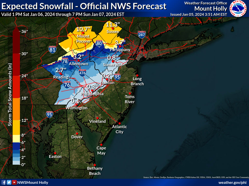
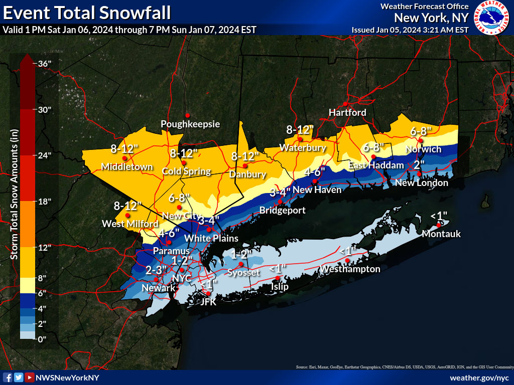
Between the high forecast uncertainty and having lots of things planned for tomorrow and Saturday, I'll be posting less in this thread from now through Sat afternoon. Have fun tracking and quibbling, lol. I'll stick with my 2" forecast for my house, but am feeling more confident about reaching that now and feel that 3-4" is definitely not much of a stretch, if we can just get some good intensity to overcome the above 32F surface temps (when we're snowing and not raining); <1" is also a risk. I'm also assuming the NWS-Philly increases their snowfall forecasts to be more in line with NWS-NYC, i.e., with 1-2" for 95 from Trenton to Woodbridge and several inches NW of there. Still 48 hours to go from tonight's 0Z runs, which initialized at 7 pm, which is an eternity.
Fairly pessimistic, but understandable. I'm going more with the GFS/NAM/NBM and even though the Euro took a step back at 0Z, the Euro ensembles didn't really and still show a few inches for the 95 corridor, so I'll go with 1-2" for the 95 corridor from Trenton to NYC, but only an inch or so from Philly to Trenton; I'd have <1" SE of 95 from the Raritan southward and nada near the coast (although they might get an inch later on Sunday with the wrap-around). I'd also go with 2-3" from the NW edge of the 95 corridor from Trenton to Woodbridge over and up to 78 and then I'd go with 3-5" between 78 and 80 (and NW of 287) and then 5"+ north of 80 (and NW of 287), including 8-12" well N of 80 towards 84. I'd also have about 2-4" in the "box" between the TPK and 287 and between 78 and 80. I need to do a map, lol. And 2", still, for my house. Maybe that's all a bit optimistic, especially after just looking at the 6Z NAM, which had a big drop in snowfall for everyone south of 80 (only 1-2" for 95 vs 3-6" at 0Z). But I didn't take the crazy high NAM totals seriously, so not going to panic over one low run of the NAM. If the other models follow suit, then I'll panic, lol.Sticking with my original, very amateurish call from yesterday:
Very little snow south of 78. Probably 1-3 between 78 and 80…then 3-6+ on a very tight gradient from 80 north.
NWS snowfall maps are out and the NWS-Philly upped their snowfall forecasts a bit along 95 and 78 such that there are no longer significant discrepancies between them and the NWS-NYC, as there had been at the boundaries. Still pretty low forecast for 95 with <1" forecast (was zero before), which still looks odd at the boundary of Middlesex (<1") and Union (1-2/2-3").
Its seems like you are the one with the problem not me....Karen
This will be my last response as I (and others I am sure ) am tired of this back and forth . It’s pointless
but you calling anyone a “Karen” is just too funny. You have spent years following #s from message board to message board posting (you admitted) several thousands of posts being a Karen towards #s on this stupid topic? You are the epitome of a Karen.
I’m leaving this matter behind.
You’ll continue to do your weather-Karen thing unendingly
Last edited:

It's the definition of wishcasting.This is what i mean by snow bias
The red tagged mets have repeatedly said dont use these snow maps for this storm but there you go

Many on these board think if they are the last to response, they win. Most times they just look stupid.This will be my last response as I (and others I am sure ) am tired of this back and forth . It’s pointless
but you calling anyone a “Karen” is just too funny. You have spent years following #s from message board to message board posting (you admitted) several thousands of posts being a Karen towards #s on this stupid topic? You are the epitome of a Karen.
I’m leaving this matter behind.
You’ll continue to do your weather-Karen thing unendingly
For those in South Monmouth/Northern Ocean County, here's the latest from NWS:
Saturday
Rain, mainly after 1pm. High near 42. Southwest wind 5 to 15 mph becoming east in the morning. Chance of precipitation is 80%. New precipitation amounts between a tenth and quarter of an inch possible.
Saturday Night
Rain. Low around 37. Breezy, with an east wind 20 to 25 mph, with gusts as high as 40 mph. Chance of precipitation is 100%. New precipitation amounts between 1 and 2 inches possible.
Sunday
Rain likely before 4pm, then a chance of rain and snow. Cloudy, with a high near 42. Breezy, with a northwest wind 15 to 20 mph, with gusts as high as 30 mph. Chance of precipitation is 60%. Little or no snow accumulation expected.
This will be my last response as I (and others I am sure ) am tired of this back and forth . It’s pointless
but you calling anyone a “Karen” is just too funny. You have spent years following #s from message board to message board posting (you admitted) several thousands of posts being a Karen towards #s on this stupid topic? You are the epitome of a Karen.
I’m leaving this matter behind.
You’ll continue to do your weather-Karen thing unendingly
Listen...the potential for a flooding with 3 plus inches of rain is real....and i didnt start a thread on it but if you want to be a **** and quibble like a Karen that is your priority.
Last edited:
Between the high forecast uncertainty and having lots of things planned for tomorrow and Saturday, I'll be posting less in this thread from now through Sat afternoon. Have fun tracking and quibbling, lol. I'll stick with my 2" forecast for my house, but am feeling more confident about reaching that now and feel that 3-4" is definitely not much of a stretch, if we can just get some good intensity to overcome the above 32F surface temps (when we're snowing and not raining); <1" is also a risk. I'm also assuming the NWS-Philly increases their snowfall forecasts to be more in line with NWS-NYC, i.e., with 1-2" for 95 from Trenton to Woodbridge and several inches NW of there. Still 48 hours to go from tonight's 0Z runs, which initialized at 7 pm, which is an eternity.
There was never much uncertainty with this storm but you certainly did put some faith in the NAM and gfs even as red tagged mets were telling you to avoid the clown maps and look under the hood. Soundings for this storm were never good
Could there be a surprise..there always is somewhere but its not modelled anywhere
Mt Holly did a good job not waffling
Not blaming you at all. I'm just enjoying the NAM doing NAM things, in all its NAM glory. It won't be long until the warm ocean temps knock the NAM back into reality and the weenies reach the Bargaining stage.
Great call!
As said before:For those in South Monmouth/Northern Ocean County, here's the latest from NWS:
Saturday
Rain, mainly after 1pm. High near 42. Southwest wind 5 to 15 mph becoming east in the morning. Chance of precipitation is 80%. New precipitation amounts between a tenth and quarter of an inch possible.
Saturday Night
Rain. Low around 37. Breezy, with an east wind 20 to 25 mph, with gusts as high as 40 mph. Chance of precipitation is 100%. New precipitation amounts between 1 and 2 inches possible.
Sunday
Rain likely before 4pm, then a chance of rain and snow. Cloudy, with a high near 42. Breezy, with a northwest wind 15 to 20 mph, with gusts as high as 30 mph. Chance of precipitation is 60%. Little or no snow accumulation expected.
This will be my last response as I (and others I am sure ) am tired of this back and forth . It’s pointless
but you calling anyone a “Karen” is just too funny. You have spent years following #s from message board to message board posting (you admitted) several thousands of posts being a Karen towards #s on this stupid topic? You are the epitome of a Karen.
I’m leaving this matter behind.
You’ll continue to do your weather-Karen thing unendingly
I'm tired of it.
Philadelphia stations are continuing the pull back on amount of snow. Coating to an inch in the city with 6ABC saying a coating in the city (not the airport where the official number comes from) is most likely. Poconos are the guarantee all snow.
Tuesday is a much bigger concern for the Delaware Valley with flooding very likely along the Schuylkill and the Delaware.
Tuesday is a much bigger concern for the Delaware Valley with flooding very likely along the Schuylkill and the Delaware.
My sister was planning on driving from Morristown to. Washington DC on Saturday and driving back Sunday morning.A possible winter storm thread 6 days out (arriving late Sat with most precip on Sunday) would normally get laughed at (by me, too, lol), but it's been so long since we've even had a decent threat that I figured people might want to know, even if it's a very fragile setup that could easily miss us or bring everyone but those well inland mostly rain. As DT/WxRisk, who has been on top of this threat for days always says, look for all the things that can go wrong in a possible snowstorm forecast, as it's often hard to get conditions just right for snow for the 95 corridor.
In this case, there's not a lot of cold air to work with and the track has to be perfect for us to snow for this potential Miller B storm, in which a primary low approaches from the west (TN/KY typically) and transfers its energy to a secondary coastal low off the NC/VA coast, which becomes the main storm as a nor'easter coming up the coast (pulling in both Gulf and Atlantic moisture feeds), i.e., a snowstorm is a real "thread the needle" situation.
Right now, the latest operational model cycle (12Z, which just came out) shows everything from a major snowstorm to our south (the GFS, with south of LBI getting hit good), to a major rainstorm for 95/coast, but a major snowstorm well inland of 95 and a mix in-between (the UK/CMC) to a major snowstorm for 95 and inland, but mostly rain at the coast (the Euro). And last night's models all showed a major winter storm with similarly varying outcomes, as uncertainty is just too great to make any predictions yet. The important thing is consensus on a storm with the details to be determined later. At this range, the ensemble forecasts are probably better to look at and they're all showing potential for some snowfall, but also some rainfall for most of us.
Good thread on AmericanWx below, and nice NWS-Philly discussion, too. At least snow lovers have something to track. Also, there's a chance of some light snow (<1") on Thursday morning.
https://www.americanwx.com/bb/topic...eases-jan-10-and-beyond-damaging-wind/page/7/
Area Forecast Discussion
National Weather Service Mount Holly NJ
900 AM EST Mon Jan 1 2024
LONG TERM /THURSDAY THROUGH SUNDAY/...
Saturday a secondary front tries to slip southward across the
area just ahead of an approaching low pressure form the Gulf.
Just how much impact this reinforcing front and the high
pressure moving in behind it has could make all the difference
regarding what type of weather the incoming Gulf system brings.
Potential exists for the first significant snowfall in nearly 2
years, but there remains great uncertainty, since lesser impact
from the high to the north may allow the system to stay further
northwest and bring more rain vs snow. Rain of course will bring
its own problems given how wet it has been of late, and onshore
flow will create another coastal flood concern. Bottom line is
there is a definite potential for an impactful system this
weekend, but exactly what flavor those impacts take remains to
be seen. Anyone with plans this weekend should keep very close
eyes on the forecast as there is a high potential for
fluctuations.
How strongly should I advise against it?
Don Sutherlands from Americanwx had a couple of outstanding posts about tracking this storm..will copy them here
n terms of the concern about "waffling," there was a lot of good analysis provided by numerous people. Wdrag, Bluewave, Dark Star, among others, provided good insight. Others provided good arguments why the event could be better. It should be noted that people can provide good insight and still be wrong in the end. Forecasting is inherently uncertain and all who engage in it encounter error from time to time.
From my vantage point (which has been wrong at times and will again be wrong), there were persistent "red flags" that urged caution from the onset: Overall synoptic pattern, persistent surface temperature projections, emergent soundings data, and risks associated with extreme outlier solutions that lacked strong support.
For illustrative purposes to show how these "red flags" came into play, excerpts from some posts follow. One should also read through Bluewave's posts, as he consistently raised issues that are now playing out e.g., the impact of the upstream trough in the Southwest.
January 3:
Of concern remains surface temperatures that will be above freezing for most or all of the event. Soundings will become increasingly important as the event draws closer, but this still looks to be a wet, low ratio snowfall for NYC and its nearby suburbs.
January 3:
The importance of recognizing that the upcoming event will be a low- to very low-ratio event in New York City cannot be overstated. Most of the guidance keeps NYC above freezing throughout the storm. While model solutions showing 6"+ snow appear attractive, the early surface temperature forecasts and early soundings suggest that such figures based on a 10:1 ratio will likely be far off the mark.
January 4:
There was more downside risk than upside risk. Unfortunately, even at this point in time, there still remains somewhat more downside risk than upside risk, namely that the 1" of slushy snow to perhaps 3", if everything went well, could evolve into a coating to an inch-type scenario.
The low ratios (high confidence assumption given the consistently forecast temperatures) rendered 10:1 snowfall maps irrelevant. That included individual ensemble maps based on 10:1 ratios. In both cases, the operational and ensemble maps overstated what was likely. For an illustrative example, maps assessing the probability of 4" or more snowfall were actually assessing the probability of 2" or more snow in and around NYC and along the coastal plain, because their 10:1 ratios were not realistic.
As a result of the overnight guidance, the probability that New York City's streak without 1" or more daily snowfall, which will reach 690 days today, will continue has increased.
January 4:
Be wary of snow maps e.g., the 18z NAM's depictions...
A significant share of the precipitation is rain or mixed precipitation, not snow. For example, at 75 hours when the NAM is piling on the digital snow, the sounding shows the above freezing layer extending almost to 975 mb with above-freezing surface temperatures. Over New York City's urban heat island, that's not accumulating snow. The precipitation ends as snow, but accumulations will likely be limited. Outlier models for heavy snowfall that lack support should be disregarded given the marginal air mass and historic experience with snowfall at above freezing temperatures in New York City.
Quite bluntly, those who consistently post extreme solutions or earliest calls but wind up wrong over and over again lack skill. They can spin it any way they like, but skill is a function of consistent accuracy. Nothing more. Unfortunately, the public and those who read social media don't realize the absence of skill among those who take sensationalist stands. Thus, the misleading perception that meteorologists 'can't forecast' prevails even as those perceptions are far off the mark.
n terms of the concern about "waffling," there was a lot of good analysis provided by numerous people. Wdrag, Bluewave, Dark Star, among others, provided good insight. Others provided good arguments why the event could be better. It should be noted that people can provide good insight and still be wrong in the end. Forecasting is inherently uncertain and all who engage in it encounter error from time to time.
From my vantage point (which has been wrong at times and will again be wrong), there were persistent "red flags" that urged caution from the onset: Overall synoptic pattern, persistent surface temperature projections, emergent soundings data, and risks associated with extreme outlier solutions that lacked strong support.
For illustrative purposes to show how these "red flags" came into play, excerpts from some posts follow. One should also read through Bluewave's posts, as he consistently raised issues that are now playing out e.g., the impact of the upstream trough in the Southwest.
January 3:
Of concern remains surface temperatures that will be above freezing for most or all of the event. Soundings will become increasingly important as the event draws closer, but this still looks to be a wet, low ratio snowfall for NYC and its nearby suburbs.
January 3:
The importance of recognizing that the upcoming event will be a low- to very low-ratio event in New York City cannot be overstated. Most of the guidance keeps NYC above freezing throughout the storm. While model solutions showing 6"+ snow appear attractive, the early surface temperature forecasts and early soundings suggest that such figures based on a 10:1 ratio will likely be far off the mark.
January 4:
There was more downside risk than upside risk. Unfortunately, even at this point in time, there still remains somewhat more downside risk than upside risk, namely that the 1" of slushy snow to perhaps 3", if everything went well, could evolve into a coating to an inch-type scenario.
The low ratios (high confidence assumption given the consistently forecast temperatures) rendered 10:1 snowfall maps irrelevant. That included individual ensemble maps based on 10:1 ratios. In both cases, the operational and ensemble maps overstated what was likely. For an illustrative example, maps assessing the probability of 4" or more snowfall were actually assessing the probability of 2" or more snow in and around NYC and along the coastal plain, because their 10:1 ratios were not realistic.
As a result of the overnight guidance, the probability that New York City's streak without 1" or more daily snowfall, which will reach 690 days today, will continue has increased.
January 4:
Be wary of snow maps e.g., the 18z NAM's depictions...
A significant share of the precipitation is rain or mixed precipitation, not snow. For example, at 75 hours when the NAM is piling on the digital snow, the sounding shows the above freezing layer extending almost to 975 mb with above-freezing surface temperatures. Over New York City's urban heat island, that's not accumulating snow. The precipitation ends as snow, but accumulations will likely be limited. Outlier models for heavy snowfall that lack support should be disregarded given the marginal air mass and historic experience with snowfall at above freezing temperatures in New York City.
Those maps are a huge problem. I've increasingly starting calling out and verifying the extreme maps posted on Twitter. Those posts provide no useful guidance and only serve to undermine professional credibility of meteorologists, many of whom are outstanding, but whose insights and forecasts are drowned out by the noise of the extreme posts, blind rush to be first to make a call, etc. Indeed, a female TV meteorologist from Philadelphia was criticized on social media for not making an early call for snowfall amounts when uncertainty was high. She made a forecast for a coating to an inch in Philadelphia yesterday (her first call). That looks good. Contrast that to the social media maps showing 4"-8" or even 4"-12" in Philadelphia that dated as far back as January 1.2 hours ago, Brian5671 said:
Part of it is twitter and social media showing the snowiest maps....the general public here thinks a 12 inch storm is coming lol.
Quite bluntly, those who consistently post extreme solutions or earliest calls but wind up wrong over and over again lack skill. They can spin it any way they like, but skill is a function of consistent accuracy. Nothing more. Unfortunately, the public and those who read social media don't realize the absence of skill among those who take sensationalist stands. Thus, the misleading perception that meteorologists 'can't forecast' prevails even as those perceptions are far off the mark.
BOOM! Mic drop moment.Quite bluntly, those who consistently post extreme solutions or earliest calls but wind up wrong over and over again lack skill. They can spin it any way they like, but skill is a function of consistent accuracy. Nothing more.
my second call would downgrade central jersey to a coating to 2 inches to cover any low end/high end possibilities...and the higher amounts you will find on grassy colder surfaces. Coast not even sure they see any accumulating snow. For Central Jersey proper should not really be that much of an issue on any main roads which get treated will figure to be treated and then the turn to rain will wash any slushiness away eventually.
once you get north of 78 you could get in the 2-5 inch amounts but no guarantee on those high amounts and northwest jersey still inline for 4-8 inches
looking at a timeframe of between noon and midnight to look to the skies
once you get north of 78 you could get in the 2-5 inch amounts but no guarantee on those high amounts and northwest jersey still inline for 4-8 inches
looking at a timeframe of between noon and midnight to look to the skies
Not seeing any calls for accumulating snow for the coast except perhaps up by Sandy Hook. Here it'll likely be heavy rain and wind that'll be the issue with the coming storm Tuesday - Wednesday being even stronger.my second call would downgrade central jersey to a coating to 2 inches to cover any low end/high end possibilities...and the higher amounts you will find on grassy colder surfaces. Coast not even sure they see any accumulating snow. For Central Jersey proper should not really be that much of an issue on any main roads which get treated will figure to be treated and then the turn to rain will wash any slushiness away eventually.
once you get north of 78 you could get in the 2-5 inch amounts but no guarantee on those high amounts and northwest jersey still inline for 4-8 inches
looking at a timeframe of between noon and midnight to look to the skies
She'll likely not see much snow, if she gets to the TPK in CNJ before about 3 pm, although it'll be a mix of rain and snow falling, but likely not accumulating for some of the drive down (visibiilty could be an issue) and it's no fun to drive in the rain either, especially to DC, but it'll start raining in DC by mid/late morning. Driving back Sunday morning will likely not be an issue after about sunrise - could still see some snow showers up in our area north of about 195 during the day. so could be some visibiilty issues.My sister was planning on driving from Morristown to. Washington DC on Saturday and driving back Sunday morning.
How strongly should I advise against it?

if you have the time and you are vulnerable in these type of storms, start prepping nowNot seeing any calls for accumulating snow for the coast except perhaps up by Sandy Hook. Here it'll likely be heavy rain and wind that'll be the issue with the coming storm Tuesday - Wednesday being even stronger.
This is completely wrong and still is wrong. The uncertainty on snowfall amounts is huge with likely gradients from nada to 6" or more over just 25 miles or so and some models are still showing several inches falling (even if not all accumulating) in the 95 corridor, despite the NWS low predictions.There was never much uncertainty with this storm but you certainly did put some faith in the NAM and gfs even as red tagged mets were telling you to avoid the clown maps and look under the hood. Soundings for this storm were never good
Could there be a surprise..there always is somewhere but its not modelled anywhere
Mt Holly did a good job not waffling
Just look at 12Z runs today. Just looking at Edison, the GFS has 1.8", the CMC has 6.7", the RGEM has 1.8" and the NAM has 4.6". Sure Holmdel or South Brunswick have generally less than 1" from those models, but parts of the 95 corridor (including NB to NYC) have similar modeled snowfalls as Edison.
If that's not huge uncertainty, I don't know what is. Will the large snowfall amounts in the snowier models verify? Likely not, which is why the NWS and others have ~1" to 1-2" accumulations NE of NB along 95, but to not acknowledge the uncertainty is being ignorant.
And Don S's post is great and he's (and others) actually given me props for my scientific approach to guesstimating snowfall in high intensity situations with above 32F surfaces (while chiding me for using the 10:1 maps, which I get, since so many misuse them). Note that my "call" is not much different from yours or Lee Goldberg's and just a bit more than the NWS along 95.
It is snowing like crazy in Little Rock this morning!
Not much to do anymore other than monitor the tidal flooding which has to be pretty robust to affect me these days. Sun AM shouldn't be an issue. Wed AM may need to get the cars into town but too early to tell.if you have the time and you are vulnerable in these type of storms, start prepping now
You putting the plows on the trucks or playing it by ear?
This is a great post by Don and he and I have talked about these topics and social media science ignorance and misinformation (moreso about climate change and COVID really) in a number of exchanges over the years. That's why I generally don't post snowfall maps early on (and if I do, I post them all, so people can see the range of outcomes) and I usually don't make "calls" at all, other than for my house, as I'm not a professional meteorologist. The call I made this morning was unusual for me, but it was nothing extreme.Don Sutherlands from Americanwx had a couple of outstanding posts about tracking this storm..will copy them here
n terms of the concern about "waffling," there was a lot of good analysis provided by numerous people. Wdrag, Bluewave, Dark Star, among others, provided good insight. Others provided good arguments why the event could be better. It should be noted that people can provide good insight and still be wrong in the end. Forecasting is inherently uncertain and all who engage in it encounter error from time to time.
From my vantage point (which has been wrong at times and will again be wrong), there were persistent "red flags" that urged caution from the onset: Overall synoptic pattern, persistent surface temperature projections, emergent soundings data, and risks associated with extreme outlier solutions that lacked strong support.
For illustrative purposes to show how these "red flags" came into play, excerpts from some posts follow. One should also read through Bluewave's posts, as he consistently raised issues that are now playing out e.g., the impact of the upstream trough in the Southwest.
January 3:
Of concern remains surface temperatures that will be above freezing for most or all of the event. Soundings will become increasingly important as the event draws closer, but this still looks to be a wet, low ratio snowfall for NYC and its nearby suburbs.
January 3:
The importance of recognizing that the upcoming event will be a low- to very low-ratio event in New York City cannot be overstated. Most of the guidance keeps NYC above freezing throughout the storm. While model solutions showing 6"+ snow appear attractive, the early surface temperature forecasts and early soundings suggest that such figures based on a 10:1 ratio will likely be far off the mark.
January 4:
There was more downside risk than upside risk. Unfortunately, even at this point in time, there still remains somewhat more downside risk than upside risk, namely that the 1" of slushy snow to perhaps 3", if everything went well, could evolve into a coating to an inch-type scenario.
The low ratios (high confidence assumption given the consistently forecast temperatures) rendered 10:1 snowfall maps irrelevant. That included individual ensemble maps based on 10:1 ratios. In both cases, the operational and ensemble maps overstated what was likely. For an illustrative example, maps assessing the probability of 4" or more snowfall were actually assessing the probability of 2" or more snow in and around NYC and along the coastal plain, because their 10:1 ratios were not realistic.
As a result of the overnight guidance, the probability that New York City's streak without 1" or more daily snowfall, which will reach 690 days today, will continue has increased.
January 4:
Be wary of snow maps e.g., the 18z NAM's depictions...
A significant share of the precipitation is rain or mixed precipitation, not snow. For example, at 75 hours when the NAM is piling on the digital snow, the sounding shows the above freezing layer extending almost to 975 mb with above-freezing surface temperatures. Over New York City's urban heat island, that's not accumulating snow. The precipitation ends as snow, but accumulations will likely be limited. Outlier models for heavy snowfall that lack support should be disregarded given the marginal air mass and historic experience with snowfall at above freezing temperatures in New York City.
Those maps are a huge problem. I've increasingly starting calling out and verifying the extreme maps posted on Twitter. Those posts provide no useful guidance and only serve to undermine professional credibility of meteorologists, many of whom are outstanding, but whose insights and forecasts are drowned out by the noise of the extreme posts, blind rush to be first to make a call, etc. Indeed, a female TV meteorologist from Philadelphia was criticized on social media for not making an early call for snowfall amounts when uncertainty was high. She made a forecast for a coating to an inch in Philadelphia yesterday (her first call). That looks good. Contrast that to the social media maps showing 4"-8" or even 4"-12" in Philadelphia that dated as far back as January 1.
Quite bluntly, those who consistently post extreme solutions or earliest calls but wind up wrong over and over again lack skill. They can spin it any way they like, but skill is a function of consistent accuracy. Nothing more. Unfortunately, the public and those who read social media don't realize the absence of skill among those who take sensationalist stands. Thus, the misleading perception that meteorologists 'can't forecast' prevails even as those perceptions are far off the mark.
Looking forward to watching this even though both teams stink. Snow games are great IMO.
In what looks to be the biggest game impacted by the nor'easter, Sunday’s matchup between the Jets and Patriots at Gillette Stadium could look like a snow globe for the 1 p.m. game.
And while there is no hope for playoffs for either team, who doesn't love to watch a snow game?
In what looks to be the biggest game impacted by the nor'easter, Sunday’s matchup between the Jets and Patriots at Gillette Stadium could look like a snow globe for the 1 p.m. game.
And while there is no hope for playoffs for either team, who doesn't love to watch a snow game?
Last year my son and I drove to northern NJ/PA during early Dec mix type storm to check it out. It was the only snow we saw all season. We crossed the mix line and found ours lives pretty quickly in less then desirable driving conditions on hilly roads along/near the Delaware and turned around lol. Still a fun excursion but not my best work.
you are virtually the only one running around americanwx trying to keep this storm alive somehow wishing it into accumulations despite people who know better telling you...plus for some reason you keep using 10-1 ratios dying on some hill that no one cares aboutThis is completely wrong and still is wrong. The uncertainty on snowfall amounts is huge with likely gradients from nada to 6" or more over just 25 miles or so and some models are still showing several inches falling (even if not all accumulating) in the 95 corridor, despite the NWS low predictions.
Just look at 12Z runs today. Just looking at Edison, the GFS has 1.8", the CMC has 6.7", the RGEM has 1.8" and the NAM has 4.6". Sure Holmdel or South Brunswick have generally less than 1" from those models, but parts of the 95 corridor (including NB to NYC) have similar modeled snowfalls as Edison.
If that's not huge uncertainty, I don't know what is. Will the large snowfall amounts in the snowier models verify? Likely not, which is why the NWS and others have ~1" to 1-2" accumulations NE of NB along 95, but to not acknowledge the uncertainty is being ignorant.
And Don S's post is great and he's (and others) actually given me props for my scientific approach to guesstimating snowfall in high intensity situations with above 32F surfaces (while chiding me for using the 10:1 maps, which I get, since so many misuse them). Note that my "call" is not much different from yours or Lee Goldberg's and just a bit more than the NWS along 95.
Last edited:
That last paragraph, ouch.Don Sutherlands from Americanwx had a couple of outstanding posts about tracking this storm..will copy them here
n terms of the concern about "waffling," there was a lot of good analysis provided by numerous people. Wdrag, Bluewave, Dark Star, among others, provided good insight. Others provided good arguments why the event could be better. It should be noted that people can provide good insight and still be wrong in the end. Forecasting is inherently uncertain and all who engage in it encounter error from time to time.
From my vantage point (which has been wrong at times and will again be wrong), there were persistent "red flags" that urged caution from the onset: Overall synoptic pattern, persistent surface temperature projections, emergent soundings data, and risks associated with extreme outlier solutions that lacked strong support.
For illustrative purposes to show how these "red flags" came into play, excerpts from some posts follow. One should also read through Bluewave's posts, as he consistently raised issues that are now playing out e.g., the impact of the upstream trough in the Southwest.
January 3:
Of concern remains surface temperatures that will be above freezing for most or all of the event. Soundings will become increasingly important as the event draws closer, but this still looks to be a wet, low ratio snowfall for NYC and its nearby suburbs.
January 3:
The importance of recognizing that the upcoming event will be a low- to very low-ratio event in New York City cannot be overstated. Most of the guidance keeps NYC above freezing throughout the storm. While model solutions showing 6"+ snow appear attractive, the early surface temperature forecasts and early soundings suggest that such figures based on a 10:1 ratio will likely be far off the mark.
January 4:
There was more downside risk than upside risk. Unfortunately, even at this point in time, there still remains somewhat more downside risk than upside risk, namely that the 1" of slushy snow to perhaps 3", if everything went well, could evolve into a coating to an inch-type scenario.
The low ratios (high confidence assumption given the consistently forecast temperatures) rendered 10:1 snowfall maps irrelevant. That included individual ensemble maps based on 10:1 ratios. In both cases, the operational and ensemble maps overstated what was likely. For an illustrative example, maps assessing the probability of 4" or more snowfall were actually assessing the probability of 2" or more snow in and around NYC and along the coastal plain, because their 10:1 ratios were not realistic.
As a result of the overnight guidance, the probability that New York City's streak without 1" or more daily snowfall, which will reach 690 days today, will continue has increased.
January 4:
Be wary of snow maps e.g., the 18z NAM's depictions...
A significant share of the precipitation is rain or mixed precipitation, not snow. For example, at 75 hours when the NAM is piling on the digital snow, the sounding shows the above freezing layer extending almost to 975 mb with above-freezing surface temperatures. Over New York City's urban heat island, that's not accumulating snow. The precipitation ends as snow, but accumulations will likely be limited. Outlier models for heavy snowfall that lack support should be disregarded given the marginal air mass and historic experience with snowfall at above freezing temperatures in New York City.
Those maps are a huge problem. I've increasingly starting calling out and verifying the extreme maps posted on Twitter. Those posts provide no useful guidance and only serve to undermine professional credibility of meteorologists, many of whom are outstanding, but whose insights and forecasts are drowned out by the noise of the extreme posts, blind rush to be first to make a call, etc. Indeed, a female TV meteorologist from Philadelphia was criticized on social media for not making an early call for snowfall amounts when uncertainty was high. She made a forecast for a coating to an inch in Philadelphia yesterday (her first call). That looks good. Contrast that to the social media maps showing 4"-8" or even 4"-12" in Philadelphia that dated as far back as January 1.
Quite bluntly, those who consistently post extreme solutions or earliest calls but wind up wrong over and over again lack skill. They can spin it any way they like, but skill is a function of consistent accuracy. Nothing more. Unfortunately, the public and those who read social media don't realize the absence of skill among those who take sensationalist stands. Thus, the misleading perception that meteorologists 'can't forecast' prevails even as those perceptions are far off the mark.
So, take the snow blower out of the shed or no????
Where do you live
You are as clueless with meteorological science and physical chemistry/eng'g as you are with every other science. I'm not doing anything of the kind - I'm merely correcting flawed assumptions and analyses by posters, including some mets, who simply don't understand heat transfer, physical chemistry and phase transitions (crystallization/melting) as well as I do with regard to accumulation/melting. The PhD in chem eng'g and 30+ years experience doing that kind of work (in pharma, but very similar with regard to these areas) matter.you are virtually the only one running around americanwx trying to keep this storm alive somehow wishing it into accumulations despite people who know better telling you...plus for some reason you keep using 10-1 ratios dying on some hill that no one cares about
The 10:1 is more a personal preference as it gives the amount of snow that falls, which I'm very interested in - and Kuchera is a shitty algorithm in many cases for estimated snow on the ground and most don't even know how that algorithm works, so I try to explain the pros and cons of it.
And our arguments/discussions are a give and take on that board, unlike your trolling which gets you banned repeatedly. I'll take the former and you should stop with the latter there and here.
That's great! I did a similar "chase" to find the rain/snow line up by 80/206 back in the early 90s. You might get a chuckle out of the story...Last year my son and I drove to northern NJ/PA during early Dec mix type storm to check it out. It was the only snow we saw all season. We crossed the mix line and found ours lives pretty quickly in less then desirable driving conditions on hilly roads along/near the Delaware and turned around lol. Still a fun excursion but not my best work.
https://rutgers.forums.rivals.com/t...rn-likely-thru-end-of-feb.188004/post-4402414
You are as clueless with meteorological science and physical chemistry/eng'g as you are with every other science. I'm not doing anything of the kind - I'm merely correcting flawed assumptions and analyses by posters, including some mets, who simply don't understand heat transfer, physical chemistry and phase transitions (crystallization/melting) as well as I do with regard to accumulation/melting. The PhD in chem eng'g and 30+ years experience doing that kind of work (in pharma, but very similar with regard to these areas) matter.
The 10:1 is more a personal preference as it gives the amount of snow that falls, which I'm very interested in - and Kuchera is a shitty algorithm in many cases for estimated snow on the ground and most don't even know how that algorithm works, so I try to explain the pros and cons of it.
And our arguments/discussions are a give and take on that board, unlike your trolling which gets you banned repeatedly. I'll take the former and you should stop with the latter there and here.
You are trying to tell mets how to forecast. You are clinging to the snowier models when 90% of the models are quite similar
People actually care abow how much snow falls AS IN ACCUMULATING
Your hubris knows no end. Im not trolling just take a loss on this considering you are the only on Americanwx taking this bizarre stand. The forecast is pretty cut and dry right now
Enjoying some nice steady snowfall out the window now. Only an inch or two on the ground so far but supposed to be several rounds over the weekend.
Similar threads
- Replies
- 62
- Views
- 2K
- Replies
- 608
- Views
- 18K
- Replies
- 592
- Views
- 16K
- Replies
- 80
- Views
- 2K
ADVERTISEMENT
ADVERTISEMENT