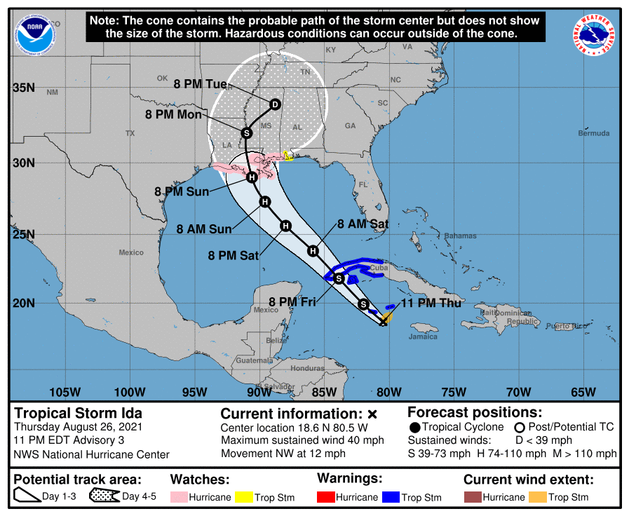
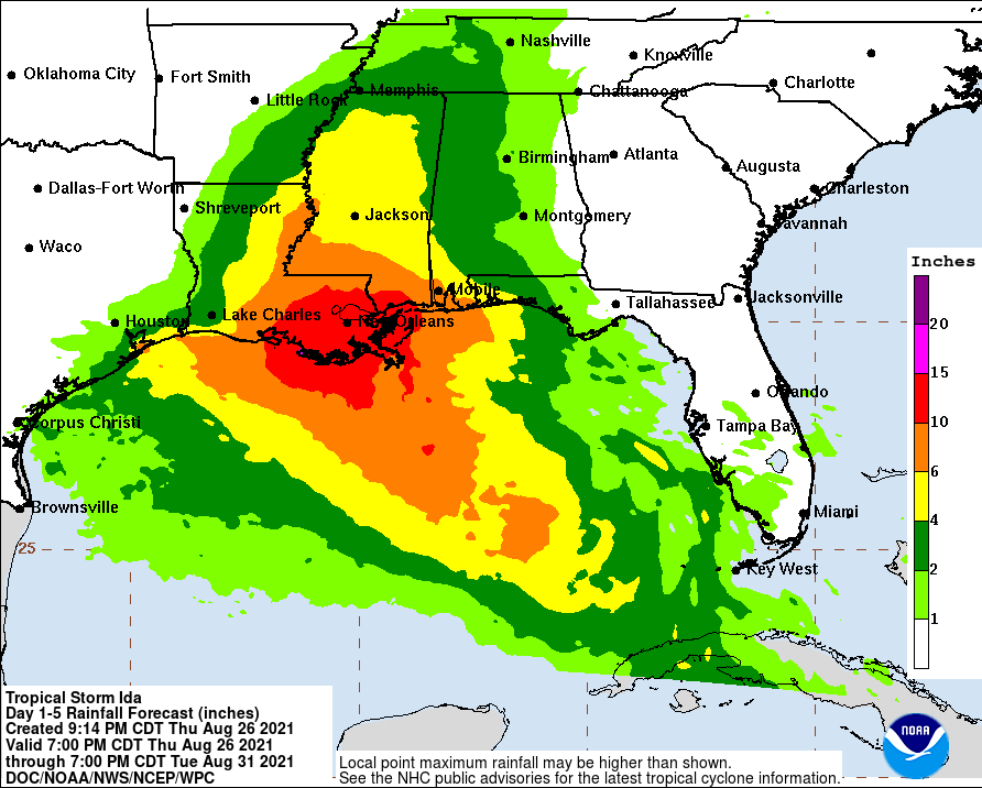
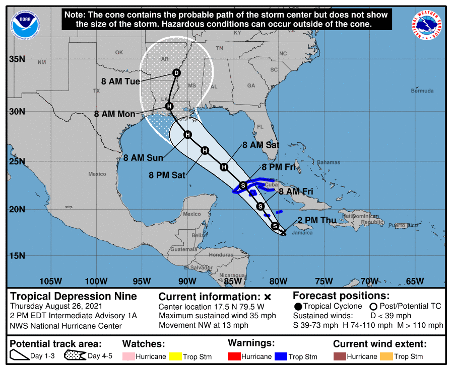
Posted about this elsewhere yesterday, as it was a tropical wave that the NHC felt had a high potential for becoming a tropical storm and then hurricane and unfortunately, they were right, as the wave has consolidated into a tropical depression and is expected to become TS Ida later today in the NW Caribbean. Conditions are favorable for significant strengthening once in the GOM, with very warm sea surface temps, light shear and moist conditions in the region.
As a result, Ida's forecast track has it becoming a Cat 1 hurricane as it enters the GOM, after likely going over the far western end of Cuba as a strong TS Friday night. The official forecast is for the storm to strike somewhere in Louisiana (New Orleans is clearly at risk here) as a strong Cat 2 hurricane (110 mph winds) very early Monday morning, although that's still 4 days out, so interests between the Texas coast and the Florida Panhandle need to be watching this.
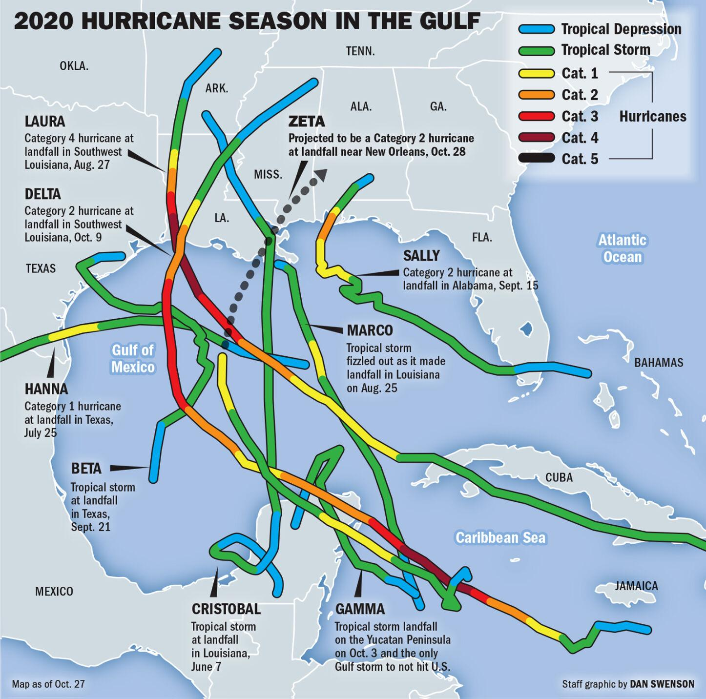
Track forecasts are usually much better than intensity forecasts (except for Henri, lol) and there is some risk of Ida becoming a very powerful hurricane (Cat 3/4) - it's nearly unprecedented for an initial NHC forecast to predict rapid intensification to near major hurricane status. After absorbing five landfalling systems (3 hurricanes and 2 TS's) last season, as per the graphic below, the LA coast does not need another hurricane hitting there.
This system could eventually impact our area as a remnant storm by mid/late next week - yes that could mean some impact for the Temple game, but way too early to predict that. Some of the usual links below.
https://www.nhc.noaa.gov/graphics_at4.shtml?start#contents
https://weather.com/safety/hurrican...on-nine-forecast-tropical-storm-hurricane-ida
https://www.americanwx.com/bb/topic/55251-tropical-depression-nine/page/5/
FORECAST POSITIONS AND MAX WINDS
INIT 26/1500Z 16.9N 79.2W 30 KT 35 MPH
12H 27/0000Z 18.2N 80.4W 35 KT 40 MPH
24H 27/1200Z 20.3N 82.0W 45 KT 50 MPH
36H 28/0000Z 22.5N 83.9W 55 KT 65 MPH...INLAND
48H 28/1200Z 24.4N 86.0W 65 KT 75 MPH...OVER WATER
60H 29/0000Z 26.1N 88.1W 80 KT 90 MPH
72H 29/1200Z 27.7N 90.0W 95 KT 110 MPH
96H 30/1200Z 30.5N 92.0W 70 KT 80 MPH...INLAND
120H 31/1200Z 33.7N 91.2W 30 KT 35 MPH...INLAND
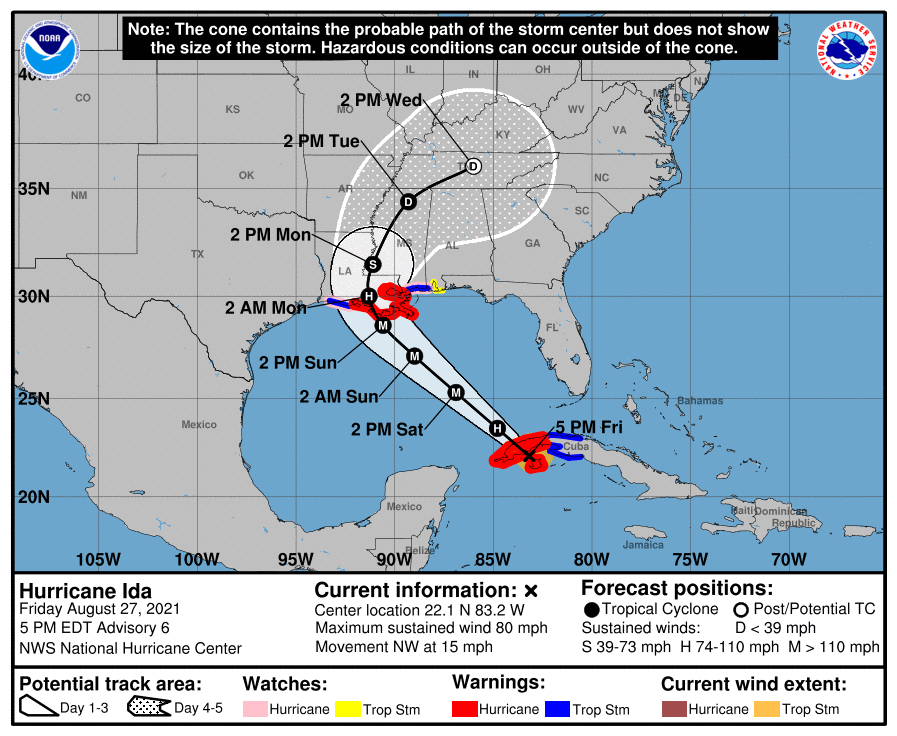
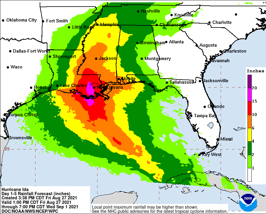
As a result, Ida's forecast track has it becoming a Cat 1 hurricane as it enters the GOM, after likely going over the far western end of Cuba as a strong TS Friday night. The official forecast is for the storm to strike somewhere in Louisiana (New Orleans is clearly at risk here) as a strong Cat 2 hurricane (110 mph winds) very early Monday morning, although that's still 4 days out, so interests between the Texas coast and the Florida Panhandle need to be watching this.
Track forecasts are usually much better than intensity forecasts (except for Henri, lol) and there is some risk of Ida becoming a very powerful hurricane (Cat 3/4) - it's nearly unprecedented for an initial NHC forecast to predict rapid intensification to near major hurricane status. After absorbing five landfalling systems (3 hurricanes and 2 TS's) last season, as per the graphic below, the LA coast does not need another hurricane hitting there.
This system could eventually impact our area as a remnant storm by mid/late next week - yes that could mean some impact for the Temple game, but way too early to predict that. Some of the usual links below.
https://www.nhc.noaa.gov/graphics_at4.shtml?start#contents
https://weather.com/safety/hurrican...on-nine-forecast-tropical-storm-hurricane-ida
https://www.americanwx.com/bb/topic/55251-tropical-depression-nine/page/5/
FORECAST POSITIONS AND MAX WINDS
INIT 26/1500Z 16.9N 79.2W 30 KT 35 MPH
12H 27/0000Z 18.2N 80.4W 35 KT 40 MPH
24H 27/1200Z 20.3N 82.0W 45 KT 50 MPH
36H 28/0000Z 22.5N 83.9W 55 KT 65 MPH...INLAND
48H 28/1200Z 24.4N 86.0W 65 KT 75 MPH...OVER WATER
60H 29/0000Z 26.1N 88.1W 80 KT 90 MPH
72H 29/1200Z 27.7N 90.0W 95 KT 110 MPH
96H 30/1200Z 30.5N 92.0W 70 KT 80 MPH...INLAND
120H 31/1200Z 33.7N 91.2W 30 KT 35 MPH...INLAND
Last edited: