Some interesting post-hurricane tidbits on Ida, which in the big picture was a forecast tour-de-force, with the track and intensity predictions being very close to actual conditions throughout the hurricane's journey. Probably the best summary of the storm and impacts, with a bunch of pictures and videos, is from the Washington Post in the link below.
https://www.washingtonpost.com/nation/2021/08/30/hurricane-ida-live-updates/
First off, a boat in Port Fourchon, where Ida first made landfall in SE Louisiana, recorded an official wind gust of 172 mph and a sustained wind of 149 mph, clearly verifying Ida's satellite and dropsonde measurements of 150 mph sustained winds at landfall. It's rare that recorded winds match those from satellites/dropsondes, mostly because there aren't that many high quality anemometers in the path of any landfalling hurricane (many weather stations have units that break before reaching 120 mph or more), plus winds over "regular" land lose a bit of punch from frictional effects, which is not the case in SE LA, where there's probably more water than land and zero elevation to speak of.
There were plenty of other gusts over 120 mph recorded, as per the tweet/graphic below. The damage to structures, trees, and the power grid (with over a million customers without power, including almost everyeon in New Orleans), mostly from Ida's winds was catastrophic throughout much of SE LA, as many have likely seen on TV or the internet.
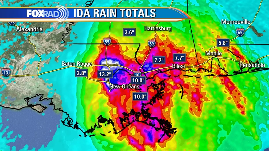
Secondly, the storm surge was catastrophic (6-12 feet) throughout SE LA, leading to inundation of many towns and destruction of many structures (couldn't find a graphic on surge). In addition, the amount of rainfall was torrential, as expected, with 8-15"+ amounts in large parts of SE LA and southern MS and 5-8" amounts everywhere else in southern LA and much of southern MS/AL; see the graphic below. Serious to catastrophic inland flooding from rainfall, combined with storm surge in some places occurred.
Having said all that, the levee systems in LA and especially New Orleans stood up remarkably well, keeping flooding in areas protected by levees to a minimum, unlike what happened in Katrina, particularly in NO, where over 1000 died as the levees were breached. So far, there are only 2 reported deaths in LA from Ida and even if that rises to a few dozen, as expected, that's far, far less than from Katrina, which is a testament to the improved levee/pumping systems (plus surge was higher in NO from Katrina, although a Katrina level surge would've likely not been an issue for Ida).
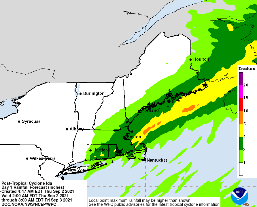
Lastly, the storm isn't over yet, as the remnants of Ida are pummeling much of MS/AL/TN right now, with our area in the crosshairs next, as 3-5" of rain are expected throughout most of the Philly-NJ-NYC region from Wednesday morning through Thursday morning, with some spots possibly getting 6-7", as per the graphic below and the NWS discussions. There could be significant urban and stream flooding given how wet this summer has been. Much more on this in the gameday weather thread...