How's the surf?
quite calm actually. It just started raining here and getting windy


Follow along with the video below to see how to install our site as a web app on your home screen.
Note: This feature may not be available in some browsers.
How's the surf?
quite calm actually. It just started raining here and getting windy
He seems to be calling for 1-2 inches for most of NJ.Dan Zarrow 101.5 blog
Please. All MVC offices closed too
See my post above, TORNADO Warning on your area til 10:15
They just said Tornado Warning for all of NJ.See my post above, TORNADO Warning on your area til 10:15
They just said Tornado Warning for all of NJ.
https://www.nj.com/weather/2020/08/...rts-of-nj-as-tropical-storm-isaias-nears.htmlNo, Tornado Watch for all of NJ
A warning on Cape May county as radar indicated rotation in the ocean heading towards Sea Isle City
That is correct. Don't see this very often. Doesn't mean we'll have more than a handful of actual tornadoes, but it means conditions make it possible for a small tornado to hit almost anywhere without much warning.No, Tornado Watch for all of NJ
A warning on Cape May county as radar indicated rotation in the ocean heading towards Sea Isle City
Had a similar experience at Rahway inspection station, in and out. To add to it, I was getting my old beater of less than a mile drive to the train station commuter car inspected, it rattles, sputters from the exhaust, everything, and it passed with flying colors. Rubber stamp approvals at their finest.Speaking of MVC. I went to the Rio Grande station to get my car inspected. No exaggeration, I was in and out in about 60 seconds. What are they even checking for these days? Can we just get rid of the entire inspection thing? Seems like a big waste of money that serves no purpose.
Yeah I know that, just wasn't paying attention to the letters after the "W"Yup
When a WARNING is issued. Either a funnel cloud is spotted or rotation is seen on the radar
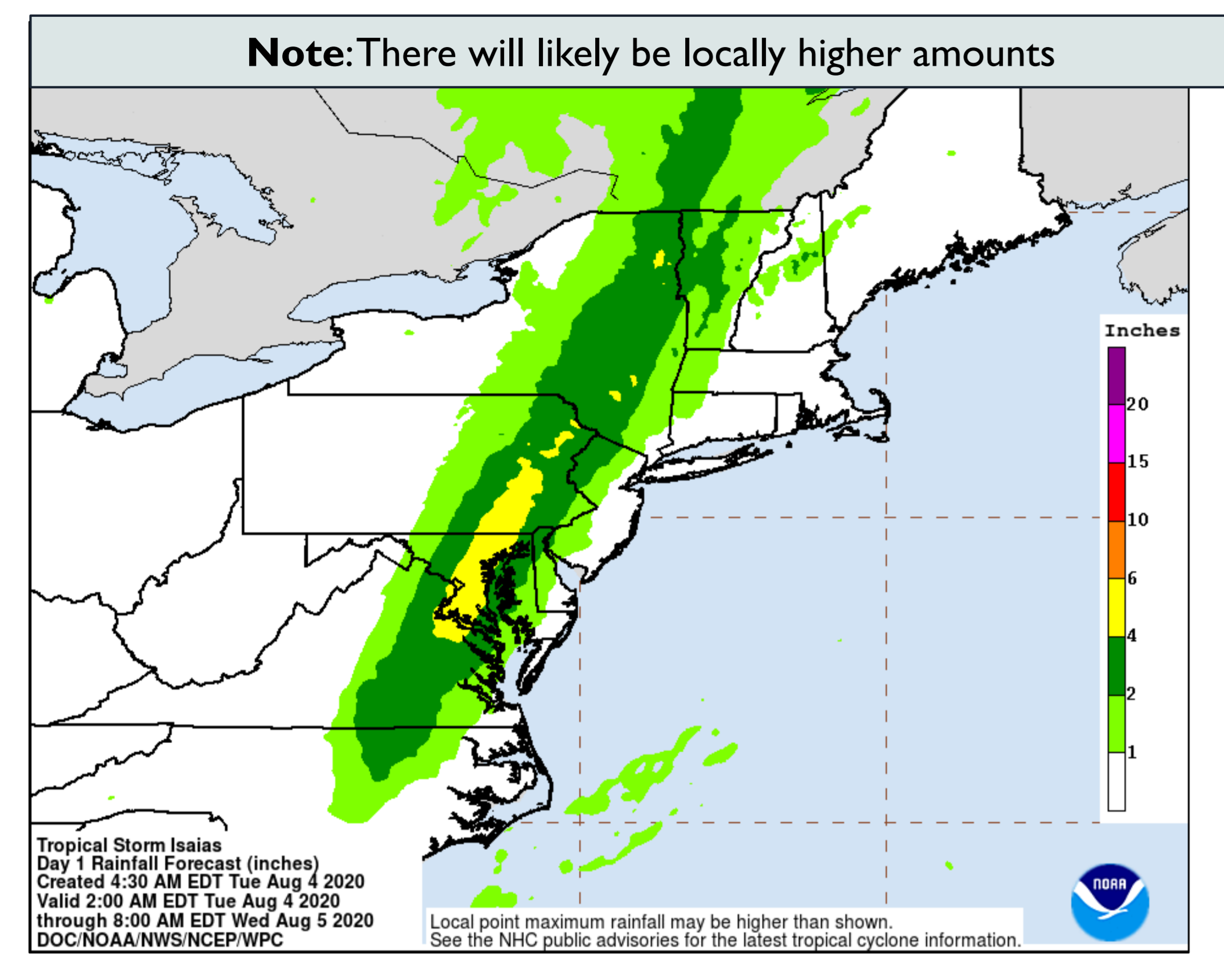

If that pans out, we're pretty lucky. I'll never forget all the rain with Irene and two big nor'easters in 2007 and 2010.He seems to be calling for 1-2 inches for most of NJ.
Looking at Doppler and the track of this storm, it looks like Middlesex and Monmouth (eastern side of the state) might escape the worst of this storm, it seems to be shooting straight north.
If that pans out, we're pretty lucky. I'll never forget all the rain with Irene and two big nor'easters in 2007 and 2010.
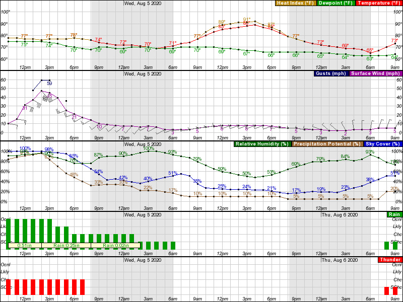
Yeah in the last 10 mins the winds in Sayreville (not far from you) have picked up.Yes, with regard to heavy rains, but winds are seriously picking up in SNJ and are about to get pretty bad up here soon. The graphic below is for the Edison area, with the worst winds from about 1 pm to 4 pm.
I got a lot of water with all that I mentioned. Got battery back up for the sump pump since that time. I would have been fine with Irene had I had that.Yes, Irene was a bad one . I had about a half foot of water in my basement to prove it !
Irene gets lost in the shuffle because sandy hit 15 months later .
Wow, are you down there in eastern NC somewhere? Good luck man.
A case of the haves and have nots..wouldnt be surprised to see sun after 1 PM
I'm in PA Montgomery county, near Lansdale/West Point and we are drowning. Local roads were already flooded this morning with storm drain backups and retention pond overflows. Low winds thus far just a steady heavy straight downpour. Been in my house 5yrs and basement wet first time.
New tornado warning in Ocean/Southern Monmouth...
Tornado Warning
NJC025-029-041530-
/O.NEW.KPHI.TO.W.0028.200804T1500Z-200804T1530Z/
BULLETIN - EAS ACTIVATION REQUESTED
Tornado Warning
National Weather Service Mount Holly NJ
1100 AM EDT Tue Aug 4 2020
The National Weather Service in Mount Holly NJ has issued a
* Tornado Warning for...
Ocean County in southern New Jersey...
Southern Monmouth County in central New Jersey...
* Until 1130 AM EDT.
* At 1059 AM EDT, a confirmed tornado was located over Barnegat, or
17 miles south of Toms River, moving north at 55 mph.
HAZARD...Damaging tornado.
SOURCE...Weather spotters confirmed tornado.
IMPACT...Flying debris will be dangerous to those caught without
shelter. Mobile homes will be damaged or destroyed.
Damage to roofs, windows, and vehicles will occur. Tree
damage is likely.
* Locations impacted include...
Toms River, Lakewood, Jackson, Barnegat, Beachwood, Lakehurst,
Leisure Village, Holiday City South, Pleasant Plains, Cedar Glen
West, Leisure Village East, Cassville, Woodruff, Holiday
City-Berkeley, Bamber Lake, Cedar Glen Lakes, Whiting, Brookville,
Pine Ridge At Crestwood and Beach Haven West.
This includes Garden State Parkway between mile markers 61 and 90.
PRECAUTIONARY/PREPAREDNESS ACTIONS...
Protecting yourself from immediate threats to life and safety shall
take priority. Whenever possible, as long as it does not cause
greater harm, all COVID-19 protective action guidance should be
followed.
To repeat, a tornado has been confirmed. TAKE COVER NOW! Move to a
basement or an interior room on the lowest floor of a sturdy
building. Avoid windows. If you are outdoors, in a mobile home, or in
a vehicle, move to the closest substantial shelter and protect
yourself from flying debris.
I am in Chester county(west Chester area), and it has been pouring here since about 8am(and maybe some overnight). Big rivers of water flowing down the yard. Retention basin behind us is up to the overflow.I'm in PA Montgomery county, near Lansdale/West Point and we are drowning. Local roads were already flooded this morning with storm drain backups and retention pond overflows. Low winds thus far just a steady heavy straight downpour. Been in my house 5yrs and basement wet first time.

