Hit 91 yesterday to make the 6th day of the heatwave for me. Some other parts of the state fell short of 90 so their heatwave is over. One more day possible for 90 or a bit above and then a cold front sweeps through with a period of showers and thunderstorms probable tomorrow...timing looks like anywhere from mid morning to mid afternoon.


Colleges
- AAC
- ACC
- Big 12
- Big East
- Big Ten
- Pac-12
- SEC
- Atlantic 10
- Conference USA
- Independents
- Junior College
- Mountain West
- Sun Belt
- MAC
- More
- Navy
- UAB
- Tulsa
- UTSA
- Charlotte
- Florida Atlantic
- Temple
- Rice
- East Carolina
- USF
- SMU
- North Texas
- Tulane
- Memphis
- Miami
- Louisville
- Virginia
- Syracuse
- Wake Forest
- Duke
- Boston College
- Virginia Tech
- Georgia Tech
- Pittsburgh
- North Carolina
- North Carolina State
- Clemson
- Florida State
- Cincinnati
- BYU
- Houston
- Iowa State
- Kansas State
- Kansas
- Texas
- Oklahoma State
- TCU
- Texas Tech
- Baylor
- Oklahoma
- UCF
- West Virginia
- Wisconsin
- Penn State
- Ohio State
- Purdue
- Minnesota
- Iowa
- Nebraska
- Illinois
- Indiana
- Rutgers
- Michigan State
- Maryland
- Michigan
- Northwestern
- Arizona State
- Oregon State
- UCLA
- Colorado
- Stanford
- Oregon
- Arizona
- California
- Washington
- USC
- Utah
- Washington State
- Texas A&M
- Auburn
- Mississippi State
- Kentucky
- South Carolina
- Arkansas
- Florida
- Missouri
- Ole Miss
- Alabama
- LSU
- Georgia
- Vanderbilt
- Tennessee
- Louisiana Tech
- New Mexico State
- Middle Tennessee
- Western Kentucky
- UTEP
- Florida International University
High School
- West
- Midwest
- Northeast
- Southeast
- Other
- Alaska
- Arizona
- California
- Colorado
- Nevada
- New Mexico
- Northern California
- Oregon
- Southern California Preps
- Washington
- Edgy Tim
- Indiana
- Kansas
- Nebraska
- Iowa
- Michigan
- Minnesota
- Missouri
- Oklahoma Varsity
- Texas Basketball
- Texas
- Wisconsin
- Delaware
- Maryland
- New Jersey Basketball
- New Jersey
- New York City Basketball
- Ohio
- Pennsylvania
- Greater Cincinnati
- Virginia
- West Virginia Preps
ADVERTISEMENT
Install the app
How to install the app on iOS
Follow along with the video below to see how to install our site as a web app on your home screen.
Note: This feature may not be available in some browsers.
You are using an out of date browser. It may not display this or other websites correctly.
You should upgrade or use an alternative browser.
You should upgrade or use an alternative browser.
OT: LONG DURATION MAJOR HEATWAVE BEGINS FRIDAY JUNE 29
- Thread starter bac2therac
- Start date
Was absolutely beautful at Monmouth Park yesterday. Strong ocean breeze, set up under the trees in the shade guessing mid 80s tops. Very comfortable.Hit 91 yesterday to make the 6th day of the heatwave for me. Some other parts of the state fell short of 90 so their heatwave is over. One more day possible for 90 or a bit above and then a cold front sweeps through with a period of showers and thunderstorms probable tomorrow...timing looks like anywhere from mid morning to mid afternoon.
You sure? Is that by your own measurement or by an official one?Hit 91 yesterday to make the 6th day of the heatwave for me. Some other parts of the state fell short of 90 so their heatwave is over. One more day possible for 90 or a bit above and then a cold front sweeps through with a period of showers and thunderstorms probable tomorrow...timing looks like anywhere from mid morning to mid afternoon.
I am starting to thing that @RU848789 and his snow measurements is this guy

And you are this guy:
I don't think it broke 85 here in Wall. But still very humid--went through 4-6 athletic shirts moving mulch for 3-4 hours yesterday. Probably drank 2 gallons of water.
Over 90 once again today in Bergen County. Worse yet, the dew point is once again over 70 for I believe the 7th straight day. I remember stretches of this level of heat in the past, but not without at times at least some let up in the humidity.
Folks closer to the shore may be a few degrees cooler.
Folks closer to the shore may be a few degrees cooler.
You sure? Is that by your own measurement or by an official one?
I am starting to thing that @RU848789 and his snow measurements is this guy
And you are this guy:
I don't think it broke 85 here in Wall. But still very humid--went through 4-6 athletic shirts moving mulch for 3-4 hours yesterday. Probably drank 2 gallons of water.
Official measurement...92 today thus far today making it 7 days in a row for me

Cool. :sunglasses:Official measurement...92 today thus far today making it 7 days in a row for me
Same here. Tomorrow is the deluge, then it should be pretty nice by the late afternoon and through the weekend - best weekend in a long time with temps in the low/mid 80s, mostly sunny skies, comfortable humidity and no chance of rain.Official measurement...92 today thus far today making it 7 days in a row for me
Well, if you go before 4 pm, you're almost certainly going to see some heavy rain (1-2" likely from about 8 am to 4 pm), as these will be widespread heavy showers, not "scattered" showers, but it'll start to improve by late afternoon and you should even see some sun and much lower humidity by 6-7 pm - should be a gorgeous evening.I'm going to the asbury park biergarten tomorrow, I don't want heavy rain
Hi numbers-- I thought your favorite weather person Amy Freeze indicated in tonight's forecast that there would not be as much rain further south. Where is a good website to check out a local forecast? Specifically want to know what it will be like in the south part of Wall/Manasquan.Well, if you go before 4 pm, you're almost certainly going to see some heavy rain (1-2" likely from about 8 am to 4 pm), as these will be widespread heavy showers, not "scattered" showers, but it'll start to improve by late afternoon and you should even see some sun and much lower humidity by 6-7 pm - should be a gorgeous evening.
Hi numbers-- I thought your favorite weather person Amy Freeze indicated in tonight's forecast that there would not be as much rain further south. Where is a good website to check out a local forecast? Specifically want to know what it will be like in the south part of Wall/Manasquan.
I will need a transcript for what she said exactly, I dont want Numbers to start calling her out unfairly
I will need a transcript for what she said exactly, I dont want Numbers to start calling her out unfairly
I've never called her out unfairly, IMO, although I've criticized her as not being nearly as good as her peers (e.g., Lee Goldberg and Jeff Smith) at explaining complex meteorological events, since she does not have a degree in meteorology (and they do). I don't think that comparison is unfair and I've at least been consistent in it, calling out others who are similarly "challenged" since they don't have degrees (like Mike Woods, Sam Champion and Lonnie Quinn, all of whom are even worse than Amy, IMO). Others may disagree.
How about an answer to my question.I've never called her out unfairly, IMO, although I've criticized her as not being nearly as good as her peers (e.g., Lee Goldberg and Jeff Smith) at explaining complex meteorological events, since she does not have a degree in meteorology (and they do). I don't think that comparison is unfair and I've at least been consistent in it, calling out others who are similarly "challenged" since they don't have degrees (like Mike Woods, Sam Champion and Lonnie Quinn, all of whom are even worse than Amy, IMO). Others may disagree.
BTW, Mike Woods is recovering from prostate cancer surgery.
Hi numbers-- I thought your favorite weather person Amy Freeze indicated in tonight's forecast that there would not be as much rain further south. Where is a good website to check out a local forecast? Specifically want to know what it will be like in the south part of Wall/Manasquan.
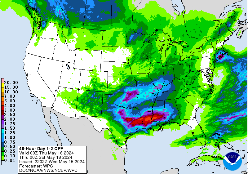
I don't watch Amy and I don't pay that much attention to the weather in the summer, but it only takes a few minutes to look at the forecast when asked, so here you go. The NWS, at least, isn't differentiating much across the Philly to NYC region, with just about everywhere having a forecast of at least 0.75" to as much as 1.5" (and even up to 2" in spots), with that rain falling generally between about 6 am and 4 pm for you, as per the graphic below. I like their graphical forecast format. All you ever need to do is click on the NWS map at your location, then click on the "hourly weather forecast" graphic on the lower right of the local forecast page. However, the HPC (hydrogmeteorological prediction center, i.e., the precip folks, are calling for a bit more towards the shore, as per the 2nd map.
https://www.weather.gov/phi/
How about an answer to my question.
BTW, Mike Woods is recovering from prostate cancer surgery.
Lucky for you I didn't see this post while I was spending much of the last half hour researching and writing up the forecast for you. And what's your point in bringing up Mike Woods's personal health situation?
Well, if you go before 4 pm, you're almost certainly going to see some heavy rain (1-2" likely from about 8 am to 4 pm), as these will be widespread heavy showers, not "scattered" showers, but it'll start to improve by late afternoon and you should even see some sun and much lower humidity by 6-7 pm - should be a gorgeous evening.
Sussex is supposed to miss out on the storms I heard
I'm leaving for AP around 10
What do you mean? Why do you bother replying to bac's posts, when he is clearly trying to trigger you. That's not what I was doing. I watch channel 7 news in the evening, an Amy happened to the meteorologist giving the forecast.Lucky for you I didn't see this post while I was spending much of the last half hour researching and writing up the forecast for you. And what's your point in bringing up Mike Woods's personal health situation?
And regarding Mike Woods- because you mentioned him in your post above? Thought you might like to know.
Thanks for pointing out the hour by hour forecast map. I usually don't venture over to the NWS sight, and did not realize they gave such detailed graphics for summer weather. Thanks.
We all right?
Too funny.What do you mean? Why do you bother replying to bac's posts, when he is clearly trying to trigger you. That's not what I was doing. I watch channel 7 news in the evening, an Amy happened to the meteorologist giving the forecast.
And regarding Mike Woods- because you mentioned him in your post above? Thought you might like to know.
Thanks for pointing out the hour by hour forecast map. I usually don't venture over to the NWS sight, and did not realize they gave such detailed graphics for summer weather. Thanks.
We all right?
You will be heading straight into the storm. Why not wait?Sussex is supposed to miss out on the storms I heard
I'm leaving for AP around 10
If you want a place to kill time in the rain:
Silverball Museum on the Boardwalk
Loteria has good cheap eats.
You will be heading straight into the storm. Why not wait?
If you want a place to kill time in the rain:
Silverball Museum on the Boardwalk
Loteria has good cheap eats.
I called my bud and we may push this to Saturday, though I'll see tomorrow
Rain will keep crowds down.I called my bud and we may push this to Saturday, though I'll see tomorrow
Fridays are better than Saturdays.
Seemed like you were being snarky ("how about an answer to my question?") while I was slaving away on your forecast, so I gave a little back. No big deal, just goofing around. Good luck with the weather in Wall tomorrow.What do you mean? Why do you bother replying to bac's posts, when he is clearly trying to trigger you. That's not what I was doing. I watch channel 7 news in the evening, an Amy happened to the meteorologist giving the forecast.
And regarding Mike Woods- because you mentioned him in your post above? Thought you might like to know.
Thanks for pointing out the hour by hour forecast map. I usually don't venture over to the NWS sight, and did not realize they gave such detailed graphics for summer weather. Thanks.
We all right?
And I've largely been ignoring the troll posts for quite awhile, but I just felt like answering that one in case others might be interested in my perspective on that topic. In case you hadn't noticed, I kind of like arguing sometimes...
Sussex is supposed to miss out on the storms I heard
I'm leaving for AP around 10
Sussex is not supposed to miss out on the storms, although the intensity and rainfall amounts up there are supposed to be a bit less than towards I-95 and the coast. The storms in Sussex are likely to be at their worst in the morning vs. early/mid afternoon in AP. This is not an all day washout, but most areas will likely see a few hours of occasional showers, with some of the rain being very heavy and some urban and small stream flooding being possible (hence the flood watch for most).
Some storms came through a bit earlier...another line back out in PA will come through later. No big deal really..we had garden variety boom booms this morning that dropped .66 Imby
yes seemed like the storms slowed down as they passed through west central NJ and those to the east are getting hit harder. Pleasantly surprised that this came in earlier so I can go to work
All calm in the 52nd. Heavy rain and a little thunder, but nothing major here in Wall.Much more significant down here. Steady moderate to heavy rain since before 0500, frequent lightning. So far 32-1 and 16-2 with the lightning strike / structure fires.
Were you face down in a puddle? :stuck_out_tongue_winking_eye: Or did you borrow #'s snow gauge?The parting shot - about 15 minutes worth of heavy rain and near-continuous thunder - dropped just over an inch on me, per the World's Best Rain Gauge.
Were you face down in a puddle? :stuck_out_tongue_winking_eye: Or did you borrow #'s snow gauge?
I use the pool. More specifically, the pattern on the liner. It's now about 1/2" from the point where I have to open up the blow-off and start pumping water into the creek.
We got less than a quarter inch up here overnight.
Totally mispredicted storm
I think I just got a quarter inch in the last 15 mins. here in Howell. It's really coming down and a chorus of thunder and lightning show too boot.We got less than a quarter inch up here overnight.
First batch mostly missed everyone north of 78 (except N of 78 and east of about the Parkway through NYC, which did get hit with some rain), which is a surprise, but that's not very unusual with mesoscale convective events like this. They hammered points from 276/195 and south of there where flash flood warnings are now up, as 1-2" were common and 3-4" came down in spots. One more round to come with the front late this morning through early/mid afternoon, but probably <1/2" for most with this batch, although some areas could, again, get an inch or more. Will start improving by 2-3 pm for most.
National Weather Service Mount Holly NJ
1038 AM EDT Fri Jul 6 2018
NEAR TERM /UNTIL 6 PM THIS EVENING/...
An initial batch of showers and thunderstorms with heavy rain
moved across southeastern Pennsylvania and central and southern
New Jersey early this morning. Rainfall totals of 1 to 2 inches
were common in that area with some spots receiving 3 to 4
inches. That area of showers and thunderstorms had moved off the
coast by 10:30 AM. Meanwhile, showers and thunderstorms
lingered in southern Delaware.
Additional showers and scattered thunderstorms associated with
a pre-frontal trough extending from western New England to
central Pennsylvania will continue to strengthen as they move
eastward.
The pre-frontal showers and thunderstorms are forecast to
progress through eastern Pennsylvania and northern New Jersey by
early afternoon. The back edge of the precipitation is
anticipated to reach southern Delaware and far southern New
Jersey before 6:00 PM.
The potential for locally heavy rainfall persists. As a result,
the Flash Flood Watch remains in effect until 2:00 PM.
Good call on the first one, but next week is not looking like much of a heat wave. It's looking a little bit warmer than normal, i.e., normal highs are about 86F and highs next week will be generally between 85-90F, with 1-2 days probably topping 90F. Personally, I think "heat waves" need to be more than 4-5F above normal, i.e., 90F shouldn't be called a heat wave in July. Just like 4 days in a row with lows in the upper teens in January doesn't feel like much of a cold wave to me. This past week was a real heat wave with temps in the 95F range for 4 days in a row and over 90F for 6 or 7 days depending on one's location.Another heatwave coming next week..details yet to be ironed out
We shall see...models have been vascillating on whether we get 85-90 or 90-95...3 days of 90 or above consecutively is a heatwave whether you disagree or not. It may be a case of delayed but not denied heatwave just pushed back until next weekend and beyond
Looks to commence Friday but possibly Thursday for some and run at least through the 4th of July. Question is how hot will it get. Right now as they usual do mets and NWS are being cautious with low to some mid 90s forecast but models such as the GFS are quite brutal spitting out number as high as 107, even if wrong there is a possibility of approaching 100 in some hot spots at some point Sunday or early next week. the 12z GFS cut back on those extreme numbers but there were still outputs near or above 100.
So get ready everyone, make sure your fans and ACs and thermostats are working. A heat lovers paradise coming like manna from heaven.
It was 108 yesterday here in Cypress CA (next to Long Beach). Heat warmings were out for several counties...but Death Valley recorded 120!
MO
It was 108 yesterday here in Cypress CA (next to Long Beach). Heat warmings were out for several counties...but Death Valley recorded 120!
MO
Just noticed I misspelled "warnings"...and wrote "warmings".
Apropos Malaprop!
MO
Similar threads
- Replies
- 608
- Views
- 17K
- Replies
- 592
- Views
- 15K
- Replies
- 771
- Views
- 20K
ADVERTISEMENT
Latest posts
-
 ***WAR ROOM: Latest Recruit Scoop and Team News on Rutgers Athletics***
- Latest: -RUFAN4LIFE-
-
-
ADVERTISEMENT