Bumping since the quoted post has all the 12Z model runs and...
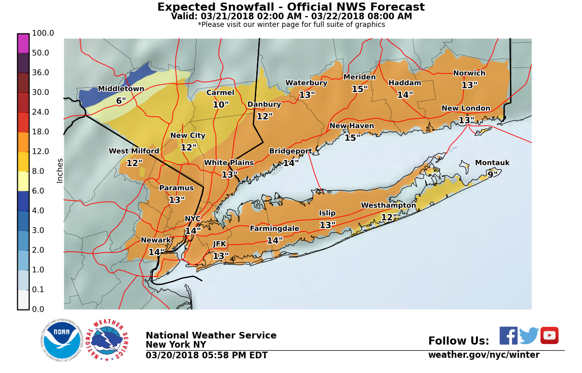
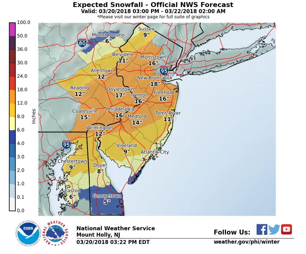
Well, it's pretty clear to me that we've seen a small to modest downward trend in almost all of the models runs tonight, especially for CNJ/SNJ/Philly (not as much for NNJ/NYC). While the pros always say not to look at snowfall maps too much, I'm not expert enough to analyze upper air maps and trends and figure out what's going on, but I am pretty good at pattern recognition and nearly every 00Z model - Euro GFS, UK, CMC, RDPS (RGEM), and HRPDS (high res RPDS) - showed a modest to occasionally significant decrease in snowfall vs. 18Z or 12Z. Only the NAM 12 km and 3 km looked similar, at least for CNJ/NNJ/NYC. In fact the Euro showed a 30-40% reduction in snowfall for most; from 10-16" to 6-10". Ouch. But earthlight a brilliant pro on 33andrain said its solution made no sense and to toss it.
On 33andrain I posted about this and asked if it's truly meaningful. I think it is and others have been saying it is, but nobody has really addressed my question yet. I mostly am wondering if this will be the extent of the reduction or might we be facing more. At some point, if we don't get near the 1-2" per hour rates being advertised for 2 days now, we're going to see some white rain, even with better surface temps than the previous nor-easters and that will reduce accumulations even more (and if we don't get as good a level of crystal growth, we also might not reach 10:1 as I was hoping, given good column thermal profiles). Don't get me wrong - getting 6-10" in March would still be pretty impactful - but not nearly as impactful as the 12-18" NWS forecast.
So, what happens now? Even if we discount the Euro, the other model reductions are at least modest, so I expect forecast reductions to come from the NWS in a couple of hours. I'm guessing they'll drop back to 10-15" for CNJ, NNJ, NYC and LI, but drop further for E PA, Philly/SNJ (maybe to 6-10"), if they don't lean too heavily on the Euro, as 10-14" is defensible from the other models. The funny thing is that would be in line with what I said earlier today, when they upped their totals to 12-18" this afternoon: "I think the NWS is being a little too aggressive with snowfall totals, by a few inches. I’m “only” predicting 12” for my house in Metuchen." I think what they had, around 10-15" was a better call - I would've waited to see 00Z models tonight before jumping to 12-18". Well, we'll see pretty soon what happens. Also, 10-14" is in line with what Lee Goldberg and Nick Gregory, two of the most respected NYC mets were predicting for most of the CNJ/NNJ/NYC/LI area (with less towards Philly and the Shore).
Edit - forgot to post last night's 00Z Euro...