ADVERTISEMENT

OT: Potential Winter Storm on 3/7-8

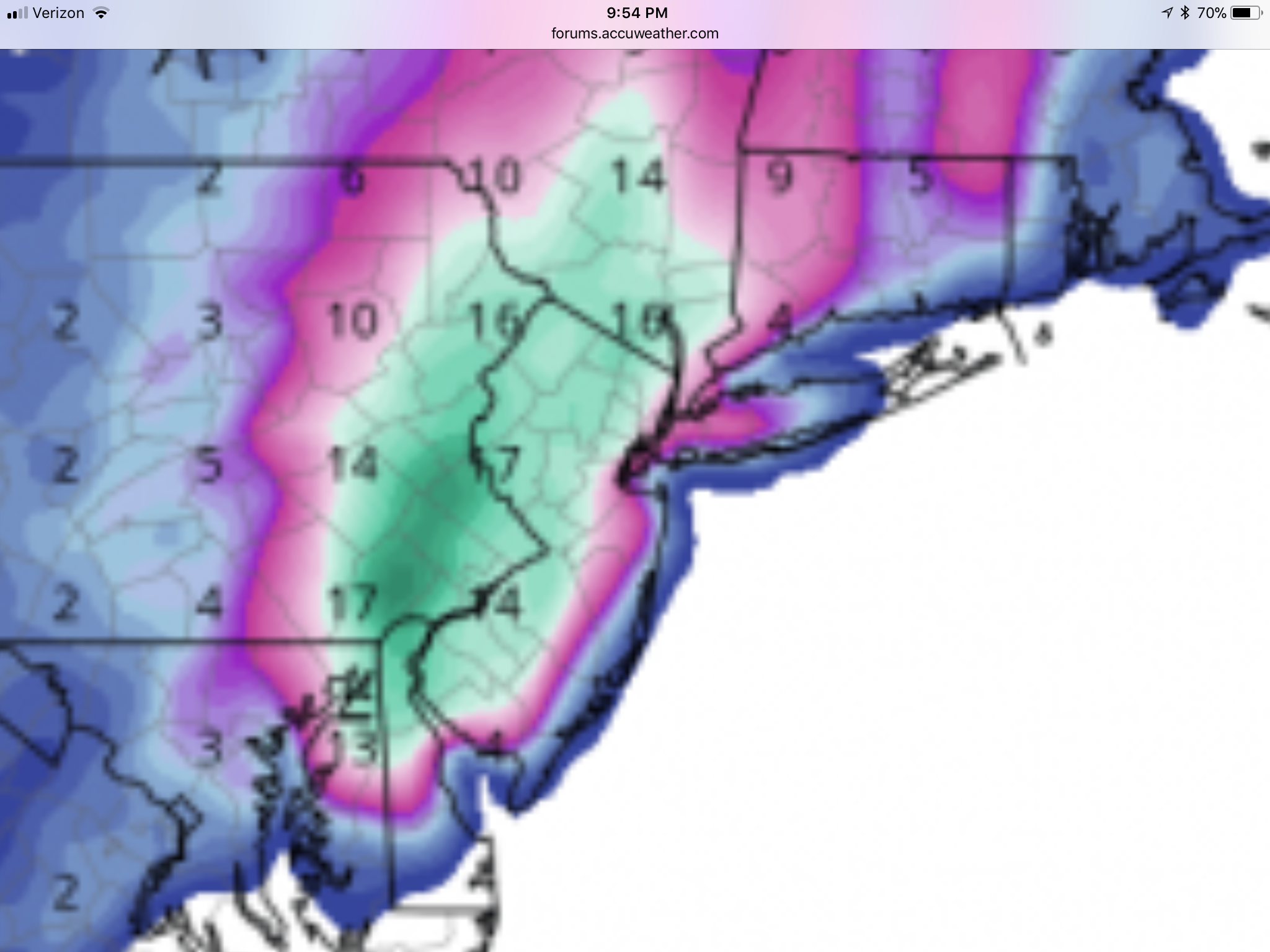
New NAM dominates NJ with foot plus for most. I don’t follow these threads to much because the back and forth is too much to sift threw, so not sure what is generally discussed about the models, but I have found the NAM to be pretty darn good with these explosive winter storms over the last 2 years. Def much better then GFS

OQZ6Pz5.png
 
It can snow as much as #s desires but as long as there is no wind like Friday. Just got my power back. Had nothing to do with snow.
Having lived through Sandy and a week without power, experience helps so this was easier. Especially the technology. No TV, no problem, never missed news or sports with a tablet I could charge with my car.
 
  • Like
Reactions: DennisHajekRC84
It can snow as much as #s desires but as long as there is no wind like Friday. Just got my power back. Had nothing to do with snow.
Having lived through Sandy and a week without power, experience helps so this was easier. Especially the technology. No TV, no problem, never missed news or sports with a tablet I could charge with my car.

Well, there will be some wind, but not like Friday, but enough to possibly cause some more power outages if we get a major snowfall of fairly wet snow that sticks to trees. Sometimes just having enough snow on the trees is enough, even without wind. The Oct 2011 storm was like that - not much wind, but heavy wet snow bringing down branches and trees. What you want is a dry enough snow and some wind, so that the snow doesn't accumulate much on the trees. Having also lived through a week without power during Sandy, I hear ya. Places n NWNJ/Poconos/Catskills etc. are still without power.
 
New NAM dominates NJ with foot plus for most. I don’t follow these threads to much because the back and forth is too much to sift threw, so not sure what is generally discussed about the models, but I have found the NAM to be pretty darn good with these explosive winter storms over the last 2 years. Def much better then GFS

OQZ6Pz5.png

If you follow this stuff enough, most of the very good pros never go all in on one model and tend to rely on model "blends" of 2 or 3 models for temps and maybe 2 other models for precip, based on their knowledge of the setup and the known biases of the models. The NAM is known for being good with dynamic systems with heavy convective precip, as it's a mesoscale, high resolution (more 3D grid points than the global models) model, but it is also prone to significantly over-predicting precip at times. And its accuracy at the end of its 84 hour range is usually iffy, but now where within 60 hours of the start, so it's getting closer to when it gets used more.

I've always been torn on posting model output, as I don't think most people on this board will really know all the caveats and limitations of the models, whereas most of the posters on the weather boards, even the wishcasting weenies, have a pretty good working knowledge of meteorology and won't get confused by them. When I do post them I try to provide some context and tell people they're NOT forecasts and are prone to some large errors at times. The worst, though is seeing huge, unrealistic snowfall maps posted on social media by people just looking to hype.

Anyway, the GFS and RGEM are both also quite snowy, like the NAM, while the CMC is no longer a complete miss to the SE, but is just a glancing blow with only an inch or maybe 2 for 95 and a bit more at the Shore (much closer to the rest of the models now). If the Euro shows a decent to big hit, we might see winter storm watches with the NWS 4 am package, as that's 48 hours before the storm, when they often start issuing watches.
 
Actually, this year's forecasts from most sources have been especially good, except for Friday, IMO. What's a wishcater? Is that like a genie?

Haha I'm just a grumpy snow hater as I got older. Snowboarded out in Wyoming & Colorado most of my 20's & 30's until I ripped up my knee and messed up the back. I do appreciate the info here you provide & it's better than any local news the wife watches !
Had a flight Friday to Vegas and moved it to 6:30am just to get outta Newark and was grateful for no delays
 
  • Like
Reactions: RU848789
So, here's what I just sent out to my work subscriber list and my friends and family email list - it kind of summarizes where we are all in one place. Enjoy...

Summary: So, we now have a pretty strong consensus for a moderate (2-4”) to significant (4-8”) and possibly major (8-14”) snowstorm impacting our area from before sunrise on Wednesday into Weds night. Four of the 6 global/mesoscale models are showing a general 8-12” (and even up to 18” in 1-2 models) snowstorm for Philly to NYC and points NW of that line and a rain to snow scenario for the coast with possibly only a few to several inches of snow there. But the Euro (stilll the best model) is showing a 2-4” event for the 95 corridor and 4-8” towards the Shore and on LI and the CMC is showing a bit less than that even, but that is usually the worst scoring global. We’re still 60 hours from the event, so it’s still possible to get more rain than snow along 95, if the track moves NW and it’s still possible to get all snow everywhere and it’s still possible to get a light to moderate event from 95 to the coast, with little N/W, if the storm goes further SE. But an all rain inland track and a complete miss out-to-sea track are just about off the table. Today's NWS maps below.

Details: As I described in last night’s update, this is a very different storm from Friday’s. This storm has much more model support and pattern support for snow in the 95 corridor and coast than Friday's did - Friday's was a more powerful and much longer lasting storm (with 2-3 feet of snow for locations in far NW areas that got all snow), but for our area, it relied on perfect dynamics to get some late snow in some places south of 78 that got those dynamics. This storm also won’t have anywhere near the coastal flooding/high winds that Friday’s had.

Getting back to snow, the antecedent air in place will be colder than Friday and there won't also be 1-2" of rain beforehand, both of which greatly increased melting rates vs. what we'll have on Wednesday - although there will still likely be a ~1/4" per hour melting rate on Wednesday vs. the 3/8-1/2" estimated melting rate we had on Friday. In addition, more than half of the precip should fall after 4 pm, meaning the effect of the indirect sunlight will be minimal.

The biggest key is probably this: if one gets a snowfall intensity for an hour or so that overcomes the melting rate (like 2/17 and Friday in places with very high intensity snowfall), then a layer of snow becomes established on the ground, which then means subsequent snowfall accumulates easily, since the snow is 32F, which means no melting from the air temps, plus snow reflects 80-90% of the indirect sunlight (as opposed to grass which only reflects 25% of sunlight and asphalt, which only reflects 5% of sunlight), so much less melting from the surface. And as per most of the models, we expect to get moderate (1/2”/hr) to heavy (1” or more per hour rates) snowfall throughout much of Wednesday, which would be well in excess of the worst melting rate; if we get only light to moderate snowfall, like the Euro/CMC, much of the falling snow will likely melt.

The NWS posted snowfall maps for moderate snowfall earlier today, when there was less model consensus on a potential major snowstorm, so their maps of a general 3-5” level event reflect that. However, with the 18Z and most recent 00Z model runs (7 pm EST data input) showing a pretty strong consensus on at least a significant snowfall for most, I would expect to see those snowfall predictions increase to more like 4-8” and to also see them possibly issuing winter storm watches with the NWS 4 am package, as that's 48 hours before the storm, when they often start issuing watches; could also see them wanting to see one more model suite at 12Z tomorrow before pulling that trigger.

With regard to other effects, there will be some wind, perhaps enough to get close to blizzard conditions (frequent 35 mph gusts), especially near the coast, but not like Friday’s winds; same for coastal flooding – could be minor with this event, at most. And while the wind, alone, won’t be enough for power outages, in some places we could have more power outages if we get a major snowfall of fairly wet snow that sticks to trees. Sometimes just having enough snow on the trees is enough, even without wind. The Oct 2011 storm was like that - not much wind, but heavy wet snow bringing down branches and trees. What you want is a dry enough snow and some wind, so that the snow doesn't accumulate much on the trees.

Finally, there is at least one more chance of a winter storm for next Sunday/Monday, 3/11-12. The pattern we’re in with the –NAO (Greenland blocking high) is very conducive to fairly cold and potentially snowy weather. Way far out to forecast for, but worth watching.


28685107_10213379502436062_8456996893103226880_n.jpg


28577846_10213379505516139_2222474335333908480_n.jpg
 
Haha I'm just a grumpy snow hater as I got older. Snowboarded out in Wyoming & Colorado most of my 20's & 30's until I ripped up my knee and messed up the back. I do appreciate the info here you provide & it's better than any local news the wife watches !
Had a flight Friday to Vegas and moved it to 6:30am just to get outta Newark and was grateful for no delays
Been a snow nut since I was a toddler. Parents gave me the basic weather instruments as a kid, so I kept weather records for years, but only in winter. Came close to majoring in meteorology, but figured chem eng'g would pay better (it does on average). Used to ski a lot, including many years out in Tahoe, but not much the past few years - intend to correct that after retirement. Luckily never got hurt on the slopes, despite some hellacious spills. Thanks for the props!
 
  • Like
Reactions: MulletCork
Mount Holly lowered snow total in the 3:22 a..m maps for at least the Shore/Coast. Seems to have pushed NW towards Metuchen.:stuck_out_tongue_winking_eye: Mike Woods has rain/snow for most of New Jersey. Smelling like a snow bust, but maybe was distracted by Jennifer Lahmers.


StormTotalSnowWeb.png
 
Last edited:
So to sum this morning

NAM/GFS say snow storm. Not a long one but hits hard when It does

Euro/CMC says the snows hold off until New England and maybe an inch for parts of NNJ
 
Dan Zarrow 101.5. Too early to put up a snow map. Too much uncertainty. Will post after this afternoons runs.

I'll say this. Sitting in the dining room drinking coffee with the sun blaring in this morning feels real good. I saw 2 robins on Saturday so maybe this storm will blow away.
 
I switched from a Wednesday evening flight to one at 9:45 in the morning.
 
So, here's what I just sent out to my work subscriber list and my friends and family email list - it kind of summarizes where we are all in one place. Enjoy...

Summary: So, we now have a pretty strong consensus for a moderate (2-4”) to significant (4-8”) and possibly major (8-14”) snowstorm impacting our area from before sunrise on Wednesday into Weds night. Four of the 6 global/mesoscale models are showing a general 8-12” (and even up to 18” in 1-2 models) snowstorm for Philly to NYC and points NW of that line and a rain to snow scenario for the coast with possibly only a few to several inches of snow there. But the Euro (stilll the best model) is showing a 2-4” event for the 95 corridor and 4-8” towards the Shore and on LI and the CMC is showing a bit less than that even, but that is usually the worst scoring global. We’re still 60 hours from the event, so it’s still possible to get more rain than snow along 95, if the track moves NW and it’s still possible to get all snow everywhere and it’s still possible to get a light to moderate event from 95 to the coast, with little N/W, if the storm goes further SE. But an all rain inland track and a complete miss out-to-sea track are just about off the table. Today's NWS maps below.

Details: As I described in last night’s update, this is a very different storm from Friday’s. This storm has much more model support and pattern support for snow in the 95 corridor and coast than Friday's did - Friday's was a more powerful and much longer lasting storm (with 2-3 feet of snow for locations in far NW areas that got all snow), but for our area, it relied on perfect dynamics to get some late snow in some places south of 78 that got those dynamics. This storm also won’t have anywhere near the coastal flooding/high winds that Friday’s had.

Getting back to snow, the antecedent air in place will be colder than Friday and there won't also be 1-2" of rain beforehand, both of which greatly increased melting rates vs. what we'll have on Wednesday - although there will still likely be a ~1/4" per hour melting rate on Wednesday vs. the 3/8-1/2" estimated melting rate we had on Friday. In addition, more than half of the precip should fall after 4 pm, meaning the effect of the indirect sunlight will be minimal.

The biggest key is probably this: if one gets a snowfall intensity for an hour or so that overcomes the melting rate (like 2/17 and Friday in places with very high intensity snowfall), then a layer of snow becomes established on the ground, which then means subsequent snowfall accumulates easily, since the snow is 32F, which means no melting from the air temps, plus snow reflects 80-90% of the indirect sunlight (as opposed to grass which only reflects 25% of sunlight and asphalt, which only reflects 5% of sunlight), so much less melting from the surface. And as per most of the models, we expect to get moderate (1/2”/hr) to heavy (1” or more per hour rates) snowfall throughout much of Wednesday, which would be well in excess of the worst melting rate; if we get only light to moderate snowfall, like the Euro/CMC, much of the falling snow will likely melt.

The NWS posted snowfall maps for moderate snowfall earlier today, when there was less model consensus on a potential major snowstorm, so their maps of a general 3-5” level event reflect that. However, with the 18Z and most recent 00Z model runs (7 pm EST data input) showing a pretty strong consensus on at least a significant snowfall for most, I would expect to see those snowfall predictions increase to more like 4-8” and to also see them possibly issuing winter storm watches with the NWS 4 am package, as that's 48 hours before the storm, when they often start issuing watches; could also see them wanting to see one more model suite at 12Z tomorrow before pulling that trigger.

With regard to other effects, there will be some wind, perhaps enough to get close to blizzard conditions (frequent 35 mph gusts), especially near the coast, but not like Friday’s winds; same for coastal flooding – could be minor with this event, at most. And while the wind, alone, won’t be enough for power outages, in some places we could have more power outages if we get a major snowfall of fairly wet snow that sticks to trees. Sometimes just having enough snow on the trees is enough, even without wind. The Oct 2011 storm was like that - not much wind, but heavy wet snow bringing down branches and trees. What you want is a dry enough snow and some wind, so that the snow doesn't accumulate much on the trees.

Finally, there is at least one more chance of a winter storm for next Sunday/Monday, 3/11-12. The pattern we’re in with the –NAO (Greenland blocking high) is very conducive to fairly cold and potentially snowy weather. Way far out to forecast for, but worth watching.


28685107_10213379502436062_8456996893103226880_n.jpg


28577846_10213379505516139_2222474335333908480_n.jpg

The NWS in Philly did issue watches, but just for counties NW of 95, from Upper Montco through Hunterdon/Somerset and everything NW of there. They didn't for counties along and SE of 95, due to potential for starting as rain for several hours and continued mixing holding accumulations in the 2-4/3-5" range, below watch levels - I think we'll see them extended to 95 counties this afternoon, but we'll see.

However, the NWS in NYC issued them for their entire area, from Union and Staten Island through the rest of NE NJ, NYC, the Hudson Valley, LI and CT - they're a bit more confident in 6" or more of snow than NWS Phillly is, even for adjacent areas. Maps below. Should be an interesting suite of models at 12Z - the 6Z NAM/GFS basically held serve with major snowfall for about all of CNJ/NNJ/NYC/LI/EPA, but much less as one goes south of 195 and towards the coast. Jury is still out for the big cities IMO, as small changes in track could make a big difference in outcome.

28576195_10213383583378083_3377420045142458368_n.jpg


28472052_10213383591978298_5242818350039433216_n.jpg
 
So to sum this morning

NAM/GFS say snow storm. Not a long one but hits hard when It does

Euro/CMC says the snows hold off until New England and maybe an inch for parts of NNJ
CMC says 1-2", but Euro does not, at all - Euro has 2-4" for I-95 and 4-8" towards the coast - in fact it's one of the snowiest models for the coast.
 
CMC says 1-2", but Euro does not, at all - Euro has 2-4" for I-95 and 4-8" towards the coast - in fact it's one of the snowiest models for the coast.

Someone posted this on the accuweather forum this morning as last nights Euro run. I’m wondering though if they posted wrong image based on what your saying

Edit. Picture isn’t working but it basically shows 1-2 for most of state
 
Someone posted this on the accuweather forum this morning as last nights Euro run. I’m wondering though if they posted wrong image based on what your saying

Edit. Picture isn’t working but it basically shows 1-2 for most of state
I have the snowfall map, but can't paste it for some reason. Trust me, it says what I noted above (2-4" for most of 95 and 4-8" east of 95 and 1-2" is only for NW of 95).
 
  • Like
Reactions: sport2231
I have to drive from Philly to New Brunswick at 2 on Wednesday. Looking dicey for me
 
I have the snowfall map, but can't paste it for some reason. Trust me, it says what I noted above (2-4" for most of 95 and 4-8" east of 95 and 1-2" is only for NW of 95).


I do not think you are right here...not on the control run...this would appear to 1 to 2.5 inches


eps_snow_c_nyc_17.png.0f7132e0bdcc117ef4429ba58aa48f8b.png
 
The Ensemble Mean is 2-4 inches but not sure where you are getting 4-8 inches on any of these maps for Euro and this is 10-1 I would assume

eps_snow_m_nyc_17.png.f051381adc7076c5a97f6a5d14acdc3e.png
 
That’s what I thought about Euro.

Anywho, NAM holds serve saying someone is getting a big storm
 
I am not trying to miss anymore practices. This start to the spring season is brutal.
 
I do not think you are right here...not on the control run...this would appear to 1 to 2.5 inches

The Ensemble Mean is 2-4 inches but not sure where you are getting 4-8 inches on any of these maps for Euro and this is 10-1 I would assume

That’s what I thought about Euro.

Anywho, NAM holds serve saying someone is getting a big storm

I was talking about the actual operational model, which is far more important at this close stage (ensembles are often more important 4-5+ days out and the control run is essentially useless as it's low resolution vs. the op). It shows what I said it shows. Oddly, nobody seems to have posted the op map anywwhere (and I can't paste it). If you want to look at it, go to this website and look at the Euro output. New Euro is out shortly anyway, so it's mostly an academic discussion at this point...

https://weather.us/model-charts/eur...-precipitation-snow-total/20180308-1200z.html
 
that still looks like 1-3 for more than half the state with a small sliver of 2-4 as you move to the coast where you get 4-6 not 4-8
 
whoa the CMC came west....6-16 throughout NJ with 12-16 epic center in central NJ
It's never easy. CMC crushes CNJ, the NAM and RGEM (US and Canadian mesoscale models) crush CNJ from 95 and NW, but have a fair amount less just SE of 95 towards the coast and the GFS is similar to the NAM, although even the 95 corridor mixes significantly. Very close call at this point for 95 and especially the coast, but NW of 95 is looking very bullish for major snow...unless the Euro stays further offshore, lol. Bottom line is we're looking at a potentially major snowstorm for most of the area, but it's not a lock yet.
 
I say 18 in Hillsborough. My hermit crabs going crazy and they only do this when a MAJOR storm hits. And the MILFS are hoppin at the Hillsborough Deli.
 
ADVERTISEMENT
ADVERTISEMENT