So, here's what I just sent out to my work subscriber list and my friends and family email list - it kind of summarizes where we are all in one place. Enjoy...
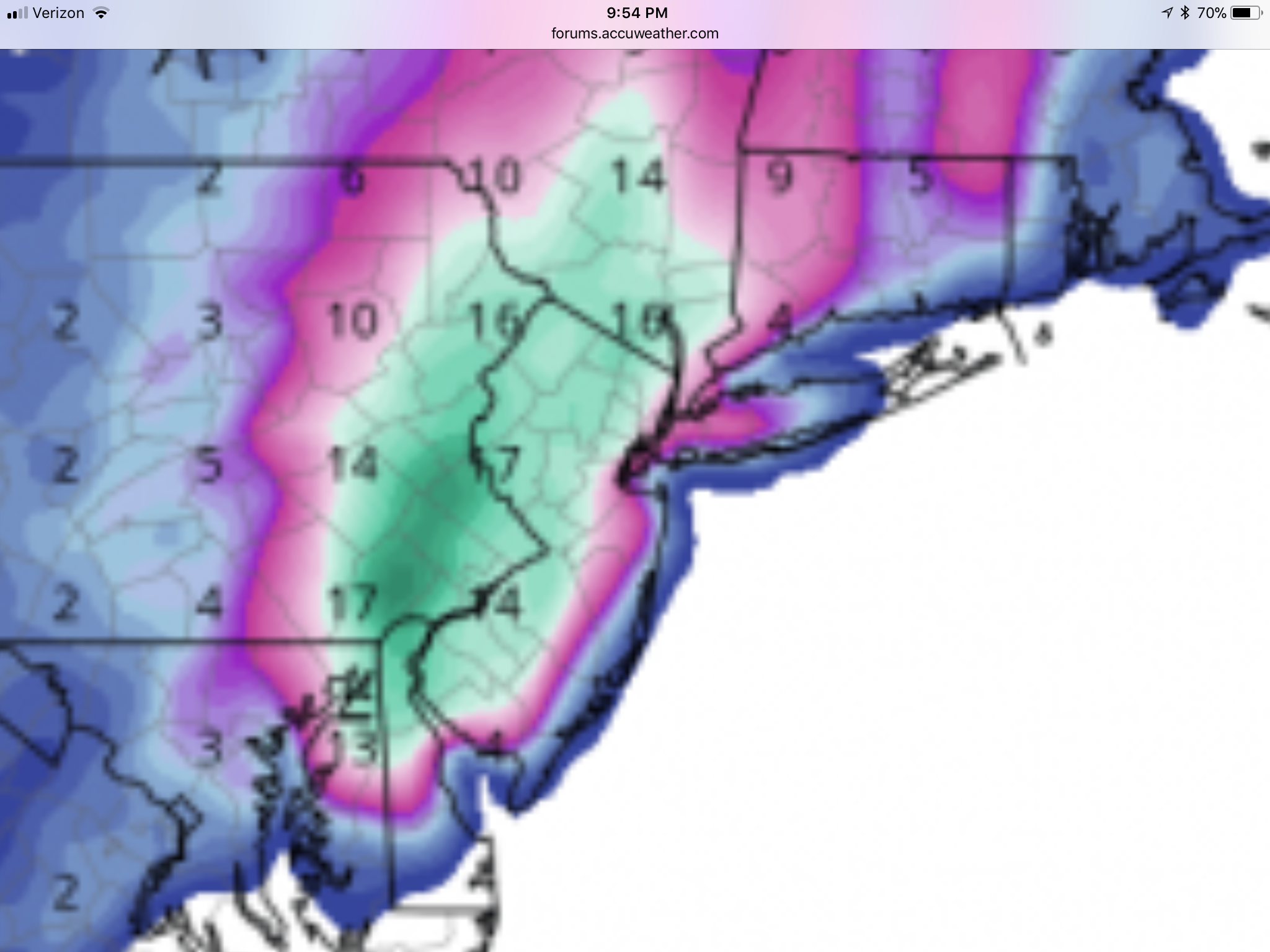
Summary: So, we now have a pretty strong consensus for a moderate (2-4”) to significant (4-8”) and possibly major (8-14”) snowstorm impacting our area from before sunrise on Wednesday into Weds night. Four of the 6 global/mesoscale models are showing a general 8-12” (and even up to 18” in 1-2 models) snowstorm for Philly to NYC and points NW of that line and a rain to snow scenario for the coast with possibly only a few to several inches of snow there. But the Euro (stilll the best model) is showing a 2-4” event for the 95 corridor and 4-8” towards the Shore and on LI and the CMC is showing a bit less than that even, but that is usually the worst scoring global. We’re still 60 hours from the event, so it’s still possible to get more rain than snow along 95, if the track moves NW and it’s still possible to get all snow everywhere and it’s still possible to get a light to moderate event from 95 to the coast, with little N/W, if the storm goes further SE. But an all rain inland track and a complete miss out-to-sea track are just about off the table. Today's NWS maps below.
Details: As I described in last night’s update, this is a very different storm from Friday’s. This storm has much more model support and pattern support for snow in the 95 corridor and coast than Friday's did - Friday's was a more powerful and much longer lasting storm (with 2-3 feet of snow for locations in far NW areas that got all snow), but for our area, it relied on perfect dynamics to get some late snow in some places south of 78 that got those dynamics. This storm also won’t have anywhere near the coastal flooding/high winds that Friday’s had.
Getting back to snow, the antecedent air in place will be colder than Friday and there won't also be 1-2" of rain beforehand, both of which greatly increased melting rates vs. what we'll have on Wednesday - although there will still likely be a ~1/4" per hour melting rate on Wednesday vs. the 3/8-1/2" estimated melting rate we had on Friday. In addition, more than half of the precip should fall after 4 pm, meaning the effect of the indirect sunlight will be minimal.
The biggest key is probably this: if one gets a snowfall intensity for an hour or so that overcomes the melting rate (like 2/17 and Friday in places with very high intensity snowfall), then a layer of snow becomes established on the ground, which then means subsequent snowfall accumulates easily, since the snow is 32F, which means no melting from the air temps, plus snow reflects 80-90% of the indirect sunlight (as opposed to grass which only reflects 25% of sunlight and asphalt, which only reflects 5% of sunlight), so much less melting from the surface. And as per most of the models, we expect to get moderate (1/2”/hr) to heavy (1” or more per hour rates) snowfall throughout much of Wednesday, which would be well in excess of the worst melting rate; if we get only light to moderate snowfall, like the Euro/CMC, much of the falling snow will likely melt.
The NWS posted snowfall maps for moderate snowfall earlier today, when there was less model consensus on a potential major snowstorm, so their maps of a general 3-5” level event reflect that. However, with the 18Z and most recent 00Z model runs (7 pm EST data input) showing a pretty strong consensus on at least a significant snowfall for most, I would expect to see those snowfall predictions increase to more like 4-8” and to also see them possibly issuing winter storm watches with the NWS 4 am package, as that's 48 hours before the storm, when they often start issuing watches; could also see them wanting to see one more model suite at 12Z tomorrow before pulling that trigger.
With regard to other effects, there will be some wind, perhaps enough to get close to blizzard conditions (frequent 35 mph gusts), especially near the coast, but not like Friday’s winds; same for coastal flooding – could be minor with this event, at most. And while the wind, alone, won’t be enough for power outages, in some places we could have more power outages if we get a major snowfall of fairly wet snow that sticks to trees. Sometimes just having enough snow on the trees is enough, even without wind. The Oct 2011 storm was like that - not much wind, but heavy wet snow bringing down branches and trees. What you want is a dry enough snow and some wind, so that the snow doesn't accumulate much on the trees.
Finally, there is at least one more chance of a winter storm for next Sunday/Monday, 3/11-12. The pattern we’re in with the –NAO (Greenland blocking high) is very conducive to fairly cold and potentially snowy weather. Way far out to forecast for, but worth watching.