There will be some freezing, but even the side streets by me are down to pavement after about 5-6 inches. They have been salted and will have a chance to dry out a bit before the freeze overnight. Last weather event was worse because we got stuck with an extended period of freezing drizzle/mist followed by much colder temperatures.Around 3 '' snowfall in East Brunswick.Toro snow blower started on first shot.Lots of melting happening in the afternoon.Concerned about freezing overnight.


Colleges
- American Athletic
- Atlantic Coast
- Big 12
- Big East
- Big Ten
- Colonial
- Conference USA
- Independents (FBS)
- Junior College
- Mountain West
- Northeast
- Pac-12
- Patriot League
- Pioneer League
- Southeastern
- Sun Belt
- Army
- Charlotte
- East Carolina
- Florida Atlantic
- Memphis
- Navy
- North Texas
- Rice
- South Florida
- Temple
- Tulane
- Tulsa
- UAB
- UTSA
- Boston College
- California
- Clemson
- Duke
- Florida State
- Georgia Tech
- Louisville
- Miami (FL)
- North Carolina
- North Carolina State
- Pittsburgh
- Southern Methodist
- Stanford
- Syracuse
- Virginia
- Virginia Tech
- Wake Forest
- Arizona
- Arizona State
- Baylor
- Brigham Young
- Cincinnati
- Colorado
- Houston
- Iowa State
- Kansas
- Kansas State
- Oklahoma State
- TCU
- Texas Tech
- UCF
- Utah
- West Virginia
- Illinois
- Indiana
- Iowa
- Maryland
- Michigan
- Michigan State
- Minnesota
- Nebraska
- Northwestern
- Ohio State
- Oregon
- Penn State
- Purdue
- Rutgers
- UCLA
- USC
- Washington
- Wisconsin
High School
- Illinois HS Sports
- Indiana HS Sports
- Iowa HS Sports
- Kansas HS Sports
- Michigan HS Sports
- Minnesota HS Sports
- Missouri HS Sports
- Nebraska HS Sports
- Oklahoma HS Sports
- Texas HS Hoops
- Texas HS Sports
- Wisconsin HS Sports
- Cincinnati HS Sports
- Delaware
- Maryland HS Sports
- New Jersey HS Hoops
- New Jersey HS Sports
- NYC HS Hoops
- Ohio HS Sports
- Pennsylvania HS Sports
- Virginia HS Sports
- West Virginia HS Sports
ADVERTISEMENT
Install the app
How to install the app on iOS
Follow along with the video below to see how to install our site as a web app on your home screen.
Note: This feature may not be available in some browsers.
You are using an out of date browser. It may not display this or other websites correctly.
You should upgrade or use an alternative browser.
You should upgrade or use an alternative browser.
OT: Significant (CNJ) to Major (Along/N of 78) Winter Storm Likely on Tuesday (2/12-13; much less uncertainty on outcome)
- Thread starter RU848789
- Start date
Eastern Monmouth County here. Got about 3-4 real wet snow. I bought an EGO snow blower last year and never used it but used it a few weeks ago in the light snow and it worked great. Was real worried with this real heavy wet stuff. Very happy to say it worked like a charm and blew it pretty far. I have pretty large driveway and had no issues at all with charges in the batteries . Thanks #'s

43 degrees and sunny! The white stuff is disappearing even quicker than at a @mildone weekend blow session.
Yes, I took you off ignore to make that joke. You had a long enough time-out!
Yes, I took you off ignore to make that joke. You had a long enough time-out!
They were going the wrong way! 😁 My niece lives Lansdale, my youngest sister live in Orefield near Allentown. You didn't want to go North this morning!a few peeps I work with said it took them 3 hours to go from philly to Lansdale this morning
Northern part?Eastern Monmouth County here. Got about 3-4 real wet snow. I bought an EGO snow blower last year and never used it but used it a few weeks ago in the light snow and it worked great. Was real worried with this real heavy wet stuff. Very happy to say it worked like a charm and blew it pretty far. I have pretty large driveway and had no issues at all with charges in the batteries . Thanks #'s
Our driveway is completely clear an dry by not doing a single thing. Storm was nothing. Ocean County (Brick) is across the street and river from us.
Likely give you a VP word saladAre you giving us "the finger" in that picture? 😜
Didn't pan out here in South Wall. Sun is out, and all the snow on driveway melted. Not much on grass either, can see blades pocking through the snow.
Can the "bust" be explained? There was a high degree of confidence we would see 2-4", maybe 3-5" here. Not disappointed, just curious.
Was a weird storm with many "busts" as the storm just kept defying the models and mets. Its last act was to move nearly 200 miles further SE than modeled 2 days ago, which everyone assumed would then mean that 95 and the coast would get the most snow, being closer to the precip source and cold enough to snow (instead of rain, which would've been a given with a much further inland track). Sounds good, but the storm then delivered a fair amount more precip (snow) to areas well NW of 95 and the amount of precip for 95 and the coast was less, plus temps were warmer especially near the coast, so less of what fell accumulated. The problem for much of the 95 corridor ended up being a "subsidence" band (descending, denser, cooler air that "robs" an area of precip for a time usually in tandem with another area getting great lift of warm moist air aloft to drive precip) that set up SE of the heavy snow bands to the NW (that happens sometimes) and got light to moderate precip for 2-3 hours during prime time of the storm. I got only about 1.4" from 8:30-11:30 am when folks 25+ miles NW probably got 6" during that time. Could've easily had 10" here and not 6". We wuz robbed!Are you giving us "the finger" in that picture? 😜
Didn't pan out here in South Wall. Sun is out, and all the snow on driveway melted. Not much on grass either, can see blades pocking through the snow.
Can the "bust" be explained? There was a high degree of confidence we would see 2-4", maybe 3-5" here. Not disappointed, just curious.
I got 9 inches in MontclairWas a weird storm with many "busts" as the storm just kept defying the models and mets. Its last act was to move nearly 200 miles further SE than modeled 2 days ago, which everyone assumed would then mean that 95 and the coast would get the most snow, being closer to the precip source and cold enough to snow (instead of rain, which would've been a given with a much further inland track). Sounds good, but the storm then delivered a fair amount more precip (snow) to areas well NW of 95 and the amount of precip for 95 and the coast was less, plus temps were warmer especially near the coast, so less of what fell accumulated. The problem for much of the 95 corridor ended up being a "subsidence" band (descending, denser, cooler air that "robs" an area of precip for a time usually in tandem with another area getting great lift of warm moist air aloft to drive precip) that set up SE of the heavy snow bands to the NW (that happens sometimes) and got light to moderate precip for 2-3 hours during prime time of the storm. I got only about 1.4" from 8:30-11:30 am when folks 25+ miles NW probably got 6" during that time. Could've easily had 10" here and not 6". We wuz robbed!
What about the snow?I got 9 inches in Montclair
We ended with a long dry slot after a sloppy wet bust. Meanwhile @zappaa got 9 inches. Something to make everyone happy, I guess.Was a weird storm with many "busts" as the storm just kept defying the models and mets. Its last act was to move nearly 200 miles further SE than modeled 2 days ago, which everyone assumed would then mean that 95 and the coast would get the most snow, being closer to the precip source and cold enough to snow (instead of rain, which would've been a given with a much further inland track). Sounds good, but the storm then delivered a fair amount more precip (snow) to areas well NW of 95 and the amount of precip for 95 and the coast was less, plus temps were warmer especially near the coast, so less of what fell accumulated. The problem for much of the 95 corridor ended up being a "subsidence" band (descending, denser, cooler air that "robs" an area of precip for a time usually in tandem with another area getting great lift of warm moist air aloft to drive precip) that set up SE of the heavy snow bands to the NW (that happens sometimes) and got light to moderate precip for 2-3 hours during prime time of the storm. I got only about 1.4" from 8:30-11:30 am when folks 25+ miles NW probably got 6" during that time. Could've easily had 10" here and not 6". We wuz robbed!
Snow is completely melted off the front lawn and driveway is dry without any shoveling, sweeping, etc.
Just a few inches to clear here. Temp close to 40, all hard surfaces are clear and starting to dry.
It’s melting crazy fast from surfaces.
I’d say 5 here in Monmouth county
Streets and driveway are blacktop
If the snow gods wana hold off until next year I’m good w that
Streets and driveway are blacktop
If the snow gods wana hold off until next year I’m good w that
It's not as bad as the person who created a NWS map last night that has 14.4 inches for Philadelphia. So you have that going for you! 😁And before the next Message Board Vigilante strikes, yes I will take a huge L on my early "trending northward" call. While the models were trending north early, it was a huge head-fake and I ended up getting crossed over and seated.
We didn't get as bad tidal flooding as the NWS predicted for Eastern Monmouth because the winds weren't as strong and shifted NE to NW earlier than expected.I’d say 5 here in Monmouth county
Streets and driveway are blacktop
If the snow gods wana hold off until next year I’m good w that
I checked. Only option is a trailer plow. Not feeling it.Put a plow on that Lightning!
Squan?We didn't get as bad tidal flooding as the NWS predicted for Eastern Monmouth because the winds weren't as strong and shifted NE to NW earlier than expected.
I use the electric start which is great. My problem is the wet snow always clog the chute. Very frustratingSame here with my Toro one stage. Bring it out in November and do just that.
I got the electric start option too in case I’m at work and my Wife or kids need it.
But I do drain it at end of the season. And have started keeping less gas on hand for all the power equipment (straight and mixed) because even with the stabilizer it doesn’t stay good.
Public Information Statement
National Weather Service Mount Holly NJ
419 PM EST Tue Feb 13 2024
...FINAL SNOWFALL TOTALS FOR 2/13/24 STORM...
Location Amount Time/Date Provider
...New Jersey...
...Atlantic County...
Atlantic City International T in 0100 PM 02/13 ASOS
...Burlington County...
1 ESE Delran 2.1 in 1100 AM 02/13 Trained Spotter
Maple Shade 1.9 in 1230 PM 02/13 Trained Spotter
1 NNE Rancocas 1.6 in 1215 PM 02/13 NWS Employee
Mount Holly WFO 1.4 in 1225 PM 02/13 Official NWS Obs
Mount Laurel 1.4 in 1240 PM 02/13 Trained Spotter
Medford 1.0 in 1140 AM 02/13 NWS Employee
Moorestown 1.0 in 0115 PM 02/13 Broadcast Media
Marlton 0.9 in 0945 AM 02/13 Trained Spotter
Leisuretowne 0.8 in 1225 PM 02/13 Trained Spotter
...Camden County...
1 W Greentree 1.5 in 1130 AM 02/13 Public
Mount Ephraim 0.9 in 1210 PM 02/13 COCORAHS
...Gloucester County...
Paulsboro 1.1 in 1145 AM 02/13 Public
Wenonah 0.2 SW 0.5 in 0912 AM 02/13 COCORAHS
...Hunterdon County...
2 SW Tewksbury Twp 8.0 in 1230 PM 02/13 Public
Flemington 7.6 in 1200 PM 02/13 Trained Spotter
Readington Twp 7.5 in 1000 AM 02/13 Trained Spotter
Flemington 1.9 SE 7.0 in 1200 PM 02/13 COCORAHS
Readington 6.5 in 1231 PM 02/13 Trained Spotter
Clinton Twp. 4 N 6.0 in 0830 AM 02/13 COCORAHS
Bloomsbury 5.0 in 0145 PM 02/13 Public
Glen Gardner 4.9 in 0650 AM 02/13 Public
...Mercer County...
Woodsville 6.8 in 1233 PM 02/13 Trained Spotter
Princeton 4.5 in 1236 PM 02/13 Trained Spotter
Trenton Mercer Airport 4.2 in 0100 PM 02/13 ASOS
Hopewell Twp. 2.4 NW 4.0 in 0909 AM 02/13 COCORAHS
Ewing 2.3 in 0935 AM 02/13 Trained Spotter
Hamilton Square 1.4 in 1237 PM 02/13 Trained Spotter
...Middlesex County...
Metuchen 6.1 in 1230 PM 02/13 Public
South Plainfield 5.5 in 1100 AM 02/13 Amateur Radio
Iselin 5.0 in 1240 PM 02/13 Trained Spotter
Highland Park 4.5 in 1100 AM 02/13 Amateur Radio
Edison 4.3 in 1238 PM 02/13 Trained Spotter
1 W North Brunswick 4.3 in 0100 PM 02/13 Public
New Brunswick 3 SE 4.0 in 0800 AM 02/13 COOP
1 ESE Kendall Park 4.0 in 1220 PM 02/13 Public
North Brunswick 4.0 in 1215 PM 02/13 Public
East Brunswick 3.6 in 1100 AM 02/13 Amateur Radio
South Amboy 3.5 in 1100 AM 02/13 Amateur Radio
Cranbury 2.7 in 1220 PM 02/13 Other Federal
...Monmouth County...
1 SSW Freehold 5.1 in 1250 PM 02/13 Trained Spotter
Holmdel 5.0 in 0130 PM 02/13 Trained Spotter
3 NE Perrineville 4.2 in 0130 PM 02/13 Trained Spotter
Middletown 4.0 in 1230 PM 02/13 Public
1 ENE Atlantic Highlands 3.5 in 0100 PM 02/13 Public
1 NNW Clarksburg 3.3 in 1240 PM 02/13 Cocorahs
Tinton Falls 3.2 in 0100 PM 02/13 Broadcast Media
1 N Colts Neck Twp 3.1 in 0120 PM 02/13 Cocorahs
Union Beach 2.1 SSE 3.0 in 0800 AM 02/13 COCORAHS
Marlboro 2.5 in 0900 AM 02/13 COOP
Monmouth Beach 2.2 in 1105 AM 02/13 Public
Little Silver 0.3 NNW 2.1 in 0900 AM 02/13 COCORAHS
2 SSE Howell 2.0 in 0100 PM 02/13 Cocorahs
Red Bank 2.0 in 1110 AM 02/13 Public
Keyport 1.5 in 1050 AM 02/13 Trained Spotter
Manasquan 1.2 in 1012 AM 02/13 CO-OP Observer
...Morris County...
Green Pond 11.5 in 0130 PM 02/13 Trained Spotter
Randolph Twp 2.2 SE 11.5 in 1137 AM 02/13 COCORAHS
Randolph 11.5 in 1136 AM 02/13 Trained Spotter
Denville 10.2 in 1210 PM 02/13 Trained Spotter
Kinnelon 1.4 SE 10.0 in 1000 AM 02/13 COCORAHS
Budd Lake 9.2 in 1120 AM 02/13 Public
Lake Hopatcong 9.2 in 1130 AM 02/13 Trained Spotter
1 WSW Milton 9.1 in 0145 PM 02/13 Trained Spotter
Morris Plains 9.1 in 1200 PM 02/13 Public
Butler 9.0 in 1120 AM 02/13 Trained Spotter
2 NNE Califon 9.0 in 1107 AM 02/13 Trained Spotter
Mount Arlington 8.5 in 0100 PM 02/13 Trained Spotter
Montville 8.0 in 0200 PM 02/13 Public
Roxbury Twp. 8.0 in 0700 AM 02/13 COCORAHS
1 WSW Mountain Lakes 8.0 in 1206 PM 02/13 Cocorahs
Rockaway 8.0 in 0100 PM 02/13 Trained Spotter
Chatham 7.8 in 0100 PM 02/13 Public
Whippany 7.5 in 1100 AM 02/13 Trained Spotter
2 SW Schooleys Mountain 7.3 in 1110 AM 02/13 Public
Pequannock 7.0 in 1200 PM 02/13 Trained Spotter
Parsippany-Troy Hills Twp 7.0 in 1120 AM 02/13 Public
Millington 6.9 in 1110 AM 02/13 Public
Boonton 6.0 in 1015 AM 02/13 Public
Ledgewood 6.0 in 0902 AM 02/13 Public
Pompton Plains 6.0 in 1010 AM 02/13 Public
...Ocean County...
2 NE Brick 1.7 in 0100 PM 02/13 Trained Spotter
...Somerset County...
Watchung 1.4 WNW 8.5 in 1145 AM 02/13 COCORAHS
3 W Belle Mead 8.3 in 1152 AM 02/13 Public
Far Hills 1 S 7.5 in 1200 PM 02/13 COCORAHS
Basking Ridge 7.3 in 1207 PM 02/13 Trained Spotter
3 SSE Far Hills 7.0 in 0100 PM 02/13 Public
Martinsville 7.0 in 1230 PM 02/13 Public
Hillsborough Twp 6.5 in 1235 PM 02/13 Trained Spotter
North Plainfield 6.2 in 1215 PM 02/13 Trained Spotter
Neshanic Station 6.0 in 1145 AM 02/13 Public
2 N Bridgewater 5.5 in 0100 PM 02/13 Cocorahs
2 ENE Montgomery Twp 5.3 in 1200 PM 02/13 Trained Spotter
Green Brook Twp 5.0 in 1130 AM 02/13 Trained Spotter
Middlebush 4.5 in 1230 PM 02/13 Cocorahs
Franklin Twp 3.8 ENE 4.1 in 0900 AM 02/13 COCORAHS
Millstone 3.0 in 1034 AM 02/13 Broadcast Media
...Sussex County...
Sussex 15.0 in 1228 PM 02/13 Trained Spotter
1 SSE Montague 14.8 in 0218 PM 02/13
Hampton Twp 13.0 in 0935 AM 02/13 Trained Spotter
Sparta 12.5 in 0930 AM 02/13 Trained Spotter
Sandyston Twp 12.3 in 1200 PM 02/13 Public
Vernon 12.1 in 1130 AM 02/13 Public
Ogdensburg 11.7 in 0100 PM 02/13 Public
Wantage Twp 11.6 in 1100 AM 02/13 Public
3 SSW High Point 11.3 in 1045 AM 02/13 Trained Spotter
Lafayette Twp 11.0 in 1105 AM 02/13 Trained Spotter
Newton 11.0 in 1200 PM 02/13 Public
3 N Pellettown 11.0 in 1045 AM 02/13 Trained Spotter
1 SSW Hamburg 10.7 in 1240 PM 02/13 Public
1 S Hardyston Twp 9.9 in 1130 AM 02/13 Cocorahs
Franklin 9.5 in 1100 AM 02/13 Public
Byram Twp 9.0 in 1050 AM 02/13 Public
Hopatcong 8.5 in 1208 PM 02/13 Trained Spotter
...Warren County...
Blairstown 12.0 in 1045 AM 02/13 Cocorahs
2 SE Knowlton Twp 10.4 in 1045 AM 02/13 Cocorahs
1 SSW Harmony 9.8 in 1100 AM 02/13 Trained Spotter
Knowlton Twp 1.7 S 9.8 in 0845 AM 02/13 COCORAHS
Hackettstown 9.0 in 1030 AM 02/13 Trained Spotter
Liberty Twp 8.5 in 1130 AM 02/13 Public
1 ENE Pohatcong Twp 8.3 in 1159 AM 02/13 Cocorahs
Washington Twp. 1.8 SE 8.0 in 1200 PM 02/13 COCORAHS
Phillipsburg 8.0 in 1100 AM 02/13 Public
Stewartsville 8.0 in 1030 AM 02/13 Trained Spotter
...Bergen County...
River Vale 9.8 in 1257 PM 02/13 Trained Spotter
Franklin Lakes 9.1 in 1138 AM 02/13 Public
Waldwick 9.0 in 0150 PM 02/13 Public
1 ESE Westwood 8.3 in 1200 PM 02/13 Trained Spotter
Bergenfield 8.1 in 1235 PM 02/13 Trained Spotter
Mahwah 8.0 in 0125 PM 02/13 Public
1 W Fair Lawn 7.0 in 0315 PM 02/13 Public
Lyndhurst 6.5 in 0110 PM 02/13 Trained Spotter
1 NNE Rutherford 5.5 in 1230 PM 02/13 Public
...Essex County...
Essex Fells 9.5 in 1216 PM 02/13 Public
1 SSW West Orange 8.0 in 1200 PM 02/13 Public
2 NE Springfield 7.1 in 1210 PM 02/13 Public
Livingston 7.0 in 1110 AM 02/13 Public
1 N Orange 5.6 in 1134 AM 02/13 Broadcast Media
...Hudson County...
Harrison 5.5 in 1148 AM 02/13 CO-OP Observer
2 NE East Newark 5.0 in 1245 PM 02/13 Trained Spotter
1 SW Hoboken 4.8 in 0115 PM 02/13 Cocorahs
Hoboken 3.9 in 1245 PM 02/13 Trained Spotter
...Passaic County...
Clifton 9.5 in 0217 PM 02/13 Trained Spotter
1 NE West Milford 9.5 in 1155 AM 02/13 Trained Spotter
Totowa 8.5 in 0150 PM 02/13 Public
...Union County...
New Providence 7.9 in 1226 PM 02/13 Trained Spotter
Mountainside 7.5 in 0107 PM 02/13 Public
Cranford 6.0 in 0130 PM 02/13 Trained Spotter
Plainfield 5.7 in 1200 PM 02/13 Public
Rahway 5.0 in 1135 AM 02/13 Trained Spotter
Newark Airport 4.9 in 0100 PM 02/13 Official NWS Obs
1 WSW Elizabeth 4.6 in 1208 PM 02/13 Trained Spotter
Elizabeth 4.6 in 0216 PM 02/13 Trained Spotter
Linden 4.0 in 1141 AM 02/13 Amateur Radio
New York (Manhattan) County...
Central Park 3.2 in 0100 PM 02/13 Official N
...Philadelphia County...
Shawmont 4.5 in 1200 PM 02/13 Trained Spotter
1 NNW Manayunk 3.5 in 0100 PM 02/13 Public
Philadelphia 1.0 in 0900 AM 02/13 COCORAHS
Mantua 1.0 in 1205 PM 02/13 Public
Philadelphia International 0.6 in 0100 PM 02/13 ASOS
Hamilton must have been in The Screw Zone because everything was melted everywhere by the time I got home. I left work in Jamesburg and there were several inches still on grassy surfaces.
Yeah Robbinsville had nothing by sundown.
That reminds me, need to get a De Lo's lunch soon.Yeah Robbinsville had nothing by sundown.
Every met in the business saw the significant northward trend 2-3 days ago and most bit on it (and it made me nervous as hell) either remaining north or continuing further north, since more coastal storms than not trend a bit northward over time, so you're in good company.And before the next Message Board Vigilante strikes, yes I will take a huge L on my early "trending northward" call. While the models were trending north early, it was a huge head-fake and I ended up getting crossed over and seated.
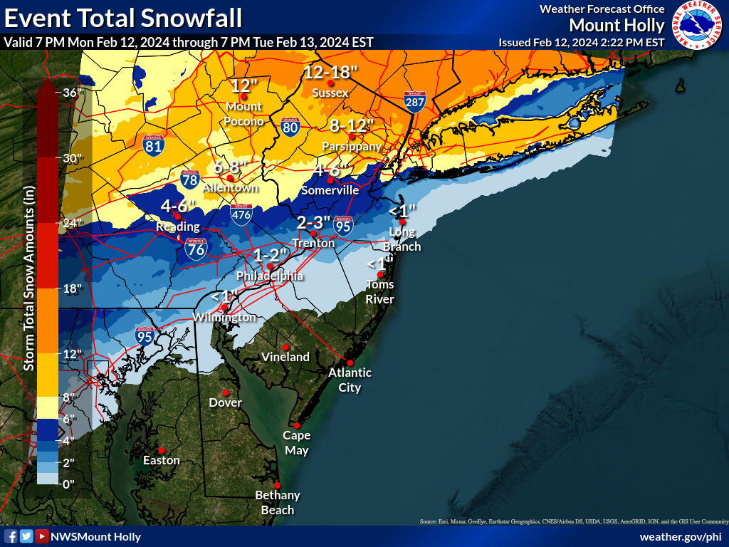
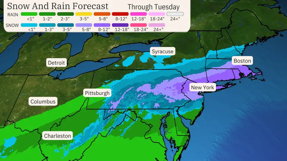
Summary: a major winter storm is on our doorstep, but there are still model disagreements on the exact track and precip/snow amounts, so we need to keep an eye on future model runs and soon the radar and the evolution of the systems involved. The storm starts as rain for everyone in the late evening, but quickly turns to snow in NW areas and takes several hours to change over down towards 95 and the coast; for most of CNJ the snow will fall heavily from about 5 am through about noon. Basically, snowfall amounts of >8" are predicted along and N of 78 (with up to 12-14" N of 80) and most sources agree on that. South of 78 there is much more disagreement. I believe TWC map below, is more likely to be correct than the NWS map. TWC map is more bullish on getting 5-8" from 276/195 up to 78 and even 2-5" down to Philly over to Toms River up to 276/195, while the NWS is predicting more like 2-5" from 276/195 up to 78 and then only 1-2" along the Delaware SW of Trenton to Philly with very little S of 195 in NJ.
Details: So, given the significantly lower snowfall amounts on the Euro and UK (two very good models) vs. the generally greater snowfall amounts for most of the other models, the question is do forecasters do some kind of compromise or go with one camp or another or something else, as they have tools/knowledge most don't. Tough call, especially with the 18Z HRRR showing a huge snowstorm (10-16") for the entire area all the way down to Wilmington to LBI, but less for far NWNJ, as it shifted south maybe 50 miles, and the 18Z NAM also shifting things south a ways and with less precip (8-11" for most of the state, while the 18Z RGEM had 6-10" for everywhere N of 276/195. So there was some movement south but not by all of them and precip amounts weren't as low as on the Euro/UK so who knows? The 18Z models at least make it clear that there likely won't be some huge shift south as some had discussed
Anyway, as expected, the NWS-Philly did increase snowfall amounts south of 78, but not as much as I thought they should and they now have warnings up for Poconos/Sussex for 8-13" of snow, for the Lehigh Valley, Morris, Warren for 7-10" of snow and for Berks, NW Bucks, Hunterdon and Somerset for 4-7" of snow and they have advisories up for Middlesex, Mercer, Lower Bucks and Montco for 3-5" of snow and for Western Monmouth and Chester for 2-4" of snow. IMO, all of those places under advisories should be under warnings for 4-7" of snow, especially given the southward shift we've seen from some of the models which brings more snow further south, which would also likely decrease snowfall amounts by a coupe of inches N of 80. In addition, given that about half the models have 3-6" or more of snow for Philly and SNJ (even at lower ratios), I would expect those areas to at least be under advisories for 2-4" of snow.
Also, the NWS-NYC now has warnings up for Union/Essex/Hudson and NYC/LI for 4-8", warnings up for LI for 5-10", warnings for eastern Passaic, eastern Bergen and Western Essex for 7-10" of snow and warnings for W. Passaic, W. Bergen and the Hudson Valley north of the Bronx for 9-13" of snow (and for CT for 7-12"). It's certainly going to be fun to see this all evolve and for the rain then snow to finally come late tonight with possibly hellacious snowfall rates of 1-2" per hour from 4 am to noon with a quick shut off after that. I still think TWC map is better than the one from the NWS, but we'll see soon.
Tomorrow morning's rush hour has the potential to be extremely difficult from at least 276/195 up through 84 for all of EPA/CNJ/NNJ/NYC/LI/SENY/CT with very heavy snow falling with 8-12" or more along and N of 78 and very possibly up to 8" down to 276/195 which would mean over 1" per hour rates for the 8-9 hours of the snow falling - and even for areas with warmer temps and less accumulation on roads, visibility will be very hindered and roads in some places could become difficult to travel on, especially near/N of 78 and as I've said before where we see >1" per hour rates even at 33-34F, untreated roads will become snow covered as those rates will exceed melting rates.
Lastly, don't forget that minor to moderate coastal flooding is likely for DE/NJ/NY coasts on Tuesday and 40-45 mph winds are likely for coastal areas and 30-35 mph inland as the storm cranks on Tuesday. In addition, for areas that get 6"+ of heavy wet snow/paste that sticks to trees the weight along with the winds could lead to some downed trees/power lines and outages.
And don't forget to shovel before sunset and salt areas as needed, as temps will drop into the mid-20s. Also, be careful out there, but try to enjoy it if you can.
https://www.weather.gov/phi/
https://www.americanwx.com/bb/topic...winter-storm-6-12-for-many-on-feb-13/page/48/
Snowstorm post-mortem...
So let's see how the forecasts did. Figured it's most logical to compare vs. the forecasts from Monday afternoon, which is probably the last forecast 95% of people would see. Overall, both the NWS and TWC did decently with the right general overall ideas of more snow as one went north from 276/195 (and less south of there) to 78 and then 80, but the NWS probably overdid the 12-18" range N of 80, while TWC underdid it. Both did pretty well not biting on the models showing much more snow south of 276/195 and keeping forecasts south of there in check. And while it's not relevant for our area, TWC did terribly on SE New England which only got a few inches of snow; the NWS didn't do much better.
Given how wildly the models fluctuated these weren't bad forecasts. I measured 6" on a snow ratio of 8.3" of snow per 1" melted liquid from that snow in Metuchen and there was a report of 6.1" from someone else in Metuchen on the NWS page, so slightly short of my 7.2" prediction, but that was mostly due to losing intensity to a subsidence zone from about 8:30-11:30 am that probably cost us 2"+ of additional snow, as we only got about 1.5" during that time and areas 15 miles NW of us got 4-5" during that time. Oh well, still a good storm bringing us to 13.3" on the season, which is about 5-6" below normal through this point. Unfortunately, Central Park only got 3.3" with a ratio of about 4.5:1 which is ridiculously low, probably due to the urban heat island effect, as the Bronx go 8" and Coney Island got 7" and Newark got 5".

Last edited:
1 or 2 stage?Eastern Monmouth County here. Got about 3-4 real wet snow. I bought an EGO snow blower last year and never used it but used it a few weeks ago in the light snow and it worked great. Was real worried with this real heavy wet stuff. Very happy to say it worked like a charm and blew it pretty far. I have pretty large driveway and had no issues at all with charges in the batteries . Thanks #'s
2 stages are heavy by design. You don't do much lifting & carrying them once assembled. The EGO is still about 50 pounds lighter than a similar gas powered one.sucker is heavy....looked at it
i have/had a smaller toro and i carry it to the basement every year. that 2 stage EGO is stuck in the garage 365 days. The 1 stage is portable, but would it work and supposedly battery only lasts for 20 minutes.2 stages are heavy by design. You don't do much lifting & carrying them once assembled. The EGO is still about 50 pounds lighter than a similar gas powered one.
I have EGO lawnmower, weedeater and leafblower and love it
We're EGO folks too: have the weedeater and chainsaw, so far, and they're great, and will likely get the leafblower soon, as our old plug-in one is annoying for doing anything beyond the porch or back deck. Still have an old gas Honda push mower and when that dies, I'll probably go with an EGO. A snowblower will never sully my property though - if I could ban one thing on the planet it would be all snowblowers, lol - they ruin the quiet perfection of freshly fallen snow.i have/had a smaller toro and i carry it to the basement every year. that 2 stage EGO is stuck in the garage 365 days. The 1 stage is portable, but would it work and supposedly battery only lasts for 20 minutes.
I have EGO lawnmower, weedeater and leafblower and love it
Was coming here to troll, but it's been so long for you, let me just say:

But there will be another round soon enough! :)
We need to bookmark this as a one of a kind event!
Holy crap, I completely missed this during the storm (was running on fumes and posting in 7 different places in parallel, lol). I feel a little bit like we're in Whoville...We need to bookmark this as a one of a kind event!
Well let's not celebrate too much. You completely whiffed on Philadelphia 🤣🤣Holy crap, I completely missed this during the storm (was running on fumes and posting in 7 different places in parallel, lol). I feel a little bit like we're in Whoville...
The differences in this storm was amazing as big differences were just a few miles away from each other. Literally zero in the city except for car tops and elevated surfaces. About 5 miles away in Belmont Hills we got 3.5 inches remaining as of this morning. We started with hail at home. CC no hail. Just a degree or two can make a huge difference. Officially Philadelphia got .6 at the Airport.
Dusting/coating at most for the Thursday night (after NW) clipper, so no impact really, but the Sat clipper has the potential for 1-2" (and up to 3" in spots) for the whole area (it'll be cold enough from 2 am to 10 am Sat when any snow would fall), as per the Euro, CMC, RGEM, Icon and NBM, while the GFS/NAM/UK have 1" or less generally.Anything with the upcoming clipper (NW game) and Saturday snow showers (big TSC blood drive)?
And even just 1-2" with temps below freezing mostly falling at night will lead to slick untreated roads everywhere until things warm up a bit with the indirect sun. Probably be mostly gone by sunset, but the morning could be impacted. However, nada is still possible, so don't run out and get milk and bread yet; also, the ceiling for this event is probably 3-4", unlike this past storm where the ceiling was pretty high and was realized for many.
Maybe time for a thread? @e5fdny?
Along with possible snow showers there will be big time steady NW winds.Anything with the upcoming clipper (NW game) and Saturday snow showers (big TSC blood drive)?
Windy enough today to take in my smaller flags.Along with possible snow showers there will be big time steady NW winds.
Similar threads
- Replies
- 62
- Views
- 2K
OT: Minor to Moderate (2-4?) Snowfall Likely Sat morning (2/17); will be <32F, so expect slick roads
- Replies
- 213
- Views
- 5K
- Replies
- 477
- Views
- 12K
- Replies
- 592
- Views
- 16K
- Replies
- 771
- Views
- 20K
ADVERTISEMENT
ADVERTISEMENT