Just focusing on tonight, the NWS didn't change any of their advisories or ice storm warnings vs. what they issued yesterday afternoon. However, they noted in the updated map from the NWS-Philly that the forecasted freezing rain along/near 95 is not high confidence, which is what I said after looking at last night's models. Given that the most likely time for freezing rain in this area is between 7 pm and 3 am, the impacts will be lessened and that entire area should be above 32F well before sunrise on Tuesday, with no impact on the morning rush hour, even if some freezing rain falls before then, as it will be melted by the heavy rain.
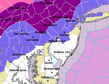
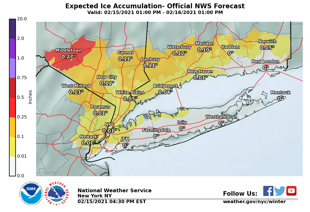
I'm actually surprised they've kept the ice storm warnings up for Somerset, Hunterdon, and Morris in NJ and NW Chester, NW Montco and NW Bucks in PA, as it's highly doubtful these areas (especially the SE parts of the counties) reach the 0.25" ice storm warning criterion. But we'll see. For Sussex, Warren (and NW Morris), the Lehigh Valley/Poconos and the Hudson Valley, this could be a pretty bad icing situation.
https://www.weather.gov/phi/
If most of the 12Z (7 am EST data inputs) models (not all) which just came out are right, it's "Ice Storm Cancel" time for everyone except far NW locations, like the Poconos and NW Sussex and Orange Cty NY and NW of there, as they're all showing temps warming up faster and further than they showed yesterday or last night, meaning less freezing rain. At the very least I'd be surprised if the advisories stay up for the 95 corridor counties and maybe the ice storm warnings move to advisories for the NW areas.
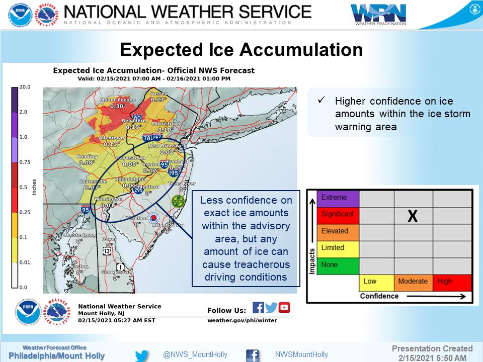
I crashed and burned on my NWS prediction, as they didn't change a thing in their forecast advisories/warnings, but at least they explained why and noted the discrepancies between most of the models and NAM/CAMS, which they put more confidence in - but I doubt they saw the 18Z NAM with no freezing rain (ZR) anywhere along or near the 95 corridor when they wrote this - the 12Z NAM this morning was the only model I saw that had a little bit of freezing rain along 95 (up to 0.1").
In fact, they even increased ice forecasts by a tad for most, as per the ice maps below. I still think there will not be any ZR along 95 and less than forecast to the NW, since the vast majority of models show no ice SE of a line from about New Hope to Morristown to White Plains. We'll see soon. Temps are currently slightly above 32F, but with wet-bulbing (we're not at 100% RH yet and it'll cool a bit when we get to there), temps would be 31-32F for many along 95, so I guess precip could start out as a little freezing rain this evening. Worth watching out for.
https://forecast.weather.gov/produc...&format=CI&version=1&glossary=1&highlight=off
National Weather Service Mount Holly NJ
346 PM EST Mon Feb 15 2021
NEAR TERM /THROUGH TUESDAY/...
**Significant icing still expected for portions of eastern
Pennsylvania and northern New Jersey tonight into early Tuesday
morning**
The storm system that has been affecting the Deep South will
continue to lift northward near the Appalachians, while a secondary
low is forecast to develop and lift northward along the eastern
seaboard tonight through early Tuesday morning. The question becomes
where this secondary low develops and it`s track across the area.
The farther east it goes, the more likely freezing rain will linger
across the northern areas. If it takes even a slightly farther west
shift, the warmer temperatures that a lot of guidance is showing
will take over and change the precipitation to all rain. The cold
high pressure remains across the northern Mississippi Vally, while
nosing around the Great Lakes region and across New England and into
the Mid Atlantic region. The concern is the bend in the surface
pressure fields that noses its way into the Mid Atlantic region,
which continues to indicate a good probability of a cold air damming
situation, even with 2m temperatures forecast trying to warm everyone
above freezing quickly. - Precipitation will begin as a mix of rain where
temperatures are above, and freezing rain and sleet where
temperatures are below freezing, with some snow possible across the
Poconos. Where temperatures stay below freezing through the evening
and overnight , freezing rain becomes the predominate precipitation
type as the warm nose aloft continues to push northward and sleet
becomes less likely. We continue with the Winter Weather Advisories
for portions of southeast Pennsylvania, northern Delaware, and
southern New Jersey where a brief period of freezing rain is
expected to occur before temperatures warm above freezing this
evening and overnight. A glaze of ice and up to a tenth of an inch
of ice is possible in these areas. An Ice Storm Warning remains in
effect for portions of eastern Pennsylvania and northern New Jersey
where ice amounts are forecast to be as much as one-quarter to one-
half of an inch of ice in some areas before many areas warm above
freezing.
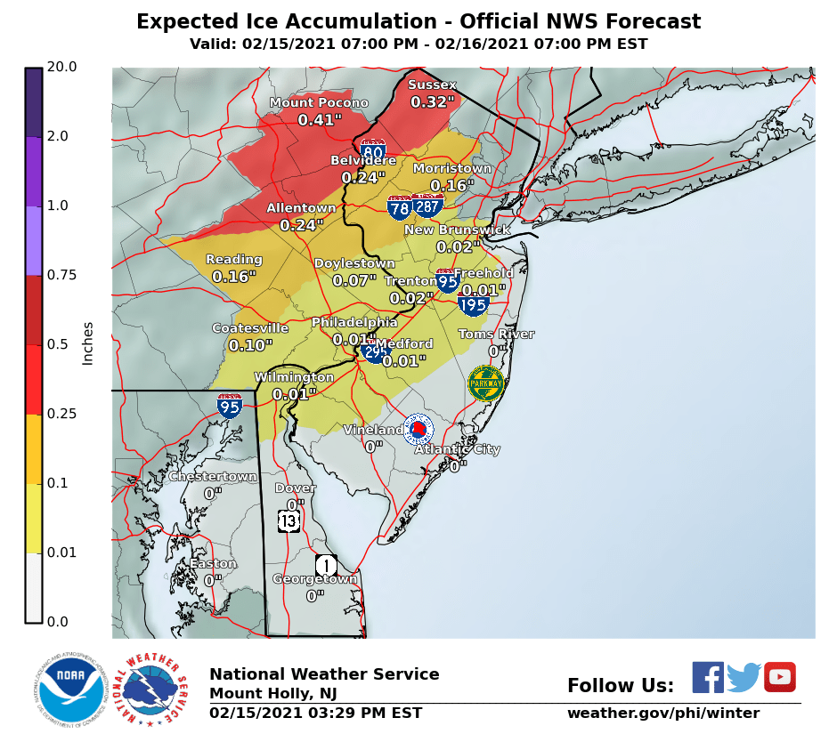
Precipitation will be ending from southwest to northeast during the
morning into the early afternoon Tuesday, so the Warnings will
continue into the mid morning hours. As the storm continues to pull
away and precipitation comes to an end across much of the area, some
snow showers will be possible across portions of northeast
Pennsylvania and northern New Jersey into Tuesday afternoon and
evening. Little to no accumulation is expected if any showers do
develop. Tuesday will warm up quite a bit, so we can expect much of
the ice that fell overnight, in addition to some but not all snow on
the ground to melt some during the day.
Last edited: