Every year, my brother rents a house in Nags Head for 2 weeks to get great rates and brings his 3 dogs. Of course they are there starting their rental Sept. 14th,unreal.


Colleges
- American Athletic
- Atlantic Coast
- Big 12
- Big East
- Big Ten
- Colonial
- Conference USA
- Independents (FBS)
- Junior College
- Mountain West
- Northeast
- Pac-12
- Patriot League
- Pioneer League
- Southeastern
- Sun Belt
- Army
- Charlotte
- East Carolina
- Florida Atlantic
- Memphis
- Navy
- North Texas
- Rice
- South Florida
- Temple
- Tulane
- Tulsa
- UAB
- UTSA
- Boston College
- California
- Clemson
- Duke
- Florida State
- Georgia Tech
- Louisville
- Miami (FL)
- North Carolina
- North Carolina State
- Pittsburgh
- Southern Methodist
- Stanford
- Syracuse
- Virginia
- Virginia Tech
- Wake Forest
- Arizona
- Arizona State
- Baylor
- Brigham Young
- Cincinnati
- Colorado
- Houston
- Iowa State
- Kansas
- Kansas State
- Oklahoma State
- TCU
- Texas Tech
- UCF
- Utah
- West Virginia
- Illinois
- Indiana
- Iowa
- Maryland
- Michigan
- Michigan State
- Minnesota
- Nebraska
- Northwestern
- Ohio State
- Oregon
- Penn State
- Purdue
- Rutgers
- UCLA
- USC
- Washington
- Wisconsin
High School
- Illinois HS Sports
- Indiana HS Sports
- Iowa HS Sports
- Kansas HS Sports
- Michigan HS Sports
- Minnesota HS Sports
- Missouri HS Sports
- Nebraska HS Sports
- Oklahoma HS Sports
- Texas HS Hoops
- Texas HS Sports
- Wisconsin HS Sports
- Cincinnati HS Sports
- Delaware
- Maryland HS Sports
- New Jersey HS Hoops
- New Jersey HS Sports
- NYC HS Hoops
- Ohio HS Sports
- Pennsylvania HS Sports
- Virginia HS Sports
- West Virginia HS Sports
ADVERTISEMENT
Install the app
How to install the app on iOS
Follow along with the video below to see how to install our site as a web app on your home screen.
Note: This feature may not be available in some browsers.
You are using an out of date browser. It may not display this or other websites correctly.
You should upgrade or use an alternative browser.
You should upgrade or use an alternative browser.
OT: Tropics more active...Florence to make NC/SC landfall on 9/14
- Thread starter RU848789
- Start date
Actually, unless damage/flooding is major from a direct hit, the 14th might be ok, as the storm could be well past NC by then. Of course, if it hits NC or just misses and comes near us, getting there on Friday morning from our area could be tough. And the next 2 storms are long term threats in about 1.5-2 weeks.Every year, my brother rents a house in Nags Head for 2 weeks to get great rates and brings his 3 dogs. Of course they are there starting their rental Sept. 14th,unreal.
I get the great rates (it's why we're in OCNJ this week), but with the climatological max in hurricanes in mid-September and the high number of storms that impact NC, that timing is always a bit risky.

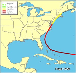
Exactly. As we have seen with the rains from that and Irene, it's no picnic. Particularly in Central Jersey where the Raritan and Millstone come together.A Floyd-like pattern would be bad enough.. we don't need to think of Sandy for every hurricane that threatens
US National Weather Service Philadelphia/Mount Holly
3 mins ·
The risk of Florence impacting the East Coast has increased slightly from yesterday. If and exactly when and where still remains very uncertain at this point. However, it is important to remain aware of the forecast and ensure you have a plan in place in case more direct impacts threaten your area. Now is the time to review and refresh your hurricane preparedness plans and kits. Regardless of where Florence ends up, it is likely that high surf, high rip current risks, and large swells will begin impacting our coastal and offshore waters as soon as early next week. Refer to the NHC's website for the latest forecasts and information regarding Florence: https://www.nhc.noaa.gov/

The latest model runs are not good news for the US east coast, as per below, even though Florence has been weakened to a TS (now 65 mph) by SW shear (was expected). Despite the weakening, Florence is expected to enter a lower shear environment shortly and a warmer SST (sea surface temps) region too, which should allow Florence to reintensify, probably to major hurricane status (125 mph) again by Day 5, as per the NHC forecast.
With regard to the models, last night's operational Euro having landfall near Myrtle Beach as a Cat 3/4 storm in 6-7 days and heading inland after that with flooding rains for NC and western VA/WV/MD/PA and this morning's operational GFS having Florence grazing the Outer Banks on Day 6-7, as a Cat 3/4 and then moving up the DelMarVa (weakened to a cat 1, but moving slowly, so flooding rains are a major concern from NC to New England, including our area next Sat, with this outcome - much of this area is already near saturation from a wet summer, so 5-10" of rain on top of that would be a major concern).
Keep in mind that these are model outputs, not forecasts, with the major point being that a US impact is becoming more likely, especially since we're now only 6-7 days away from a possible landfall. And many of the Euro/GFS ensemble members (variations on the operational models discussed above) still show a recurve out to sea, missing the east coast - as well as landfalls in northern FL up to SC. FYI, no models are showing anything like Sandy, i.e., a NW-ward moving hurricane-force storm striking NJ.
A US east coast landfall is becoming more likely, for a variety of reasons, including the weakened storm having moved further south than originally forecast a few days ago (if it's new starting point is further south, it's ending point, i.e., landfall, is more likely to be further SW), plus, as discussed above, the global models are becoming more bullish on an east coast landfall, due to the anomalously strong western Atlantic ridge (strong high pressure) that is in place now and should still be by early next week, which would steer the storm mostly W or NW.
However, there is still the chance that Florence could be picked up by a trough approaching the east coast in the Monday/Tuesday timeframe causing the storm to recurve out to sea, missing the east coast. But the current Euro discounts the influence of that trough and the GFS is influenced by the trough, but too late to have it miss the US. There are other global models and most of them show a US landfall or a close call, including the CMC with a NC landfall and the UK looking like a SC/NC landfall (only goes out 6 days).
It's also interesting to note that of the hundreds of tropical systems that have been within 150 miles of where Florence is forecast to be tomorrow, none of them made a US landfall and that even where Florence will be on Day 4, only 3 storms made US landfall (Dora in 1964 as a Cat 3 in St. Augustine, Ginger, which hit Morehead City, NC in 1971, and the 1933 Chesapeake hurricane, which looks a lot like the 6Z GFS). The fact that we're even discussing US landfalls is mostly due to that anomalously strong western Atlantic ridge.

If folks want the gory details of all the model runs and more the weather board threads are the place to be and for great discussions, the NHC site and Wunderground are great.
https://www.33andrain.com/topic/1404-tropical-storm-florence-70mph-993mb/?page=32
https://www.americanwx.com/bb/topic/51502-hurricane-florence-catch-all-thread/?page=4
https://www.nhc.noaa.gov/graphics_at1.shtml?cone#contents
https://www.wunderground.com/cat6
Lastly, we're very likely to see Invest 92L, which is several hundred miles SW of the Cape Verde Islands, named Helene sometime today, and we're likely to see Invest 93L, which is just coming off the coast of Africa, near the Cape Verde Islands, named Isaac in the next day or two. Both are long-term threats to the Caribbean and beyond (especially Helene).
#s - thanks for the putting up with the trolls/drunks. This insightful breakdown and analysis gives me an insight into how much attention I need to pay to the storm - and helps me with my travel schedule and booking flight hedges.
US National Weather Service Philadelphia/Mount Holly
3 mins ·
The risk of Florence impacting the East Coast has increased slightly from yesterday. If and exactly when and where still remains very uncertain at this point. However, it is important to remain aware of the forecast and ensure you have a plan in place in case more direct impacts threaten your area. Now is the time to review and refresh your hurricane preparedness plans and kits. Regardless of where Florence ends up, it is likely that high surf, high rip current risks, and large swells will begin impacting our coastal and offshore waters as soon as early next week. Refer to the NHC's website for the latest forecasts and information regarding Florence: https://www.nhc.noaa.gov/
Thank you, your info is good and trustworthy
Thank you, your info is good and trustworthy
Happy hour started at breakfast today, huh?
Great info, thanks for keeping us updated! Truly appreciate all that you and Bac do.
Heading up to Killington, Vermont next weekend for an OCR on Saturday.
1. I know the forecast is in flux, but any idea what the weather conditions most likely could look like up there? Trying to plan out what clothes/gear to consider packing.
2. Wife and kids (2.5 year old and 1.5 year old) were going to come up as well for the rest of the weekend. Should I start trying to talk her into staying home since the weekend will potentially be a washout?
Mr. G? Really? Nice man, delivered decent weather forecasts that real meteorologists made in a friendly easy to understand manner, but he's the guy you're going to go to for in-depth analysis of Florence? The man can't even button his shirt properly. Next thing you know you'll be quoting Lonnie Quinn. Stick with posting useful info (like the NHC/NWS links).
Mr. G? Really? Nice man, delivered decent weather forecasts that real meteorologists made in a friendly easy to understand manner, but he's the guy you're going to go to for in-depth analysis of Florence? The man can't even button his shirt properly. Next thing you know you'll be quoting Lonnie Quinn. Stick with posting useful info (like the NHC/NWS links).
That would be a first for you
The latest model runs are not good news for the US east coast, as per below, even though Florence has been weakened to a TS (now 65 mph) by SW shear (was expected). Despite the weakening, Florence is expected to enter a lower shear environment shortly and a warmer SST (sea surface temps) region too, which should allow Florence to reintensify, probably to major hurricane status (125 mph) again by Day 5, as per the NHC forecast.
With regard to the models, last night's operational Euro having landfall near Myrtle Beach as a Cat 3/4 storm in 6-7 days and heading inland after that with flooding rains for NC and western VA/WV/MD/PA and this morning's operational GFS having Florence grazing the Outer Banks on Day 6-7, as a Cat 3/4 and then moving up the DelMarVa (weakened to a cat 1, but moving slowly, so flooding rains are a major concern from NC to New England, including our area next Sat, with this outcome - much of this area is already near saturation from a wet summer, so 5-10" of rain on top of that would be a major concern).
Keep in mind that these are model outputs, not forecasts, with the major point being that a US impact is becoming more likely, especially since we're now only 6-7 days away from a possible landfall. And many of the Euro/GFS ensemble members (variations on the operational models discussed above) still show a recurve out to sea, missing the east coast - as well as landfalls in northern FL up to SC. FYI, no models are showing anything like Sandy, i.e., a NW-ward moving hurricane-force storm striking NJ.
A US east coast landfall is becoming more likely, for a variety of reasons, including the weakened storm having moved further south than originally forecast a few days ago (if it's new starting point is further south, it's ending point, i.e., landfall, is more likely to be further SW), plus, as discussed above, the global models are becoming more bullish on an east coast landfall, due to the anomalously strong western Atlantic ridge (strong high pressure) that is in place now and should still be by early next week, which would steer the storm mostly W or NW.
However, there is still the chance that Florence could be picked up by a trough approaching the east coast in the Monday/Tuesday timeframe causing the storm to recurve out to sea, missing the east coast. But the current Euro discounts the influence of that trough and the GFS is influenced by the trough, but too late to have it miss the US. There are other global models and most of them show a US landfall or a close call, including the CMC with a NC landfall and the UK looking like a SC/NC landfall (only goes out 6 days).
It's also interesting to note that of the hundreds of tropical systems that have been within 150 miles of where Florence is forecast to be tomorrow, none of them made a US landfall and that even where Florence will be on Day 4, only 3 storms made US landfall (Dora in 1964 as a Cat 3 in St. Augustine, Ginger, which hit Morehead City, NC in 1971, and the 1933 Chesapeake hurricane, which looks a lot like the 6Z GFS). The fact that we're even discussing US landfalls is mostly due to that anomalously strong western Atlantic ridge.
If folks want the gory details of all the model runs and more the weather board threads are the place to be and for great discussions, the NHC site and Wunderground are great.
https://www.33andrain.com/topic/1404-tropical-storm-florence-70mph-993mb/?page=32
https://www.americanwx.com/bb/topic/51502-hurricane-florence-catch-all-thread/?page=4
https://www.nhc.noaa.gov/graphics_at1.shtml?cone#contents
https://www.wunderground.com/cat6
Lastly, we're very likely to see Invest 92L, which is several hundred miles SW of the Cape Verde Islands, named Helene sometime today, and we're likely to see Invest 93L, which is just coming off the coast of Africa, near the Cape Verde Islands, named Isaac in the next day or two. Both are long-term threats to the Caribbean and beyond (especially Helene).
Today's 12Z (7 am EST data inputs) model suite continues to suggest that a US landfall is becoming very likely in 6-7 days, most likely anywhere from northern Florida to the Outer Banks and possibly even the DelMarVa or NJ/LI/New England (although if it misses NC it would take another day or two to reach those locations). A complete miss, recurving out to sea, is becoming much less likely, due to that highly anomalous western Atlantic ridge (WAR; Bermuda High) I've been talking about, which will likely keep it moving W to WNW, but a recurve is still possible.
For a great discussion of this anomalous WAR, see the post by DT/WxRisk from earlier today, where he references "Black Swan" the great book on statistics and anomalies (which applies to markets and weather and other systems) by Nicholas Taleb, which was spot on: "in anomalous events usual techniques and procedure fail. The tried and tested rules and methods break down," which is why looking at historical analogs for Florence (all of which would show a miss) just won't work, as the anomalous WAR is largely why Florence is likely to make US landfall.
<iframe src="https://www.facebook.com/plugins/post.php?href=https://www.facebook.com/WxRisk/posts/1854546904592559&width=500" width="500" height="430" style="border:none;overflow:hidden" scrolling="no" frameborder="0" allowTransparency="true" allow="encrypted-media"></iframe>
If we still see model runs like these tomorrow the storm's track will then be right at the edge of the NHC's 5-day forecast cone and it'll very likely show a US landfall. And as of right now, the models are showing that the western Atlantic ridge is likely to be strong enough to now allow recurvature and a complete miss. Yes, that could change, but time is running out for that outcome. It would be nice to have a hurricane hunter flight, but Florence is too far away for that right now and we won't get one until tomorrow - without that, the error bars will likely remain high on the storm's track and intensity forecasts.
With regard to the models, briefly, the Euro (still the best model) has remained fairly consistent with a landfall in SC/NC for the past few cycles, with the 12Z model showing a landfall not far north of Charleston, SC sometime Thursday evening, probably as a Cat 2/3 storm, while the 12Z GFS is showing a landfall near Cape Hatteras as a Cat 4 storm Thursday afternoon, but the GFS is known to overdo it on pressure (predicting pressures to be lower than actual). The UK has a landfall near the GA/SC border and the CMC has a landfall near Savannah.
Once again, the exact point is immaterial right now - the point is that these 4 major global models are all showing US landfalls from GA to NC 6+ days out, which is fairly impressive consensus at this range. People in those areas and even down to FL and up to New England, need to pay close attention, as this will likely become a very dangerous hurricane with all the impacts normally associated with such a storm, including storm surge, high winds, potential tornadoes, torrential rains, etc. And the torrential rains and reduced but high winds will likely be felt well inland - and even if it's a landfall in NC, for example, there could still be torrential rains in the NJ area 1-2 days after landfall - and high surf/beach erosion is now a given for most of the east coast starting early next week.

Last edited:

Long winded hot air that basically says it could hit from Florida to Maine.
Avoid wasting your time reading his posts
You'll thank me later
Yep, long-winded at times, but many people like the details and insights. You don't, which is fine - you and others are free to ignore my posts, but instead you troll them, cluttering up what is a generally useful thread. Your next useful post will be your first.
Yep, long-winded at times, but many people like the details and insights. You don't, which is fine - you and others are free to ignore my posts, but instead you troll them, cluttering up what is a generally useful thread. Your next useful post will be your first.
Don't listen to him. i have people coming out of the woodwork asking me about your forecast. Thanks for all you do.
He keeps moving the goalposts.
I laugh at you guys stroking his ego
Show your work - haven't moved any goal posts. Should just ignore you, but I have some free time and sometimes I like shooting fish in a barrel.

He keeps moving the goalposts.
I laugh at you guys stroking his ego
So what do you think a weather thread should be?
Should it be a prediction X days out that we score on accuracy?
Or is it a thread kept up to date with updated predictions as results come in?
For me, when I click on this thread I want to see the latest news/prediction. Don't care much about "goalposts" unless there is some kind of game going on.. is there?
That map . . .Today's 12Z (7 am EST data inputs) model suite continues to suggest that a US landfall is becoming very likely in 6-7 days, most likely anywhere from northern Florida to the Outer Banks and possibly even the DelMarVa or NJ/LI/New England (although if it misses NC it would take another day or two to reach those locations). A complete miss, recurving out to sea, is becoming much less likely, due to that highly anomalous western Atlantic ridge (WAR; Bermuda High) I've been talking about, which will likely keep it moving W to WNW, but a recurve is still possible.
For a great discussion of this anomalous WAR, see the post by DT/WxRisk from earlier today, where he references "Black Swan" the great book on statistics and anomalies (which applies to markets and weather and other systems) by Nicholas Taleb, which was spot on: "in anomalous events usual techniques and procedure fail. The tried and tested rules and methods break down," which is why looking at historical analogs for Florence (all of which would show a miss) just won't work, as the anomalous WAR is largely why Florence is likely to make US landfall.
<iframe src="https://www.facebook.com/plugins/post.php?href=https://www.facebook.com/WxRisk/posts/1854546904592559&width=500" width="500" height="430" style="border:none;overflow:hidden" scrolling="no" frameborder="0" allowTransparency="true" allow="encrypted-media"></iframe>
If we still see model runs like these tomorrow the storm's track will then be right at the edge of the NHC's 5-day forecast cone and it'll very likely show a US landfall. And as of right now, the models are showing that the western Atlantic ridge is likely to be strong enough to now allow recurvature and a complete miss. Yes, that could change, but time is running out for that outcome. It would be nice to have a hurricane hunter flight, but Florence is too far away for that right now and we won't get one until tomorrow - without that, the error bars will likely remain high on the storm's track and intensity forecasts.
With regard to the models, briefly, the Euro (still the best model) has remained fairly consistent with a landfall in SC/NC for the past few cycles, with the 12Z model showing a landfall not far north of Charleston, SC sometime Thursday evening, probably as a Cat 2/3 storm, while the 12Z GFS is showing a landfall near Cape Hatteras as a Cat 4 storm Thursday afternoon, but the GFS is known to overdo it on pressure (predicting pressures to be lower than actual). The UK has a landfall near the GA/SC border and the CMC has a landfall near Savannah.
Once again, the exact point is immaterial right now - the point is that these 4 major global models are all showing US landfalls from GA to NC 6+ days out, which is fairly impressive consensus at this range. People in those areas and even down to FL and up to New England, need to pay close attention, as this will likely become a very dangerous hurricane with all the impacts normally associated with such a storm, including storm surge, high winds, potential tornadoes, torrential rains, etc. And the torrential rains and reduced but high winds will likely be felt well inland - and even if it's a landfall in NC, for example, there could still be torrential rains in the NJ area 1-2 days after landfall - and high surf/beach erosion is now a given for most of the east coast starting early next week.
For what it is worth - one meteorologists is long range predicting a High pressure system will slide down from Canada and push Florence out as a fish storm.
Network weather guy - but does seem reasonable.
Do not need this storm.
Network weather guy - but does seem reasonable.
Do not need this storm.
As an FYI another area of LP popped up between Florence and Carolinas....if that develops into anything (low %) currently that will churn up colder water and affect strength of Florence or get absorbed onto circulation depending ol n movement
He keeps moving the goalposts.
I laugh at you guys stroking his ego
Dunning–Kruger effect
Please look this up.
Great question - I was wondering about that too. Jeff Masters addresses it in his latest blog entry, but isn't sure what the impact will be and if he isn't I can't add anything more. He does talk about it being absorbed into Florence and making Florence larger. See below.As an FYI another area of LP popped up between Florence and Carolinas....if that develops into anything (low %) currently that will churn up colder water and affect strength of Florence or get absorbed onto circulation depending ol n movement
He also has a nice general write-up on the possible scenarios for Florence, rating a SE US hit moving inland from there as "increasingly possible," a brush at the Carolinas and a ride up and just off the coast as "possible" and a complete miss with minimal impacts as "less likely." Similar to what many have been saying, but he's one of the top tropical experts, so it means more coming from him.
Invest 94L: will it impact Florence's track?
An elongated area of low pressure has developed in the waters a few hundred miles west of Bermuda, and the associated heavy thunderstorm activity began to show some organization on Friday afternoon. This system was designated 94L by NHC on Friday morning. If 94L shows some significant organization this weekend--which is possible, given the warm waters and low to moderate wind shear expected--it could end up altering the path of Florence. The models have not yet picked up on 94L very well, and we will likely have to wait until tonight's 0Z runs to see if 94L is expected to alter Florence's track. 94L will likely move little or drift slowly northeast through this weekend. In their 2 pm EDT Friday Tropical Weather Outlook, NHC gave 94L 2-day and 5-day odds of development of 10% and 20%, respectively.
Something to watch with 94L--I saw a presentation a few years ago that showed that Hurricane Katrina of 2005 increased markedly in size after it absorbed a small area of disturbed weather over the southeast Gulf of Mexico, and stole its spin. If Florence manages to absorb 94L, the increased spin the combined system will have may act to expand Florence's size considerably, leading to a larger storm surge and an increased area of wind and rainfall impacts.
https://www.wunderground.com/cat6/Florence-Increasing-Danger-US-East-Coast
For what it is worth - one meteorologists is long range predicting a High pressure system will slide down from Canada and push Florence out as a fish storm.
Network weather guy - but does seem reasonable.
Do not need this storm.
Perhaps you misheard or perhaps he misspoke, because the only thing that will possibly cause Florence to recurve out to sea is if the approaching trough from Canada (low pressure) early next week is able to "pick up" Florence and move it N then NE. This is getting less likely as the entrenched high pressure system over the eastern US and the western Atlantic is being modeled to be anomalously strong and unlikely to allow the trough to disrupt its structure, which would mean the steering currents south of the high would likely send Florence into the SE US coast.
For our area, the worst scenario might be an OBX hit and then Florence riding up along/near 95, slowly, putting down 10+ inches of rain on top of the 3-6" of rain expected in our area (and most of E PA, MD, DE, VA, etc., which also have been hammered with rain this summer) over the next 3-5 days. The river flooding could become catastrophic in some areas under that scenario. So root for a further south track that goes well inland before recurving to our west or, obviously, a track offshore.
Makes more sense that it would be a low to push the storm
A low wouldn't "push". That's not how this works.
I dont think so if Florence is stronger it will absorb the low. The outlying circulation will suck it in especially if it is just meandering w/o any movement. If it is not being pushed by steering currents/front from the west I do not see any other option than being absorbed by a stronger florence. The only other option is that if it too develops I can see the colder water coming up from the surface stunting Florence's strengthMakes more sense that it would be a low to push the storm
I dont think so if Florence is stronger it will absorb the low. The outlying circulation will suck it in especially if it is just meandering w/o any movement. If it is not being pushed by steering currents/front from the west I do not see any other option than being absorbed by a stronger florence. The only other option is that if it too develops I can see the colder water coming up from the surface stunting Florence's strength
HP is the kicker not another lowA low wouldn't "push". That's not how this works.
Personally I see its energy being absorbed by Florence and Florence doubling in sizeI dont think so if Florence is stronger it will absorb the low. The outlying circulation will suck it in especially if it is just meandering w/o any movement. If it is not being pushed by steering currents/front from the west I do not see any other option than being absorbed by a stronger florence. The only other option is that if it too develops I can see the colder water coming up from the surface stunting Florence's strength
The NHC 11 pm advisory is out and Florence continues to undergo significant shear and has been lowered to a 60 mph TS, but the shear should relax soon and the rest of the track takes Florence over generally low shear areas that have very warm sea surface temps (near 90F). As a result, the forecast is for Florence to reintensify to a Cat 3/4 130 mph storm (and stronger is very possible) by Day 5, where it will be taking aim at the SE US coast, somewhere between northern FL and NC, with US landfall looking quite likely next Thursday, but still not a given, as there is a dwindling chance that the anomalously strong ridge could be overestimated and the storm still could escape out to sea after coming close to the Outer Banks.Today's 12Z (7 am EST data inputs) model suite continues to suggest that a US landfall is becoming very likely in 6-7 days, most likely anywhere from northern Florida to the Outer Banks and possibly even the DelMarVa or NJ/LI/New England (although if it misses NC it would take another day or two to reach those locations). A complete miss, recurving out to sea, is becoming much less likely, due to that highly anomalous western Atlantic ridge (WAR; Bermuda High) I've been talking about, which will likely keep it moving W to WNW, but a recurve is still possible.
For a great discussion of this anomalous WAR, see the post by DT/WxRisk from earlier today, where he references "Black Swan" the great book on statistics and anomalies (which applies to markets and weather and other systems) by Nicholas Taleb, which was spot on: "in anomalous events usual techniques and procedure fail. The tried and tested rules and methods break down," which is why looking at historical analogs for Florence (all of which would show a miss) just won't work, as the anomalous WAR is largely why Florence is likely to make US landfall.
<iframe src="https://www.facebook.com/plugins/post.php?href=https://www.facebook.com/WxRisk/posts/1854546904592559&width=500" width="500" height="430" style="border:none;overflow:hidden" scrolling="no" frameborder="0" allowTransparency="true" allow="encrypted-media"></iframe>
If we still see model runs like these tomorrow the storm's track will then be right at the edge of the NHC's 5-day forecast cone and it'll very likely show a US landfall. And as of right now, the models are showing that the western Atlantic ridge is likely to be strong enough to now allow recurvature and a complete miss. Yes, that could change, but time is running out for that outcome. It would be nice to have a hurricane hunter flight, but Florence is too far away for that right now and we won't get one until tomorrow - without that, the error bars will likely remain high on the storm's track and intensity forecasts.
With regard to the models, briefly, the Euro (still the best model) has remained fairly consistent with a landfall in SC/NC for the past few cycles, with the 12Z model showing a landfall not far north of Charleston, SC sometime Thursday evening, probably as a Cat 2/3 storm, while the 12Z GFS is showing a landfall near Cape Hatteras as a Cat 4 storm Thursday afternoon, but the GFS is known to overdo it on pressure (predicting pressures to be lower than actual). The UK has a landfall near the GA/SC border and the CMC has a landfall near Savannah.
Once again, the exact point is immaterial right now - the point is that these 4 major global models are all showing US landfalls from GA to NC 6+ days out, which is fairly impressive consensus at this range. People in those areas and even down to FL and up to New England, need to pay close attention, as this will likely become a very dangerous hurricane with all the impacts normally associated with such a storm, including storm surge, high winds, potential tornadoes, torrential rains, etc. And the torrential rains and reduced but high winds will likely be felt well inland - and even if it's a landfall in NC, for example, there could still be torrential rains in the NJ area 1-2 days after landfall - and high surf/beach erosion is now a given for most of the east coast starting early next week.
Right now, biggest threat for our area appears to be torrential rains if Florence doesn't track too far inland after landfall and it moves as a TS/remnants up towards our area next Friday/Saturday - flooding could be major if that occurs, but will be much less if Florence goes further inland and then turns north well west of our area. Still too early to call and there's still the chance Florence could skirt the OBX and come very close to the DelMarVa and/or NJ/LI coasts (with landfall possible, but not a Sandy-like landfall). Here's the ominous wording from the NHC:
The initial motion estimate is 265 degrees at 6 kt. Florence is
expected to continue moving slowly westward for the next 48 hours
under the influence of a weak mid-level ridge over the western
Atlantic. By days 4 and 5, an exceptionally strong blocking ridge
is forecast to develop between Bermuda and the Northeast U.S. and
build westward, keeping Florence on a west-northwestward trajectory
with a notable increase in forward speed by the end of the forecast
period. It feels like a broken record to mention that the overall
guidance envelope keeps shifting southwestward, and the official
forecast is moved in that direction. Unfortunately with such a
large well-defined steering current from the ridge becoming likely,
the extended-range risk to the United States keeps rising, which is
confirmed by the majority of the latest ensemble guidance.
https://www.nhc.noaa.gov/graphics_at1.shtml?cone#contents

Current long term model projected track for Florence as we head into next week.

Why are you showing the output from just a single model and especially the experimental new finite volume cubed sphere based dynamic model version of the GFS (which is looking pretty good, but hasn't been thoroughly tested yet - that's why it's not going "live" until late 2019)? Look, most people shouldn't be getting their weather info from a football board - we all know that - but there are some who do, so why post information that is potentially misleading, especially with no explanation? The better models (Euro and UK) are showing a landfall somewhere between Savannah and Wilmington, NC and showing only one of those would also be misleading.
Similar threads
- Replies
- 64
- Views
- 2K
- Replies
- 62
- Views
- 2K
- Replies
- 477
- Views
- 12K
OT: Minor to Moderate (2-4?) Snowfall Likely Sat morning (2/17); will be <32F, so expect slick roads
- Replies
- 213
- Views
- 5K
- Replies
- 122
- Views
- 3K
ADVERTISEMENT
ADVERTISEMENT