Coming into work today, on the north side of 80 there are still areas that are flooded. Water probably doesn't have anywhere to go with the ground frozen.
At 17F degrees?


Follow along with the video below to see how to install our site as a web app on your home screen.
Note: This feature may not be available in some browsers.
Coming into work today, on the north side of 80 there are still areas that are flooded. Water probably doesn't have anywhere to go with the ground frozen.
At 17F degrees?
Any updates on this one #'s ?Don't look now, folks, but we have another snow/mix/rain threat for Sunday afternoon through Monday morning. Most of the models have been mostly misses the past few days, but the potential has been there and today's 12Z models show much more potential for at least a moderate snowfall for most of the area (and rain too), with the Euro showing heavy rain changing to heavy snow with significant snowfall, the CMC showing rain to snow with moderate snow accumulations, but the GFS showing mostly just light rain and the UK showing heavy rain followed by a little bit of back end snow for NYC/NENJ as the low pulls away. If we see more evidence for snowfall after tonight's runs (which will be inside 4 days from the start of the event), will start a thread on it.
As usual, getting snow for the 95 corridor and the coast isn't easy, as timing has to be perfect with respect to the cold air to the north, the track of the coastal low and the degree of phasing of the systems involved wherein we likely need a strong low to generate dynamic cooling aloft and snow, so at this point, it's more likely than not that the 95 corridor/coast gets mostly rain, but there's now at least a modest chance of the rain changing to some accumulating snow. For interior sections (like N and W of the 287/80 intersection and N of 287 in NY), a good hit of snowfall is looking more likely.
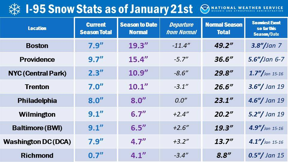
Also, in case anyone is curious about how the 95 corridor big cities are doing, so far, this winter vs. each other and climo, see the table below. NYC doing the worst, well below average, and behind Philly/DC/Balt (which is unusual), all of whom are now at or above avg snowfall to date, although it's still early in the season. Boston and Richmond aren't doing very well either.
@bac2theracAny updates on this one #'s ?
Call me crazy but don't imagine you have to worry about snow.
Call me crazy but don't imagine you have to worry about snow.
Hitting the beach this weekend?🏖️
Call me crazy but don't imagine you have to worry about snow.
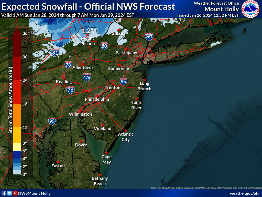
Still looks like mostly rain for 95/coast with rain eventually changing to snow well NW of 95 (esp N of 80) and significant snowfall possible there (4" or more), but even for 95/coast there's a decent possibility of getting 1-2" on the backend (late Sun/early Mon) as cold air works in; more is possible for 95, but unlikely and zero is also quite possible and more likely than getting more than 1-2". Will probably start a thread later today, even if the threat for 95 is low, since there are many posters from NNJ/NEPA/SENY who might still be interested to hear about potential significant snow there. NWS discussion below.Any updates on this one #'s ?
yet he will do one anywayYeah, looking more like a rain event at this point.
I like snow. But at this point, I'd be good with just one solid month of cold snowy weather and done. This year, that month has been January, which is almost over.Don't look now, folks, but we have another snow/mix/rain threat for Sunday afternoon through Monday morning. Most of the models have been mostly misses the past few days, but the potential has been there and today's 12Z models show much more potential for at least a moderate snowfall for most of the area (and rain too), with the Euro showing heavy rain changing to heavy snow with significant snowfall, the CMC showing rain to snow with moderate snow accumulations, but the GFS showing mostly just light rain and the UK showing heavy rain followed by a little bit of back end snow for NYC/NENJ as the low pulls away. If we see more evidence for snowfall after tonight's runs (which will be inside 4 days from the start of the event), will start a thread on it.
As usual, getting snow for the 95 corridor and the coast isn't easy, as timing has to be perfect with respect to the cold air to the north, the track of the coastal low and the degree of phasing of the systems involved wherein we likely need a strong low to generate dynamic cooling aloft and snow, so at this point, it's more likely than not that the 95 corridor/coast gets mostly rain, but there's now at least a modest chance of the rain changing to some accumulating snow. For interior sections (like N and W of the 287/80 intersection and N of 287 in NY), a good hit of snowfall is looking more likely.
Also, in case anyone is curious about how the 95 corridor big cities are doing, so far, this winter vs. each other and climo, see the table below. NYC doing the worst, well below average, and behind Philly/DC/Balt (which is unusual), all of whom are now at or above avg snowfall to date, although it's still early in the season. Boston and Richmond aren't doing very well either.
You realize that if I had power over the weather, we'd be buried in snow from December through March, so no 70s for you in February. Also, February is our snowiest month and there are plenty of mid/long range indications that this February could be stormy/snowy, which is not unusual in an El Nino winter. We'll see...I like snow. But at this point, I'd be good with just one solid month of cold snowy weather and done. This year, that month has been January, which is almost over.
So, time to warm things up such that it's in the mid 70s at daybreak on the weekends until next January. You can have the rest of January for cold and snow. But by Saturday, Feb 3, I expect sunny and mid 70s at day break.
Make it so.
If you had control, you could make be 28F and snow every day at your house, or on your street, or whatever. And then leave everywhere else warm and snow-free.You realize that if I had power over the weather, we'd be buried in snow from December through March, so no 70s for you in February. Also, February is our snowiest month and there are plenty of mid/long range indications that this February could be stormy/snowy, which is not unusual in an El Nino winter. We'll see...
Wrong again, as I'd make it 28F and snow at my house, but make it 0F and blizzard conditions at your house and the houses of everyone else who hates snow, lol.If you had control, you could make be 28F and snow every day at your house, or on your street, or whatever. And then leave everywhere else warm and snow-free.
And don't give me no lip about how that's not possible. Just 'cause nobody's figured out how to do it yet doesn't mean it's impossible. Get it done!
He needs his attention fix.yet he will do one anyway
You're a bad, bad man.Wrong again, as I'd make it 28F and snow at my house, but make it 0F and blizzard conditions at your house and the houses of everyone else who hates snow, lol.
I don’t hate snow or cold weather. I love snow. I just like driving more.Wrong again, as I'd make it 28F and snow at my house, but make it 0F and blizzard conditions at your house and the houses of everyone else who hates snow, lol.
You realize that if I had power over the weather, we'd be buried in snow from December through March, so no 70s for you in February. Also, February is our snowiest month and there are plenty of mid/long range indications that this February could be stormy/snowy, which is not unusual in an El Nino winter. We'll see...
I don’t hate snow or cold weather. I love snow. I just like driving more.
I don’t know if they sponsor or organize such trips. But I would guess various Porsche clubs out there, especially in colder regions of the world, do. They do a ton of harsh winter testing of all their cars.Time for an ice driving trip.
Does Porsche offer those? Seems like it should based on the safari image it's been leaning into the past few years.
Can you finally agree you are wish casting?but the door is at least open a little bit for some snow towards 95.
No, when 2 important models are showing some snow for 95, saying the door is still open for some snow along 95, while recognizing that's an unlikely outcome, is not wishcasting. if all the models were showing all rain for 95 and I was talking about 95 snow, especially this close to the event when major changes are becoming unlikely, then that would be wishcasting.Can you finally agree you are wish casting?
No, when 2 important models are showing some snow for 95, saying the door is still open for some snow along 95, while recognizing that's an unlikely outcome, is not wishcasting. if all the models were showing all rain for 95 and I was talking about 95 snow, especially this close to the event when major changes are becoming unlikely, then that would be wishcasting.
And by the way, we have a thread on one of the greatest forecast busts ever and in that storm, the GFS (the one that's been showing the most snow for the coming storm) was the one model that was consistently predicting much less snow for Jan 2015. And that one busted even after the storm started. Forecasting is still a somewhat uncertain endeavor and I'm sure there will continue to be significant forecast busts.

