
Colleges
- American Athletic
- Atlantic Coast
- Big 12
- Big East
- Big Ten
- Colonial
- Conference USA
- Independents (FBS)
- Junior College
- Mountain West
- Northeast
- Pac-12
- Patriot League
- Pioneer League
- Southeastern
- Sun Belt
- Army
- Charlotte
- East Carolina
- Florida Atlantic
- Memphis
- Navy
- North Texas
- Rice
- South Florida
- Temple
- Tulane
- Tulsa
- UAB
- UTSA
- Boston College
- California
- Clemson
- Duke
- Florida State
- Georgia Tech
- Louisville
- Miami (FL)
- North Carolina
- North Carolina State
- Pittsburgh
- Southern Methodist
- Stanford
- Syracuse
- Virginia
- Virginia Tech
- Wake Forest
- Arizona
- Arizona State
- Baylor
- Brigham Young
- Cincinnati
- Colorado
- Houston
- Iowa State
- Kansas
- Kansas State
- Oklahoma State
- TCU
- Texas Tech
- UCF
- Utah
- West Virginia
- Illinois
- Indiana
- Iowa
- Maryland
- Michigan
- Michigan State
- Minnesota
- Nebraska
- Northwestern
- Ohio State
- Oregon
- Penn State
- Purdue
- Rutgers
- UCLA
- USC
- Washington
- Wisconsin
High Schools
- Illinois HS Sports
- Indiana HS Sports
- Iowa HS Sports
- Kansas HS Sports
- Michigan HS Sports
- Minnesota HS Sports
- Missouri HS Sports
- Nebraska HS Sports
- Oklahoma HS Sports
- Texas HS Hoops
- Texas HS Sports
- Wisconsin HS Sports
- Cincinnati HS Sports
- Delaware
- Maryland HS Sports
- New Jersey HS Hoops
- New Jersey HS Sports
- NYC HS Hoops
- Ohio HS Sports
- Pennsylvania HS Sports
- Virginia HS Sports
- West Virginia HS Sports
ADVERTISEMENT
You are using an out of date browser. It may not display this or other websites correctly.
You should upgrade or use an alternative browser.
You should upgrade or use an alternative browser.
OT: Another Minor/Moderate,Snow Event on Friday (1/19); Still Some Uncertainty
- Thread starter RU848789
- Start date

these amounts will continue to rise in these areas for the next few hours
..New Jersey...
...Atlantic County...
2 WSW Richland 5.0 in 0200 PM 01/19 Public
Mullica Twp 4.0 in 0200 PM 01/19 Trained Spotter
Somers Point 3.0 in 0245 PM 01/19 Broadcast Media
1 NNE Somers Point 2.6 in 0200 PM 01/19 Broadcast Media
Estell Manor 2.0 in 0100 PM 01/19 CO-OP Observer
1 N Hammonton 2.0 in 0100 PM 01/19 CO-OP Observer
Atlantic City International 1.3 in 0100 PM 01/19 ASOS
...Burlington County...
Medford 5.0 in 0211 PM 01/19 Public
Westampton Twp 4.8 in 0300 PM 01/19 Trained Spotter
Palmyra 3.6 in 0315 PM 01/19 Public
Delanco 3.5 in 0230 PM 01/19 Trained Spotter
Delran 3.5 in 0100 PM 01/19 Public
2 NNW South Jersey Regional 3.4 in 0100 PM 01/19 CO-OP Observer
Columbus 3.3 in 0325 PM 01/19 Public
Marlton 3.3 in 0100 PM 01/19 Trained Spotter
Mount Holly WFO 2.9 in 0100 PM 01/19 Official NWS Obs
1 NNE Rancocas 2.9 in 1250 PM 01/19 NWS Employee
Browns Mills 2.5 in 0130 PM 01/19 Public
Leisuretowne 2.1 in 1240 PM 01/19 Trained Spotter
...Camden County...
Cherry Hill 4.3 in 0300 PM 01/19 Public
Haddon Township 3.7 in 0100 PM 01/19 Trained Spotter
1 SSW Pine Hill 3.5 in 0154 PM 01/19 Trained Spotter
1 NNE Gibbsboro 3.5 in 0100 PM 01/19 Public
Cherry Hill 3.4 in 0100 PM 01/19 Public
Lindenwold 3.4 in 1235 PM 01/19 Trained Spotter
1 NNE Stratford 3.3 in 0120 PM 01/19 Trained Spotter
Greentree 3.1 in 0100 PM 01/19 NWS Employee
Haddonfield 3.0 in 0222 PM 01/19 Public
Blackwood 2.5 in 0110 PM 01/19 Public
...Gloucester County...
Gibbstown 5.5 in 0245 PM 01/19 Public
Paulsboro 4.3 in 0311 PM 01/19 Public
Pitman 4.0 in 0130 PM 01/19 Trained Spotter
Woodbury 4.0 in 1245 PM 01/19 Public
Glassboro 3.3 in 0145 PM 01/19 Public
1 SSE Mullica Hill 3.0 in 0140 PM 01/19 Trained Spotter
...Hunterdon County...
Flemington 2.0 in 0225 PM 01/19 Public
...Mercer County...
2 SW Pennington 4.0 in 0250 PM 01/19 Public
Hamilton Square 3.8 in 0200 PM 01/19 Public
2 WNW Allentown 3.5 in 0315 PM 01/19 Public
Lawrenceville 3.3 in 0115 PM 01/19 Trained Spotter
1 N North Princeton 3.2 in 0130 AM 01/19 Trained Spotter
Trenton Mercer Airport 2.8 in 0100 PM 01/19 ASOS
Woodsville 2.8 in 1230 PM 01/19 Trained Spotter
1 NNE Hamilton Square 2.6 in 1230 PM 01/19 Trained Spotter
Hamilton Twp 2.5 in 1220 PM 01/19 Trained Spotter
...Middlesex County...
Cranbury 3.4 in 0230 PM 01/19 Other Federal
East Brunswick 3.0 in 0145 PM 01/19 Trained Spotter
North Brunswick 2.8 in 0123 PM 01/19 Trained Spotter
Highland Park 2.7 in 0257 PM 01/19 Public
Metuchen 2.7 in 0230 PM 01/19 Trained Spotter
Edison 2.6 in 0315 PM 01/19 Newspaper
South Plainfield 1.0 in 0310 PM 01/19 Trained Spotter
...Monmouth County...
Freehold 3.5 in 0325 PM 01/19 Trained Spotter
1 SW Howell 3.0 in 0300 PM 01/19 Trained Spotter
2 SSW Farmingdale 3.0 in 0140 PM 01/19 Public
1 E Perrineville 3.0 in 0130 PM 01/19 Public
1 SSW Freehold 3.0 in 0100 PM 01/19 Trained Spotter
Tinton Falls 1.4 in 0130 PM 01/19 Broadcast Media
...Morris County...
Butler 1.0 in 0315 PM 01/19 Trained Spotter
...Ocean County...
Brick 2.5 in 0205 PM 01/19 Public
2 SE Forked River 2.4 in 0310 PM 01/19 Trained Spotter
Barnegat Twp 2.4 in 0230 PM 01/19 Trained Spotter
Whiting 2.3 in 1236 PM 01/19 Public
Beachwood 2.0 in 0200 PM 01/19 Public
Point Pleasant 2.0 in 0200 PM 01/19 Trained Spotter
Little Egg Harbor Twp 1.0 in 0100 PM 01/19 Trained Spotter
Surf City 0.5 in 1244 PM 01/19 Public
...Somerset County...
Kendall Park 2.5 in 0110 PM 01/19 Public
...Sussex County...
4 WSW Wantage Twp 1.3 in 1200 PM 01/19 T
What’s your band’s name?Thanks, I'm playing at Light of Day tonight
As of about 3:15 pm, the snow was definitely over and my final measurement was 2.8", which turns out to not be that far below my 3.3" prediction around noon yesterday, when the forecast was for 3-6", which I never really bought into since the models were generally showing 2-4" for us, so i went well below what was being forecast at that time. Still a bit on the high side relative to what we got, but then again, my guess is that 5-10 miles north of us most are likely under 2", just based on the radar loop.As of 2:30 pm we hit 2.7", but the snow has gone to light intensity since about 2:25 pm, so not sure if we can squeeze out another 0.3" to get to 3". Still 29F.
Very nice, pretty storm and not too much inconvenience for most, I imagine, at least for shoveling, given how light and fluffy it was - was able to use a wide broom for 90% of it. There were definitely some impacts locally with snow covered local streets and even county roads for an hour or two - numerous fender benders reported, but nothing outrageous.
Brings us to 7.2" on the season, which shouldn't be too far below normal, which is likely about 11" at this point in the season.
Last edited:
Tonight I'm playing with my cover band, Little Jimmy and the Starlites, at the Night of Covers at the Silver Ball Museum (quirky but fun place to play). Shore legend Paul Whistler will be joining us for our set. My original band isn't participating this year.What’s your band’s name?
Sweet! Love Silver Ball - go there a few times a year to play, as I was a pinball addict as a tween, especially as I spent a fair amount of time at Jilly's Arcade on the boardwalk in OCNJ (my dad moved to OC around then when he got remarried). Had no idea they had bands at that location - sounds cool.Tonight I'm playing with my cover band, Little Jimmy and the Starlites, at the Night of Covers at the Silver Ball Museum (quirky but fun place to play). Shore legend Paul Whistler will be joining us for our set. My original band isn't participating this year.
I think they only do it for Light of DaySweet! Love Silver Ball - go there a few times a year to play, as I was a pinball addict as a tween, especially as I spent a fair amount of time at Jilly's Arcade on the boardwalk in OCNJ (my dad moved to OC around then when he got remarried). Had no idea they had bands at that location - sounds cool.
https://www.onlyinyourstate.com/new-jersey/silverball-museum-nj/Great place no doubt.Tonight I'm playing with my cover band, Little Jimmy and the Starlites, at the Night of Covers at the Silver Ball Museum (quirky but fun place to play). Shore legend Paul Whistler will be joining us for our set. My original band isn't participating this year.
Peeps better remove as its getting colder
Make sure you salt..its not going to get above 25 tomorrow
Stay off the side roads to ight as they are icing up quickly
Again the worst part of the storm is the night time ice up
Make sure you salt..its not going to get above 25 tomorrow
Stay off the side roads to ight as they are icing up quickly
Again the worst part of the storm is the night time ice up
In Howell, I'd say 3" to 3.5" is pretty accurate. Did get the snowblower ready @Knight Shift but don't think I'll be using it. Directions were drawn by a 5 yr. old however, was pretty sedate this morning, so no Olympic records were broken in the tool toss event. I will say, I can't get my dogs in, every time I go out to get them, they take off into the pastures. With all the hair, they're now 100 lb snowballs.
Last edited:
In Howell, I'd say 3" to 3.5" is pretty accurate. Did get the snowblower ready @Knight Shift but don't think I'll be using it. Directions were drawn by a 5 yr. old but was pretty sedate this morning, so no Olympic records were broken in the tool toss event. I will say I can't get my dogs in, every time I go out to get them, they take off into the pastures. With all the hair, they're now 100 lb snowballs.
Some dogs just LOVE the snow.
Here in Cherry Hill, I cleared a lot of snow off the car at about 2:30. I went back out at 4:30 and there was plenty of new snow on the car. The concrete driveway and walkways are snow-covered. Maybe this was a bust elsewhere, but certainly this was a real storm in Philly's South Jersey suburbs. As @bac2therac says, it will be cold tomorrow, so I figured it made sense to do what I could today.We are at 6" in Cherry hill (includes some left over from earlier in the week). Still coming down but not as hard as it was an hour ago.
Zero accumulation in Morristown and surrounding areas.i pretty much nailed this event for most of nj...so great
1-4 with some patches of higher in the banding that was highly unpredictable and less than 1 up in parts of nw nj
and the lack of snowfall on treated surfaces even in the hardest hit areas makes it a minor event
There really shouldn't be much icing up, except where salt was used and melted some snow which could then refreeze. Roads right now are as good as they've been and were much worse earlier today, at least anywhere that snow was falling heavily and roads were snow covered with poor visibility. To call tonight the worst part of the storm is simply inaccurate. Sounds like you're trying to drum up plowing and salting business.Peeps better remove as its getting colder
Make sure you salt..its not going to get above 25 tomorrow
Stay off the side roads to ight as they are icing up quickly
Again the worst part of the storm is the night time ice up
Also, temps have been well below 32F for all but folks at the coast and will continue to drop, so there will be no "icing up" of snow on the ground as long as salt isn't used, as icing up requires melting first and there will be no melting of consequence unless salt is used or until Monday when temps finally go back above 32F. So nobody's snow on their driveway or sidewalk will be melting and refreezing if they don't use any salt, although having said that people are supposed to clear their sidewalks for pedestrians.
I would actually refrain from putting salt down on driveways and sidewalks unless one left some snow on them or if they compressed the snow (tire tracks for example, which can be hard to remove later), but with how easily moved the snow was that really shouldn't be an issue.
Zero accumulation in Morristown and surrounding areas.
Morris County... 2 NNE Brookside 1.3 in 0400 PM 01/19 Trained Spotter Butler 1.0 in 0315 PM 01/19 Trained Spotter Pompton Plains 0.8 in 0513 PM 01/19 Public
There really shouldn't be much icing up, except where salt was used and melted some snow which could then refreeze. Roads right now are as good as they've been and were much worse earlier today, at least anywhere that snow was falling heavily and roads were snow covered with poor visibility. To call tonight the worst part of the storm is simply inaccurate. Sounds like you're trying to drum up plowing and salting business.
Also, temps have been well below 32F for all but folks at the coast and will continue to drop, so there will be no "icing up" of snow on the ground as long as salt isn't used, as icing up requires melting first and there will be no melting of consequence unless salt is used or until Monday when temps finally go back above 32F. So nobody's snow on their driveway or sidewalk will be melting and refreezing if they don't use any salt, although having said that people are supposed to clear their sidewalks for pedestrians.
I would actually refrain from putting salt down on driveways and sidewalks unless one left some snow on them or if they compressed the snow (tire tracks for example, which can be hard to remove later), but with how easily moved the snow was that really shouldn't be an issue.
Wrong...because stuff is freezing up after the snow stopped...all around i. My area went from wet to icy
We have receipts
Wow dont give us snow removal advice
You should start a snow removal thread. 😉Wrong...because stuff is freezing up after the snow stopped...all around i. My area went from wet to icy
We have receipts
Wow dont give us snow removal advice
Went out about 20 minutes ago. Once it got dark and lost the radiative heat of the sun from behind the clouds, snow started sticking again. Mostly done. Took a measurement in the grass, and had 4.75"In Howell, I'd say 3" to 3.5" is pretty accurate. Did get the snowblower ready @Knight Shift but don't think I'll be using it. Directions were drawn by a 5 yr. old however, was pretty sedate this morning, so no Olympic records were broken in the tool toss event. I will say, I can't get my dogs in, every time I go out to get them, they take off into the pastures. With all the hair, they're now 100 lb snowballs.
The salt they are putting down currently in my area roads are melting the ice that formed after 330 when the snow stopped
Salt is your friend right now
The worst part of the storm is the icing tonight
Salt is your friend right now
The worst part of the storm is the icing tonight
I think this freeze won’t be as bad as Tuesday into Wednesday because we didn’t have that extended period of freezing drizzle - at least by me.
Yes exactly. Hardly covered by the on board Master but I posted it was raining at 7:30 in Philadelphia and it never returned back to snow. And it was 29 degrees on the ground level but warmer above.I think this freeze won’t be as bad as Tuesday into Wednesday because we didn’t have that extended period of freezing drizzle - at least by me.
Woodstown. Your area is the 4th Region of NJ behind North, Central and South Jersey. Delaware East or Delaware Bay region. Beautiful area! And yes you guys were in the slot of heavy snows longer then most.Woodstown.. somewhere between 5 and 6 inches of light fluffy stuff. Driving home from work this evening was super sketchy!
Of course it's going to get icy on the roads which were salted, as that leads to melting/slush, which will refreeze if no fresh salt is added. I was never talking about that. I just got back in from doing a takeout run to South Plainfield via county roads and as I know you know, properly salted, those roads are fine right now, but some of the unsalted side roads that have been compressed by traffic (adds heat and melts some of the snow which refreezes) are very icy and really need salt.Wrong...because stuff is freezing up after the snow stopped...all around i. My area went from wet to icy
We have receipts
Wow dont give us snow removal advice
I was talking about regular folks and their driveways and sidewalks. For them, there is zero need to put salt down, as they can easily broom/shovel this light, fluffy snow, leaving no residual and even if someone doesn't shovel it won't be an issue...as long as there was no salt on it to begin with or as long as it wasn't compressed significantly. Light fluffy snow left on a driveway or sidewalk well below 32F just won't be an issue - one could shovel it tomorrow and not have an issue other than with one's neighbors (for a sidewalk).
Do you really want to get into a physical chemistry argument with me? Didn't think so.
Weather gurus, any idea what the severity of the snow is coming Tuesday in Syracuse is?
I’ll be driving from Albany to Syracuse on Tuesday morning for meetings, and wanted to get a gauge
I’ll be driving from Albany to Syracuse on Tuesday morning for meetings, and wanted to get a gauge
Looks like light snow for much of the day, amounting to just an inch or two and with temps around 32F, I can't imagine crews up there not being able to deal with this to keep the highways in good shape - probably child's play for them, lol. Snow will likely change to rain late that night. Good luck.Weather gurus, any idea what the severity of the snow is coming Tuesday in Syracuse is?
I’ll be driving from Albany to Syracuse on Tuesday morning for meetings, and wanted to get a gauge
https://www.weather.gov/bgm/
Some driveways that I plowed Tuesday were completely just wet at 4pm. When we went by again at 6 there was a thin glaze of ice that when the snow stopped at 4 everything wet just froze. As Frankenstein said...salt gooood. Anywho the driveways that got salted will just dry up overnight so i don't have to get up at 4am to salt. I don't need a chemistry degree for that.
Of course it's going to get icy on the roads which were salted, as that leads to melting/slush, which will refreeze if no fresh salt is added. I was never talking about that. I just got back in from doing a takeout run to South Plainfield via county roads and as I know you know, properly salted, those roads are fine right now, but some of the unsalted side roads that have been compressed by traffic (adds heat and melts some of the snow which refreezes) are very icy and really need salt.
I was talking about regular folks and their driveways and sidewalks. For them, there is zero need to put salt down, as they can easily broom/shovel this light, fluffy snow, leaving no residual and even if someone doesn't shovel it won't be an issue...as long as there was no salt on it to begin with or as long as it wasn't compressed significantly. Light fluffy snow left on a driveway or sidewalk well below 32F just won't be an issue - one could shovel it tomorrow and not have an issue other than with one's neighbors (for a sidewalk).
Do you really want to get into a physical chemistry argument with me? Didn't think so.
Cars that werent brushed off this afternoon have ice underneath them
Sidewalks after sweeping need salt to remove the residual snow which isnt going anyway tomorrow
Used the salt and it made everything wet which will dry without refreezing overnight
I dont give a shit about chemistry
You're kidding right? Below is just a sampling of my posts on the freezing rain threat, which the NAM caught onto well before all of the other models, held steady on it and ended up being pretty damn close on amounts and general locations for the freezing rain that fell, which obviously informed people of the impacts that could result. And for the record, bac completely dismissed the NAM and the freezing rain threat, as per his post below.Yes exactly. Hardly covered by the on board Master but I posted it was raining at 7:30 in Philadelphia and it never returned back to snow. And it was 29 degrees on the ground level but warmer above.
I also offered up a number of tips on how to handle freezing rain with regard to when to shovel: after it all fell, so it could be removed as one wet snow mass, but before 6-7 pm when temps were supposed to start dropping well below 32F, which could make for a big frozen mass, as well as discussing potential impacts on the roads. I even addressed the threat of ZR in the Philly region in response to @retired711's questions on that.
A few things to keep in mind and I'll use the 0Z NAM, which just came out to illustrate. The NAM and RGEM, which often do better with modeling warm air aloft, which leads to sleet or freezing rain if the surface is below 32F (freezing rain if it's a shallow sub-32F layer near the surface and sleet if that cold layer is much deeper), are showing the snow changing to freezing rain right around rush hour on Tuesday along 95 (plain rain SE of there) and just NW of 95, with up to 0.1" or so of freezing rain possible.
It's bad enough there could be a glaze on top of the snow or even areas that have been cleared making them very icy, but the other thing this could do is lead to the snowpack becoming somewhat wet, such that the whole mass would freeze solid by late afternoon as temps drop, so shoveling before dark would be a good thing to do; same thing for areas SE of 95 that are modeled to turn to rain (where that wet snowpack would freeze solid) and anything that freezes solid Tuesday afternoon will stay that way through about Sunday with slow melting as temps might not go above 32F again until then.
That's If all of this verifies. Note that the NWS is still not calling for freezing rain, officially (but they do mention the possibility in their discussion), likely because none of the global models is showing any freezing rain, so the preceding is still mostly hypothetical, but possible.
One more thing to keep in mind is that snow:liquid ratios are possibly going to be >10:1 in areas where the whole atmospheric column is at least a few degrees below 32F and that's likely most locations, at least before about 7 am, when temps are pretty cold. Cold columns can help retain well grown dendrites, which are fluffy, but dendrite growth is controlled ~15K feet up by lift and saturation levels. Anyway, many like to use the Kuchera ratio for snow depth - you can see how it is greater the further NW one goes. Personally, I like using 10:1, if only so one then knows exactly how much precip is falling and the overall frozen snow mass.


Yep, start time keeps moving up. Cherry Hill will likely start by 6-7 pm with accumulating snow (maybe some very light snow before that) and will largely be done with precip by 9-10 am or so, but 80-90% of that is going to be snow, with rain and/or maybe freezing rain likely only coming in after 6-7 am (if it does - only some models show that). You're going to have snow covered roads and the morning rush will likely be difficult.
So, the NWS upped snowfall amounts again, based on the uptick in snowfall on the models, with the advisories generally for 3-5" along and NW of 95 in EPA/NJ, north of 276/195 that's what the advisories say even though the map shows 4-6" - the next "color" is 3-4", so they had to pick one), with 2-4" south of there and SE of 95, except only 1-2" in far SENJ as per the updated map below. NWS-NYC updated map not out yet, but their advisories for NENJ (Union up to Bergen) and NYC/LI are for 2-4", so a little less than NJ/PA NW of 95 and N of 276/195. These are pretty minor differences and it's easily possible the max amounts are in NENJ or NYC.
Also, we'll see some light snow before 9-10 pm in CNJ, but it's likely we won't start seeing accumulations until after that. In addition, the NWS thinks there could be a change to sleet/freezing rain along the 95 corridor and probably even rain for coastal sections (hold accumulations down there) after about 9-10 am for a few hours, but that's not a given. Freezing rain would not be welcome, although it's better on top of snow than on top of bare pavement. Somewhere NW of 95, like Morris/Sussex/Passaic etc. might get to 5-6" if we see really fluffy ratios, which is possible where there is no mixing and they get good snow growth.
Still going with 3.2" for my house which is what I posted this morning, so I have to stick with it, but now thinking 4" is more likely given the updated forecasts and snowier models. We'll see soon.
https://forecast.weather.gov/wwamap/wwatxtget.php?cwa=PHI&wwa=winter weather advisory
Edit: NWS-NYC finally updated their map, below, also increasing snowfall amounts to 4-5" NW of the Parkway in NENJ and to 3-4" for east of the Parkway and NYC/LI.


NAM and RGEM have consistently shown that freezing rain risk after about 9 am or so, but the globals either have all snow for 95 or a later changover to sleet or freezing rain. Agree we don't want freezing rain, as it's dangerous and aesthetically unpleasing. Saving grace could be that it'll mostly be falling on top of snow, forming a crust and not falling on bare ground forming ice rinks. Here's the difference between the NAM and Euro on freezing rain (ZR), which is substantial. If the NAM verified, that's 1-2" of snowfall lost to ZR and a risk of serious icing. Let's hope it's wrong.
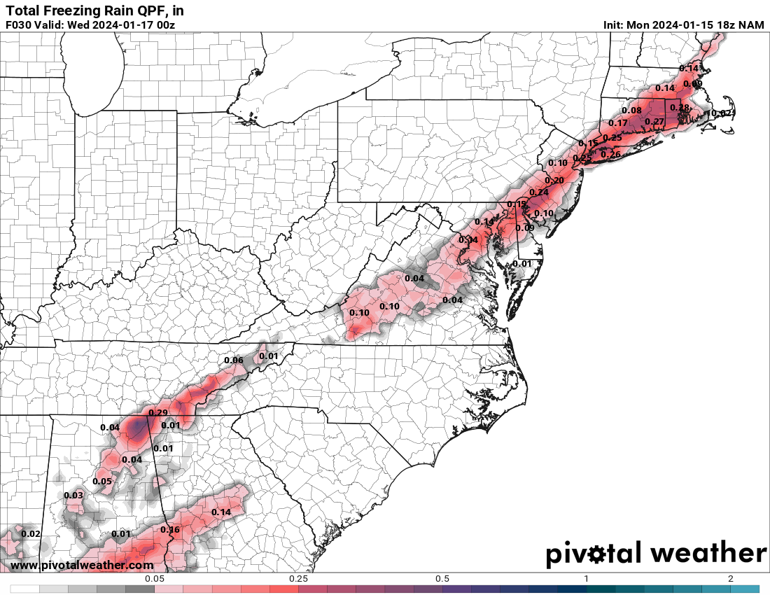
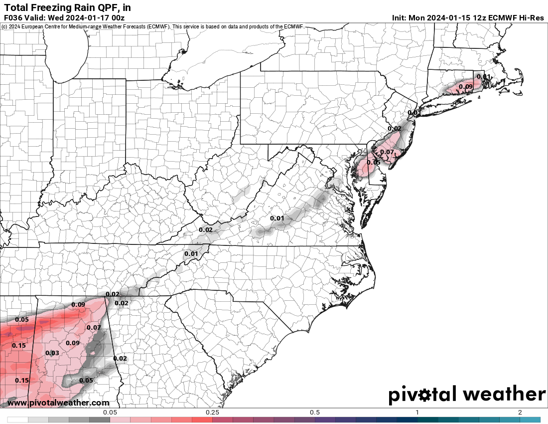
Nobody wants the new 0Z NAM to verify. For most of the 95 corridor from Philly to NYC it shows ~3" of snow, followed by about 0.25-0.4" of freezing rain - even if only some of that accretes on surfaces, that could be a significant ice storm on top of the snow, plus it robs us of about another 3" or so of snow. 4-5' of snow fall 10+ miles NW of 95 and beyond where they don't see ZR. But the NAM has been showing ZR for several runs in a row along the 95 corridor, so hard to just dismiss it.
The NAM will be wrong but wouldn't be surprised to see a touch of freezing drizzle at the end
Even if we get rain (not a given temps go above 32F along/NW of 95 - they likely will SE of 95 and definitely will near/along the coast), it's not going to melt anything with temps in the low 30s - that rain will simply be absorbed into the snow and freeze solid if you don't shovel it before sunset. The flip side is that if there's appreciable freezing rain, you might want to wait until that's over before shoveling as it wouldn't be great to shovel, exposing cold surfaces to the freezing rain and then having a glaze on your driveway/sidewalk. Personally, I'm waiting until about noon for that reason, but I have that luxury.
Edit - just saw you said you're in Freehold and you likely won't get much freezing rain, so shoveling now should be fine. And with ~2.5", as I said, any rain you get won't melt the snow - it'll just make it wetter/slushier. Whatever you do, don't wait until after sunset, as it's likely not going to get above 32F again until Monday.
Assuming you're in a mix area, here's what I kind of posted earlier, but summarized better (just posted elsewhere)...
In the Edison area, we expect sleet for the next hour or so and then probably freezing rain for an hour or two until the precip is over in the early afternoon.
Two pieces of advice. If you have the option, waiting to shovel until the end of the precip is probably best, since if one shovels now it could lead to a glaze from freezing rain falling on freshly shoveled driveways and sidewalks. Personally, I'm going to wait until after about 1 pm to shovel to avoid this risk, since freezing rain falling on fairly dry snow will just make the snow wetter (and we won't get anywhere near enough freezing rain to melt the snow).
Second thing is that people should absolutely shovel by about 5-6 pm at the latest, since temps, which will eventually get to about 32-33F in town in the afternoon, will be below 32F by sunset and will drop quickly after that (will be down to 25F by 8 pm), freezing solid the wet, slushy snow on paved surfaces - and it may not get above 32F until Monday.
Score a huge win for the NAM and the RGEM the two major mesoscale/regional models, as both models have been calling for significant freezing rain (ZR) since Sunday morning and generally weren't joined by the global models in predicting appreciable ZR until Monday morning or afternoon.
Appreciate it. Thank you, looks like it’ll be more of annoyance driving on the Thruway.Looks like light snow for much of the day, amounting to just an inch or two and with temps around 32F, I can't imagine crews up there not being able to deal with this to keep the highways in good shape - probably child's play for them, lol. Snow will likely change to rain late that night. Good luck.
https://www.weather.gov/bgm/
Holy shyte. You went through all that trouble to beat your chest? Isn't there a snow angel that has to be made?You're kidding right? Below is just a sampling of my posts on the freezing rain threat, which the NAM caught onto well before all of the other models, held steady on it and ended up being pretty damn close on amounts and general locations for the freezing rain that fell, which obviously informed people of the impacts that could result. And for the record, bac completely dismissed the NAM and the freezing rain threat, as per his post below.
I also offered up a number of tips on how to handle freezing rain with regard to when to shovel: after it all fell, so it could be removed as one wet snow mass, but before 6-7 pm when temps were supposed to start dropping well below 32F, which could make for a big frozen mass, as well as discussing potential impacts on the roads. I even addressed the threat of ZR in the Philly region in response to @retired711's questions on that.
Still trying to figure out if this is bac or his brother Rock, but anyway, Tuesday and today were completely different storms and what you did on Tuesday was 100% correct - salt was everyone's friend with wet, slushy snow everywhere from the snow that fell, plus the freezing rain that fell on top of it, that was sitting there ready to freeze solid on any surface that wasn't shoveled, plowed or salted.Some driveways that I plowed Tuesday were completely just wet at 4pm. When we went by again at 6 there was a thin glaze of ice that when the snow stopped at 4 everything wet just froze. As Frankenstein said...salt gooood. Anywho the driveways that got salted will just dry up overnight so i don't have to get up at 4am to salt. I don't need a chemistry degree for that.
Today's storm had zero risk of ice formation, except where salt was already used, since temps never went above 32F (either at the surface or aloft, forming ZR as occurred on Tuesday), so salt was only really needed for areas where salt was used before. I used some salt on my driveway/sidewalk after shoveling to make sure the bits of slush and continuing freezing rain didn't ice up, while I didn't use any salt today and my driveway and sidewalk are nearly pristine. Maybe if you knew something about chemistry you'd stop using a hammer when you don't have a nail.
No, I went through that to illustrate to WB that maybe he should read the threads before he posts. Took all of 2-3 minutes.Holy shyte. You went through all that trouble to beat your chest? Isn't there a snow angel that has to be made?
Holy shyte. You went through all that trouble to beat your chest? Isn't there a snow angel that has to be made?
He sounds drunk
We were only talking about the freezing rain risk at that point and you know it. You said, "The NAM will be wrong but wouldn't be surprised to see a touch of freezing drizzle at the end," which essentially says there would be nearly zero ZR during the main part of the storm as there was for many of us with nearly half the total precip falling as ZR, not just "a touch at the end." It's ok to admit you were wrong. I was wrong about NW of 95 staying almost all snow and getting 4-6", when almost everyone, even up past 80 changed over, causing even those areas to only hit 2-4". It happens. It's good for the soul to acknowledge and learn from one's mistakes.The nam was wrong on snow amounts...3-5 inches which didnt happen and we got freezing drizzle at the end
You do snow ignore the rest.You're kidding right? Below is just a sampling of my posts on the freezing rain threat, which the NAM caught onto well before all of the other models, held steady on it and ended up being pretty damn close on amounts and general locations for the freezing rain that fell, which obviously informed people of the impacts that could result. And for the record, bac completely dismissed the NAM and the freezing rain threat, as per his post below.
I also offered up a number of tips on how to handle freezing rain with regard to when to shovel: after it all fell, so it could be removed as one wet snow mass, but before 6-7 pm when temps were supposed to start dropping well below 32F, which could make for a big frozen mass, as well as discussing potential impacts on the roads. I even addressed the threat of ZR in the Philly region in response to @retired711's questions on that.
Are you being willfully ignorant or are you just trolling for sport?You do snow ignore the rest.
Wrong...because stuff is freezing up after the snow stopped...all around i. My area went from wet to icy
We have receipts
Wow dont give us snow removal advice
You had to expect a correction.
Similar threads
- Replies
- 472
- Views
- 18K
- Replies
- 131
- Views
- 5K
- Replies
- 152
- Views
- 7K
- Replies
- 74
- Views
- 2K
ADVERTISEMENT
Latest posts
-
 Podcast Rutgers Re-Hires Robb Smith as Co-DC and We Have....Thoughts
- Latest: William J. Leggett
-

-
-
-

ADVERTISEMENT