ADVERTISEMENT

OT: Another Minor/Moderate,Snow Event on Friday (1/19); Still Some Uncertainty

Cars that werent brushed off this afternoon have ice underneath them

Sidewalks after sweeping need salt to remove the residual snow which isnt going anyway tomorrow

Used the salt and it made everything wet which will dry without refreezing overnight

I dont give a shit about chemistry

Hee hee hee back to chemistry? LOL
 
  • Like
Reactions: bac2therac
As of about 3:15 pm, the snow was definitely over and my final measurement was 2.8", which turns out to not be that far below my 3.3" prediction around noon yesterday, when the forecast was for 3-6", which I never really bought into since the models were generally showing 2-4" for us, so i went well below what was being forecast at that time. Still a bit on the high side relative to what we got, but then again, my guess is that 5-10 miles north of us most are likely under 2", just based on the radar loop.

Very nice, pretty storm and not too much inconvenience for most, I imagine, at least for shoveling, given how light and fluffy it was - was able to use a wide broom for 90% of it. There were definitely some impacts locally with snow covered local streets and even county roads for an hour or two - numerous fender benders reported, but nothing outrageous.

Brings us to 7.2" on the season, which shouldn't be too far below normal, which is likely about 11" at this point in the season.
Forgot to post this. After shoveling then relaxing some, I went back outside to go run some errands and we had about 0.1" of new snow on the board, cars, etc., which must've fallen after dark, so my total is now up to 2.9" and our season total is up to 7.3". Driving around Metuchen, Edison and South Plainfield, all of the county roads seemed to be in good shape, but some of the lightly traveled residential streets were icy in spots, so be careful out there. Temp down to 27F.

I also calculated my snow:liquid ratio for the first time ever (used a roughly 11x11" square section I melted down) got 17.6" of snow per 1" of liquid. I was guessing it was around 15-17, so 17.6 is believable. That means I only had 0.16" of liquid equivalent per 2.9" of snow depth. Just imagine if we had gotten the 0.3-0.4" of precipitation we were looking at on some models 2 days ago and had those ratios - would've been at least 6" of snow on the ground. Damn.

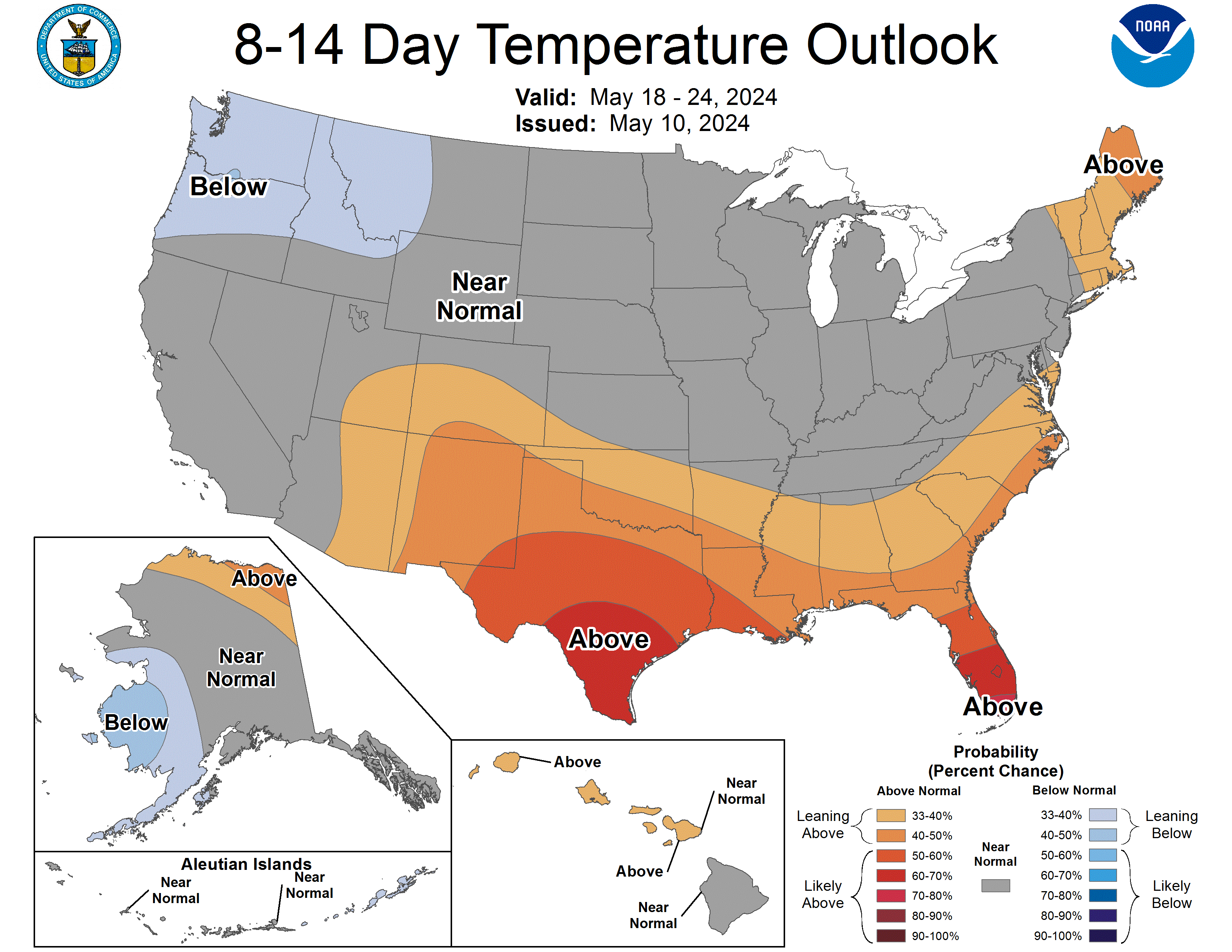
And for those of you who have had enough of snow and cold, things warm up a fair amount this coming week and then look to get quite warm for late next week through the following week, with snow very unlikely. Long range models then indicate some chance for a return to the active/colder-than-normal regime we've been in for awhile, but that's pretty far out and nowhere near set in stone. We'll see...

814temp.new.gif
 
Last edited:
  • Like
Reactions: Plum Street
Are you being willfully ignorant or are you just trolling for sport?
Are you serious? Snow lover who still hasn't answered my question from this morning. Instead you ignored it and post crap. You are the troll. Trying to say I can't measure snow but when was the last time you have been to Philadelphia? I take your measurements from you home as fact but you blast me in by my measuring in Philly. You have no idea how big Philadelphia is. But you do know that 3/4 of the official weather station at the Airport is in Delaware County as we have had this conversation before. Yet you bring it up today knowing it's not Philadelphia. You are the ignorant one, blinded by the bust you predicted.
 
Are you serious? Snow lover who still hasn't answered my question from this morning. Instead you ignored it and post crap. You are the troll. Trying to say I can't measure snow but when was the last time you have been to Philadelphia? I take your measurements from you home as fact but you blast me in by my measuring in Philly. You have no idea how big Philadelphia is. But you do know that 3/4 of the official weather station at the Airport is in Delaware County as we have had this conversation before. Yet you bring it up today knowing it's not Philadelphia. You are the ignorant one, blinded by the bust you predicted.
I addressed your lame attempt to paint me as someone who only posts about snow and not freezing rain, which didn't reference any earlier post and you haven't responded to my post on that which clearly proves I was very active posting about freezing rain risks before, during and after the last storm. I also have no idea why you're so wound up about the post on Philly snowfall, now. I thought I was gently busting chops given our past history on measurements there and you now seem to be very angry about that, but weren't afterwards, joking about me needing a map. I had zero issue with your measurement. My only point, which remains, was that there were other locations in Philly that had more (and I think you're in the NE iirc) and that point still remains, although there's always variability across a large city like Philly, as per the numbers below.

And you keep mentioning some question, but I don't even remember that and didn't see it in the posts I looked at - maybe you could refresh my memory, as I probably read a few thousand posts today and made several hundred across 4 message boards, 2 FB sites, and some replies and answers to questions from the hundreds of folks on my weather emails. So forgive me if I can't remember or find it, as I'm running on fumes right now.

...Philadelphia County...
1 WSW Belmont 5.9 in 0350 PM 01/19 Public
Philadelphia 5.0 in 0353 PM 01/19 Public
Shawmont 4.8 in 0535 PM 01/19 Public
1 NNW Northeast Philadelphia 4.7 in 0729 PM 01/19 Trained Spotter
Philadelphia International A 4.6 in 0700 PM 01/19 ASOS
1 SE Center City 4.3 in 0420 PM 01/19 Trained Spotter
Fox Chase 4.3 in 0600 PM 01/19 Public
 
  • Like
Reactions: RU#1fan
Hee hee hee back to chemistry? LOL
I see they let the new troll back in the thread. Enjoying yourself making catty, comments that an 8-year old might make? All that education and this is the best you can do? I know you're capable of a lot more - maybe try to live up to that rather than living down to the level of the regular trolls in these threads. Your call.
 
+1
We essentially have nothing here. Absolutely nothing. The roads, sidewalks, and driveways are clear. But the schools are closed thanks to Murphy and Mount Holly.
And yet, the NWS 3-5" forecast for southern Somerset essentially verified after all. Once again we catch T in a lie about snow. No surprise. Lying on top of trolling. I can see now how important those skills must have been for you in advancing your political career - thinking of making a run at Murphy?

...Somerset County...
Belle Mead 3.5 in 0412 PM 01/19 Trained Spotter
2 ENE Montgomery Twp 2.9 in 0500 PM 01/19 Trained Spotter
 
I was a casualty of the latest storm. Coming out of the parking lot of Buffalo Wild Wings in Woodbrige after a night with friends, my car slid, hit the curb. Busted front driver control arm, $600 to fix. Hate snow and the wings were pretty bad too.
 
And yet, the NWS 3-5" forecast for southern Somerset essentially verified after all. Once again we catch T in a lie about snow. No surprise. Lying on top of trolling. I can see now how important those skills must have been for you in advancing your political career - thinking of making a run at Murphy?

...Somerset County...
Belle Mead 3.5 in 0412 PM 01/19 Trained Spotter
2 ENE Montgomery Twp 2.9 in 0500 PM 01/19 Trained Spotter
Nope, nothing on roads, sidewalks, or driveways. Barely had to dust off the cars. Sorry, I know the truth hurts. Feel free to drive over to town tomorrow since you care so much.

LOL!
 
Happy to report that after clearing driveways/walks and putting down salt/calcium chloride to melt the residual ice /snow everything is clear to the bone. Who knew? Salt does work overnight.
 
  • Like
Reactions: MulletCork
18" of fresh windblown snow in the driveway up here above Boone NC. Not sure yet as to how much actually fell, per the drifting effect. Will head out just a bit later to assess and clear what I can. Temp currently 1°. No wind at the moment, which is odd. But it'll pick up, for sure. Supposedly snow showers thru late afternoon. High of 10. A warming trend visits Wednesday, with highs in the 50s. We need a good thaw... and a break from the white stuff.
 
...New Jersey...

...Atlantic County...
Dorothy 6.4 in 0926 AM 01/20 Public
2 W Atlantic City 6.0 in 0728 PM 01/19 Public
Mullica Twp 5.6 in 0535 PM 01/19 Trained Spotter
Mays Landing 5.5 in 0550 PM 01/19 Public
1 NW Somers Point 5.2 in 0929 PM 01/19 Cocorahs
Somers Point 0.2 NW 5.2 in 0630 AM 01/20 COCORAHS
2 WSW Richland 5.0 in 0200 PM 01/19 Public
1 S Atlantic City 5.0 in 0633 PM 01/19 Public
Absecon 5.0 in 0726 PM 01/19 Broadcast Media
Estell Manor 4.0 WNW 5.0 in 0800 AM 01/20 COCORAHS
Estell Manor 4.9 in 0830 PM 01/19 CO-OP Observer
Buena Vista Twp 2.6 NNE 4.8 in 0700 AM 01/20 COCORAHS
Atlantic City International 4.6 in 0700 PM 01/19 ASOS
1 N Hammonton 4.5 in 0500 PM 01/19 CO-OP Observer
Galloway Twp 4.5 in 0926 AM 01/20 Public
Egg Harbor Twp. 4.4 in 0340 PM 01/19 Emergency Mngr
1 WNW Hammonton 4.3 in 0518 PM 01/19 Cocorahs
Smithville 4.3 in 0825 PM 01/19 Broadcast Media
3 E Mullica Twp 4.2 in 0700 AM 01/20 COCORAHS
Estell Manor 4.2 in 0800 AM 01/20 COOP
Brigantine 0.9 ESE 4.1 in 0700 AM 01/20 COCORAHS
Galloway Twp 2.9 SW 3.7 in 0700 AM 01/20 COCORAHS
Galloway 0.9 E 3.6 in 1020 PM 01/19 COCORAHS
Pomona 3.0 in 0200 PM 01/19 Broadcast Media
Somers Point 3.0 in 0245 PM 01/19 Broadcast Media
Brigantine 0.4 ESE 3.0 in 0700 AM 01/20 COCORAHS
Ventnor City 2.6 in 0200 PM 01/19 Broadcast Media
1 NNE Somers Point 2.6 in 0200 PM 01/19 Broadcast Media
Hammonton 2.0 in 1254 PM 01/19 Public

...Burlington County...
Medford Twp. 6.1 in 0718 PM 01/19 Trained Spotter
Mount Laurel 6.0 in 0530 PM 01/19 Trained Spotter
Moorestown 6.0 in 0616 PM 01/19 Trained Spotter
Tabernacle 6.0 in 0934 PM 01/19 Public
Medford Lakes 5.9 in 0614 PM 01/19 Public
Moorestown Twp 5.5 in 0515 PM 01/19 Trained Spotter
Medford 5.5 in 0530 PM 01/19 Public
Lake Pine 5.5 in 0600 PM 01/19 Trained Spotter
Burlington Twp 5.5 in 1112 PM 01/19 Trained Spotter
Marlton 5.3 in 0530 PM 01/19 Trained Spotter
2 WSW Lake Pine 5.3 in 1046 PM 01/19 Public
Westampton Twp 5.2 in 0500 PM 01/19 Trained Spotter
Leisuretowne 5.1 in 0720 PM 01/19 Trained Spotter
2 NNW South Jersey Regional 5.0 in 0545 PM 01/19 CO-OP Observer
Evesham Twp 5.0 in 0651 PM 01/19 Trained Spotter
Mount Holly WFO 4.8 in 0700 PM 01/19 Official NWS Obs
1 ESE Riverside 4.8 in 0830 PM 01/19 Public
Evesham 4.2 S 4.8 in 0730 AM 01/20 COCORAHS
Palmyra 4.8 in 0545 PM 01/19 Public
1 NNE Rancocas 4.7 in 1107 PM 01/19 NWS Employee
Westampton 4.7 in 0700 AM 01/20 COOP
Mount Laurel 4.7 in 0700 AM 01/20 COCORAHS
Medford Lakes 4.5 in 0845 AM 01/20 COCORAHS
2 NW South Jersey Regional A 4.3 in 0544 PM 01/19 NWS Employee
Delanco 4.1 in 0530 PM 01/19 Trained Spotter
Delran 4.0 in 0554 PM 01/19 Public
Browns Mills 4.0 in 0605 PM 01/19 Public
Columbus 4.0 in 0624 PM 01/19 Trained Spotter
Mansfield Twp 1.9 SW 4.0 in 0700 AM 01/20 COCORAHS
1 NNE Burlington Twp 3.8 in 0355 PM 01/19 NWS Employee
Columbus 3.3 in 0325 PM 01/19 Public
1 NNE Rancocas 2.9 in 1250 PM 01/19 NWS Employee

...Camden County...
Barrington 0.8 NE 6.2 in 0700 AM 01/20 COCORAHS
Berlin 6.0 in 0900 PM 01/19 Public
Blackwood 5.8 in 0545 PM 01/19 Public
Magnolia 5.5 in 0550 PM 01/19 Public
Lindenwold 5.5 in 0630 PM 01/19 Trained Spotter
Mount Ephraim 5.5 in 0650 AM 01/20 COCORAHS
Greentree 5.4 in 0700 PM 01/19 NWS Employee
Haddon Township 5.3 in 0630 PM 01/19 Trained Spotter
1 W Cherry Hill Twp 5.1 in 0718 PM 01/19 Public
1 NNE Gibbsboro 5.0 in 0345 PM 01/19 Public
1 ENE Winslow Twp 5.0 in 0400 PM 01/19 Amateur Radio
Cherry Hill 5.0 in 0500 PM 01/19 Public
2 NNW Winslow Twp 5.0 in 0700 PM 01/19 Amateur Radio
Bellmawr 5.0 in 0700 PM 01/19 Trained Spotter
1 NNE Stratford 4.9 in 0430 PM 01/19 Trained Spotter
Atco 4.8 in 0700 PM 01/19 Amateur Radio
1 SSW Pine Hill 4.5 in 0700 PM 01/19 Trained Spotter
Cherry Hill Twp 1.6 WNW 4.5 in 0700 AM 01/20 COCORAHS
2 SW Chesilhurst 4.0 in 0400 PM 01/19 Amateur Radio
Winslow Twp. 3.5 W 3.5 in 0700 AM 01/20 COCORAHS
Haddonfield 3.0 in 0222 PM 01/19 Public

...Cape May County...
Dennisville 4.9 in 0500 PM 01/19 Trained Spotter
Seaville 4.5 in 0500 PM 01/19 Trained Spotter
2 NNE Strathmere 4.5 in 0520 PM 01/19 Trained Spotter
Ocean City 4.4 in 0726 PM 01/19 Broadcast Media
Wildwood 4.0 in 0400 PM 01/19 Trained Spotter
Woodbine 0.8 NW 4.0 in 0700 AM 01/20 COCORAHS
2 NW Cape May 3.2 in 0820 PM 01/19 CO-OP Observer
1 SSW Cape May Court House 3.0 in 0450 PM 01/19 Trained Spotter
4 NW Avalon 3.0 in 0648 PM 01/19 Trained Spotter
1 SE Green Creek 3.0 in 0649 PM 01/19 Trained Spotter
Ocean City 1.6 SW 3.0 in 0700 AM 01/20 COCORAHS
Lower Twp 1.3 ENE 3.0 in 0700 AM 01/20 COCORAHS
Wildwood Crest 3.0 in 0730 AM 01/20 COCORAHS
Middle Twp. 4.2 NNW 3.0 in 0800 AM 01/20 COCORAHS

...Cumberland County...
1 W Hopewell Twp. 6.5 in 0550 PM 01/19 Trained Spotter
1 NNW Port Norris 6.3 in 0630 PM 01/19 Trained Spotter
2 SSE Deerfield Twp 6.0 in 0600 PM 01/19 Amateur Radio
Vineland 5.9 in 0931 PM 01/19 Amateur Radio
Stow Creek Twp 5.3 in 0726 PM 01/19 Broadcast Media
Vineland 5.2 in 0926 AM 01/20 Public
Vineland 3.1 WNW 5.1 in 0900 AM 01/20 COCORAHS
Deerfield Twp 2.0 E 4.9 in 0730 AM 01/20 COCORAHS
Upper Deerfield Twp 0.7 NNE 4.1 in 0800 AM 01/20 COCORAHS
Seabrook Farms 4.0 in 0600 PM 01/19 Public

...Gloucester County...
Mount Royal 6.5 in 0711 PM 01/19 Public
Malaga 6.2 in 1155 AM 01/20 Trained Spotter
Franklin Twp 2.7 W 6.0 in 0700 AM 01/20 COCORAHS
1 NNW Franklinville 5.9 in 0904 PM 01/19 Trained Spotter
Glassboro 5.8 in 0600 PM 01/19 Public
Williamstown 5.8 in 0625 PM 01/19 Broadcast Media
Glassboro 1.6 WNW 5.8 in 0700 AM 01/20 COCORAHS
Gibbstown 5.5 in 0245 PM 01/19 Public
1 W Pitman 5.5 in 0445 PM 01/19 Public
Franklinville 5.5 in 0902 PM 01/19 Public
Pitman 5.3 in 0630 PM 01/19 Trained Spotter
Pitman 0.7 ENE 5.3 in 1200 AM 01/20 COCORAHS
Pitman 0.1 W 5.3 in 0700 AM 01/20 COCORAHS
West Deptford Twp 5.1 in 0631 PM 01/19 Trained Spotter
Paulsboro 5.0 in 0530 PM 01/19 Public
Woodbury 5.0 in 0700 PM 01/19 Public
Paulsboro 0.4 N 5.0 in 0700 AM 01/20 COCORAHS
Washington Twp 4.6 in 0545 PM 01/19 Trained Spotter
Monroe Twp. 1.8 SE 3.8 in 0700 AM 01/20 COCORAHS
1 SSE Mullica Hill 3.0 in 0140 PM 01/19 Trained Spotter

...Hunterdon County...
Flemington 2.6 in 0500 PM 01/19 Trained Spotter
Flemington 2.3 E 2.6 in 0800 AM 01/20 COCORAHS
Bethlehem Twp 0.6 S 2.2 in 0500 AM 01/20 COCORAHS
Frenchtown 0.5 N 2.1 in 0700 AM 01/20 COCORAHS
Flemington 2.0 in 0225 PM 01/19 Public
Holland Twp 2.6 NNE 1.9 in 0600 AM 01/20 COCORAHS
1 NNW Three Bridges 1.8 in 0600 PM 01/19 Trained Spotter
Franklin Twp 0.4 W 1.8 in 0730 AM 01/20 COCORAHS
Lebanon 3.2 SW 1.5 in 0700 AM 01/20 COCORAHS
Flemington 3 E 1.5 in 0700 AM 01/20 COOP
Clinton Twp. 4 N 1.3 in 0800 AM 01/20 COCORAHS

...Mercer County...
Hamilton Twp 4.3 in 0530 PM 01/19 Trained Spotter
Woodsville 4.2 in 0400 PM 01/19 Trained Spotter
West Windsor Twp 2.6 N 4.2 in 0700 AM 01/20 COCORAHS
Robbinsville Twp. 4.1 in 0430 PM 01/19 Trained Spotter
2 SW Pennington 4.0 in 0250 PM 01/19 Public
Yardville 4.0 in 0351 PM 01/19 Public
1 N North Princeton 4.0 in 0430 PM 01/19 Trained Spotter
Lawrenceville 4.0 in 0440 PM 01/19 Public
1 NNE Hamilton Square 3.9 in 0530 PM 01/19 Trained Spotter
Hamilton Twp 2.6 NNE 3.9 in 0700 AM 01/20 COCORAHS
Hamilton Square 3.8 in 0200 PM 01/19 Public
Ewing Twp 0.8 ESE 3.7 in 1159 PM 01/19 COCORAHS
Trenton Mercer Airport 3.6 in 0700 PM 01/19 ASOS
Princeton 2.3 E 3.6 in 0700 AM 01/20 COCORAHS
East Windsor Twp 1.6 W 3.6 in 0700 AM 01/20 COCORAHS
2 WNW Allentown 3.5 in 0315 PM 01/19 Public
1 SSE West Windsor Twp. 3.5 in 0500 PM 01/19 Trained Spotter
Mercerville 3.5 in 0530 PM 01/19 Trained Spotter
Pennington 1.7 SE 3.5 in 0630 AM 01/20 COCORAHS
Hopewell 3.5 in 0700 AM 01/20 COCORAHS
Lawrenceville 3.3 in 0115 PM 01/19 Trained Spotter
Hamilton Twp 2.3 NE 3.1 in 0700 AM 01/20 COCORAHS

...Middlesex County...
North Brunswick 3.8 in 0334 PM 01/19 Trained Spotter
2 NW South Brunswick 3.8 in 0420 PM 01/19 Public
1 ESE Kendall Park 3.8 in 0420 PM 01/19 Public
Cranbury 3.8 in 0521 PM 01/19 Other Federal
North Brunswick Twp 1.5 W 3.7 in 0700 AM 01/20 COCORAHS
Cranbury 3.4 in 0230 PM 01/19 Other Federal
South River 3.3 in 0445 PM 01/19 Trained Spotter
Cheesequake 3.2 in 0550 PM 01/19 Trained Spotter
East Brunswick 3.0 in 0145 PM 01/19 Trained Spotter
New Brunswick 2.0 E 3.0 in 0700 AM 01/20 COCORAHS
Edison 2.8 in 0530 PM 01/19 Newspaper
Metuchen 2.7 in 0230 PM 01/19 Trained Spotter
Highland Park 2.7 in 0257 PM 01/19 Public
1 S Iselin 2.5 in 0456 PM 01/19 Trained Spotter
New Brunswick 3 SE 2.5 in 0800 AM 01/20 COOP
Metuchen 2.3 in 0525 PM 01/19 Public
Woodbridge Twp. 1 NNE 2.0 in 0600 AM 01/20 COCORAHS
Old Bridge Twp. 5 NE 2.0 in 0700 AM 01/20 COCORAHS
Woodbridge 1 ESE 1.6 in 0700 AM 01/20 COCORAHS
South Plainfield 1.0 in 0310 PM 01/19 Trained Spotter

...Monmouth County...
3 SE Freehold Twp 4.8 in 0607 PM 01/19 Public
Freehold 4.2 in 0427 PM 01/19 Trained Spotter
1 SW Howell 4.1 in 0540 PM 01/19 Trained Spotter
Howell Twp 3.7 SSW 4.1 in 0700 AM 01/20 COCORAHS
Upper Freehold Twp. 2.3 S 4.1 in 0830 AM 01/20 COCORAHS
1 E Perrineville 4.0 in 0400 PM 01/19 Public
2 SSW Farmingdale 4.0 in 0425 PM 01/19 Public
1 NNW Neptune City 4.0 in 0737 PM 01/19 Trained Spotter
Neptune City 0.1 E 3.6 in 0700 AM 01/20 COCORAHS
1 SW Long Branch 3.5 in 0900 PM 01/19 CO-OP Observer
Long Branch 0.5 W 3.5 in 0630 AM 01/20 COCORAHS
0.7 SW Long Branch 3.5 in 0630 AM 01/20 COOP
Little Silver 0.3 NNW 3.5 in 0900 AM 01/20 COCORAHS
Colts Neck Twp 2.0 NW 3.3 in 0705 AM 01/20 COCORAHS
1 SSW Freehold 3.0 in 0100 PM 01/19 Trained Spotter
Keyport 3.0 in 0700 PM 01/19 Public
Marlboro 3.0 in 0800 AM 01/20 COOP
Leonardo 2.5 in 0700 PM 01/19 Public
1 E Monmouth Hills 2.2 in 0515 PM 01/19 Public
Tinton Falls 1.4 in 0130 PM 01/19 Broadcast Media

...Morris County...
Green Pond 2.0 in 0630 PM 01/19 Trained Spotter
Rockaway 2.5 N 1.4 in 0700 AM 01/20 COCORAHS
2 NNE Brookside 1.3 in 0400 PM 01/19 Trained Spotter
Jefferson Twp 3.1 WSW 1.3 in 0700 AM 01/20 COCORAHS
1 W Morristown 1.2 in 0800 AM 01/20 COCORAHS
Butler 1.0 in 0315 PM 01/19 Trained Spotter
Butler 0.5 NE 1.0 in 0700 AM 01/20 COCORAHS
Harding Twp 2.4 W 1.0 in 0700 AM 01/20 COCORAHS
Pompton Plains 0.8 in 0513 PM 01/19 Public
Chatham 0.8 in 0855 PM 01/19 Public
Mendham 1.5 W 0.7 in 0845 AM 01/20 COCORAHS
Chatham 0.6 NE 0.6 in 0700 AM 01/20 COCORAHS
Chester Twp ENE 0.6 in 0700 AM 01/20 COCORAHS
Madison 0.8 WSW 0.5 in 0700 AM 01/20 COCORAHS

...Ocean County...
Whiting 5.6 in 0519 PM 01/19 Public
2 NW Jackson 5.1 in 0700 PM 01/19 Trained Spotter
Jackson Twp 1.9 WNW 5.0 in 0700 AM 01/20 COCORAHS
Manchester Twp 5.6 NE 4.5 in 0630 AM 01/20 COCORAHS
Beachwood 0.7 S 4.1 in 0730 AM 01/20 COCORAHS
Manahawkin 4.0 in 0500 PM 01/19 Trained Spotter
Lanoka Harbor 4.0 in 0615 PM 01/19 Trained Spotter
Tuckerton 4.0 in 0730 PM 01/19 Trained Spotter
Barnegat Twp 3.8 in 0615 PM 01/19 Trained Spotter
2 SE Forked River 3.8 in 0830 PM 01/19 Trained Spotter
Little Egg Harbor Twp 3.5 in 0423 PM 01/19 Trained Spotter
Lacey Twp 3.5 in 0650 PM 01/19 Public
Lakewood Twp 2.8 W 3.5 in 0731 AM 01/20 COCORAHS
1 SSE Brick 3.4 in 0545 PM 01/19 Trained Spotter
2 ESE Ramtown 3.3 in 0500 PM 01/19 Public
Toms River 3.2 in 0732 PM 01/19 Trained Spotter
Point Pleasant Beach 3.2 in 0700 AM 01/20 COCORAHS
Point Pleasant 3.1 in 0700 PM 01/19 Public
Bayville 3.0 in 0739 PM 01/19 Trained Spotter
Pine Beach 0.4 NW 3.0 in 0630 AM 01/20 COCORAHS
Berkeley Twp. 2.7 SSE 3.0 in 0700 AM 01/20 COCORAHS
Little Egg Harbor 0.5 WSW 2.8 in 0648 AM 01/20 COCORAHS
Toms River Twp 3.1 SSE 2.7 in 0700 AM 01/20 COCORAHS
Brick Twp. 1.5 NNE 2.6 in 0900 AM 01/20 COCORAHS
Brick 2.5 in 0205 PM 01/19 Public
Beachwood 2.5 in 0921 PM 01/19 Public
Long Beach Twp 1.4 SSE 2.1 in 0750 AM 01/20 COCORAHS
Point Pleasant 2.0 in 0200 PM 01/19 Trained Spotter
Beachwood 2.0 in 0200 PM 01/19 Public
Surf City 2.0 in 0330 PM 01/19 Public
1 SSE Stafford Twp. 1.0 in 1245 PM 01/19 Trained Spotter

...Salem County...
Woodstown 5.7 in 0751 PM 01/19 Trained Spotter
Woodstown 5.5 in 0700 AM 01/20 COCORAHS
Elmer 5.0 in 0600 PM 01/19 Amateur Radio

...Somerset County...
Belle Mead 3.5 in 0412 PM 01/19 Trained Spotter
Hillsborough Twp. 3.5 SE 3.1 in 0800 AM 01/20 COCORAHS
2 ENE Montgomery Twp 2.9 in 0500 PM 01/19 Trained Spotter
Kendall Park 2.5 in 0110 PM 01/19 Public
Franklin Twp. 2.4 ENE 2.5 in 0730 AM 01/20 COCORAHS
Millstone 3 S 2.0 in 0700 AM 01/20 COOP
Franklin Twp 3.4 NNW 1.7 in 0700 AM 01/20 COCORAHS
Manville 1.5 in 0600 AM 01/20 COCORAHS
2 NNW Bridgewater 1.0 in 0700 PM 01/19 Trained Spotter
Bridgewater Twp 3.3 NW 1.0 in 0700 AM 01/20 COCORAHS
Branchburg Twp 2.0 NE 1.0 in 0800 AM 01/20 COCORAHS
Bridgewater Twp 3.7 WSW 0.9 in 0830 AM 01/20 COCORAHS
Bernards Twp. 0.8 in 0900 AM 01/20 COCORAHS
Bernards Twp 0.9 ENE 0.7 in 0700 AM 01/20 COCORAHS

...Sussex County...
4 WSW Wantage Twp 2.5 in 0615 PM 01/19 Trained Spotter
3 ESE Montague 2.1 in 0600 PM 01/19 Trained Spotter
Newton 0.3 W 2.1 in 0700 AM 01/20 COCORAHS
Montague Twp 2.7 WNW 2.1 in 0700 AM 01/20 COCORAHS
Sussex 2.0 in 0525 PM 01/19 Public
Wantage Twp 2.0 in 0815 PM 01/19 Public
Sparta Twp 3.6 SSW 2.0 in 0700 AM 01/20 COCORAHS
1 WNW Vernon 1.5 in 0730 AM 01/20 COCORAHS
Andover Twp 1.7 W 1.3 in 0700 AM 01/20 COCORAHS

...Warren County...
Greenwich Twp 1.6 S 1.5 in 0700 AM 01/20 COCORAHS
1 NNW Stewartsville 1.3 in 1245 PM 01/19 Trained Spotter
Blairstown Twp 2.2 ESE 1.3 in 0700 AM 01/20 COCORAHS
Hackettstown 1.2 in 0414 PM 01/19 Trained Spotter
Hackettstown 1.2 in 0700 AM 01/20 COCORAHS
Blairstown Twp 2.4 E 1.1 in 0700 AM 01/20 COCORAHS
Knowlton Twp 1.7 S 1.1 in 0750 AM 01/20 COCORAHS
Washington Twp 2.4 ESE 0.5 in 0700 AM 01/20 COCORAHS
 
  • Like
Reactions: Rutgers NJ
Happy to report that after clearing driveways/walks and putting down salt/calcium chloride to melt the residual ice /snow everything is clear to the bone. Who knew? Salt does work overnight.
And I didn't put a lick of salt down and my driveway is completely clear, because all I had to do was clear the snow with a broom and didn't have to worry about ice formation, since I didn't use salt. I guess you like doing more work and spending more money than necessary, with the added bonus of corroding your driveway. But hey, you're a canine and at least you can type, so there's that.
 
...New Jersey...

...Atlantic County...
Dorothy 6.4 in 0926 AM 01/20 Public
2 W Atlantic City 6.0 in 0728 PM 01/19 Public
Mullica Twp 5.6 in 0535 PM 01/19 Trained Spotter
Mays Landing 5.5 in 0550 PM 01/19 Public
1 NW Somers Point 5.2 in 0929 PM 01/19 Cocorahs
Somers Point 0.2 NW 5.2 in 0630 AM 01/20 COCORAHS
2 WSW Richland 5.0 in 0200 PM 01/19 Public
1 S Atlantic City 5.0 in 0633 PM 01/19 Public
Absecon 5.0 in 0726 PM 01/19 Broadcast Media
Estell Manor 4.0 WNW 5.0 in 0800 AM 01/20 COCORAHS
Estell Manor 4.9 in 0830 PM 01/19 CO-OP Observer
Buena Vista Twp 2.6 NNE 4.8 in 0700 AM 01/20 COCORAHS
Atlantic City International 4.6 in 0700 PM 01/19 ASOS
1 N Hammonton 4.5 in 0500 PM 01/19 CO-OP Observer
Galloway Twp 4.5 in 0926 AM 01/20 Public
Egg Harbor Twp. 4.4 in 0340 PM 01/19 Emergency Mngr
1 WNW Hammonton 4.3 in 0518 PM 01/19 Cocorahs
Smithville 4.3 in 0825 PM 01/19 Broadcast Media
3 E Mullica Twp 4.2 in 0700 AM 01/20 COCORAHS
Estell Manor 4.2 in 0800 AM 01/20 COOP
Brigantine 0.9 ESE 4.1 in 0700 AM 01/20 COCORAHS
Galloway Twp 2.9 SW 3.7 in 0700 AM 01/20 COCORAHS
Galloway 0.9 E 3.6 in 1020 PM 01/19 COCORAHS
Pomona 3.0 in 0200 PM 01/19 Broadcast Media
Somers Point 3.0 in 0245 PM 01/19 Broadcast Media
Brigantine 0.4 ESE 3.0 in 0700 AM 01/20 COCORAHS
Ventnor City 2.6 in 0200 PM 01/19 Broadcast Media
1 NNE Somers Point 2.6 in 0200 PM 01/19 Broadcast Media
Hammonton 2.0 in 1254 PM 01/19 Public

...Burlington County...
Medford Twp. 6.1 in 0718 PM 01/19 Trained Spotter
Mount Laurel 6.0 in 0530 PM 01/19 Trained Spotter
Moorestown 6.0 in 0616 PM 01/19 Trained Spotter
Tabernacle 6.0 in 0934 PM 01/19 Public
Medford Lakes 5.9 in 0614 PM 01/19 Public
Moorestown Twp 5.5 in 0515 PM 01/19 Trained Spotter
Medford 5.5 in 0530 PM 01/19 Public
Lake Pine 5.5 in 0600 PM 01/19 Trained Spotter
Burlington Twp 5.5 in 1112 PM 01/19 Trained Spotter
Marlton 5.3 in 0530 PM 01/19 Trained Spotter
2 WSW Lake Pine 5.3 in 1046 PM 01/19 Public
Westampton Twp 5.2 in 0500 PM 01/19 Trained Spotter
Leisuretowne 5.1 in 0720 PM 01/19 Trained Spotter
2 NNW South Jersey Regional 5.0 in 0545 PM 01/19 CO-OP Observer
Evesham Twp 5.0 in 0651 PM 01/19 Trained Spotter
Mount Holly WFO 4.8 in 0700 PM 01/19 Official NWS Obs
1 ESE Riverside 4.8 in 0830 PM 01/19 Public
Evesham 4.2 S 4.8 in 0730 AM 01/20 COCORAHS
Palmyra 4.8 in 0545 PM 01/19 Public
1 NNE Rancocas 4.7 in 1107 PM 01/19 NWS Employee
Westampton 4.7 in 0700 AM 01/20 COOP
Mount Laurel 4.7 in 0700 AM 01/20 COCORAHS
Medford Lakes 4.5 in 0845 AM 01/20 COCORAHS
2 NW South Jersey Regional A 4.3 in 0544 PM 01/19 NWS Employee
Delanco 4.1 in 0530 PM 01/19 Trained Spotter
Delran 4.0 in 0554 PM 01/19 Public
Browns Mills 4.0 in 0605 PM 01/19 Public
Columbus 4.0 in 0624 PM 01/19 Trained Spotter
Mansfield Twp 1.9 SW 4.0 in 0700 AM 01/20 COCORAHS
1 NNE Burlington Twp 3.8 in 0355 PM 01/19 NWS Employee
Columbus 3.3 in 0325 PM 01/19 Public
1 NNE Rancocas 2.9 in 1250 PM 01/19 NWS Employee

...Camden County...
Barrington 0.8 NE 6.2 in 0700 AM 01/20 COCORAHS
Berlin 6.0 in 0900 PM 01/19 Public
Blackwood 5.8 in 0545 PM 01/19 Public
Magnolia 5.5 in 0550 PM 01/19 Public
Lindenwold 5.5 in 0630 PM 01/19 Trained Spotter
Mount Ephraim 5.5 in 0650 AM 01/20 COCORAHS
Greentree 5.4 in 0700 PM 01/19 NWS Employee
Haddon Township 5.3 in 0630 PM 01/19 Trained Spotter
1 W Cherry Hill Twp 5.1 in 0718 PM 01/19 Public
1 NNE Gibbsboro 5.0 in 0345 PM 01/19 Public
1 ENE Winslow Twp 5.0 in 0400 PM 01/19 Amateur Radio
Cherry Hill 5.0 in 0500 PM 01/19 Public
2 NNW Winslow Twp 5.0 in 0700 PM 01/19 Amateur Radio
Bellmawr 5.0 in 0700 PM 01/19 Trained Spotter
1 NNE Stratford 4.9 in 0430 PM 01/19 Trained Spotter
Atco 4.8 in 0700 PM 01/19 Amateur Radio
1 SSW Pine Hill 4.5 in 0700 PM 01/19 Trained Spotter
Cherry Hill Twp 1.6 WNW 4.5 in 0700 AM 01/20 COCORAHS
2 SW Chesilhurst 4.0 in 0400 PM 01/19 Amateur Radio
Winslow Twp. 3.5 W 3.5 in 0700 AM 01/20 COCORAHS
Haddonfield 3.0 in 0222 PM 01/19 Public

...Cape May County...
Dennisville 4.9 in 0500 PM 01/19 Trained Spotter
Seaville 4.5 in 0500 PM 01/19 Trained Spotter
2 NNE Strathmere 4.5 in 0520 PM 01/19 Trained Spotter
Ocean City 4.4 in 0726 PM 01/19 Broadcast Media
Wildwood 4.0 in 0400 PM 01/19 Trained Spotter
Woodbine 0.8 NW 4.0 in 0700 AM 01/20 COCORAHS
2 NW Cape May 3.2 in 0820 PM 01/19 CO-OP Observer
1 SSW Cape May Court House 3.0 in 0450 PM 01/19 Trained Spotter
4 NW Avalon 3.0 in 0648 PM 01/19 Trained Spotter
1 SE Green Creek 3.0 in 0649 PM 01/19 Trained Spotter
Ocean City 1.6 SW 3.0 in 0700 AM 01/20 COCORAHS
Lower Twp 1.3 ENE 3.0 in 0700 AM 01/20 COCORAHS
Wildwood Crest 3.0 in 0730 AM 01/20 COCORAHS
Middle Twp. 4.2 NNW 3.0 in 0800 AM 01/20 COCORAHS

...Cumberland County...
1 W Hopewell Twp. 6.5 in 0550 PM 01/19 Trained Spotter
1 NNW Port Norris 6.3 in 0630 PM 01/19 Trained Spotter
2 SSE Deerfield Twp 6.0 in 0600 PM 01/19 Amateur Radio
Vineland 5.9 in 0931 PM 01/19 Amateur Radio
Stow Creek Twp 5.3 in 0726 PM 01/19 Broadcast Media
Vineland 5.2 in 0926 AM 01/20 Public
Vineland 3.1 WNW 5.1 in 0900 AM 01/20 COCORAHS
Deerfield Twp 2.0 E 4.9 in 0730 AM 01/20 COCORAHS
Upper Deerfield Twp 0.7 NNE 4.1 in 0800 AM 01/20 COCORAHS
Seabrook Farms 4.0 in 0600 PM 01/19 Public

...Gloucester County...
Mount Royal 6.5 in 0711 PM 01/19 Public
Malaga 6.2 in 1155 AM 01/20 Trained Spotter
Franklin Twp 2.7 W 6.0 in 0700 AM 01/20 COCORAHS
1 NNW Franklinville 5.9 in 0904 PM 01/19 Trained Spotter
Glassboro 5.8 in 0600 PM 01/19 Public
Williamstown 5.8 in 0625 PM 01/19 Broadcast Media
Glassboro 1.6 WNW 5.8 in 0700 AM 01/20 COCORAHS
Gibbstown 5.5 in 0245 PM 01/19 Public
1 W Pitman 5.5 in 0445 PM 01/19 Public
Franklinville 5.5 in 0902 PM 01/19 Public
Pitman 5.3 in 0630 PM 01/19 Trained Spotter
Pitman 0.7 ENE 5.3 in 1200 AM 01/20 COCORAHS
Pitman 0.1 W 5.3 in 0700 AM 01/20 COCORAHS
West Deptford Twp 5.1 in 0631 PM 01/19 Trained Spotter
Paulsboro 5.0 in 0530 PM 01/19 Public
Woodbury 5.0 in 0700 PM 01/19 Public
Paulsboro 0.4 N 5.0 in 0700 AM 01/20 COCORAHS
Washington Twp 4.6 in 0545 PM 01/19 Trained Spotter
Monroe Twp. 1.8 SE 3.8 in 0700 AM 01/20 COCORAHS
1 SSE Mullica Hill 3.0 in 0140 PM 01/19 Trained Spotter

...Hunterdon County...
Flemington 2.6 in 0500 PM 01/19 Trained Spotter
Flemington 2.3 E 2.6 in 0800 AM 01/20 COCORAHS
Bethlehem Twp 0.6 S 2.2 in 0500 AM 01/20 COCORAHS
Frenchtown 0.5 N 2.1 in 0700 AM 01/20 COCORAHS
Flemington 2.0 in 0225 PM 01/19 Public
Holland Twp 2.6 NNE 1.9 in 0600 AM 01/20 COCORAHS
1 NNW Three Bridges 1.8 in 0600 PM 01/19 Trained Spotter
Franklin Twp 0.4 W 1.8 in 0730 AM 01/20 COCORAHS
Lebanon 3.2 SW 1.5 in 0700 AM 01/20 COCORAHS
Flemington 3 E 1.5 in 0700 AM 01/20 COOP
Clinton Twp. 4 N 1.3 in 0800 AM 01/20 COCORAHS

...Mercer County...
Hamilton Twp 4.3 in 0530 PM 01/19 Trained Spotter
Woodsville 4.2 in 0400 PM 01/19 Trained Spotter
West Windsor Twp 2.6 N 4.2 in 0700 AM 01/20 COCORAHS
Robbinsville Twp. 4.1 in 0430 PM 01/19 Trained Spotter
2 SW Pennington 4.0 in 0250 PM 01/19 Public
Yardville 4.0 in 0351 PM 01/19 Public
1 N North Princeton 4.0 in 0430 PM 01/19 Trained Spotter
Lawrenceville 4.0 in 0440 PM 01/19 Public
1 NNE Hamilton Square 3.9 in 0530 PM 01/19 Trained Spotter
Hamilton Twp 2.6 NNE 3.9 in 0700 AM 01/20 COCORAHS
Hamilton Square 3.8 in 0200 PM 01/19 Public
Ewing Twp 0.8 ESE 3.7 in 1159 PM 01/19 COCORAHS
Trenton Mercer Airport 3.6 in 0700 PM 01/19 ASOS
Princeton 2.3 E 3.6 in 0700 AM 01/20 COCORAHS
East Windsor Twp 1.6 W 3.6 in 0700 AM 01/20 COCORAHS
2 WNW Allentown 3.5 in 0315 PM 01/19 Public
1 SSE West Windsor Twp. 3.5 in 0500 PM 01/19 Trained Spotter
Mercerville 3.5 in 0530 PM 01/19 Trained Spotter
Pennington 1.7 SE 3.5 in 0630 AM 01/20 COCORAHS
Hopewell 3.5 in 0700 AM 01/20 COCORAHS
Lawrenceville 3.3 in 0115 PM 01/19 Trained Spotter
Hamilton Twp 2.3 NE 3.1 in 0700 AM 01/20 COCORAHS

...Middlesex County...
North Brunswick 3.8 in 0334 PM 01/19 Trained Spotter
2 NW South Brunswick 3.8 in 0420 PM 01/19 Public
1 ESE Kendall Park 3.8 in 0420 PM 01/19 Public
Cranbury 3.8 in 0521 PM 01/19 Other Federal
North Brunswick Twp 1.5 W 3.7 in 0700 AM 01/20 COCORAHS
Cranbury 3.4 in 0230 PM 01/19 Other Federal
South River 3.3 in 0445 PM 01/19 Trained Spotter
Cheesequake 3.2 in 0550 PM 01/19 Trained Spotter
East Brunswick 3.0 in 0145 PM 01/19 Trained Spotter
New Brunswick 2.0 E 3.0 in 0700 AM 01/20 COCORAHS
Edison 2.8 in 0530 PM 01/19 Newspaper
Metuchen 2.7 in 0230 PM 01/19 Trained Spotter
Highland Park 2.7 in 0257 PM 01/19 Public
1 S Iselin 2.5 in 0456 PM 01/19 Trained Spotter
New Brunswick 3 SE 2.5 in 0800 AM 01/20 COOP
Metuchen 2.3 in 0525 PM 01/19 Public
Woodbridge Twp. 1 NNE 2.0 in 0600 AM 01/20 COCORAHS
Old Bridge Twp. 5 NE 2.0 in 0700 AM 01/20 COCORAHS
Woodbridge 1 ESE 1.6 in 0700 AM 01/20 COCORAHS
South Plainfield 1.0 in 0310 PM 01/19 Trained Spotter

...Monmouth County...
3 SE Freehold Twp 4.8 in 0607 PM 01/19 Public
Freehold 4.2 in 0427 PM 01/19 Trained Spotter
1 SW Howell 4.1 in 0540 PM 01/19 Trained Spotter
Howell Twp 3.7 SSW 4.1 in 0700 AM 01/20 COCORAHS
Upper Freehold Twp. 2.3 S 4.1 in 0830 AM 01/20 COCORAHS
1 E Perrineville 4.0 in 0400 PM 01/19 Public
2 SSW Farmingdale 4.0 in 0425 PM 01/19 Public
1 NNW Neptune City 4.0 in 0737 PM 01/19 Trained Spotter
Neptune City 0.1 E 3.6 in 0700 AM 01/20 COCORAHS
1 SW Long Branch 3.5 in 0900 PM 01/19 CO-OP Observer
Long Branch 0.5 W 3.5 in 0630 AM 01/20 COCORAHS
0.7 SW Long Branch 3.5 in 0630 AM 01/20 COOP
Little Silver 0.3 NNW 3.5 in 0900 AM 01/20 COCORAHS
Colts Neck Twp 2.0 NW 3.3 in 0705 AM 01/20 COCORAHS
1 SSW Freehold 3.0 in 0100 PM 01/19 Trained Spotter
Keyport 3.0 in 0700 PM 01/19 Public
Marlboro 3.0 in 0800 AM 01/20 COOP
Leonardo 2.5 in 0700 PM 01/19 Public
1 E Monmouth Hills 2.2 in 0515 PM 01/19 Public
Tinton Falls 1.4 in 0130 PM 01/19 Broadcast Media

...Morris County...
Green Pond 2.0 in 0630 PM 01/19 Trained Spotter
Rockaway 2.5 N 1.4 in 0700 AM 01/20 COCORAHS
2 NNE Brookside 1.3 in 0400 PM 01/19 Trained Spotter
Jefferson Twp 3.1 WSW 1.3 in 0700 AM 01/20 COCORAHS
1 W Morristown 1.2 in 0800 AM 01/20 COCORAHS
Butler 1.0 in 0315 PM 01/19 Trained Spotter
Butler 0.5 NE 1.0 in 0700 AM 01/20 COCORAHS
Harding Twp 2.4 W 1.0 in 0700 AM 01/20 COCORAHS
Pompton Plains 0.8 in 0513 PM 01/19 Public
Chatham 0.8 in 0855 PM 01/19 Public
Mendham 1.5 W 0.7 in 0845 AM 01/20 COCORAHS
Chatham 0.6 NE 0.6 in 0700 AM 01/20 COCORAHS
Chester Twp ENE 0.6 in 0700 AM 01/20 COCORAHS
Madison 0.8 WSW 0.5 in 0700 AM 01/20 COCORAHS

...Ocean County...
Whiting 5.6 in 0519 PM 01/19 Public
2 NW Jackson 5.1 in 0700 PM 01/19 Trained Spotter
Jackson Twp 1.9 WNW 5.0 in 0700 AM 01/20 COCORAHS
Manchester Twp 5.6 NE 4.5 in 0630 AM 01/20 COCORAHS
Beachwood 0.7 S 4.1 in 0730 AM 01/20 COCORAHS
Manahawkin 4.0 in 0500 PM 01/19 Trained Spotter
Lanoka Harbor 4.0 in 0615 PM 01/19 Trained Spotter
Tuckerton 4.0 in 0730 PM 01/19 Trained Spotter
Barnegat Twp 3.8 in 0615 PM 01/19 Trained Spotter
2 SE Forked River 3.8 in 0830 PM 01/19 Trained Spotter
Little Egg Harbor Twp 3.5 in 0423 PM 01/19 Trained Spotter
Lacey Twp 3.5 in 0650 PM 01/19 Public
Lakewood Twp 2.8 W 3.5 in 0731 AM 01/20 COCORAHS
1 SSE Brick 3.4 in 0545 PM 01/19 Trained Spotter
2 ESE Ramtown 3.3 in 0500 PM 01/19 Public
Toms River 3.2 in 0732 PM 01/19 Trained Spotter
Point Pleasant Beach 3.2 in 0700 AM 01/20 COCORAHS
Point Pleasant 3.1 in 0700 PM 01/19 Public
Bayville 3.0 in 0739 PM 01/19 Trained Spotter
Pine Beach 0.4 NW 3.0 in 0630 AM 01/20 COCORAHS
Berkeley Twp. 2.7 SSE 3.0 in 0700 AM 01/20 COCORAHS
Little Egg Harbor 0.5 WSW 2.8 in 0648 AM 01/20 COCORAHS
Toms River Twp 3.1 SSE 2.7 in 0700 AM 01/20 COCORAHS
Brick Twp. 1.5 NNE 2.6 in 0900 AM 01/20 COCORAHS
Brick 2.5 in 0205 PM 01/19 Public
Beachwood 2.5 in 0921 PM 01/19 Public
Long Beach Twp 1.4 SSE 2.1 in 0750 AM 01/20 COCORAHS
Point Pleasant 2.0 in 0200 PM 01/19 Trained Spotter
Beachwood 2.0 in 0200 PM 01/19 Public
Surf City 2.0 in 0330 PM 01/19 Public
1 SSE Stafford Twp. 1.0 in 1245 PM 01/19 Trained Spotter

...Salem County...
Woodstown 5.7 in 0751 PM 01/19 Trained Spotter
Woodstown 5.5 in 0700 AM 01/20 COCORAHS
Elmer 5.0 in 0600 PM 01/19 Amateur Radio

...Somerset County...
Belle Mead 3.5 in 0412 PM 01/19 Trained Spotter
Hillsborough Twp. 3.5 SE 3.1 in 0800 AM 01/20 COCORAHS
2 ENE Montgomery Twp 2.9 in 0500 PM 01/19 Trained Spotter
Kendall Park 2.5 in 0110 PM 01/19 Public
Franklin Twp. 2.4 ENE 2.5 in 0730 AM 01/20 COCORAHS
Millstone 3 S 2.0 in 0700 AM 01/20 COOP
Franklin Twp 3.4 NNW 1.7 in 0700 AM 01/20 COCORAHS
Manville 1.5 in 0600 AM 01/20 COCORAHS
2 NNW Bridgewater 1.0 in 0700 PM 01/19 Trained Spotter
Bridgewater Twp 3.3 NW 1.0 in 0700 AM 01/20 COCORAHS
Branchburg Twp 2.0 NE 1.0 in 0800 AM 01/20 COCORAHS
Bridgewater Twp 3.7 WSW 0.9 in 0830 AM 01/20 COCORAHS
Bernards Twp. 0.8 in 0900 AM 01/20 COCORAHS
Bernards Twp 0.9 ENE 0.7 in 0700 AM 01/20 COCORAHS

...Sussex County...
4 WSW Wantage Twp 2.5 in 0615 PM 01/19 Trained Spotter
3 ESE Montague 2.1 in 0600 PM 01/19 Trained Spotter
Newton 0.3 W 2.1 in 0700 AM 01/20 COCORAHS
Montague Twp 2.7 WNW 2.1 in 0700 AM 01/20 COCORAHS
Sussex 2.0 in 0525 PM 01/19 Public
Wantage Twp 2.0 in 0815 PM 01/19 Public
Sparta Twp 3.6 SSW 2.0 in 0700 AM 01/20 COCORAHS
1 WNW Vernon 1.5 in 0730 AM 01/20 COCORAHS
Andover Twp 1.7 W 1.3 in 0700 AM 01/20 COCORAHS

...Warren County...
Greenwich Twp 1.6 S 1.5 in 0700 AM 01/20 COCORAHS
1 NNW Stewartsville 1.3 in 1245 PM 01/19 Trained Spotter
Blairstown Twp 2.2 ESE 1.3 in 0700 AM 01/20 COCORAHS
Hackettstown 1.2 in 0414 PM 01/19 Trained Spotter
Hackettstown 1.2 in 0700 AM 01/20 COCORAHS
Blairstown Twp 2.4 E 1.1 in 0700 AM 01/20 COCORAHS
Knowlton Twp 1.7 S 1.1 in 0750 AM 01/20 COCORAHS
Washington Twp 2.4 ESE 0.5 in 0700 AM 01/20 COCORAHS
Ill Allow It Spanish GIF
 
And I didn't put a lick of salt down and my driveway is completely clear, because all I had to do was clear the snow with a broom and didn't have to worry about ice formation, since I didn't use salt. I guess you like doing more work and spending more money than necessary, with the added bonus of corroding your driveway. But hey, you're a canine and at least you can type, so there's that.
Don't know what your snow is made up of but all landscapers after plowing commercial lots and walks put down salt and calcium chloride to prevent freezing overnight.
 
"We very slowly start to shake off Old Man Winter's grip today, with just a bit of moderation. It will still be quite cold, but not QUITE as bad as yesterday. Moderation will continue through the upcoming week, with temps possibly reaching 60 by Friday!"

421424382_770105015142265_1286492551607638286_n.jpg
 
  • Love
Reactions: Rutgers NJ
"We very slowly start to shake off Old Man Winter's grip today, with just a bit of moderation. It will still be quite cold, but not QUITE as bad as yesterday. Moderation will continue through the upcoming week, with temps possibly reaching 60 by Friday!"

421424382_770105015142265_1286492551607638286_n.jpg

Noice!
 
Maybe don't try this. Amazingly, nobody was hurt. This is almost as bad as the morons we see much more frequently these days passing people at high speed on the shoulder of major highways.

 
Weather.gov shows rain like everyday from Tuesday through the weekend. What are we looking at, more flooding?
 
Weather.gov shows rain like everyday from Tuesday through the weekend. What are we looking at, more flooding?
No flooding is expected through the end of the week, as the total rainfall is likely to be around an inch or so and we'd need much more than that for flooding.
 
  • Like
Reactions: Doteman
Coming into work today, on the north side of 80 there are still areas that are flooded. Water probably doesn't have anywhere to go with the ground frozen.
 
ADVERTISEMENT
ADVERTISEMENT