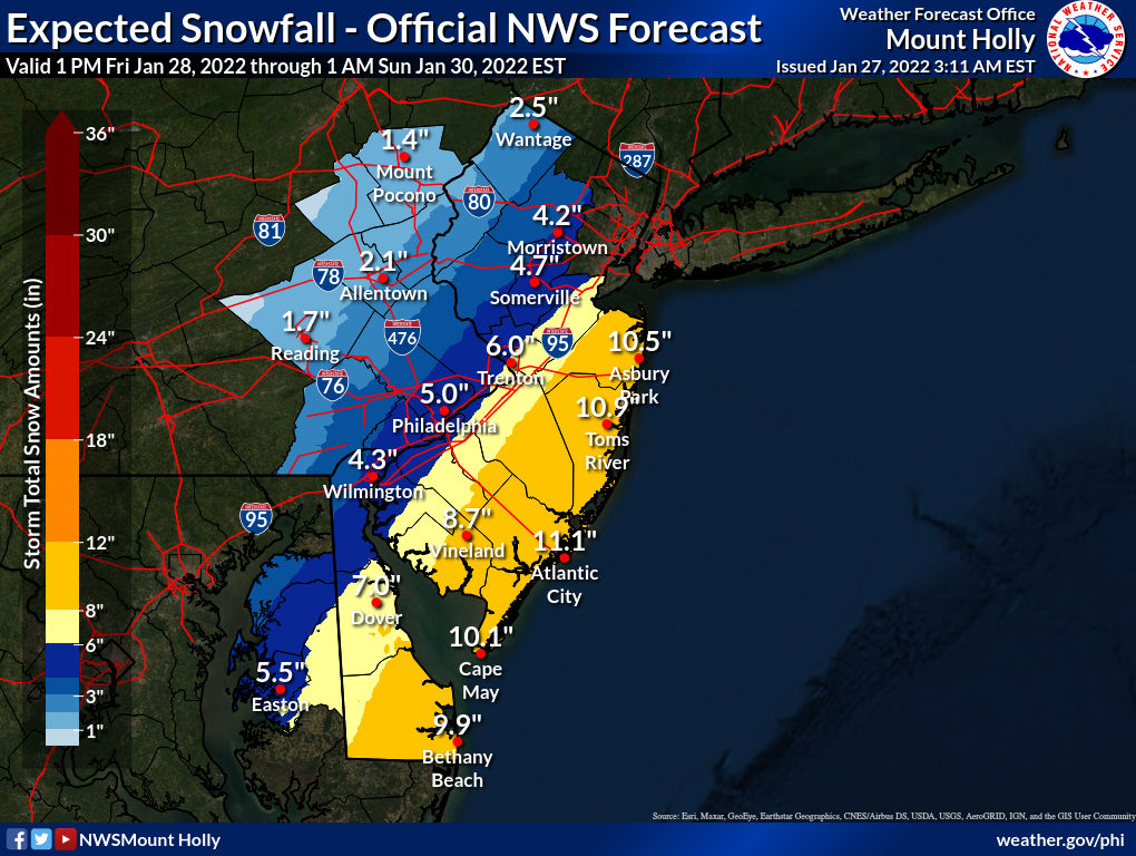
Well, the NWS-NYC dismissed the 18Z NAM for what it's worth, which is why they went with the NBM model blend, which is still quite high (see below), plus the rest of the 18Z suite looks similar (GFS/RDPS) to slightly better (Euro) than it did at 12Z. I feel like I've been saying this for weeks, but I've always felt tonight's 0Z model suite, which will have the full RAOB (radiosonde balloons) initial dataset in place for the first time, with the two main systems over land, plus the NOAA flight data ingested, will be when we hopefully start to see some model consensus. We'll just have to see in a few hours. The rest of the 18Z runs are below, fwiw.
However, the 18Z NAM is an eye opener as it has
shifted well east of the area with no measurable precipitation. This
scenario seems unlikely at this time. Due to the large uncertainty
and bouncing around of the guidance, we are running with a model
blend approach. Should this eastward trend continue with subsequent
runs, snowfall amounts will trend down.


0Z suite time, which is when I've been thinking we'll finally get much closer to model consensus, given the much richer inital condition data inputs (plus just being closer to the event). And Holy Turnaround Batman - the 0Z NAM moved maybe 75 miles NW, not quite as snowy as the 12Z monster, but far more snowy than the essentially snowless 18Z and the upper level evolution/phasing was just a hair from being as good as 12Z, according to the pros at 33. I guess the NWS knew what they were doing by ignoring it, lol. Cannot make this stuff up. Maybe due to much better data inputs at model initialization, but regardless, the two systems were much better aligned and phased much better/earlier, driving the trough negative, which pulled the coastal up towards the benchmark instead of out to sea. Let's see the rest of the 0Z suite before thinking anything has really changed vs. the NAM simply being on crack.

Could be a significant NW trend underway, as the RDPS moved a good 40-50 miles NW and is even snowier than the 0Z NAM; see the graphic below. Also, the 0Z Icon (German model, which is not used much) also moved about 75 miles NW and is far snowier (not going to post it, but it's another data point).

And the 0Z GFS went even further east with snow only along the coast, really (a few inches with little along 95), but it's now alone, as the CMC and the UK both moved significantly west with significant to major snows for most in our area - maps aren't out for those two yet, but have seen the precip fields; maps shortly.

Below is the map for the much snowier CMC model at 0Z, as it moved NW a good 60 miles from 12Z and below that is the far snowier UK model, which shifted 150 miles NW with the storm track and now shows a raging snowstorm (and possibly blizzard for the coast, especially LI) for our whole area, including even NW areas. Euro up next in 90 minutes and it's been rock solid on a major snowstorm for our area for a couple of days now, so one would expect that to continue and if it does, we'll be looking at a significant to major snowstorm for most of the Philly-NJ-NYC area, except well NW of 95.


And last but not least, the 0Z Euro actually looked better in the upper levels than the last 2 runs, but was a smidgen less snowy, as the low scooted a bit further east at the end of the run. Still a 4-7" snowfall for the 95 corridor and 7-10" towards the coast and 2-4" NW. Right now, we actually have fairly remarkable alignment among the Euro, CMC, RDPS, NAM, and UK for a general 4-8" for the 95 corridor, 7-12" towards the coast and 2-5" NW. Hoping to see an updated NBM soon. The GFS is a huge outlier. Watches almost certainly to go up for most (probably not for NW areas) with the 4 am package soon.

Last edited:


