ADVERTISEMENT

OT: Potential Significant to Major Winter Storm Saturday, 1/29/22 (but high uncertainty)

This is even better. In my younger, more wackerish days, I resembled this.

Ycn5tt0.gif
Remember that one… “Fire in the Firehouse “
 
  • Like
Reactions: Knight Shift
I dont know to me it seems like the models are converging on the 2-4, 4-8, 6-10, 8-14 zones depending where you live


I think the fallacy is trying to chase the widespread 12 plus amounts that the nam should for a run or two
Agreed that more than a foot for 95 and NW of there is a low probability, but nowhere near zero chance (maybe 25%), plus there's probably also a 25% chance of the 95 corridor getting 3-5" vs. the roughly 6-10" forecast, which is why I'm liking the NWS snowfall map as a good compromise among the models. Euro up shortly...

K9NE0Lk.png


Edit: adding in Steve DiMartino's forecast graphic, which is a little more bullish than the NWS, but certainly plausible, and Lee Goldberg's numbers, which are a little less than the NWS, but also plausible - although Britney said Lee said he's thinking about moving the snow shield NW, so that the 12" line is on the eastern part of the 95 corridor and the SE part of NYC.

dgwGD72.png


oKneYmY.png
 
Last edited:
  • Like
Reactions: Knight Shift
I happened to view the east coast satellite pictures on the NWS site. It appears to me (I could be completely wrong) that the surface low (storm) is forming way down off the coast of north central Florida . I recall that the projection was for it to form off of Georgia/South Carolina coast. It seems the location is significantly south and maybe a little west (not sure) of the projections. I would think that could impact the forecast in some way.
 
remember that some places might get close to an inch on grassy surfaces from todays light snow...that will be lopped off some of the totals on the model runs, just sayin
 
is that the guy who tries to get people to pay for his weather forecasts?? always makes me laugh.
 
12Z models are all over the place, once again revealing who volatile the setup is, even 12-18 hours before showtime. 12Z UK (below at 10:1 - no Kuchera available, so these numbers should be low) came in at its snowiest in many days, as it has been the eastern outlier. Plus the long range HRRR and the HREFs came in snowier (not posting them yet - probably out of range, but the trend is there).

the
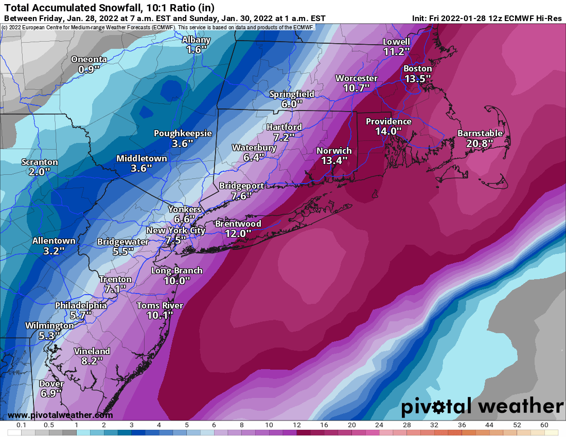
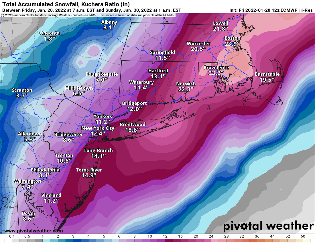
And, of course, the Euro moves back east and weaker with less precip (due to a later phase) to almost where the GFS is now. Can't make this up, lol. Still a major snowstorm for 95 and eastward, but not the storm it was advertising the past few runs. Never easy...

gtV3YfW.png


BmAOTiq.png
 
lets talk favorite storms....mine is February 1983 where I nearly got 2 feet. My first really big snowstorm of all time

I did experience the one in 78. This one they talked about days before, almost a week, and were hyping it but then as we got about 24 hours to the event they started to drop totals and yeah they were saying 1-3/2-4. We all went off to school and I remember the snow starting in the morning sometime and it was already past the time they would call the half day. But it was a quick call for early dismissal immediately within the hour. Remember the big flakes that day the numbers kept going and going up...3-6, 4-8, 6-10, 10-14, 12-18 and then finally 18-24. My first experience with Thundersnow. I think we had 23 IMBY, it was insane to experience that and it would be until Jan 1996 I would experience something that topped it.


Back in NJ, it was 95/96. I'll go with Dec '95 because it was before Christmas. A couple of huge storms that winter, though. Stretches of days in a row in which school was canceled and my buddies and I walked for a good hour or two to a local water tower hill to snowboard.

Two years prior was a good year, too, and my first year on a snowboard, but then 95/96 overshadowed it.
 
If he isn’t already in New Jersey, hope Davin Wydners flight gets in before the snowstorm .
 
And, of course, the Euro moves back east and weaker with less precip (due to a later phase) to almost where the GFS is now. Can't make this up, lol. Still a major snowstorm for 95 and eastward, but not the storm it was advertising the past few runs. Never easy...

gtV3YfW.png


BmAOTiq.png

Actually, in hindsight, the 12Z models, at least the 4 main globals are not all over the place and they're much closer to each other than they've ever been during this whole event progression. Obviously, this is what should happen close to an event, but after all the mayhem (and we'll likely still see some, especially from the meso/CAM/short-range models and of course from the radar), it's fascinating to see. The NWS forecast for the Philly/NYC AFDs, below, is looking pretty good right now, depending of course, on how they account for ratios (still on a quest to find that out), but I included all 4 globals with both Kuchera (roughly 15:1 for most) and the usual 10:1 ratio maps (except the UK, which I only have as a 10:1 map).

Here are the 4 globals at 10:1 ratios...

pd2PTfj.png


JrRWILk.png


uzAoPlK.png


JRxza6N.png


Here are 3 of the globals with Kuchera ratios (roughly 15:1 or 1.5X that of the 10:1 maps); UK doesn't have a Kuchera map and we think the NWS uses an in-house ratio algorithm for ratios that is likely in the 12-14:1 ratio level for this event...

udZPt7P.png


Ck5tXdM.png


A19mnEH.png


K9NE0Lk.png
 
Except if you have animals to feed and water, I have no choice but to be prepared. Just finishing up storm prep now. I've come to absolutely despise putting on the tractor tire chains for the front loader. Everyone makes it look so easy on the videos, for me, it looks like a monkey trying to fvck a football. When I'm done there's tools thrown everywhere.
Hah... Those videos. Just ordered a size-up set of chains for my truck. Current set are the "right size" per the manufacturer (Peerless). But it's a maddeningly tight fit. Always a struggle. They arrive Sunday, supposedly.

Expecting 6"-8" of snow here above Boone NC this afternoon thru tomorrow morning. Winds 20-25 mph with gust to 45. So lots of drifting. Temps in low single digits, with wind-chill towards -10°.
 
Actually, in hindsight, the 12Z models, at least the 4 main globals are not all over the place and they're much closer to each other than they've ever been during this whole event progression. Obviously, this is what should happen close to an event, but after all the mayhem (and we'll likely still see some, especially from the meso/CAM/short-range models and of course from the radar), it's fascinating to see. The NWS forecast for the Philly/NYC AFDs, below, is looking pretty good right now, depending of course, on how they account for ratios (still on a quest to find that out), but I included all 4 globals with both Kuchera (roughly 15:1 for most) and the usual 10:1 ratio maps (except the UK, which I only have as a 10:1 map).

Here are the 4 globals at 10:1 ratios...

pd2PTfj.png


JrRWILk.png


uzAoPlK.png


JRxza6N.png


Here are 3 of the globals with Kuchera ratios (roughly 15:1 or 1.5X that of the 10:1 maps); UK doesn't have a Kuchera map and we think the NWS uses an in-house ratio algorithm for ratios that is likely in the 12-14:1 ratio level for this event...

udZPt7P.png


Ck5tXdM.png


A19mnEH.png


K9NE0Lk.png
So let's go with under 5.6 for Philly as the bust line. Fair enough?
 
  • Like
Reactions: Knight Shift
Steve’s map is laughable. But I guess hyoing a storm like that means subscriptions lol
 
Steve’s map is laughable. But I guess hyoing a storm like that means subscriptions lol
Who cares... more power to him if he's able to make a living as a Twitter weatherman. I've followed him a lot over the years. He's usually a little more optimistic than most
 
  • Like
Reactions: mikemarc1
The updated NWS winter storm and blizzard warnings for Philly/NYC offices and the advisory for NWNJ/SEPA at the bottom...so maps should be out shortly

URGENT - WINTER WEATHER MESSAGE
National Weather Service Mount Holly NJ
330 PM EST Fri Jan 28 2022

New Castle-Kent-Kent MD-Queen Annes-Talbot-Caroline-
Including the cities of Wilmington, Dover, Chestertown,
Centreville, Easton, and Denton
330 PM EST Fri Jan 28 2022

...WINTER STORM WARNING REMAINS IN EFFECT FROM 7 PM THIS EVENING
TO 3 PM EST SATURDAY...

* WHAT...Heavy snow expected. Total snow accumulations of 5 to 10
inches. Winds gusting as high as 40 mph.


URGENT - WINTER WEATHER MESSAGE
National Weather Service Mount Holly NJ
330 PM EST Fri Jan 28 2022

Morris-Hunterdon-Somerset-Middlesex-Mercer-Salem-Gloucester-
Camden-Northwestern Burlington-Cumberland-Delaware-Philadelphia-
Eastern Montgomery-Lower Bucks-
Including the cities of Morristown, Flemington, Somerville,
New Brunswick, Trenton, Pennsville, Glassboro, Camden,
Cherry Hill, Moorestown, Mount Holly, Millville, Media,
Philadelphia, Norristown, Lansdale, Morrisville, and Doylestown
330 PM EST Fri Jan 28 2022

...WINTER STORM WARNING REMAINS IN EFFECT FROM 7 PM THIS EVENING
TO 7 PM EST SATURDAY...

* WHAT...Heavy snow expected. Total snow accumulations of 5 to
11 inches. Winds gusting as high as 40 mph.


URGENT - WINTER WEATHER MESSAGE
National Weather Service New York NY
331 PM EST Fri Jan 28 2022

Western Passaic-Eastern Passaic-Western Bergen-Eastern Bergen-
Western Essex-Eastern Essex-Western Union-Eastern Union-Putnam-
Rockland-Northern Westchester-
331 PM EST Fri Jan 28 2022

...WINTER STORM WARNING REMAINS IN EFFECT FROM 7 PM THIS EVENING
TO 7 PM EST SATURDAY...

* WHAT...Heavy snow expected. Total snow accumulations of 4 to 7
inches. Winds gusting as high as 40 mph.


URGENT - WINTER WEATHER MESSAGE
National Weather Service New York NY
331 PM EST Fri Jan 28 2022

Northern Fairfield-Southern Fairfield-Hudson-Southern Westchester-
New York (Manhattan)-Bronx-Richmond (Staten Island)-
Kings (Brooklyn)-Northern Queens-Southern Queens-
331 PM EST Fri Jan 28 2022

...WINTER STORM WARNING REMAINS IN EFFECT FROM 7 PM THIS EVENING
TO 7 PM EST SATURDAY...

* WHAT...Heavy snow expected. Total snow accumulations of 7 to 10
inches. Winds gusting as high as 45 mph. Near blizzard
conditions are possible for a period on Saturday.


URGENT - WINTER WEATHER MESSAGE
National Weather Service New York NY
331 PM EST Fri Jan 28 2022

Northern New Haven-Northern Middlesex-Southern New Haven-
Southern Middlesex-Northern Nassau-Southern Nassau-
331 PM EST Fri Jan 28 2022

...WINTER STORM WARNING REMAINS IN EFFECT FROM 7 PM THIS EVENING
TO 7 PM EST SATURDAY...

* WHAT...Heavy snow expected. Total snow accumulations of 9 to 12
inches. Winds gusting as high as 45 mph. Near blizzard
conditions are possible for a period on Saturday.


URGENT - WINTER WEATHER MESSAGE
National Weather Service Mount Holly NJ
330 PM EST Fri Jan 28 2022

Inland Sussex-Delaware Beaches-Western Monmouth-Eastern Monmouth-
Ocean-Atlantic-Cape May-Atlantic Coastal Cape May-
Coastal Atlantic-Coastal Ocean-Southeastern Burlington-
Including the cities of Georgetown, Rehoboth Beach, Freehold,
Sandy Hook, Jackson, Hammonton, Cape May Court House, Ocean City,
Atlantic City, Long Beach Island, and Wharton State Forest
330 PM EST Fri Jan 28 2022

...BLIZZARD WARNING REMAINS IN EFFECT FROM 7 PM THIS EVENING TO
7 PM EST SATURDAY...

* WHAT...Blizzard conditions expected. Total snow accumulations of
10 to 18 inches. Winds gusting as high as 50 mph.


URGENT - WINTER WEATHER MESSAGE
National Weather Service New York NY
331 PM EST Fri Jan 28 2022

Northwest Suffolk-Southwest Suffolk-
331 PM EST Fri Jan 28 2022

...BLIZZARD WARNING REMAINS IN EFFECT FROM 7 PM THIS EVENING TO
7 PM EST SATURDAY...

* WHAT...Blizzard conditions expected. Total snow accumulations
of 12 to 16 inches. Winds gusting as high as 55 mph.


URGENT - WINTER WEATHER MESSAGE
National Weather Service New York NY
331 PM EST Fri Jan 28 2022

Northern New London-Southern New London-Northeast Suffolk-
Southeast Suffolk-
331 PM EST Fri Jan 28 2022

...BLIZZARD WARNING REMAINS IN EFFECT FROM 7 PM THIS EVENING TO
7 PM EST SATURDAY...

* WHAT...Blizzard conditions expected. Total snow accumulations
of 13 to 17 inches. Winds gusting as high as 60 mph.

And the NWS advisory for NWNJ/SEPA

URGENT - WINTER WEATHER MESSAGE
National Weather Service Mount Holly NJ
330 PM EST Fri Jan 28 2022

Sussex-Warren-Western Chester-Eastern Chester-Western Montgomery-
Upper Bucks-
Including the cities of Newton, Washington, Honey Brook, Oxford,
West Chester, Kennett Square, Collegeville, Pottstown, Chalfont,
and Perkasie
330 PM EST Fri Jan 28 2022

...WINTER WEATHER ADVISORY REMAINS IN EFFECT FROM 7 PM THIS
EVENING TO 3 PM EST SATURDAY...

* WHAT...Snow expected. Total snow accumulations of 3 to 5
inches. Winds gusting as high as 35 mph.
 
Ok. Let's get into shoveling plans.
Far Eastern Union County/Morris County line (less than a mile north of 78).
I'm guessing approx 6-8"?

Will there be enough snow down tonight to make it worth a first pass of shoveling?
Wake up early and shovel tomorrow morning?
 
Ok. Let's get into shoveling plans.
Far Eastern Union County/Morris County line (less than a mile north of 78).
I'm guessing approx 6-8"?

Will there be enough snow down tonight to make it worth a first pass of shoveling?
Wake up early and shovel tomorrow morning?
I'm going to get a nice buzz and see the conditions at 10/11. Will probably clear it all if it's a couple of inches so less to do in the morning around 6/7.
 
  • Like
Reactions: NickRU714
ADVERTISEMENT
ADVERTISEMENT